CN102930107A - A geography fence based on geography mark media - Google Patents
A geography fence based on geography mark media Download PDFInfo
- Publication number
- CN102930107A CN102930107A CN2012104460946A CN201210446094A CN102930107A CN 102930107 A CN102930107 A CN 102930107A CN 2012104460946 A CN2012104460946 A CN 2012104460946A CN 201210446094 A CN201210446094 A CN 201210446094A CN 102930107 A CN102930107 A CN 102930107A
- Authority
- CN
- China
- Prior art keywords
- user
- geographical
- geography
- fence
- action
- Prior art date
- Legal status (The legal status is an assumption and is not a legal conclusion. Google has not performed a legal analysis and makes no representation as to the accuracy of the status listed.)
- Pending
Links
- 230000009471 action Effects 0.000 claims abstract description 27
- 238000000034 method Methods 0.000 claims description 39
- 238000000605 extraction Methods 0.000 claims description 9
- 230000008569 process Effects 0.000 claims description 9
- 239000000284 extract Substances 0.000 claims description 7
- 230000004044 response Effects 0.000 claims description 3
- 238000007796 conventional method Methods 0.000 abstract 1
- 230000015654 memory Effects 0.000 description 17
- 238000004891 communication Methods 0.000 description 10
- 238000010586 diagram Methods 0.000 description 6
- 238000012545 processing Methods 0.000 description 6
- 238000005516 engineering process Methods 0.000 description 5
- 230000000712 assembly Effects 0.000 description 2
- 238000000429 assembly Methods 0.000 description 2
- 238000013461 design Methods 0.000 description 2
- 230000006870 function Effects 0.000 description 2
- 230000003993 interaction Effects 0.000 description 2
- 230000004048 modification Effects 0.000 description 2
- 238000012986 modification Methods 0.000 description 2
- 230000003287 optical effect Effects 0.000 description 2
- 230000002093 peripheral effect Effects 0.000 description 2
- 230000001960 triggered effect Effects 0.000 description 2
- 240000007594 Oryza sativa Species 0.000 description 1
- 235000007164 Oryza sativa Nutrition 0.000 description 1
- 230000002730 additional effect Effects 0.000 description 1
- 230000006399 behavior Effects 0.000 description 1
- 230000008901 benefit Effects 0.000 description 1
- 230000005540 biological transmission Effects 0.000 description 1
- 238000006243 chemical reaction Methods 0.000 description 1
- 238000010276 construction Methods 0.000 description 1
- 238000006073 displacement reaction Methods 0.000 description 1
- 230000006872 improvement Effects 0.000 description 1
- 230000000977 initiatory effect Effects 0.000 description 1
- 210000003127 knee Anatomy 0.000 description 1
- 230000007246 mechanism Effects 0.000 description 1
- 235000009566 rice Nutrition 0.000 description 1
- 238000004088 simulation Methods 0.000 description 1
- 230000003068 static effect Effects 0.000 description 1
- 239000000758 substrate Substances 0.000 description 1
- 230000007704 transition Effects 0.000 description 1
Images


Classifications
-
- G—PHYSICS
- G06—COMPUTING; CALCULATING OR COUNTING
- G06F—ELECTRIC DIGITAL DATA PROCESSING
- G06F16/00—Information retrieval; Database structures therefor; File system structures therefor
- G06F16/40—Information retrieval; Database structures therefor; File system structures therefor of multimedia data, e.g. slideshows comprising image and additional audio data
- G06F16/48—Retrieval characterised by using metadata, e.g. metadata not derived from the content or metadata generated manually
- G06F16/487—Retrieval characterised by using metadata, e.g. metadata not derived from the content or metadata generated manually using geographical or spatial information, e.g. location
-
- G—PHYSICS
- G06—COMPUTING; CALCULATING OR COUNTING
- G06F—ELECTRIC DIGITAL DATA PROCESSING
- G06F9/00—Arrangements for program control, e.g. control units
- G06F9/06—Arrangements for program control, e.g. control units using stored programs, i.e. using an internal store of processing equipment to receive or retain programs
- G06F9/44—Arrangements for executing specific programs
-
- G—PHYSICS
- G06—COMPUTING; CALCULATING OR COUNTING
- G06F—ELECTRIC DIGITAL DATA PROCESSING
- G06F16/00—Information retrieval; Database structures therefor; File system structures therefor
- G06F16/50—Information retrieval; Database structures therefor; File system structures therefor of still image data
- G06F16/58—Retrieval characterised by using metadata, e.g. metadata not derived from the content or metadata generated manually
-
- G—PHYSICS
- G06—COMPUTING; CALCULATING OR COUNTING
- G06F—ELECTRIC DIGITAL DATA PROCESSING
- G06F17/00—Digital computing or data processing equipment or methods, specially adapted for specific functions
-
- G—PHYSICS
- G01—MEASURING; TESTING
- G01S—RADIO DIRECTION-FINDING; RADIO NAVIGATION; DETERMINING DISTANCE OR VELOCITY BY USE OF RADIO WAVES; LOCATING OR PRESENCE-DETECTING BY USE OF THE REFLECTION OR RERADIATION OF RADIO WAVES; ANALOGOUS ARRANGEMENTS USING OTHER WAVES
- G01S19/00—Satellite radio beacon positioning systems; Determining position, velocity or attitude using signals transmitted by such systems
- G01S19/01—Satellite radio beacon positioning systems transmitting time-stamped messages, e.g. GPS [Global Positioning System], GLONASS [Global Orbiting Navigation Satellite System] or GALILEO
- G01S19/13—Receivers
- G01S19/14—Receivers specially adapted for specific applications
Abstract
A framework is used for creating a geography fence based on geography mark items (such as a photo).The geography mark items can be used for sharing virtual boundary (such as a geography fence) between users via a conventional method sharing digital media (such as an e-mail). An extracting assembly is used for extracting geography positioning information (such as coordinates of latitude and longitude, elevation, direction, distance, and place name or the like) of the geography mark items. The geography positioning information may relate to geographic position performing geographic mark on the items. A boundary assembly then creates a virtual boundary (such as a geography fence) which relates to the geographic position and which is based on the geography positioning information. Thereafter, virtual boundary and attached action are activated when the user spans the boundary (such as connection, and cross). The mark items can be shared with another user, and when processed, the virtual boundary of the another user is created.
Description
Background technology
GEOGRAPHICAL INDICATION (Geo-tagging) is from such as the GPS(GPS) geo-positioning system add the process of the geographical metadata of identification (for example, latitude and longitude coordinate) to media.Camera and mobile device (for example, mobile phone) can be taken the GEOGRAPHICAL INDICATION photograph, and it comprises the geographic coordinate of the physical location of taking photograph.In addition, geographical fence (geo-fence) is just becoming more universal as being used for initiation with respect to the mechanism of the prompting in some geographic position.Yet in order to create geographical fence based on the photograph position, prior art must be used some independent instruments-do not exist single stage solution that creates geographical fence according to the GEOGRAPHICAL INDICATION photograph.
Summary of the invention
Below present the summary of the invention of simplification, in order to the basic comprehension to some novel embodiment that describe is provided herein.This summary of the invention is not extensive overview ot, and it is not to be intended to identify key/essential element or to delimit its scope.Its sole purpose is to present in simplified form some concepts as the in greater detail preamble to presenting after a while.
(for example, photograph, website, document, message, propelling movement etc.) creates geographical fence to disclosed framework based on the GEOGRAPHICAL INDICATION project in single step.In addition, the GEOGRAPHICAL INDICATION project can be used for via classic method (for example, Email) the shared virtual boundary between the user that is used for sharing Digital Media, such as geographical fence.
Usually, framework can comprise the extraction assembly of the geo-localisation information (for example, latitude and longitude coordinate, height above sea level, orientation, distance, place name etc.) that extracts the GEOGRAPHICAL INDICATION project.Geo-localisation information can be relevant with the geographic position of project being carried out the GEOGRAPHICAL INDICATION place.Boundary component creates and to be associated with the geographic position and based on the virtual boundary (for example, geographical fence) of geo-localisation information.
In the situation of photograph, there are the camera of GEOGRAPHICAL INDICATION ability or phone can be used for taking the photograph (for example, the photograph of Conference Room) of particular geographic location.Subsequently from the photograph extract location information.Define geographical fence for the geographic position of extracting.For example, creating diameter around the geographic position of extracting is
XThe circle (or other geometrical construction) of rice.To the geographical fence additional move that creates (for example, remind, notify etc.).Action is to append to the metadata that geographical fence is described.Can be saved in permanent storage parts (for example, local on the equipment and/or externally on the global data base) to geographical fence subsequently.After this, trigger geographical fence when crossing over (for example, engage, intersect) geographical fence the user, and trigger additional action (to the subscriber equipment that has triggered geographical fence or the device transmission different from the equipment that has triggered geographical fence and present prompting).
Can use Email (or any other shared method) and another user to share photograph.The user who receives the GEOGRAPHICAL INDICATION photograph can use above technology to create geographical fence subsequently.Alternatively, can in the photograph metadata, embed one or more the geographical fence action (for example, using exchangeable image file format (EXIF)) that to carry out.Alternatively, can append to the geographical fence action that embeds for the user who has taken photograph and/or received the geographical fence that creates with another user who has processed photograph.Can also photograph metadata encrypt/decrypt with for improvement of security.
In order to finish above and relevant purpose, in conjunction with the following description and drawings some illustrative aspect is described in this article.These aspect indications can be put into practice herein the openly variety of way of principle, and all aspects are intended to be in the scope of claimed theme with its equivalent.Other advantage and novel feature will become obvious according to following detailed description when considering by reference to the accompanying drawings.
Description of drawings
Fig. 1 illustrates the system that meets open framework.
Fig. 2 illustrates the system that promotes that the GEOGRAPHICAL INDICATION project is shared and used.
Fig. 3 illustrates as being embedded in the action in the GEOGRAPHICAL INDICATION project.
Fig. 4 illustrates further employing security component and is used for the mandate of user profile and the system of safety operation control.
Fig. 5 illustrates the method that meets open framework.
Fig. 6 illustrates the further aspect of Fig. 6 method.
Fig. 7 illustrates the alternative method that meets open framework.
Fig. 8 illustrates the further aspect of Fig. 7 method.
Fig. 9 illustrates according to the block diagram of open framework based on the computing system of the geographical fence establishment of the GEOGRAPHICAL INDICATION project implementation.
Embodiment
Geographical fence is virtual periphery or the border that creates explicitly with the geographic position.Geographical fence can dynamically generate (for example, around the radius in shop), perhaps can be the predefine set on border.When knowing that in conjunction with the user's of location-based business operation position equipment (location-aware device) is crossed over or when engaging geographical fence, can generating notice and send (for example, by call, Email etc.) to the user.
Disclosed framework promotes the establishment based on the GEOGRAPHICAL INDICATION project such as photograph in single step of geographical fence.Further, the GEOGRAPHICAL INDICATION project can be used for using current all methods shared geographical fence between people that is used for sharing digital photo.By from GEOGRAPHICAL INDICATION item extraction geo-localisation information, can create geographical fence for this position.
Referring now to figure, wherein, use similar Reference numeral to refer to similar element in the whole text.In the following description, for the purpose of explaining, narrate numerous details in order to its thorough understanding is provided.Yet, will be apparent that not have putting into practice novel embodiment in the situation of these details.In other situation, known configurations and equipment are shown to promote its description with the block diagram form.Be intended that and contain all modifications, equivalent and the alternative scheme that drops in claimed theme tone and the scope.
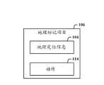
Fig. 1 illustrates the system 100 that meets open framework.System 100 comprises the extraction assembly 102 of the geo-localisation information 104 that extracts GEOGRAPHICAL INDICATION project 106.Geo-localisation information 104 is relevant with the geographic position 108 of project 106 being carried out the GEOGRAPHICAL INDICATION place.Boundary component 110 creates virtual boundary 112 explicitly based on geo-localisation information 104 and geographic position 108.
GEOGRAPHICAL INDICATION project 106 can be photograph.With user's user identifier storing virtual border 112(boundary information explicitly).Boundary component 110 is initiated the action 114 that is associated with the user in response to the joint of knowing the virtual boundary 112 that equipment carries out by user's position.
Fig. 2 illustrates the system 200 that promotes that GEOGRAPHICAL INDICATION project 106 is shared and used.In operation, for example created virtual boundary 112(for first user (user 1), geographical fence) afterwards, extraction based on the geo-localisation information 104 of GEOGRAPHICAL INDICATION project 106, first user for example passes through communications framework 202(, Email) project 106 is sent to the second user (user 2).The second user's system and/or equipment can receive and extraction geo-localisation information 104 from GEOGRAPHICAL INDICATION project 106 subsequently, and the identical or different virtual boundary 204(that generates subsequently for the second user is offset so that clear).Provide storage system 206 with storage first user, GEOGRAPHICAL INDICATION project 106, geo-localisation information 104 and the relation of virtual boundary 112 and the relation of the second user, GEOGRAPHICAL INDICATION project 106, geo-localisation information 104 and virtual boundary 204.Virtual boundary 112 is associated with other (second) user.
Fig. 3 illustrates the action 114 that embeds as in the GEOGRAPHICAL INDICATION project 106.GEOGRAPHICAL INDICATION project 106 can be the photograph that has embedded action message.The action 114 that embeds is activated by the device processes that receives user (the second user) and detecting to receive in the situation that the user engaged virtual boundary.The action 114 that embeds is associated by the device processes that receives (second) user and with the virtual boundary that creates for the reception user.Action can be the notice (for example, reminding) that sends to subscriber equipment.
Fig. 4 illustrates further employing security component 402 and is used for the mandate of user profile and the system 400 of safety operation control.Security component 402 is so that the user can select to add (opt-in) or select to withdraw from (opt-out) that any relation of geo-localisation information, action and/or this information is disclosed to the user.
What comprise herein is that representative is used for carrying out an openly cover flow chart of the exemplary method of framework novel aspect.Although the purpose for simplicity of explanation, for example illustrating with the one or more methods shown in the form of flow chart or process flow diagram herein and being described as a series of actions, but should be appreciated that and understand, method is not limited by running order, because some actions are according to illustrating herein and can occuring simultaneously with different order generations and/or with other action according to it of describing.For example, it will be understood to those of skill in the art that and understand that method can alternately be represented as such as a series of correlation behaviors or event in constitutional diagram.In addition, for novel enforcement, be not the everything that can need example in the method.
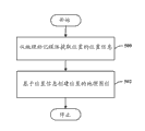
Fig. 5 illustrates the method that meets open framework.500, from the positional information of GEOGRAPHICAL INDICATION media (for example, photograph) extracting position.502, the position-based information pointer creates geographical fence to the position.
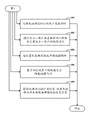
Fig. 6 illustrates the further aspect of Fig. 6 method.Notice that as the additional aspect of the represented method of the flow chart of Fig. 5, this flow process indicates each frame can be separately or show the step that can comprise in conjunction with other frame table.600, when triggering geographical fence, initiate action to the user.602, be that another user creates geographical fence by sharing the GEOGRAPHICAL INDICATION media with another user.604, with positional information explicitly (for example, local or externally in the global data base) store geographical fence.606, trigger geographical fence based on the geo-location of associated user.608, the latitude of extraction GEOGRAPHICAL INDICATION photograph-longitude data is as the positional information that is used for creating geographical fence.
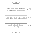
Fig. 7 illustrates the alternative method that meets open framework.700, the GEOGRAPHICAL INDICATION photograph of taking in the position from the user extracts the positional information in geographic position.702, the position-based information pointer creates geographical fence to the position.704, store explicitly geographical fence with positional information and user.
Fig. 8 illustrates the further aspect of Fig. 7 method.Notice that as the additional aspect of the represented method of the flow chart of Fig. 7, flow process indicates each frame can be separately or show the step that can comprise in conjunction with other frame table.800, when knowing the geographical fence of device trigger by user's position, send notice to the user.802, from GEOGRAPHICAL INDICATION photograph extract location information, create geographical fence in this geographical location for this another user in response to the equipment that passes through another user.804, in the GEOGRAPHICAL INDICATION photograph that sends to this another user, embed action message, and the action message of embedding is associated with the geographical fence that creates for this another user.806, the positional information of GEOGRAPHICAL INDICATION photograph is encrypted.
As used in this application, term " assembly " is intended to refer to the relevant entity of computing machine with " system ", the combination of hardware, software and tangible hardware, software or executory software.For example, assembly can be but such as processor, chip memory, mass memory unit (for example be not limited to, optical drive, solid-state drive and/or magnetic storage medium driver) and the tangible assembly of computing machine and so on, and such as the process of moving at processor, object, executable file, data structure (being stored in volatibility or the non-volatile memory medium), module, the thread of execution and/or the component software the program.By way of example, the application and service device that moves on the server all can be assembly.One or more assemblies can reside in the process and/or thread of execution, and assembly can be positioned on the computing machine and/or is distributed between two or more computing machines.Can use in this article word " exemplary " to mean as example, example or diagram.And nonessential any aspect or design describing as " exemplary " herein is construed to preferred or is better than other side or design.
Referring now to Fig. 9, illustrate according to the block diagram of open framework based on the computing system 900 of the geographical fence establishment of the GEOGRAPHICAL INDICATION project implementation.Yet, will be appreciated that the some or all of aspects of open method and/or system may be implemented as SOC (system on a chip), wherein make simulation, numeral, mixed signal and other function at the one single chip substrate.For the extra situation of its various aspects is provided, Fig. 9 and following description are intended to provide concise and to the point, the describe, in general terms of the suitable computing system 900 that can implement therein various aspects.Although above description is in can be in the general status of the computer executable instructions that one or more computing machines move, but it will be recognized by those skilled in the art, also can implement novel embodiment in conjunction with other program module and/or as the combination of hardware and software.
Comprise the computing machine 902 with (a plurality of) processing unit 904, the computer readable storage means such as system storage 906 and system bus 908 for the computing system 900 of implementing various aspects.(a plurality of) processing unit 904 can be any commercial processor in the various commercial processor such as uniprocessor, multiprocessor, monokaryon unit and multinuclear unit.In addition, those skilled in the art will understand, can utilize other computer system configurations to put into practice this novel method, described configuration comprise separately can operation be coupled to one or more associated device small-size computer, mainframe computer and personal computer (for example, desktop, on knee etc.), handheld computing device, based on microprocessor or programmable consumer electronics etc.
Can be at memory sub-system 906, machine readable and removable memory sub-system 918(for example, flash drive form factor technology) and/or (a plurality of) storage subsystem 914(for example, optics, magnetic, solid-state) the middle one or more programs of storage and data, comprise operating system 920, one or more application program 922, other program module 924 and routine data 926.
Usually, program comprises the routine carrying out particular task or implement particular abstract data type, method, data structure, other component software etc.For example also can be in all or part of storer that is cached at such as volatile memory 910 in operating system 920, application 922, module 924 and/or the data 926.Should understand, can utilize the combination (for example, as virtual machine) of various commercial operation systems or operating system to implement disclosed framework.
(a plurality of) storage subsystem 914 and memory sub-system (906 and 918) are as the volatibility of data, data structure, computer executable instructions etc. and the computer-readable medium of non-volatile memories.This instruction can be so that one or more actions of computing machine or other machine manner of execution when carrying out by computing machine or other machine.Can or can store at a plurality of media in the instruction of medium storage execution action so that instruction manifests in that one or more computer-readable recording medium is unified, and no matter all instructions whether on same medium.
Computer-readable medium can be any usable medium that can access of computing machine 902 and comprise removable or non-removable volatibility and non-volatile inside and/or external agency.For computing machine 902, the medium accommodating data are with the storage of any suitable digital format.Those skilled in the art will be appreciated that other type computer computer-readable recording medium that can adopt such as zip disk drive, tape, flash card, flash drive, magnetic holder etc. is so that storage is used for carrying out the openly computer executable instructions of the novel method of framework.
The user can use the external user input equipment 928 and computing machine 902, program and data interaction such as keyboard and mouse.Other external user input equipment 928 can comprise that microphone, IR(are infrared) remote control, operating rod, game paddle, video camera identification system, writing pencil, touch-screen, attitude system (for example, eye moves, head move etc.) and/or analog.The user can use such as touch pad, microphone, keyboard, etc. plate carry (onboard) user input device 930 and computing machine 902, program and data interaction, wherein, computing machine 902 for example is portable computer.These and other input equipment is connected to (a plurality of) processing unit 904 via system bus 908 by (a plurality of) I/O (I/O) equipment interface 932, but can be by such as parallel port, IEEE 1394 serial ports, game port, USB port, IR interface, short-distance radio (for example, bluetooth) and other interface connection of territory net (PAN) technology etc. and so on of being connected.(a plurality of) I/O equipment interface 932 also promotes the use of the output peripheral components 934 such as printer, audio frequency apparatus, camera apparatus etc., as, sound card and/or plate-carried audio-frequency processing power.
One or more graphic interface 936(also are referred to as Graphics Processing Unit (GPU)) for example provide computing machine 902 and (a plurality of) external display 938(, LCD, plasma) and/or plate for example carry display 940(, for pocket computer) between figure and vision signal.Graphic interface 936 also can be manufactured to the part of computer system board.
When via wire/wireless communication subsystem 942(for example use computer-chronograph 902 in networked environment, network interface adapter, plate carry transceiver subsystem etc.) be connected to network to communicate by letter with wire/radio network, wire/wireless printer, wire/wireless input equipment 944 etc.Computing machine 902 can comprise for modulator-demodular unit or other device of setting up communication at network.In networked environment, can be as with distributed system be associated, storage is with respect to program and the data of computing machine 902 in remote memory/storage device.Will understand, the network connection that illustrates is exemplary, and can use other device of setting up communication link between computing machine.
Content described above comprises the example of open framework.Certainly, can't describe each conceived combination of assembly and/or method, but those skilled in the art will realize that many further combinations and displacement are possible.Correspondingly, novel framework is intended to comprise all this conversion, the modifications and variations that drop in the claims spirit and scope.Moreover, in embodiment or claim, use aspect term " comprises ", this term be intended to with as explain that when adopting as the transition word in the claim term of " comprising " " comprises " similar comprising property of mode.
Claims (10)
1. a system (100) comprising:
Extraction assembly (102), it extracts the geo-localisation information of GEOGRAPHICAL INDICATION project, and geo-localisation information is relevant with the geographic position of project being carried out the GEOGRAPHICAL INDICATION place;
Boundary component (110), it creates virtual boundary explicitly based on geo-localisation information and geographic position; And
At least one computer executable instructions that is associated in the processor, its execution and extraction assembly or boundary component.
2. the system as claimed in claim 1, wherein, with user's user identifier storing virtual border explicitly.
3. system as claimed in claim 2, wherein, boundary component is in response to knowing that by user's position the joint of the virtual boundary that equipment carries out initiates the action that is associated with the user.
4. the system as claimed in claim 1 wherein, via sharing with another user of geographical tagging items access shared virtual boundary, makes virtual boundary be associated with described another user subsequently.
5. the system as claimed in claim 1, wherein, the GEOGRAPHICAL INDICATION project is the photograph that has embedded action message, the action message of embedding is by the device processes that receives the user, and is activated detecting to receive in the situation that the user engaged virtual boundary.
6. method comprises action:
Positional information (500) from GEOGRAPHICAL INDICATION media extracting position;
The geographical fence (502) of position-based information creating position; And
At least one action in the action of using the processor execution extraction of the instruction of storing in the execute store or creating.
7. method as claimed in claim 6, further comprise: the geo-location based on associated user triggers geographical fence, and initiates action to the user when triggering geographical fence.
8. method as claimed in claim 6 further comprises: by sharing the geographical fence that the GEOGRAPHICAL INDICATION media create described another user with another user.
9. method as claimed in claim 6 further comprises: store explicitly geographical fence with positional information.
10. method as claimed in claim 6 further comprises: extract the latitude of GEOGRAPHICAL INDICATION photograph-longitude data as the positional information that is used for creating geographical fence.
Applications Claiming Priority (2)
| Application Number | Priority Date | Filing Date | Title |
|---|---|---|---|
| US13/293,095 US20130117266A1 (en) | 2011-11-09 | 2011-11-09 | Geo-fence based on geo-tagged media |
| US13/293095 | 2011-11-09 |
Publications (1)
| Publication Number | Publication Date |
|---|---|
| CN102930107A true CN102930107A (en) | 2013-02-13 |
Family
ID=47644904
Family Applications (1)
| Application Number | Title | Priority Date | Filing Date |
|---|---|---|---|
| CN2012104460946A Pending CN102930107A (en) | 2011-11-09 | 2012-11-09 | A geography fence based on geography mark media |
Country Status (6)
| Country | Link |
|---|---|
| US (1) | US20130117266A1 (en) |
| EP (1) | EP2776921A4 (en) |
| JP (1) | JP2014532951A (en) |
| KR (1) | KR20140089537A (en) |
| CN (1) | CN102930107A (en) |
| WO (1) | WO2013070811A1 (en) |
Cited By (25)
| Publication number | Priority date | Publication date | Assignee | Title |
|---|---|---|---|---|
| CN104053127A (en) * | 2013-03-14 | 2014-09-17 | 福特全球技术公司 | Method and Apparatus for Enhanced Driving Experience Including Dynamic POI Identification |
| CN105191361A (en) * | 2013-02-22 | 2015-12-23 | 英特尔公司 | Geo-fence notification management |
| WO2016154941A1 (en) * | 2015-03-31 | 2016-10-06 | SZ DJI Technology Co., Ltd. | Systems and methods for displaying geo-fencing device information |
| CN106068656A (en) * | 2014-02-11 | 2016-11-02 | 谷歌公司 | The virtual geographical perimeter being made up of multiple component shapes |
| US9792613B2 (en) | 2015-03-31 | 2017-10-17 | SZ DJI Technology Co., Ltd | Authentication systems and methods for generating flight regulations |
| CN107291784A (en) * | 2016-04-13 | 2017-10-24 | 阿里巴巴集团控股有限公司 | Acquisition methods, device and the business device of geography fence classification |
| CN107396317A (en) * | 2013-12-05 | 2017-11-24 | 电子湾有限公司 | Geo-fencing system |
| CN107430402A (en) * | 2015-03-31 | 2017-12-01 | 深圳市大疆创新科技有限公司 | For being identified to geographical railing device and the system and method for certification |
| CN107637099A (en) * | 2015-03-18 | 2018-01-26 | 斯纳普公司 | Geography fence certification provides |
| CN108318902A (en) * | 2017-11-22 | 2018-07-24 | 和芯星通(上海)科技有限公司 | Adaptive geo-fence detection method and device, electronic equipment and management method |
| WO2018223346A1 (en) * | 2017-06-08 | 2018-12-13 | 深圳市乃斯网络科技有限公司 | Method and system for positioning in photograph sharing |
| CN110415012A (en) * | 2019-06-05 | 2019-11-05 | 中国联合网络通信集团有限公司 | Dynamic scene area determination method, device, equipment and readable storage medium storing program for executing |
| CN110602641A (en) * | 2019-09-17 | 2019-12-20 | 深圳市和讯华谷信息技术有限公司 | Wireless network pushing method and system based on geo-fencing |
| CN112929828A (en) * | 2013-11-28 | 2021-06-08 | 微软技术许可有限责任公司 | Geofence composition |
| US11094202B2 (en) | 2015-03-31 | 2021-08-17 | SZ DJI Technology Co., Ltd. | Systems and methods for geo-fencing device communications |
| US11166121B2 (en) | 2014-06-13 | 2021-11-02 | Snap Inc. | Prioritization of messages within a message collection |
| US11190679B2 (en) | 2014-11-12 | 2021-11-30 | Snap Inc. | Accessing media at a geographic location |
| US11216869B2 (en) | 2014-09-23 | 2022-01-04 | Snap Inc. | User interface to augment an image using geolocation |
| US11250887B2 (en) | 2014-12-19 | 2022-02-15 | Snap Inc. | Routing messages by message parameter |
| US11281701B2 (en) | 2014-09-18 | 2022-03-22 | Snap Inc. | Geolocation-based pictographs |
| US11468615B2 (en) | 2015-12-18 | 2022-10-11 | Snap Inc. | Media overlay publication system |
| US11496544B2 (en) | 2015-05-05 | 2022-11-08 | Snap Inc. | Story and sub-story navigation |
| US11558678B2 (en) | 2017-03-27 | 2023-01-17 | Snap Inc. | Generating a stitched data stream |
| US11803345B2 (en) | 2014-12-19 | 2023-10-31 | Snap Inc. | Gallery of messages from individuals with a shared interest |
| US11972014B2 (en) | 2021-04-19 | 2024-04-30 | Snap Inc. | Apparatus and method for automated privacy protection in distributed images |
Families Citing this family (15)
| Publication number | Priority date | Publication date | Assignee | Title |
|---|---|---|---|---|
| US20140248912A1 (en) * | 2013-03-01 | 2014-09-04 | Barracuda Networks, Inc. | Systems and methods for sharing of geo-tagged file segments based on location of a mobile device |
| US20140365307A1 (en) * | 2013-06-07 | 2014-12-11 | Ebay Inc. | Transmitting listings based on detected location |
| US20150149542A1 (en) * | 2013-11-27 | 2015-05-28 | Chintan Jain | System and methods for generating and provisioning a personalized geo-fence |
| US8938488B1 (en) * | 2013-12-27 | 2015-01-20 | Linkedin Corporation | Techniques for populating a content stream on a mobile device |
| CN104063423B (en) * | 2014-05-30 | 2017-11-21 | 小米科技有限责任公司 | A kind of method and device for determining position |
| US10387457B2 (en) * | 2014-06-17 | 2019-08-20 | Sap Se | Grid-based analysis of geospatial trajectories |
| US9413786B1 (en) | 2015-02-04 | 2016-08-09 | International Business Machines Corporation | Dynamic enterprise security control based on user risk factors |
| US10120948B2 (en) | 2015-10-13 | 2018-11-06 | Google Llc | Providing notifications based on geofencing search results |
| US9918191B2 (en) * | 2015-10-26 | 2018-03-13 | Intel Corporation | Mobile geo-fence system |
| US9992620B2 (en) | 2016-05-09 | 2018-06-05 | Hippware, Inc. | Platform for geo-fence social media |
| US9589255B1 (en) | 2016-09-14 | 2017-03-07 | Graffiti Video Inc. | Collaborative media capture and sharing system |
| CN108389351A (en) * | 2018-04-24 | 2018-08-10 | 成都恒高科技有限公司 | Tag match, fence border control method, apparatus and storage medium |
| CN109819403B (en) * | 2019-01-28 | 2021-07-23 | 汉海信息技术(上海)有限公司 | Method and device for generating electronic fence and electronic equipment |
| KR102249383B1 (en) * | 2019-04-25 | 2021-05-07 | 군산대학교 산학협력단 | Method of Discovering Region of Attractions from Geo-tagged Photos and Apparatus Thereof |
| US11900394B1 (en) * | 2020-11-13 | 2024-02-13 | Gen Digital Inc. | Location-based anomaly detection based on geotagged digital photographs |
Citations (6)
| Publication number | Priority date | Publication date | Assignee | Title |
|---|---|---|---|---|
| US20060270421A1 (en) * | 2005-05-27 | 2006-11-30 | Alan Phillips | Location-based services |
| CN101688911A (en) * | 2007-07-06 | 2010-03-31 | 高通股份有限公司 | Tracking implementing geopositioning and local modes |
| CN101802879A (en) * | 2007-04-03 | 2010-08-11 | 人类网络实验室公司 | Method and apparatus for acquiring local position and overlaying information |
| CN101861744A (en) * | 2007-12-27 | 2010-10-13 | 真实定位公司 | Subscriber selective, area-based service control |
| US20100273504A1 (en) * | 2009-04-22 | 2010-10-28 | Trueposition, Inc. | Network Autonomous Wireless Location System |
| US8018329B2 (en) * | 2008-12-12 | 2011-09-13 | Gordon * Howard Associates, Inc. | Automated geo-fence boundary configuration and activation |
Family Cites Families (9)
| Publication number | Priority date | Publication date | Assignee | Title |
|---|---|---|---|---|
| US6411899B2 (en) * | 1996-10-24 | 2002-06-25 | Trimble Navigation Ltd. | Position based personal digital assistant |
| JP2000181814A (en) * | 1998-12-14 | 2000-06-30 | Nec Corp | Electronic mail system |
| US7385499B2 (en) * | 2004-12-17 | 2008-06-10 | United Parcel Service Of America, Inc. | Item-based monitoring systems and methods |
| EP2015024A3 (en) * | 2007-06-19 | 2009-03-25 | GroundSpeak, Inc. | System and method for providing player interfacing layouts for geolocational activities |
| US20090005071A1 (en) * | 2007-06-28 | 2009-01-01 | Apple Inc. | Event Triggered Content Presentation |
| US8170580B2 (en) * | 2008-11-04 | 2012-05-01 | International Business Machines Corporation | Geo-boundary triggered messaging and schedule system and method of use |
| US8577590B2 (en) * | 2009-11-09 | 2013-11-05 | Qualcomm Incorporated | Scalable geofences |
| US8284748B2 (en) * | 2010-07-07 | 2012-10-09 | Apple Inc. | Ad hoc formation and tracking of location-sharing groups |
| US20120324018A1 (en) * | 2011-06-16 | 2012-12-20 | Yahoo! Inc. | Systems and methods for location based social network |
-
2011
- 2011-11-09 US US13/293,095 patent/US20130117266A1/en not_active Abandoned
-
2012
- 2012-11-08 WO PCT/US2012/064004 patent/WO2013070811A1/en active Application Filing
- 2012-11-08 EP EP12847017.6A patent/EP2776921A4/en not_active Withdrawn
- 2012-11-08 JP JP2014541209A patent/JP2014532951A/en not_active Ceased
- 2012-11-08 KR KR1020147012424A patent/KR20140089537A/en not_active Application Discontinuation
- 2012-11-09 CN CN2012104460946A patent/CN102930107A/en active Pending
Patent Citations (6)
| Publication number | Priority date | Publication date | Assignee | Title |
|---|---|---|---|---|
| US20060270421A1 (en) * | 2005-05-27 | 2006-11-30 | Alan Phillips | Location-based services |
| CN101802879A (en) * | 2007-04-03 | 2010-08-11 | 人类网络实验室公司 | Method and apparatus for acquiring local position and overlaying information |
| CN101688911A (en) * | 2007-07-06 | 2010-03-31 | 高通股份有限公司 | Tracking implementing geopositioning and local modes |
| CN101861744A (en) * | 2007-12-27 | 2010-10-13 | 真实定位公司 | Subscriber selective, area-based service control |
| US8018329B2 (en) * | 2008-12-12 | 2011-09-13 | Gordon * Howard Associates, Inc. | Automated geo-fence boundary configuration and activation |
| US20100273504A1 (en) * | 2009-04-22 | 2010-10-28 | Trueposition, Inc. | Network Autonomous Wireless Location System |
Cited By (42)
| Publication number | Priority date | Publication date | Assignee | Title |
|---|---|---|---|---|
| CN105191361A (en) * | 2013-02-22 | 2015-12-23 | 英特尔公司 | Geo-fence notification management |
| CN104053127A (en) * | 2013-03-14 | 2014-09-17 | 福特全球技术公司 | Method and Apparatus for Enhanced Driving Experience Including Dynamic POI Identification |
| CN112929828A (en) * | 2013-11-28 | 2021-06-08 | 微软技术许可有限责任公司 | Geofence composition |
| US11252531B2 (en) | 2013-12-05 | 2022-02-15 | Ebay Inc. | Methods, systems, and apparatus for a geo-fence system |
| CN107396317A (en) * | 2013-12-05 | 2017-11-24 | 电子湾有限公司 | Geo-fencing system |
| CN106068656A (en) * | 2014-02-11 | 2016-11-02 | 谷歌公司 | The virtual geographical perimeter being made up of multiple component shapes |
| US11166121B2 (en) | 2014-06-13 | 2021-11-02 | Snap Inc. | Prioritization of messages within a message collection |
| US11317240B2 (en) | 2014-06-13 | 2022-04-26 | Snap Inc. | Geo-location based event gallery |
| US11281701B2 (en) | 2014-09-18 | 2022-03-22 | Snap Inc. | Geolocation-based pictographs |
| US11741136B2 (en) | 2014-09-18 | 2023-08-29 | Snap Inc. | Geolocation-based pictographs |
| US11216869B2 (en) | 2014-09-23 | 2022-01-04 | Snap Inc. | User interface to augment an image using geolocation |
| US11190679B2 (en) | 2014-11-12 | 2021-11-30 | Snap Inc. | Accessing media at a geographic location |
| US11956533B2 (en) | 2014-11-12 | 2024-04-09 | Snap Inc. | Accessing media at a geographic location |
| US11783862B2 (en) | 2014-12-19 | 2023-10-10 | Snap Inc. | Routing messages by message parameter |
| US11250887B2 (en) | 2014-12-19 | 2022-02-15 | Snap Inc. | Routing messages by message parameter |
| US11803345B2 (en) | 2014-12-19 | 2023-10-31 | Snap Inc. | Gallery of messages from individuals with a shared interest |
| CN107637099A (en) * | 2015-03-18 | 2018-01-26 | 斯纳普公司 | Geography fence certification provides |
| US11902287B2 (en) | 2015-03-18 | 2024-02-13 | Snap Inc. | Geo-fence authorization provisioning |
| US10616239B2 (en) | 2015-03-18 | 2020-04-07 | Snap Inc. | Geo-fence authorization provisioning |
| CN107637099B (en) * | 2015-03-18 | 2020-10-16 | 斯纳普公司 | Geo-fence authentication provisioning |
| US10893055B2 (en) | 2015-03-18 | 2021-01-12 | Snap Inc. | Geo-fence authorization provisioning |
| US9870566B2 (en) | 2015-03-31 | 2018-01-16 | SZ DJI Technology Co., Ltd | Authentication systems and methods for generating flight regulations |
| US11094202B2 (en) | 2015-03-31 | 2021-08-17 | SZ DJI Technology Co., Ltd. | Systems and methods for geo-fencing device communications |
| US11961093B2 (en) | 2015-03-31 | 2024-04-16 | SZ DJI Technology Co., Ltd. | Authentication systems and methods for generating flight regulations |
| WO2016154941A1 (en) * | 2015-03-31 | 2016-10-06 | SZ DJI Technology Co., Ltd. | Systems and methods for displaying geo-fencing device information |
| US9792613B2 (en) | 2015-03-31 | 2017-10-17 | SZ DJI Technology Co., Ltd | Authentication systems and methods for generating flight regulations |
| US11120456B2 (en) | 2015-03-31 | 2021-09-14 | SZ DJI Technology Co., Ltd. | Authentication systems and methods for generating flight regulations |
| US9805607B2 (en) | 2015-03-31 | 2017-10-31 | SZ DJI Technology Co., Ltd. | Authentication systems and methods for generating flight regulations |
| CN107430402A (en) * | 2015-03-31 | 2017-12-01 | 深圳市大疆创新科技有限公司 | For being identified to geographical railing device and the system and method for certification |
| US11367081B2 (en) | 2015-03-31 | 2022-06-21 | SZ DJI Technology Co., Ltd. | Authentication systems and methods for generating flight regulations |
| US9805372B2 (en) | 2015-03-31 | 2017-10-31 | SZ DJI Technology Co., Ltd | Authentication systems and methods for generating flight regulations |
| US11496544B2 (en) | 2015-05-05 | 2022-11-08 | Snap Inc. | Story and sub-story navigation |
| US11830117B2 (en) | 2015-12-18 | 2023-11-28 | Snap Inc | Media overlay publication system |
| US11468615B2 (en) | 2015-12-18 | 2022-10-11 | Snap Inc. | Media overlay publication system |
| CN107291784A (en) * | 2016-04-13 | 2017-10-24 | 阿里巴巴集团控股有限公司 | Acquisition methods, device and the business device of geography fence classification |
| CN107291784B (en) * | 2016-04-13 | 2020-08-04 | 阿里巴巴集团控股有限公司 | Method and device for acquiring geo-fence categories and business equipment |
| US11558678B2 (en) | 2017-03-27 | 2023-01-17 | Snap Inc. | Generating a stitched data stream |
| WO2018223346A1 (en) * | 2017-06-08 | 2018-12-13 | 深圳市乃斯网络科技有限公司 | Method and system for positioning in photograph sharing |
| CN108318902A (en) * | 2017-11-22 | 2018-07-24 | 和芯星通(上海)科技有限公司 | Adaptive geo-fence detection method and device, electronic equipment and management method |
| CN110415012A (en) * | 2019-06-05 | 2019-11-05 | 中国联合网络通信集团有限公司 | Dynamic scene area determination method, device, equipment and readable storage medium storing program for executing |
| CN110602641A (en) * | 2019-09-17 | 2019-12-20 | 深圳市和讯华谷信息技术有限公司 | Wireless network pushing method and system based on geo-fencing |
| US11972014B2 (en) | 2021-04-19 | 2024-04-30 | Snap Inc. | Apparatus and method for automated privacy protection in distributed images |
Also Published As
| Publication number | Publication date |
|---|---|
| KR20140089537A (en) | 2014-07-15 |
| EP2776921A4 (en) | 2016-04-13 |
| EP2776921A1 (en) | 2014-09-17 |
| WO2013070811A1 (en) | 2013-05-16 |
| JP2014532951A (en) | 2014-12-08 |
| US20130117266A1 (en) | 2013-05-09 |
Similar Documents
| Publication | Publication Date | Title |
|---|---|---|
| CN102930107A (en) | A geography fence based on geography mark media | |
| US10462128B2 (en) | Verification of both identification and presence of objects over a network | |
| US8757477B2 (en) | Identifier generation for visual beacon | |
| EP2959702B1 (en) | Geo-fence notification management | |
| CN103222319B (en) | A kind of method for mobile computing device and mobile computing device | |
| US20140152852A1 (en) | Predetermined-area management system, communication method, and computer program product | |
| CN103535057A (en) | Discovering nearby places based on automatic query | |
| US20190318076A1 (en) | Augmented reality object providing method and server using image authentication | |
| US20120144468A1 (en) | Systems, Methods, and Computer Program Products for User Authentication | |
| KR20170129222A (en) | Geo-fence Provisioning | |
| KR20170043537A (en) | Geo-fencing notifications subscriptions | |
| CN102461136A (en) | Remotely locating and commanding a mobile device | |
| CN111295898B (en) | Motion-based display content charting control | |
| JP2015507295A (en) | User search method, user search system, and user search device in a social network | |
| CN105765539A (en) | User support experience with automatically generated virtual environment | |
| CN104903880A (en) | Unified communications with a cloud client device | |
| JP6832098B2 (en) | Equipment, computer programs and methods | |
| EP3567887A1 (en) | Communication method and device | |
| CN103220207A (en) | Instant message communication method and instant message communication equipment based on locations | |
| US10007404B2 (en) | Terminal apparatus, program, method of calling function, and information processing system | |
| EP3701684A1 (en) | Geographically-driven group communications | |
| US9609508B2 (en) | Forced operating of software on a remote terminal | |
| CN108834065B (en) | Online sign-in method and device | |
| US9807214B2 (en) | Temporary contacts | |
| US10460000B2 (en) | Determining a location and area of a place |
Legal Events
| Date | Code | Title | Description |
|---|---|---|---|
| C06 | Publication | ||
| PB01 | Publication | ||
| C10 | Entry into substantive examination | ||
| SE01 | Entry into force of request for substantive examination | ||
| ASS | Succession or assignment of patent right |
Owner name: MICROSOFT TECHNOLOGY LICENSING LLC Free format text: FORMER OWNER: MICROSOFT CORP. Effective date: 20150703 |
|
| C41 | Transfer of patent application or patent right or utility model | ||
| TA01 | Transfer of patent application right |
Effective date of registration: 20150703 Address after: Washington State Applicant after: Micro soft technique license Co., Ltd Address before: Washington State Applicant before: Microsoft Corp. |
|
| C02 | Deemed withdrawal of patent application after publication (patent law 2001) | ||
| WD01 | Invention patent application deemed withdrawn after publication |
Application publication date: 20130213 |