EP1696207A1 - Method and system for determining an object's position data - Google Patents
Method and system for determining an object's position data Download PDFInfo
- Publication number
- EP1696207A1 EP1696207A1 EP06003242A EP06003242A EP1696207A1 EP 1696207 A1 EP1696207 A1 EP 1696207A1 EP 06003242 A EP06003242 A EP 06003242A EP 06003242 A EP06003242 A EP 06003242A EP 1696207 A1 EP1696207 A1 EP 1696207A1
- Authority
- EP
- European Patent Office
- Prior art keywords
- receiver
- position information
- attribute
- speed
- fix
- Prior art date
- Legal status (The legal status is an assumption and is not a legal conclusion. Google has not performed a legal analysis and makes no representation as to the accuracy of the status listed.)
- Granted
Links
- 238000000034 method Methods 0.000 title claims description 38
- 238000012795 verification Methods 0.000 claims abstract description 7
- 238000001514 detection method Methods 0.000 claims description 26
- 238000012360 testing method Methods 0.000 claims description 12
- 230000005540 biological transmission Effects 0.000 claims description 5
- 238000010790 dilution Methods 0.000 claims description 3
- 239000012895 dilution Substances 0.000 claims description 3
- 238000012545 processing Methods 0.000 description 4
- 230000001419 dependent effect Effects 0.000 description 3
- 230000004927 fusion Effects 0.000 description 3
- 238000005070 sampling Methods 0.000 description 3
- 230000006399 behavior Effects 0.000 description 2
- 230000007613 environmental effect Effects 0.000 description 2
- 238000012552 review Methods 0.000 description 2
- 230000003068 static effect Effects 0.000 description 2
- 238000013461 design Methods 0.000 description 1
- 238000011161 development Methods 0.000 description 1
- 230000018109 developmental process Effects 0.000 description 1
- 238000011143 downstream manufacturing Methods 0.000 description 1
- 238000001914 filtration Methods 0.000 description 1
- 230000006870 function Effects 0.000 description 1
- 230000006266 hibernation Effects 0.000 description 1
- 238000012544 monitoring process Methods 0.000 description 1
- 230000000284 resting effect Effects 0.000 description 1
- 230000035945 sensitivity Effects 0.000 description 1
- 230000007958 sleep Effects 0.000 description 1
Images


Classifications
-
- G—PHYSICS
- G07—CHECKING-DEVICES
- G07B—TICKET-ISSUING APPARATUS; FARE-REGISTERING APPARATUS; FRANKING APPARATUS
- G07B15/00—Arrangements or apparatus for collecting fares, tolls or entrance fees at one or more control points
- G07B15/06—Arrangements for road pricing or congestion charging of vehicles or vehicle users, e.g. automatic toll systems
-
- G—PHYSICS
- G01—MEASURING; TESTING
- G01S—RADIO DIRECTION-FINDING; RADIO NAVIGATION; DETERMINING DISTANCE OR VELOCITY BY USE OF RADIO WAVES; LOCATING OR PRESENCE-DETECTING BY USE OF THE REFLECTION OR RERADIATION OF RADIO WAVES; ANALOGOUS ARRANGEMENTS USING OTHER WAVES
- G01S19/00—Satellite radio beacon positioning systems; Determining position, velocity or attitude using signals transmitted by such systems
- G01S19/38—Determining a navigation solution using signals transmitted by a satellite radio beacon positioning system
- G01S19/39—Determining a navigation solution using signals transmitted by a satellite radio beacon positioning system the satellite radio beacon positioning system transmitting time-stamped messages, e.g. GPS [Global Positioning System], GLONASS [Global Orbiting Navigation Satellite System] or GALILEO
- G01S19/42—Determining position
Definitions
- the present invention relates to a method and a system for determining position data of an object.
- GPS Global Positioning System
- the position data thus obtained which are also referred to as fix in a GPS system, can be used for different purposes.
- a navigation system it is possible to supply these position data to a navigation system, to use this as an input for a fee system for the determination of a route toll (toll system) or a monitoring of the driving of an area for demographic reasons.
- a navigation system which includes a receiving and evaluating unit for satellite signals for position determination having.
- a sensor disposed in the vehicle is used.
- This sensor can be a direction sensor, for example in the form of a rotation rate sensor.
- the distinction between a sleep state and a move state is made by using the noise of the sensor signal as a discrimination criterion.
- the invention is based on the finding that this object can be achieved by using criteria for increasing the integrity that are provided by the satellite-based system itself.
- this relates to a method for determining position data of an object, in which signals for position detection are transmitted by a position-determining system to a receiver assigned to the object, where position information is determined from the detected signals.
- the method is characterized in that the position information determined at the receiver is subjected to a test, wherein at least one attribute of the receiver is used as a test criterion and the value of the at least one attribute is compared with at least one limit value.
- An object in the sense of this invention is in particular a vehicle, preferably a motor vehicle.
- attributes of the receiver which, in addition to the pure position information in the form of coordinates, can be determined from the signals transmitted by the position-finding system to the receiver for determining the position or are derived from the determined position information.
- the position information determined from the signals for determining the position are also referred to below as detected or determined position information.
- the value of the attributes is available or can be derived.
- the speed of the receiver (speed) and / or the angle of the receiver (course) can be used as attributes.
- Another attribute may be, for example, the spatial distance between detected positions, which are referred to below as fixes.
- further directional information of the receiver which represent derived variables, can be used.
- the desired course the direction of movement and / or the angle between the directions of movement of the receiver in two positions of the receiver can be attributes.
- the fulfillment of a predefinable condition can be checked. For this comparison, no values are required, which must be recorded by other sensors. Rather, the comparison uses attributes from the Signals of the position detection system are determined at the receiver.
- the method according to the invention thus offers an integral system in which, in particular, sensor fusion is not necessary, as a result of which the method is considerably simplified in comparison to the prior art.
- the attributes of the recipient can always be reliably assigned to a position specification, so that a separate assignment can be omitted and the review still takes into account the facts actually present.
- the position information is filtered depending on the result of the check. This means that only the position information that satisfies the conditions defined by the threshold or other test criteria is recognized as valid, valid and / or usable, while the position information leading to a negative test result may be discarded.
- the position information recognized as valid, valid and / or usable can be provided on its own or with additional information for further use. This further use may be a subsequent verification step or a processing in a downstream process, such as a navigation system or a toll collection system.
- a position specification is considered permissible if it fulfills all requirements that are specified.
- position information is valid and usable.
- a valid position indication can at least be used to register the detection of a position.
- a position specification is valid, in particular, if it has a certain quality and, moreover, does not exceed a predefinable maximum distance to a previously recorded position specification.
- a position indication is designated as usable if, according to its properties, it is suitable for serving as an input variable for further calculations of the method or of a downstream system.
- the values of at least two attributes are compared with thresholds. Also in this case, the values are filtered based on the comparison result.
- the comparisons of the at least two values can be made simultaneously or sequentially.
- the advantage of comparing more than one value with a threshold is that it allows different situations to be taken into account.
- the threshold value of a second comparison step can also be determined taking into account the result of the first comparison.
- the affiliation of the value of the attribute or attributes to an area can be checked, which does not start at zero or ends at infinity.
- the value is compared with two threshold values, one representing a maximum value and another a minimum value.
- Such an area can be determined on the basis of further criteria. For example, a scope for the distance, that is, the spatial distance, of two fixes to each other for a given speed of the object can be specified.
- the threshold value for an attribute is determined as a function of at least one further attribute.
- the threshold may be set for a distance between fixes or for an angle to the direction of travel depending on the speed of the receiver. At higher speeds, for example, there will be a greater distance between two successive received fixes than at low speeds. Taking the speed or other attribute into account when setting the threshold has the advantage of tailoring the information to the actual conditions, thus increasing the accuracy of the results and their representativeness.
- the value of at least one attribute is determined in one embodiment from previously recorded position information.
- the previously recorded position information can preferably be processed with the current position specification. For example, the direction of travel or the direction of movement or the distance from the position information can be determined.
- the position information and attributes of the receiver previously recorded in this position can be stored in a memory in order to be available for processing.
- the values of an attribute of a current fix are compared with the specified thresholds.
- the speed of a previously detected fix can be compared with a threshold value, in particular a minimum value.
- At least one indication relating to the satellite transmission is used for the test.
- a dilution of precision DOP is used for the test.
- the HDOP horizontal dilution of precision
- the satellite transmission may be disturbed by an unfavorable satellite constellation, reflections from satellite signals, the shielding of one or more satellites from the receiver. These disturbances can be caused in part by obstacles, such as buildings or even environmental influences, such as wet leaves.
- the method according to the invention determines, in particular, whether the detected position information represents a valid position specification. Whether the fix determined on the basis of the signals from the position detection system at the receiver is a valid indication can be determined in the method according to the invention taking into account a number of influences and conditions. In particular, the satellite transmission is taken into account and further demands a maximum distance between successive fixes. As a result, outliers can be eliminated.
- the position specification can be used.
- Two aspects can be considered here.
- the first aspect it is checked whether a previously acquired position information can be overwritten with a current position specification.
- the result of this decision can be forwarded as a signal to a system downstream of the receiver, for example a charging system.
- the fix represents a valid fix, that is, has a certain quality and a maximum distance to a previous fix not exceeds.
- this test also takes into account that the vehicle may possibly move at a very low speed and slightly deviate from one another in GPS signals, due to noise, fixes without movement of the receiver. Finally, a temporary shielding or shadowing of the receiver can be taken into account.
- This check ensures that if the fix is a valid fix, not an outlier in particular, but does not reflect the actual state of the recipient, only the indication that there is a valid fix is passed, the new position specification but the old position information is not replaced. For this purpose, either only the indication that a valid fix is present but no position information is transmitted to downstream systems or the downstream system is designed so that this does not overwrite the position data upon receipt of a corresponding signal.
- the detected position information can be used to determine further values of attributes. This makes it possible to ensure in advance that values which are not representative are not used as the basis for the calculation. This improves the result of further processing.
- This information can also be important for downstream systems such as toll systems, so that only representative values are used as input variables in these systems as well.
- this check relates to direction-dependent attributes. In particular, it is checked whether a new direction of movement of the receiver can be calculated and whether the angle of the receiver is valid. When the vehicle is at a standstill or if the distance between two positions is too short, for example, a calculation of the direction of movement of the receiver is not possible or would lead to incorrect results. This can be prevented by the described review.
- the invention relates to a system for determining position data of an object, wherein the system has at least one receiver for receiving signals for determining the position of a satellite-based position-determining system and for determining position information.
- the system is characterized in that it has a detection unit for detecting the stoppage of an object, wherein the detection unit is assigned to the receiver.
- the receiver which in particular represents a GPS receiver, can be combined with the recognition unit in a control unit of a toll collection system, in particular a so-called on-board unit (OBU). But it is also possible to form the OBU and the receiver as separate devices.
- OBU on-board unit
- the standstill detection unit can be contained in the receiver, that is to say integrated in it, and in particular represents a program. Thus, a software-based standstill detection is created.
- the standstill detection unit can also be contained in a control unit of a toll collection system, in particular in a so-called on-board unit (OBU).
- OBU on-board unit
- the recognition unit preferably comprises a comparison unit, wherein the comparison unit is used to determine the affiliation of position information to a predetermined area.
- the system according to the invention preferably has an interface, in particular an air interface, to a toll collection system. Position coordinates and signals concerning the relevance of a fix can be transmitted via this interface.
- the signals concerning the relevance of the fix may include, for example, the indication of its validity and usability for subsequent calculations.
- the transmitted data can be used as input variables in the toll collection system and in particular provide position coordinates with which Reliable detection of Geo objects, such as Virtual Gantries, can be achieved.
- Geo objects such as Virtual Gantries
- Such Geo personnele are usually defined by an area in a coordinate system and can be deposited, for example, in the range of position coordinates in which a driveway is on a toll road section.
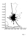
- FIG. 1 shows a coordinate system for position coordinates, which is determined on the basis of signals from a GPS system 7 at a GPS receiver 9.
- a surface VG is defined, which represents a so-called virtual gantry.
- This area VG may correspond to a geographical area and represent, for example, access to a toll area, such as a city or a highway.
- FIG. 2 shows the result which can be achieved with the method according to the invention.
- the result of the method according to the invention reflects the actual condition, namely the stationary behavior of the receiver for three days, much more accurately.
- the position detection is used for a toll collection system
- a one-off charging is applied in the method according to the invention.
- the toll system would falsely charge a fee several times, which is also referred to as multiple charging or static charging.
- FIG. 3 schematically shows an admissibility range 1 for a fix F ', which is obtained in time after a fix F.
- the illustrated admissibility range 1 applies for low speeds in the fix F ', in particular for speeds below a speed threshold value.
- a fix F ' which lies in the immediate vicinity of the previously received fix F', may be valid. This represents the so-called Kriechfall, in which a vehicle moves at very low speed.
- the admissibility range 1 is restricted to an angular range 2 ⁇ which is around the direction of travel 5 of the vehicle the first fix F lies.
- FIG. 4 shows a corresponding validity range 1 for a fix F ', which is taken in time after the fix F and in which there is a speed above the minimum speed. At this speed, a creeping behavior of the vehicle is excluded, so that the angular range around the direction of travel 5 in the immediate vicinity of the fix F does not belong to the admissibility range 1.
- a fix F ' which is detected at a speed below the minimum speed or at a higher speed, is recognized as permissible, although it lies outside the admissibility range 1 shown in FIGS. 3 and 4, in particular one greater distance than the maximum distance 4 to the fix F has. This is the case when the speed of the previously recorded fix F is greater than the minimum speed. As a result, a temporary shielding of the receiver, which is the case in particular during a tunnel journey, is taken into account. If the recorded fix F corresponds to the last fix taken before entering the tunnel, then the next fix F 'that is detected will be the first fix available after leaving the tunnel. This fix F 'will, however, usually lie outside the range of admissibility 1 defined for normal driving. Since the speed of the fix F at the entrance to the tunnel is above the minimum speed, this situation can be detected and the fix lying outside the admissibility range 1 can be recognized as permissible or at least valid.
- the verification of the affiliation of a fix F 'to an admissibility range 1 and the consideration of the speed as well as other factors can be carried out in a system shown schematically in FIG.
- the system 6 hereby comprises a position determination system 7, which as a rule comprises a number of satellites. These are at least partially in contact with an on-board unit (OBU) 8. From the position detection system 7, in particular from its satellite, signals are output for determining the position, which is determined by the Receiving unit, that is a GPS receiver 9, can be detected.
- the OBU 8 has a receiving unit, that is to say a GPS receiver 9, for receiving the signals for position detection, as well as for determining position coordinates and further attributes from these signals.
- the OBU 8 has a comparison unit 10, which is connected to a memory unit 11 in which, for example, indications for threshold values can be stored.
- the output of the OBU 8 is connected to a charging system 12, in particular a central computer unit. It is also possible according to the invention to design the receiver 9 and the OBU 8 separately. In this case, however, the two devices are connected to each other for data transmission.
- This information may be processed in the billing system 12 and, in particular, used as the basis for determining applicable charges.
- a valid fix is considered recognized only if the HDOP value is less than a given maximum HDOP value. Considering the HDOP value ensures that the fix has a certain quality. As a result, fixes that are due to an unfavorable satellite constellation or reflections and have a lower accuracy can be suppressed.
- the distance between two fixes must be less than or equal to a given maximum distance. If this is not the case, then the speed of the last fix must be greater than the predetermined minimum speed to determine the validity of the fix. As a result, tunnel passages and temporary fixed losses in underpasses are taken into account.
- the threshold which must not exceed the distance between two successive fixes, depends on the speed. Thus, outliers can be suppressed.
- the speed dependence adapts the sensitivity to the signal / noise ratio.
- Another information which can be determined by the method according to the invention and transmitted to a downstream toll system is whether the position information of the fix can be used, in particular whether the new position data should replace the old position data.
- a software standstill detection can be generated. This can be applied to a so-called hardware standstill detection, that is put on. While in hardware standstill detection only the criterion of whether the speed and the angle of the receiver are equal to zero is used as the criterion, in the method according to the invention the result becomes more reliable.
- This test also takes into account the HDOP value and ensures that the fix has a certain quality. As a result, fixes that are due to an unfavorable satellite constellation or reflections and have a lower accuracy can be suppressed.
- the new position is checked whether the new position lies within a defined ring area around the previously detected fix, whereby the speed of the last valid fix must be greater than the minimum speed.
- the new position may only be outside the defined ring range if the speed of the last valid fix is greater than the minimum speed. This takes into account the tunnel problem described above.
- a signal for overwriting is generated only when a distance below the minimum speed ("creep") was covered with low angular deviation of the individual valid fixes among each other, which is above a creep threshold of z. B. 50m is located. This avoids that the position is held in a crawl, in which always falls below the minimum speed.
- the hardware standstill detection is taken into account. If this is not activated, ie the angle of the receiver (course) and the speed of the receiver (speed) are detected as non-zero, the signal that the position data can be overwritten is generated on fulfillment of the other criteria. Since both the speed and the course can be zero after a tunnel, the check for any tunnel problems is additionally carried out. During a tunnel trip, the position data can thus be overwritten even in the case of supposedly activated hardware standstill detection.
- Another information which is determined according to the invention alternatively or additionally for the verification of the usability, is whether on the one hand a new direction of travel angle can be calculated and on the other hand whether the angle of the GPS receiver (course) is valid. It avoids this by giving an invalid angle of 0 ° or a nonsensical angle at quasi-stop to a downstream system. For this a number of conditions are checked.
- the HDOP value is taken into account, ensuring that the fix has a certain quality. This allows fixes due to a unfavorable satellite constellation or reflections have occurred and have a lower accuracy, be suppressed.
- the minimum speed must be exceeded. This avoids that an angle is calculated from heavily noisy coordinates.
- the hardware standstill detection is not activated, ie neither the angle nor the speed of the receiver is zero. As a result, the case of the stoppage of the vehicle is excluded, in which there is no change in position and thus no angle change.
- the new position must lie within the defined ring area, whereby the speed must be greater than the minimum speed.
- the new position may only be outside the defined ring area if the speed of the last valid fix is greater than the minimum speed (tunnel problem)
- the creep distance is the sum of the distances of the individual valid GPS fixes. However, the sum is reset to zero under the following conditions.
- the indicated logical conditions are not necessarily executed sequentially. Rather, they are linked together in such a way that individual comparison intermediate results are used in several logical conditions.
- the results of the checks in particular the information on the validity of a fix and its usability can be transmitted as signals to a downstream toll system as input variables.
- the present invention it is possible to improve the integrity of GPS fixes by taking into account a number of circumstances.
- the problem of shielding a GPS antenna, for example in a tunnel, moving the vehicle at a slow speed, the so-called creep, a quasi-stoppage, the speed of the vehicle and environmental disturbances can be taken into account.
- a plausibility check is carried out, which consists of logical conditions.
- the position coordinates are filtered using additional GPS attributes such as speed and course as well as information such as HDOP. Invalid coordinates are discarded, GPS-typical noise at standstill and jumps by changing satellites are removed.
- the present invention provides the possibility of simple data processing by logical conditions. A complex filter calculation as with sensor fusion can be omitted and an additional sensor hardware is not necessary.
Abstract
Description
Die vorliegende Erfindung betrifft ein Verfahren und ein System zur Ermittlung von Positionsdaten eines Objektes.The present invention relates to a method and a system for determining position data of an object.
Zur Verfolgung der Position von Objekten, insbesondere von Fahrzeugen, ist es bekannt ein satellitengestütztes Verfahren zur Positionsortung zu verwenden. Insbesondere ist die Verwendung eines Global Positioning Systems (GPS) bekannt, bei dem in oder an dem Fahrzeug ein GPS-Empfänger vorgesehen ist.For tracking the position of objects, in particular of vehicles, it is known to use a satellite-based method for position location. In particular, the use of a Global Positioning System (GPS) is known in which a GPS receiver is provided in or on the vehicle.
Die so erhaltenen Positionsdaten, die bei einem GPS-System auch als Fix bezeichnet werden, können zu unterschiedlichen Zwecken verwendet werden. So ist es möglich diese Positionsdaten einem Navigationssystem zuzuführen, diese als Eingangsgröße für ein Gebührensystem für die Ermittlung einer Streckennutzungsgebühr (Mautsystem) oder einer Überwachung der Befahrung eines Gebietes aus demoskopischen Gründen zu verwenden.The position data thus obtained, which are also referred to as fix in a GPS system, can be used for different purposes. Thus, it is possible to supply these position data to a navigation system, to use this as an input for a fee system for the determination of a route toll (toll system) or a monitoring of the driving of an area for demographic reasons.
Bei diesen Anwendungen ist es notwendig eine Ruheposition eines Fahrzeuges zuverlässig erkennen zu können, um beispielsweise bei einem Mautsystem eine mehrfache Gebührenerhebung bei Stillstand des Fahrzeuges zu vermeiden. Auch bei einem Navigationssystem ist die zuverlässige Erkennung der Ruheposition von besonderer Bedeutung, da die unterschiedlichen Ortungssignale in diesem Zustand abgeglichen werden. Um den Ruhezustand zu erkennen, werden Gyrosensoren, Beschleunigungssensoren oder Bildverarbeitungssensoren verwendet.In these applications, it is necessary to be able to reliably detect a rest position of a vehicle in order, for example, to avoid a multiple toll collection when the vehicle is at a standstill in the case of a toll system. Even with a navigation system, the reliable detection of the rest position is of particular importance, since the different locating signals are adjusted in this state. To detect hibernation, gyroscopes, accelerometers, or vision sensors are used.
In der DE 100 10 607 A1 ist beispielsweise ein Navigationssystem beschrieben, das eine Empfangs- und Auswerteeinheit für Satellitensignale zur Positionsbestimmung aufweist. Für die Unterscheidung zwischen einem Bewegungszustand und einem Ruhezustand des Fahrzeuges wird ein, in dem Fahrzeug angeordneter Sensor verwendet. Dieser Sensor kann ein Richtungssensor, zum Beispiel in Form eines Drehratensensors, sein. Bei diesem Navigationssystem wird die Unterscheidung zwischen einem Ruhezustand und einem Bewegungszustand durchgeführt, indem das Rauschen des Sensorsignals als Unterscheidungskriterium verwendet wird.In DE 100 10 607 A1, for example, a navigation system is described which includes a receiving and evaluating unit for satellite signals for position determination having. For discriminating between a moving state and a resting state of the vehicle, a sensor disposed in the vehicle is used. This sensor can be a direction sensor, for example in the form of a rotation rate sensor. In this navigation system, the distinction between a sleep state and a move state is made by using the noise of the sensor signal as a discrimination criterion.
Die Systeme des Standes der Technik weisen die Nachteile auf, dass zusätzlich zu dem GPS-System eine Sensor-Hardware bereitgestellt werden muss, der Sensor in das System integriert werden muss und dessen Daten gesondert verarbeitet werden müssen. Es entsteht ein zusätzlicher Aufwand aufgrund der durchzuführenden Sensorfusion, die durch Verwendung eines Kalman-Filters realisiert werden kann.The prior art systems have the disadvantages that in addition to the GPS system, sensor hardware must be provided, the sensor must be integrated into the system and its data must be separately processed. There is an additional expense due to the sensor fusion to be performed, which can be realized by using a Kalman filter.
Der vorliegenden Erfindung liegt somit die Aufgabe zugrunde ein Verfahren und ein System zu schaffen, bei dem die Integrität der Erfassungswerte eines satellitengestützten Ortungssystems für bestimmte Anwendungen, wie beispielsweise Navigationssysteme und/oder Mautsysteme, erhöht werden kann.It is an object of the present invention to provide a method and a system in which the integrity of the detection values of a satellite-based location system can be increased for specific applications, such as navigation systems and / or toll systems.
Der Erfindung liegt die Erkenntnis zugrunde, dass diese Aufgabe gelöst werden kann, indem Kriterien zur Erhöhung der Integrität verwendet werden, die von dem satellitengestützten System selber bereit gestellt werden.The invention is based on the finding that this object can be achieved by using criteria for increasing the integrity that are provided by the satellite-based system itself.
Die Aufgabe wird somit gelöst durch ein Verfahren gemäß den Merkmalen des Anspruchs 1 und ein System mit den Merkmalen des Anspruchs 16. Weiterbildungen der Erfindung und bevorzugte Ausführungsformen sind Gegenstand der Unteransprüche.The object is thus achieved by a method according to the features of
Vorteile und Merkmale, die bezüglich des erfindungsgemäßen Verfahrens beschrieben werden gelten -soweit anwendbar- auch für das erfindungsgemäße System und umgekehrt.Advantages and features that are described with respect to the method according to the invention apply - as far as applicable - also for the system according to the invention and vice versa.
Gemäß einem ersten Aspekt der Erfindung betrifft diese ein Verfahren zur Ermittlung von Positionsdaten eines Objekts, bei dem Signale zur Positionsermittlung von einem Positionsermittlungs-System an einen, dem Objekt zugeordneten, Empfänger übermittelt werden, wo aus den erfassten Signalen Positionsangaben ermittelt werden. Das Verfahren zeichnet sich dadurch aus, dass die an den Empfänger ermittelten Positionsangaben einer Prüfung unterzogen werden, wobei zumindest ein Attribut des Empfängers als Prüfungskriterium verwendet wird und der Wert des mindestens einen Attributes mit mindestens einem Grenzwert verglichen wird.According to a first aspect of the invention, this relates to a method for determining position data of an object, in which signals for position detection are transmitted by a position-determining system to a receiver assigned to the object, where position information is determined from the detected signals. The method is characterized in that the position information determined at the receiver is subjected to a test, wherein at least one attribute of the receiver is used as a test criterion and the value of the at least one attribute is compared with at least one limit value.
Ein Objekt im Sinne dieser Erfindung ist insbesondere ein Fahrzeug, vorzugsweise ein Kraftfahrzeug. Als Attribute des Empfängers werden im Sinne der Erfindung solche Angaben bezeichnet, die außer der reinen Positionsangabe in Form von Koordinaten aus den von dem Positionsermittlungs-System an den Empfänger übertragen Signalen zur Positionsermittlung bestimmt werden können oder aus den ermittelten Positionsangaben abgeleitet werden. Die aus den Signalen zur Positionsermittlung ermittelten Positionsangaben werden im Folgenden auch als erfasste beziehungsweise ermittelte Positionsangaben bezeichnet. Zu jeder Positionsangabe liegt der Wert der Attribute vor oder kann abgeleitet werden. Als Attribute können somit beispielsweise die Geschwindigkeit des Empfängers (speed) und/oder der Winkel des Empfängers (course) verwendet werden. Ein weiteres Attribut kann beispielsweise der räumliche Abstand zwischen erfassten Positionen sein, die im Folgenden als Fixes bezeichnet werden. Schließlich können als weitere Attribute weitere Richtungsangaben des Empfängers, die abgeleitete Größen darstellen, verwendet werden. Insbesondere können der Sollkurs, die Bewegungsrichtung und/oder der Winkel zwischen den Bewegungsrichtungen des Empfängers in zwei Positionen des Empfängers Attribute sein.An object in the sense of this invention is in particular a vehicle, preferably a motor vehicle. Within the meaning of the invention, such attributes are referred to as attributes of the receiver which, in addition to the pure position information in the form of coordinates, can be determined from the signals transmitted by the position-finding system to the receiver for determining the position or are derived from the determined position information. The position information determined from the signals for determining the position are also referred to below as detected or determined position information. For every position specification, the value of the attributes is available or can be derived. Thus, for example, the speed of the receiver (speed) and / or the angle of the receiver (course) can be used as attributes. Another attribute may be, for example, the spatial distance between detected positions, which are referred to below as fixes. Finally, as further attributes further directional information of the receiver, which represent derived variables, can be used. In particular, the desired course, the direction of movement and / or the angle between the directions of movement of the receiver in two positions of the receiver can be attributes.
Durch den Vergleich des Wertes eines Attributs mit mindestens einem Grenzwert, kann das Erfüllen einer vorgebbaren Bedingung überprüft werden. Für diesen Vergleich sind keine Werte erforderlich, die von weiteren Sensoren erfasst werden müssen. Vielmehr werden für den Vergleich Attribute verwendet, die aus den Signalen des Positionsermittlungssystems an dem Empfänger ermittelt werden. Das erfindungsgemäße Verfahren bietet somit ein integrales System, bei dem insbesondere eine Sensorfusion nicht notwendig ist, wodurch das Verfahren gegenüber dem Stand der Technik wesentlich vereinfacht ist. Zudem können die Attribute des Empfängers stets zuverlässig einer Positionsangabe zugeordnet werden, so dass eine separate Zuweisung entfallen kann und die Überprüfung dennoch den tatsächlich vorliegenden Gegebenheiten Rechnung trägt.By comparing the value of an attribute with at least one limit value, the fulfillment of a predefinable condition can be checked. For this comparison, no values are required, which must be recorded by other sensors. Rather, the comparison uses attributes from the Signals of the position detection system are determined at the receiver. The method according to the invention thus offers an integral system in which, in particular, sensor fusion is not necessary, as a result of which the method is considerably simplified in comparison to the prior art. In addition, the attributes of the recipient can always be reliably assigned to a position specification, so that a separate assignment can be omitted and the review still takes into account the facts actually present.
Zudem hat sich gezeigt, dass bei Verwendung von Attributen des Empfängers nicht nur zwischen einem Bewegungszustand und einem Ruhezustand unterschieden werden kann, das heißt eine reine Stillstandserkennung, durchgeführt werden kann, sondern zudem die Genauigkeit der Stillstandserkennung und die Integrität der Positionsdaten erhöht werden kann, da eine Reihe weiterer zusätzlicher Umstände berücksichtigt werden können. So können beispielsweise die Abschirmung eines GPS-Empfängers beziehungsweise einer GPS-Antenne, die bei einer Tunnelfahrt auftreten kann, ein sehr langsames Bewegen des Objektes, sowie das typische GPS-Rauschen beim Stillstand eines Objektes und Ausreißer adressiert werden.In addition, it has been shown that when using attributes of the receiver not only a movement state and a rest state can be distinguished, that is, a pure standstill detection, can be performed, but also the accuracy of the standstill detection and the integrity of the position data can be increased because a number of other additional circumstances can be taken into account. Thus, for example, the shielding of a GPS receiver or a GPS antenna, which can occur during a tunnel drive, a very slow moving of the object, and the typical GPS noise at standstill of an object and outliers can be addressed.
Gemäß einer bevorzugten Ausführungsform werden die Positionsangaben in Abhängigkeit des Überprüfungsergebnisses gefiltert. Dies bedeutet, dass nur die Positionsangaben, die die durch den Schwellwert oder andere Prüfungskriterien festgelegten Bedingungen erfüllen, als zulässig, gültig und/oder verwendbar erkannt werden, während die Positionsangaben, die zu einem negativen Prüfergebnis führen, gegebenenfalls verworfen werden. Die als zulässig, gültig und/oder verwendbar erkannten Positionsangaben können alleine oder mit zusätzlichen Informationen für eine weitere Verwendung zur Verfügung gestellt werden. Diese weitere Verwendung kann ein nachfolgender Überprüfungsschritt oder aber eine Verarbeitung in einem nachgeschalteten Verfahren, wie einem Navigationssystem oder einem Mauterhebungssystem, sein. Durch die Filterung wird die Integrität der den Filter passierenden Positionsangaben gewährleistet und dadurch das Ergebnis eines nachgeschalteten Systems, für das die Positionsangaben als Eingangsgrößen dienen, verbessert.According to a preferred embodiment, the position information is filtered depending on the result of the check. This means that only the position information that satisfies the conditions defined by the threshold or other test criteria is recognized as valid, valid and / or usable, while the position information leading to a negative test result may be discarded. The position information recognized as valid, valid and / or usable can be provided on its own or with additional information for further use. This further use may be a subsequent verification step or a processing in a downstream process, such as a navigation system or a toll collection system. Through the filtering, the integrity of the position information passing through the filter is ensured and thereby the result of a Downstream system, for which the position information is used as input, improved.
Als zulässig wird eine Positionsangabe erachtet, wenn diese alle Erfordernisse, die vorgegeben sind erfüllt. Insbesondere sind solche Positionsangaben gültig und verwendbar. Eine gültige Positionsangabe kann zumindest dazu verwendet werden die Erfassung einer Position zu registrieren. Als gültig gilt eine Positionsangabe insbesondere dann, wenn diese eine gewisse Qualität aufweist und zudem einen vorgebbaren Maximalabstand zu einer zuvor erfassten Positionsangabe nicht überschreitet. Als verwendbar wird eine Positionsangabe bezeichnet, wenn diese ihren Eigenschaften nach dazu geeignet ist als Eingangsgröße für weitere Berechnungen des Verfahrens oder eines nachgeschalteten Systems zu dienen.A position specification is considered permissible if it fulfills all requirements that are specified. In particular, such position information is valid and usable. A valid position indication can at least be used to register the detection of a position. A position specification is valid, in particular, if it has a certain quality and, moreover, does not exceed a predefinable maximum distance to a previously recorded position specification. A position indication is designated as usable if, according to its properties, it is suitable for serving as an input variable for further calculations of the method or of a downstream system.
Vorzugsweise werden in dem Überprüfungsschritt die Werte von mindestens zwei Attributen mit Grenzwerten verglichen. Auch in diesem Fall werden die Werte aufgrund des Vergleichsergebnisses gefiltert. Die Vergleiche der mindestens zwei Werte können simultan oder nacheinander erfolgen.Preferably, in the checking step, the values of at least two attributes are compared with thresholds. Also in this case, the values are filtered based on the comparison result. The comparisons of the at least two values can be made simultaneously or sequentially.
Der Vorteil des Vergleiches von mehr als einem Wert mit einem Grenzwert liegt darin, dass hierdurch unterschiedlichen Situationen Rechnung getragen werden kann. Insbesondere kann auch der Schwellwert eines zweiten Vergleichsschrittes unter Berücksichtigung des Ergebnisses des ersten Vergleichs festgelegt werden.The advantage of comparing more than one value with a threshold is that it allows different situations to be taken into account. In particular, the threshold value of a second comparison step can also be determined taking into account the result of the first comparison.
Weiterhin kann auch die Zugehörigkeit des Wertes des oder der Attribute zu einem Bereich überprüft werden, der weder bei Null beginnt noch im Unendlichen endet. Hierzu wird der Wert mit zwei Schwellwerten verglichen, wobei einer einen Maximalwert und ein weiterer einen Minimalwert darstellt. Ein solcher Bereich kann aufgrund von weiteren Kriterien festgelegt werden. Beispielsweise kann ein Gültigkeitsbereich für den Abstand, das heißt die räumliche Entfernung, zweier Fixes zueinander für eine gegebene Geschwindigkeit des Objektes angegebene werden. Hierdurch können durch den Minimalwert insbesondere das Rauschen bei Stillstand und durch den Maximalwert so genannte Ausreißer erkannt und gegebenenfalls eliminiert, das heißt ausgefiltert werden.Furthermore, the affiliation of the value of the attribute or attributes to an area can be checked, which does not start at zero or ends at infinity. For this purpose, the value is compared with two threshold values, one representing a maximum value and another a minimum value. Such an area can be determined on the basis of further criteria. For example, a scope for the distance, that is, the spatial distance, of two fixes to each other for a given speed of the object can be specified. As a result, by the minimum value in particular the noise at standstill and detected by the maximum value so-called outliers and optionally eliminated, that is filtered out.
Es ist erfindungsgemäß auch möglich, dass der Schwellwert für ein Attribut in Abhängigkeit mindestens eines weiteren Attributes bestimmt wird. So kann beispielsweise der Schwellwert für einen Abstand zwischen Fixes oder für einen Winkel zu der Fahrtrichtung in Abhängigkeit der Geschwindigkeit des Empfängers festgelegt werden. Bei höherer Geschwindigkeit wird beispielsweise zwischen zwei nacheinander empfangenen Fixes ein größerer Abstand bestehen als bei niedrigen Geschwindigkeiten. Die Berücksichtigung der Geschwindigkeit oder eines anderen Attributes bei der Festlegung des Schwellwertes, bringt den Vorteil mit sich, dass die Angaben den tatsächlichen Bedingungen angepasst sind und so die Genauigkeit der Ergebnisse und deren Repräsentativität gesteigert werden.It is also possible according to the invention that the threshold value for an attribute is determined as a function of at least one further attribute. For example, the threshold may be set for a distance between fixes or for an angle to the direction of travel depending on the speed of the receiver. At higher speeds, for example, there will be a greater distance between two successive received fixes than at low speeds. Taking the speed or other attribute into account when setting the threshold has the advantage of tailoring the information to the actual conditions, thus increasing the accuracy of the results and their representativeness.
Der Wert mindestens eines Attributs wird in einer Ausführungsform aus zeitlich zuvor erfassten Positionsangaben ermittelt. Hierbei kann vorzugsweise die zuvor erfasste Positionsangabe mir der aktuellen Positionsangabe verarbeitet werden. So kann beispielsweise die Fahrrichtung beziehungsweise die Bewegungsrichtung oder der Abstand aus den Positionsangaben ermittelt werden. Die zeitlich zuvor erfassten Positionsangaben und Attribute des Empfängers in dieser Position können in einem Speicher abgelegt sein, um für die Verarbeitung zur Verfügung zu stehen.The value of at least one attribute is determined in one embodiment from previously recorded position information. In this case, the previously recorded position information can preferably be processed with the current position specification. For example, the direction of travel or the direction of movement or the distance from the position information can be determined. The position information and attributes of the receiver previously recorded in this position can be stored in a memory in order to be available for processing.
In der Regel werden die Werte eines Attributes eines aktuellen Fixes mit den vorgegebenen Schwellwerten verglichen. Es ist aber auch möglich zumindest einen Wert eines Attributes eines zeitlich zuvor erfassten Fixes mit einem Schwellwert zu vergleichen. So kann beispielsweise die Geschwindigkeit eines zuvor erfassten Fixes mit einem Schwellwert, insbesondere einem Minimalwert verglichen werden. Hieraus ergibt sich, dass sich das Fahrzeug in der letzten erfassten Position bewegt hat. Diese Information ist für die Beurteilung ob ein Fahrzeug beispielsweise einen Tunnel befahren hat von Bedeutung. In diesem Fall wird nämlich der Abstand zwischen zwei zeitlich aufeinander folgenden Fixes sehr groß sein. War die Geschwindigkeit bei dem ersten Fix gleich Null, so ist in der Regel in diesem Fall von einem fehlerhaften Wert, einem so genannten Ausreißer auszugehen. Hat sich das Fahrzeug allerdings bewegt, so kann von einer Tunnelfahrt ausgegangen werden.As a rule, the values of an attribute of a current fix are compared with the specified thresholds. However, it is also possible to compare at least one value of an attribute of a previously recorded fix with a threshold value. Thus, for example, the speed of a previously detected fix can be compared with a threshold value, in particular a minimum value. It follows that the vehicle has moved in the last detected position. This information is important for the assessment of whether a vehicle has traveled through a tunnel, for example. In this case, namely, the distance between two temporally successive fixes will be very large. Was the Speed at the first fix equal to zero, it is generally assumed in this case of an erroneous value, a so-called outlier. However, if the vehicle has moved, it can be assumed that the tunnel has been driven.
Zusätzlich zu dem mindestens einem Attribut des Empfängers wird mindestens eine Angabe bezüglich der Satellitenübertragung, insbesondere eine Verschlechterung der Genauigkeit (dilution of precision DOP), für die Prüfung verwendet. Besonders bevorzugt wird die HDOP (horizontal dilution of precision) betrachtet. Die Satellitenübertragung kann durch eine ungünstige Satellitenkonstellation, Reflexionen von Satellitensignalen, der Abschirmung eines oder mehrerer Satelliten gegenüber dem Empfänger gestört sein. Diese Störungen können teilweise durch Hindernisse, wie Bauwerke oder auch Umwelteinflüsse, wie beispielsweise nasses Laub, hervorgerufen werden.In addition to the at least one attribute of the receiver, at least one indication relating to the satellite transmission, in particular a dilution of precision DOP, is used for the test. Particularly preferred is the HDOP (horizontal dilution of precision) considered. The satellite transmission may be disturbed by an unfavorable satellite constellation, reflections from satellite signals, the shielding of one or more satellites from the receiver. These disturbances can be caused in part by obstacles, such as buildings or even environmental influences, such as wet leaves.
Mit dem erfindungsgemäßen Verfahren wird insbesondere ermittelt, ob die erfasste Positionsangabe eine gültige Positionsangabe darstellt. Ob der aufgrund der Signale von dem Positionsermittlungssystem an dem Empfänger ermittelte Fix eine gültige Angabe darstellt, kann bei dem erfindungsgemäßen Verfahren unter Berücksichtigung einer Anzahl von Einflüssen und Bedingungen ermittelt werden. Insbesondere wird die Satellitenübertragung berücksichtigt und weiterhin ein maximaler Abstand zwischen aufeinander folgenden Fixes gefordert. Hierdurch können Ausreißer eliminiert werden.The method according to the invention determines, in particular, whether the detected position information represents a valid position specification. Whether the fix determined on the basis of the signals from the position detection system at the receiver is a valid indication can be determined in the method according to the invention taking into account a number of influences and conditions. In particular, the satellite transmission is taken into account and further demands a maximum distance between successive fixes. As a result, outliers can be eliminated.
Weiterhin kann in der Prüfung kontrolliert werden, ob die Positionsangabe verwendbar ist. Hierbei können zwei Aspekte berücksichtig werden. Bei dem ersten Aspekt wird überprüft, ob eine zuvor erfasste Positionsangabe mit einer aktuellen Positionsangabe überschrieben werden kann. Das Ergebnis dieser Entscheidung kann als Signal an ein dem Empfänger nachgeschaltetes System beispielsweise ein Gebührenermittlungssystem weitergeleitet werden. Für diese Entscheidung wird berücksichtigt, ob der Fix einen gültigen Fix darstellt, das heißt eine gewisse Qualität aufweist und einen Maximalabstand zu einem vorhergehenden Fix nicht überschreitet. Weiterhin wird bei dieser Prüfung auch berücksichtigt, dass sich das Fahrzeug gegebenenfalls bei einer sehr geringen Geschwindigkeit bewegen kann und bei GPS-Signalen, aufgrund von Rauschen, Fixes ohne Bewegung des Empfängers leicht voneinander abweichen. Schließlich kann auch eine zeitweilige Abschirmung beziehungsweise Abschattung des Empfängers berücksichtigt werden. Durch diese Prüfung kann sichergestellt werden, dass bei einem Fix, der zwar einen gültigen Fix darstellt, insbesondere kein Ausreißer ist, aber den tatsächlichen Zustand des Empfängers nicht wiedergibt, nur die Angabe, dass es ein gültiger Fix vorliegt, weitergegeben wird, die neue Positionsangabe die alte Positionsangabe aber nicht ersetzt. Hierzu kann entweder nur die Angabe, dass ein gültiger Fix vorliegt aber keine Positionsangaben an nachgeschaltete Systeme übertragen werden oder das nachgeschaltete System ist so ausgelegt, dass dieses die Positionsdaten bei Empfang eines entsprechenden Signals nicht überschreibt.Furthermore, it can be checked in the check whether the position specification can be used. Two aspects can be considered here. In the first aspect, it is checked whether a previously acquired position information can be overwritten with a current position specification. The result of this decision can be forwarded as a signal to a system downstream of the receiver, for example a charging system. For this decision, it is considered whether the fix represents a valid fix, that is, has a certain quality and a maximum distance to a previous fix not exceeds. Furthermore, this test also takes into account that the vehicle may possibly move at a very low speed and slightly deviate from one another in GPS signals, due to noise, fixes without movement of the receiver. Finally, a temporary shielding or shadowing of the receiver can be taken into account. This check ensures that if the fix is a valid fix, not an outlier in particular, but does not reflect the actual state of the recipient, only the indication that there is a valid fix is passed, the new position specification but the old position information is not replaced. For this purpose, either only the indication that a valid fix is present but no position information is transmitted to downstream systems or the downstream system is designed so that this does not overwrite the position data upon receipt of a corresponding signal.
Als weiterer Aspekt der Verwendbarkeit der Positionsdaten kann zusätzlich oder alternativ kontrolliert werden, ob die erfassten Positionsangaben für die Ermittlung weiterer Werte von Attributen verwendet werden können. Hierdurch kann bereits im Vorfeld sichergestellt werden, dass Werte, die nicht repräsentativ sind, nicht als Grundlage für die Berechnung verwendet werden. Hierdurch wird das Ergebnis der weiteren Verarbeitung verbessert. Auch für nachgeschaltete Systeme, wie Mautsysteme kann diese Information von Bedeutung sein, damit auch in diesen nur repräsentative Werte als Eingangsgrößen verwendet werden. Besonders bevorzugt betrifft diese Prüfung richtungsabhängige Attribute. Insbesondere wird überprüft, ob eine neue Bewegungsrichtung des Empfängers berechnet werden kann und ob der Winkel des Empfängers gültig ist. Im Stillstand des Fahrzeuges oder bei zu geringem Abstand zwischen zwei Positionen ist beispielsweise eine Berechnung der Bewegungsrichtung des Empfängers nicht möglich beziehungsweise würden zu falschen Ergebnissen führen. Dem kann durch die beschriebene Überprüfung vorgebeugt werden.As a further aspect of the usability of the position data, it can be additionally or alternatively checked whether the detected position information can be used to determine further values of attributes. This makes it possible to ensure in advance that values which are not representative are not used as the basis for the calculation. This improves the result of further processing. This information can also be important for downstream systems such as toll systems, so that only representative values are used as input variables in these systems as well. Particularly preferably, this check relates to direction-dependent attributes. In particular, it is checked whether a new direction of movement of the receiver can be calculated and whether the angle of the receiver is valid. When the vehicle is at a standstill or if the distance between two positions is too short, for example, a calculation of the direction of movement of the receiver is not possible or would lead to incorrect results. This can be prevented by the described review.
Gemäß einem weiteren Aspekt betrifft die Erfindung ein System zur Ermittlung von Positionsdaten eines Objekts, wobei das System zumindest einen Empfänger zum Empfang von Signalen zur Positionsermittlung von einem satellitenbasierten Positionsermittlungs-System und zur Ermittlung von Positionsangaben aufweist. Das System zeichnet sich dadurch aus, dass dieses eine Erkennungseinheit zum Erkennen des Stillstandes eines Objekts aufweist, wobei die Erkennungseinheit dem Empfänger zugeordnet ist. Der Empfänger, der insbesondere einen GPS-Receiver darstellt, kann mit der Erkennungseinheit in einem Steuergerät eines Gebührenerfassungssystems, insbesondere einer so genannten On-Board-Unit (OBU) zusammengefasst sein. Es ist aber auch möglich die OBU und den Empfänger als separate Geräte auszubilden.According to a further aspect, the invention relates to a system for determining position data of an object, wherein the system has at least one receiver for receiving signals for determining the position of a satellite-based position-determining system and for determining position information. The system is characterized in that it has a detection unit for detecting the stoppage of an object, wherein the detection unit is assigned to the receiver. The receiver, which in particular represents a GPS receiver, can be combined with the recognition unit in a control unit of a toll collection system, in particular a so-called on-board unit (OBU). But it is also possible to form the OBU and the receiver as separate devices.
Die Stillstandserkennungseinheit kann in dem Empfänger enthalten, das heißt in diesen integriert sein und insbesondere ein Programm darstellt. Somit wird eine software-basierte Stillstandserkennung geschaffen. Die Stillstandserkennungseinheit kann aber auch in einem Steuergerät eines Mautsystems, insbesondere in einer so genannten On-Board-Unit (OBU) enthalten sein.The standstill detection unit can be contained in the receiver, that is to say integrated in it, and in particular represents a program. Thus, a software-based standstill detection is created. However, the standstill detection unit can also be contained in a control unit of a toll collection system, in particular in a so-called on-board unit (OBU).
Die Erkennungseinheit umfasst vorzugsweise eine Vergleichseinheit, wobei die Vergleichseinheit zur Bestimmung der Zugehörigkeit von Positionsangaben zu einem vorgegebenen Bereich dient.The recognition unit preferably comprises a comparison unit, wherein the comparison unit is used to determine the affiliation of position information to a predetermined area.
Das erfindungsgemäße System weist vorzugsweise eine Schnittstelle, insbesondere eine Luftschnittstelle, zu einem Mauterhebungssystem auf. Über diese Schnittstelle können Positionskoordinaten sowie Signale betreffend die Relevanz eines Fixes übertragen werden. Die Signale betreffend die Relevanz des Fixes können beispielsweise die Angabe über dessen Gültigkeit und Verwendbarkeit für nachfolgende Berechnungen umfassen.The system according to the invention preferably has an interface, in particular an air interface, to a toll collection system. Position coordinates and signals concerning the relevance of a fix can be transmitted via this interface. The signals concerning the relevance of the fix may include, for example, the indication of its validity and usability for subsequent calculations.
Die übermittelten Daten können in dem Mauterhebungssystem als Eingangsgrößen verwendet werden und liefern insbesondere Positionskoordinaten mit denen eine zuverlässige Erkennung von GeoObjekten, wie beispielsweise Virtual Gantries, erzielt werden kann. Solche GeoObjekte sind in der Regel durch eine Fläche in einem Koordinatensystem definiert und können beispielsweise im Bereich von Positionskoordinaten hinterlegt sein, bei denen eine Auffahrt auf einen gebührenpflichtigen Streckenabschnitt liegt.The transmitted data can be used as input variables in the toll collection system and in particular provide position coordinates with which Reliable detection of Geo objects, such as Virtual Gantries, can be achieved. Such GeoObjekte are usually defined by an area in a coordinate system and can be deposited, for example, in the range of position coordinates in which a driveway is on a toll road section.
Die Erfindung wird im Folgenden anhand der beiliegenden Figuren erneut erläutert.
Es zeigen:
- Figur 1: eine schematische Darstellung von GPS-Fixes in einem KoordinatenSystem, die nach dem Stand der Technik erfasst wurden;
- Figur 2: eine schematische Darstellung von GPS-Fixes in einem KoordinatenSystem, die nach einer Ausführungsform der vorliegenden Erfindung erfasst wurden;
- Figur 3: eine schematische Darstellung eines Gültigkeitsbereiches für Fixes für eine erste Geschwindigkeit des Empfängers;
- Figur 4: eine schematische Darstellung eines Gültigkeitsbereiches für Fixes für eine zweite Geschwindigkeit des Empfängers; und
- Figur 5: eine schematische Darstellung einer Ausführungsform des erfindungsgemäßen Systems.
Show it:
- Figure 1 is a schematic representation of GPS fixes in a coordinate system, which have been detected in the prior art;
- Figure 2 is a schematic representation of GPS fixes in a coordinate system acquired in accordance with an embodiment of the present invention;
- Figure 3 is a schematic representation of a range of validity for fixes for a first speed of the receiver;
- Figure 4 is a schematic representation of a range of validity for fixes for a second speed of the receiver; and
- Figure 5: a schematic representation of an embodiment of the system according to the invention.
In Figur 1 ist ein Koordinatensystem für Positionskoordinaten dargestellt, die aufgrund von Signalen von einem GPS-System 7 an einem GPS-Empfänger 9 ermittelt werden. In diesem Koordinatensystem ist eine Fläche VG definiert, die ein so genanntes Virtual Gantry darstellt. Diese Fläche VG kann einem geographischen Bereich entsprechen und beispielsweise die Zufahrt in einen gebührenpflichtigen Bereich, wie eine Stadt oder auf eine Autobahn, repräsentieren. Werden GPS-Fixes F mit einem System nach dem Stand der Technik, das heißt insbesondere ohne Verwendung des erfindungsgemäßen Verfahrens erfasst, so erhält man beim Stillstand eines Fahrzeuges für drei Tage das in Figur 1 dargestellte Ergebnis.FIG. 1 shows a coordinate system for position coordinates, which is determined on the basis of signals from a
In Figur 2 hingegen ist das Ergebnis gezeigt, das mit dem erfindungsgemäßen Verfahren erzielt werden kann. Wie sich aus Figur 2 entnehmen lässt, spiegelt das Ergebnis des erfindungsgemäßen Verfahrens die tatsächliche Bedingung, nämlich das stationäre Verhalten des Empfängers für drei Tage, wesentlich präziser wieder. Wird somit die Positionserfassung für ein Mauterhebungssystem verwendet, so erfolgt bei dem erfindungsgemäßen Verfahren zutreffend eine einmalige Gebührenerhebung. Bei einem Verfahren nach dem Stand der Technik würde das Mautsystem hingegen fälschlicher Weise mehrfach eine Gebühr erheben, was auch als Mehrfachbemautung oder Static Charging bezeichnet wird.In contrast, FIG. 2 shows the result which can be achieved with the method according to the invention. As can be seen from FIG. 2, the result of the method according to the invention reflects the actual condition, namely the stationary behavior of the receiver for three days, much more accurately. Thus, if the position detection is used for a toll collection system, a one-off charging is applied in the method according to the invention. By contrast, in a prior art method, the toll system would falsely charge a fee several times, which is also referred to as multiple charging or static charging.
In Figur 3 ist schematisch ein Zulässigkeitsbereich 1 für einen Fix F' dargestellt, der zeitlich nach einem Fix F erhalten wird. Der dargestellte Zulässigkeitsbereich 1 trifft für geringe Geschwindigkeiten bei dem Fix F', insbesondere für Geschwindigkeiten unterhalb eines Geschwindigkeitsschwellwertes zu. Wie sich aus der Figur 3 entnehmen lässt, kann bei diesen Geschwindigkeiten ein Fix F', der in unmittelbarer Nähe 2 des zuvor aufgenommenen Fixes F' liegt, gültig sein. Dies stellt den so genannten Kriechfall dar, in dem sich ein Fahrzeug mit sehr geringer Geschwindigkeit bewegt. Um aber dennoch Fixes ausschließen zu können, die aufgrund von Störungen oder dem für GPS-Systeme typischen Rauschen, erfasst würden, ist in unmittelbarer Nähe des ersten Fixes F der Zulässigkeitsbereich 1 auf einen Winkelbereich 2α beschränkt, der um die Fahrtrichtung 5, des Fahrzeuges bei dem ersten Fix F liegt. Erst ab einem unteren Grenzwert 3, der den minimalen Fixabstand beschreibt, kann der nächste Fix F' in einer beliebigen Richtung um den ersten Fix F liegen. Aufgrund der Geschwindigkeit, die für den Zulässigkeitsbereich 1 zugrunde gelegt wird, kann auch ein maximaler Abstand 4 definiert werden. Ist der Abstand zwischen Fix F und Fix F' größer als der Maximalwert 4, so ist der Fix F' ungültig.FIG. 3 schematically shows an
In der Figur 4 ist ein entsprechender Gültigkeitsbereich 1 für einen Fix F' dargestellt, der zeitlich nach dem Fix F aufgenommen wird und bei dem eine über der Mindestgeschwindigkeit liegende Geschwindigkeit vorliegt. Bei dieser Geschwindigkeit ist ein Kriechverhalten des Fahrzeuges ausgeschlossen, so dass der Winkelbereich um die Fahrtrichtung 5 in unmittelbare Nähe des Fixes F nicht zu dem Zulässigkeitsbereich 1 zählt.FIG. 4 shows a
Es ist allerdings auch möglich, dass ein Fix F', der bei einer Geschwindigkeit unterhalb der Mindestgeschwindigkeit oder bei darüber liegender Geschwindigkeit, erfasst wird, als zulässig erkannt wird, obwohl er außerhalb des in den Figuren 3 und 4 gezeigten Zulässigkeitsbereiches 1 liegt, insbesondere einen größeren Abstand, als den Maximalabstand 4 zu dem Fix F aufweist. Dies ist der Fall, wenn die Geschwindigkeit des zuvor aufgenommenen Fixes F größer als die Mindestgeschwindigkeit ist. Hierdurch kann eine zeitweilige Abschirmung des Empfängers, was insbesondere bei einer Tunnelfahrt der Fall ist, berücksichtigt werden. Entspricht der aufgenommene Fix F dem letzten vor dem Eintritt in den Tunnel aufgenommenen Fix, so wird der nächste Fix F', der erfasst wird, der erste Fix sein, der nach dem Verlassen des Tunnels verfügbar ist. Dieser Fix F' wird aber in der Regel außerhalb des für normales Fahren definierten Zulässigkeitsbereiches 1 liegen. Da die Geschwindigkeit des Fixes F bei der Einfahrt in den Tunnel über der Mindestgeschwindigkeit liegt, kann diese Situation erkannt werden und der außerhalb des Zulässigkeitsbereiches 1 liegende Fix als zulässig oder zumindest als gültig erkannt werden.However, it is also possible that a fix F ', which is detected at a speed below the minimum speed or at a higher speed, is recognized as permissible, although it lies outside the
Die Überprüfung der Zugehörigkeit eines Fixes F' zu einem Zulässigkeitsbereich 1 und die Berücksichtigung der Geschwindigkeit sowie weiterer Faktoren kann in einem in Figur 5 schematisch dargestellten System erfolgen. Das System 6 umfasst hierbei ein Positionsermittlungssystem 7, das in der Regel eine Anzahl von Satelliten umfasst. Diese stehen zumindest teilweise mit einer On-Board-Unit (OBU) 8 in Kontakt. Von dem Positionsermittlungssystem 7, insbesondere von dessen Satelliten, werden Signale zur Positionsermittlung ausgegeben, die von der Empfangseinheit, das heißt einem GPS-Empfänger 9, erfasst werden können. Die OBU 8 weist in der dargestellten Ausführungsform hierzu eine Empfangseinheit, das heißt einen GPS-Empfänger 9, für den Empfang der Signale zur Positionserkennung, sowie für die Ermittlung von Positionskoordinaten und weiteren Attributen aus diesen Signalen auf. Weiterhin weist die OBU 8 in der dargestellten Ausführungsform eine Vergleichseinheit 10 auf, die mit einer Speichereinheit 11, in der beispielsweise Angaben für Schwellwerte hinterlegt sein können, verbunden ist. Der Ausgang der OBU 8 steht in der dargestellten Ausführungsform mit einem Gebührenerfassungssystem 12, insbesondere einer zentralen Rechnereinheit, in Verbindung. Es ist erfindungsgemäß auch möglich den Empfänger 9 und die OBU 8 separat auszugestalten. In diesem Fall sind die beiden Geräte aber zur Datenübermittlung miteinander verbunden.The verification of the affiliation of a fix F 'to an
Die Angaben, die von der OBU 8 ausgegeben werden und an das Gebührenerfassungssystem 12 übermittelt werden, sind insbesondere Informationen über die Position, insbesondere die Positionskoordinaten, eine Angabe darüber ob es sich um einen gültigen Fix handelt, die Angabe ob es sich um verwendbare Fixes handelt, insbesondere ob ein vorheriger Fix überschrieben werden kann und ob ein neuer Fahrtrichtungswinkel berechnet werden kann und ob der Winkel des Empfängers gültig ist. Diese Angaben können in dem Gebührenerfassungssystem 12 verarbeitet werden und insbesondere als Basis für die Ermittlung anfallender Gebühren verwendet werden.The information that is output by the
Einige der Bedingungen, die für ein Ausführungsbeispiel des erfindungsgemäßen Verfahrens verwendet werden, werden im Folgenden genauer beschrieben.Some of the conditions used for an embodiment of the method according to the invention will be described in more detail below.
Als Bedingung für einen gültigen GPS-Fix wird zunächst die Qualität des Fixes, das heißt gegebenenfalls herrschende Einflüsse von Satellitenkonstellationen Reflexionen und dergleichen, sowie der Abstand zwischen zwei aufeinander folgenden Fixes berücksichtigt. Zur Beurteilung, ob der erfasste Fix gültig ist wird neben der reinen Positionsangabe der Fixes sowohl die Geschwindigkeit des aktuellen Fixes als auch des letzten Fixes berücksichtigt. Dies weist den Vorteil auf, dass zum einen ein geschwindigkeitsabhängiger Maximalwert für den Abstand zwischen Fixes festgelegt werden kann und gleichzeitig der Fall, einer für einen gewissen Zeitraum, beispielsweise in einem Tunnel, abgeschirmten GPS-Antenne berücksichtigt werden kann.As a condition for a valid GPS fix, first of all the quality of the fix, that is to say possibly prevailing influences of satellite constellations reflections and the like, as well as the distance between two successive fixes are considered. In order to assess whether the detected fix is valid, the velocity of the current fixes as well as the last fix. This has the advantage that, on the one hand, a speed-dependent maximum value for the distance between fixes can be determined and, at the same time, the case of a GPS antenna shielded for a certain period of time, for example in a tunnel, can be taken into account.
Ein gültiger Fix gilt nur dann als erkannt, wenn der HDOP-Wert kleiner als ein vorgegebener maximaler HDOP-Wert ist. Durch die Berücksichtigung des HDOP-Wertes wird sichergestellt, dass der Fix eine gewisse Qualität aufweist. Hierdurch können Fixes, die aufgrund einer ungünstigen Satellitenkonstellation oder Reflexionen entstanden sind und eine geringere Genauigkeit aufweisen, unterdrückt werden.A valid fix is considered recognized only if the HDOP value is less than a given maximum HDOP value. Considering the HDOP value ensures that the fix has a certain quality. As a result, fixes that are due to an unfavorable satellite constellation or reflections and have a lower accuracy can be suppressed.
Die Entfernung zwischen zwei Fixes muss kleiner oder gleich einer vorgegebenen, maximalen Entfernung sein. Ist dies nicht der Fall, so muss die Geschwindigkeit des letzten Fixes, größer als die vorgegebene minimale Geschwindigkeit sein, um die Gültigkeit des Fixes festzustellen. Dadurch werden Tunneldurchfahrten und temporäre Fixverluste bei Unterführungen berücksichtigt.The distance between two fixes must be less than or equal to a given maximum distance. If this is not the case, then the speed of the last fix must be greater than the predetermined minimum speed to determine the validity of the fix. As a result, tunnel passages and temporary fixed losses in underpasses are taken into account.
Der Schwellwert, den der Abstand von zwei aufeinander folgenden Fixes nicht überschreiten darf, ist von der Geschwindigkeit abhängig. Somit können Ausreißer unterdrückt werden. Zudem wird durch die Geschwindigkeitsabhängigkeit die Empfindlichkeit an das Signal/Rauschverhältnis adaptiert.The threshold, which must not exceed the distance between two successive fixes, depends on the speed. Thus, outliers can be suppressed. In addition, the speed dependence adapts the sensitivity to the signal / noise ratio.
Die logische Bedingung für diese Überprüfung lässt sich somit durch die folgende Formel 1 ausdrücken: 

- max_used_distance = (speed + max_acceleration * 1s) * 1s;
- min_used_speed = (min_used_fix_dist + 1m) /1s
- speed = Geschwindigkeit des Empfängers
- distance = Anstand zwischen zwei zeitlich nacheinander aufgenommenen Fixes
- max_acceleration = vorgegebene Konstante
- min_used_fix_distance = vorgegebene Konstante
- HDOP = vorliegender HDOP-Wert
- Max_used_HDOP = vorgegebene Konstante
- z-1 = Zeitverzögerung um einen Abtastschritt
- s = Sekunde
- max_used_distance = (speed + max_acceleration * 1s) * 1s;
- min_used_speed = (min_used_fix_dist + 1m) / 1s
- speed = speed of the receiver
- distance = decency between two successive fixes
- max_acceleration = given constant
- min_used_fix_distance = predetermined constant
- HDOP = present HDOP value
- Max_used_HDOP = predetermined constant
- z -1 = time delay by one sampling step
- s = second
Eine weitere Information, die durch das erfindungsgemäße Verfahren ermittelt und an ein nachgeschaltetes Mautsystem übertragen werden kann, ist, ob die Positionsangaben des Fixes verwendbar sind, insbesondere ob die neuen Positionsdaten die alten Positionsdaten ersetzen sollen. Hierdurch kann eine Software-Stillstandserkennung erzeugt werden. Diese kann einer so genannten Hardware-Stillstandserkennung übergestülpt, das heißt aufgesetzt werden. Während bei der Hardware-Stillstandserkennung lediglich das Kriterium, ob die Geschwindigkeit und der Winkel des Empfängers gleich Null sind als Kriterium verwendet wird, wird bei dem erfindungsgemäßen Verfahren das Ergebnis zuverlässiger.Another information which can be determined by the method according to the invention and transmitted to a downstream toll system is whether the position information of the fix can be used, in particular whether the new position data should replace the old position data. As a result, a software standstill detection can be generated. This can be applied to a so-called hardware standstill detection, that is put on. While in hardware standstill detection only the criterion of whether the speed and the angle of the receiver are equal to zero is used as the criterion, in the method according to the invention the result becomes more reliable.
Auch bei dieser Prüfung wird der HDOP-Wert berücksichtigt und dadurch sichergestellt, dass der Fix eine gewisse Qualität aufweist. Hierdurch können Fixes, die aufgrund einer ungünstigen Satellitenkonstellation oder Reflexionen entstanden sind und eine geringere Genauigkeit aufweisen, unterdrückt werden.This test also takes into account the HDOP value and ensures that the fix has a certain quality. As a result, fixes that are due to an unfavorable satellite constellation or reflections and have a lower accuracy can be suppressed.
Zudem wird überprüft, ob die neue Position innerhalb eines definierten Ringbereiches um den zuvor erfassten Fix liegt, wobei die Geschwindigkeit des letzten gültigen Fixes größer als die Mindestgeschwindigkeit sein muss. Die neue Position darf nur dann außerhalb des definierten Ringbereiches liegen, wenn die Geschwindigkeit des letzten gültigen Fixes größer als die Mindestgeschwindigkeit ist. Dies trägt der oben beschriebenen Tunnel-Problematik Rechnung.In addition, it is checked whether the new position lies within a defined ring area around the previously detected fix, whereby the speed of the last valid fix must be greater than the minimum speed. The new position may only be outside the defined ring range if the speed of the last valid fix is greater than the minimum speed. This takes into account the tunnel problem described above.
Weiterhin wird ein Signal zur Überschreibung nur dann erzeugt, wenn eine Strecke unterhalb der Mindestgeschwindigkeit ("Kriechen") bei geringer Winkelabweichung der einzelnen gültigen Fixes untereinander zurückgelegt wurde, die über einem Kriech-Schwellwert von z. B. 50m liegt. Dadurch wird vermieden, dass bei einer Kriechfahrt, bei der immer die Mindestgeschwindigkeit unterschritten wird, die Position festgehalten wird.Furthermore, a signal for overwriting is generated only when a distance below the minimum speed ("creep") was covered with low angular deviation of the individual valid fixes among each other, which is above a creep threshold of z. B. 50m is located. This avoids that the position is held in a crawl, in which always falls below the minimum speed.
Zudem wird die Hardware-Stillstandserkennung berücksichtigt. Ist diese nicht aktiviert, das heißt werden der Winkel des Empfängers (course) und die Geschwindigkeit des Empfängers (speed) als Nicht-Null erkannt, wird bei Erfüllung der anderen Kriterien das Signal, dass die Positionsdaten überschrieben werden können, erzeugt. Da nach einem Tunnel sowohl die Geschwindigkeit als auch der Kurs Null sein können, wird die Überprüfung nach einer eventuellen Tunnelproblematik zusätzlich durchgeführt. Bei einer Tunnelfahrt können somit auch bei vermeintlich aktivierter Hardware-Stillstandserkennung die Positionsdaten überschrieben werden.In addition, the hardware standstill detection is taken into account. If this is not activated, ie the angle of the receiver (course) and the speed of the receiver (speed) are detected as non-zero, the signal that the position data can be overwritten is generated on fulfillment of the other criteria. Since both the speed and the course can be zero after a tunnel, the check for any tunnel problems is additionally carried out. During a tunnel trip, the position data can thus be overwritten even in the case of supposedly activated hardware standstill detection.
Die logische Bedingung für diese Prüfung lässt sich somit durch die folgende Formel 2 ausdrücken: 

wobei:
- max_used_distance = (speed + max_acceleration * 1s) * 1 s;
- min_used_speed = (min_used_fix_dist + 1) /1s
- max_creep-dist = vorgegebene Konstante
- speed = Geschwindigkeit des Empfängers
- distance = Anstand zwischen zwei zeitlich nacheinander aufgenommenen Fixes
- min_used_fix_distance = vorgegebene Konstante
- HDOP = vorliegender HDOP-Wert
- Max_used_HDOP = vorgegebene Konstante
- z-1 = Zeitverzögerung um einen Abtastschritt
- Course = Winkel des Empfängers
- s = Sekunde
in which:
- max_used_distance = (speed + max_acceleration * 1s) * 1 s;
- min_used_speed = (min_used_fix_dist + 1) / 1s
- max_creep-dist = given constant
- speed = speed of the receiver
- distance = decency between two successive fixes
- min_used_fix_distance = predetermined constant
- HDOP = present HDOP value
- Max_used_HDOP = predetermined constant
- z -1 = time delay by one sampling step
- Course = angle of the receiver
- s = second
Eine weitere Information, die erfindungsgemäß alternativ oder zusätzlich für die Überprüfung der Verwendbarkeit ermittelt wird, ist ob zum einen ein neuer Fahrtrichtungswinkel berechnet werden kann und zum anderen ob der Winkel des GPS-Receivers (course) gültig ist. Es wird dadurch vermieden, dass ein ungültiger Winkel von 0° oder ein unsinniger Winkel bei quasi-Stillstand an ein nachgeschaltetes System gegeben wird. Hierfür wird eine Reihe von Bedingungen überprüft.Another information, which is determined according to the invention alternatively or additionally for the verification of the usability, is whether on the one hand a new direction of travel angle can be calculated and on the other hand whether the angle of the GPS receiver (course) is valid. It avoids this by giving an invalid angle of 0 ° or a nonsensical angle at quasi-stop to a downstream system. For this a number of conditions are checked.
Zunächst wird der HDOP-Wert berücksichtigt, wodurch sichergestellt wird, dass der Fix eine gewisse Qualität aufweist. Hierdurch können Fixes, die aufgrund einer ungünstigen Satellitenkonstellation oder Reflexionen entstanden sind und eine geringere Genauigkeit aufweisen, unterdrückt werden.First, the HDOP value is taken into account, ensuring that the fix has a certain quality. This allows fixes due to a unfavorable satellite constellation or reflections have occurred and have a lower accuracy, be suppressed.
Die Mindestgeschwindigkeit muss überschritten sein. Dadurch wird vermieden, dass aus stark verrauschten Koordinaten einen Winkel berechnet wird.The minimum speed must be exceeded. This avoids that an angle is calculated from heavily noisy coordinates.
Die Hardware-Stillstandserkennung ist nicht aktiviert, das heißt weder der Winkel noch die Geschwindigkeit des Empfängers beträgt Null. Hierdurch wird der Fall des Stillstandes des Fahrzeuges ausgeschlossen, in dem es keine Positionsänderung und somit auch keine Winkeländerung gibt.The hardware standstill detection is not activated, ie neither the angle nor the speed of the receiver is zero. As a result, the case of the stoppage of the vehicle is excluded, in which there is no change in position and thus no angle change.
Die neue Position muss innerhalb des definierten Ringbereiches liegen, wobei die Geschwindigkeit größer der Mindestgeschwindigkeit sein muss.The new position must lie within the defined ring area, whereby the speed must be greater than the minimum speed.
Die neue Position darf nur dann außerhalb des definierten Ringbereiches liegen, wenn die Geschwindigkeit des letzten gültigen Fixes größer der Mindestgeschwindigkeit ist (Tunnel-Problematik)The new position may only be outside the defined ring area if the speed of the last valid fix is greater than the minimum speed (tunnel problem)
Die logische Bedingung für diese Prüfung lässt sich somit durch die folgende Formel 3 ausdrücken: 
wobei:
- max_used_distance = (speed + max_acceleration * 1 s) * 1 s;
- min_used_speed = (min_used_fix_dist + 1 m) / 1s
- speed = Geschwindigkeit des Empfängers
- distance = Abstand zwischen zwei zeitlich nacheinander aufgenommenen Fixes
- max_acceleration = vorgegebene Konstante
- min_used_fix_distance = vorgegebene Konstante
- HDOP = vorliegender HDOP-Wert
- Max_used_HDOP = vorgegebene Konstante
- z-1 = Zeitverzögerung um einen Abtastschritt
- Course = Winkel des Empfängers
- s = Sekunde
in which:
- max_used_distance = (speed + max_acceleration * 1 s) * 1 s;
- min_used_speed = (min_used_fix_dist + 1 m) / 1s
- speed = speed of the receiver
- distance = distance between two consecutively recorded fixes
- max_acceleration = given constant
- min_used_fix_distance = predetermined constant
- HDOP = present HDOP value
- Max_used_HDOP = predetermined constant
- z -1 = time delay by one sampling step
- Course = angle of the receiver
- s = second
Zur Überprüfung der Winkelabweichung im Kriechfall, wird der Winkel zwischen der letzen gültigen Position und der aktuellen Position sowie der letzte gültige course (pass_theta _and_course==1) verwendet. Der Kriechabstand (creep-distance) ist hierbei die Summe der Abstände der einzelnen gültigen GPS-Fixes. Die Summe wird jedoch bei den folgenden Bedingungen wieder auf Null gesetzt.To check the angular deviation in creep, the angle between the last valid position and the current position as well as the last valid course (pass_theta _and_course == 1) is used. The creep distance is the sum of the distances of the individual valid GPS fixes. However, the sum is reset to zero under the following conditions.
Wenn der Mindestabstand zweier aufeinander folgender gültiger Fixes überschritten wurde oder kein gültiger Fix vorliegt oder die Mindestgeschwindigkeit überschritten wurde, oder die Winkelabweichung zwischen Winkel des Empfängers und dem Fahrtrichtungswinkel einen Schwellwert überschritten hat oder bereits die maximale Kriechentfernung erreicht wurde.If the minimum distance between two consecutive valid fixes has been exceeded or there is no valid fix, or the minimum speed has been exceeded, or if the angle deviation between the receiver angle and the direction angle has exceeded a threshold or the maximum creep distance has already been reached.
Die logische Bedingung für diese Prüfung lässt sich somit durch die folgende Formel 4 ausdrücken: 

wobei:
- max_creep_angle = vorgegebene Konstante (z.B. 30°)
- max_creep_dist = vorgegebene Konstante
- s = Sekunde
in which:
- max_creep_angle = given constant (eg 30 °)
- max_creep_dist = given constant
- s = second
Die aufgezeigten logischen Bedingungen werden nicht zwangsweise nacheinander ausgeführt. Vielmehr sind diese so miteinander verknüpft, dass einzelne Vergleichs-Zwischenergebnisse in mehreren logischen Bedingungen verwendet werden. Die Ergebnisse der Überprüfungen, insbesondere die Informationen über die Gültigkeit eines Fixes und dessen Verwendbarkeit können als Signale an ein nachgeschaltetes Mautsystem als Eingangsgrößen übermittelt werden.The indicated logical conditions are not necessarily executed sequentially. Rather, they are linked together in such a way that individual comparison intermediate results are used in several logical conditions. The results of the checks, in particular the information on the validity of a fix and its usability can be transmitted as signals to a downstream toll system as input variables.
Mit der vorliegenden Erfindung ist es somit möglich die Integrität von GPS-Fixes zu verbessern, indem einer Reihe von Umständen Rechnung getragen werden kann. Insbesondere können die Problematik des Abschirmens einer GPS-Antenne, beispielsweise in einem Tunnel, des Bewegens des Fahrzeuges mit langsamer Geschwindigkeit, das so genannte Kriechen, eines Quasi-Stillstandes, der Geschwindigkeit des Fahrzeuges und Störungen durch Umgebungsbedingungen berücksichtigt werden.Thus, with the present invention, it is possible to improve the integrity of GPS fixes by taking into account a number of circumstances. In particular, the problem of shielding a GPS antenna, for example in a tunnel, moving the vehicle at a slow speed, the so-called creep, a quasi-stoppage, the speed of the vehicle and environmental disturbances can be taken into account.
Hierzu wird ein Plausibiltäts-Check durchgeführt, der aus logischen Bedingungen besteht. In diesem Check werden die Positionskoordinaten gefiltert, wobei zusätzliche GPS-Attribute wie speed und course sowie auch Angaben, wie HDOP, verwendet werden. Ungültige Koordinaten werden verworfen, GPS-typisches Rauschen im Stillstand sowie Sprünge durch Wechsel von Satelliten werden entfernt.For this a plausibility check is carried out, which consists of logical conditions. In this check, the position coordinates are filtered using additional GPS attributes such as speed and course as well as information such as HDOP. Invalid coordinates are discarded, GPS-typical noise at standstill and jumps by changing satellites are removed.
Insbesondere kann durch die vorliegende Erfindung ein so genanntes "static charging", das heißt eine wiederholte Bemautung eines Virtual Gantries bei Stillstand und schlechter Satellitenkonstellation oder abgeschatteter GPS-Antenne verhindert werden.In particular, by the present invention, a so-called "static charging", that is a repeated tolling of a Virtual Gantries at a standstill and bad satellite constellation or shadowed GPS antenna.
Zudem wird mit der vorliegenden Erfindung die Möglichkeit einer einfachen Datenverarbeitung durch logische Bedingungen gegeben. Eine aufwendige Filterberechnung wie bei Sensorfusion kann entfallen und eine zusätzliche Sensor-Hardware ist nicht notwendig.In addition, the present invention provides the possibility of simple data processing by logical conditions. A complex filter calculation as with sensor fusion can be omitted and an additional sensor hardware is not necessary.
- 11
- Zulässigkeitsbereichallowance range
- 22
- unmittelbare Nähe zu Fiximmediate proximity to fix
- 33
- minimaler Fixabstandminimum fixed distance
- 44
- maximaler Fixabstandmaximum fixed distance
- 55
- Fahrrichtungdriving direction
- 66
- System zur Ermittlung von PositionsdatenSystem for determining position data
- 77
- GPS-System (Satelliten)GPS system (satellites)
- 88th
- Steuergerät (z.B. On-board unit)Controller (e.g., on-board unit)
- 99
- GPS-EmpfängerGPS receiver
- 1010
- Vergleichseinheitcomparing unit
- 1111
- Speichereinheitstorage unit
- 1212
- Mautsystemtoll system
- FF
- erster Fixfirst fix
- F'F '
- aktueller Fixcurrent fix
- VGVG
- Virtual GantryVirtual Gantry
Claims (21)
Priority Applications (1)
| Application Number | Priority Date | Filing Date | Title |
|---|---|---|---|
| PL06003242T PL1696207T3 (en) | 2005-02-23 | 2006-02-17 | Method and system for determining an object's position data |
Applications Claiming Priority (1)
| Application Number | Priority Date | Filing Date | Title |
|---|---|---|---|
| DE102005008360A DE102005008360A1 (en) | 2005-02-23 | 2005-02-23 | Object position data acquisition method, e.g. for GPS vehicle navigation, by verifying position data using attribute of receiver as verification criterion and comparing with threshold |
Publications (2)
| Publication Number | Publication Date |
|---|---|
| EP1696207A1 true EP1696207A1 (en) | 2006-08-30 |
| EP1696207B1 EP1696207B1 (en) | 2011-09-28 |
Family
ID=36337577
Family Applications (1)
| Application Number | Title | Priority Date | Filing Date |
|---|---|---|---|
| EP06003242A Active EP1696207B1 (en) | 2005-02-23 | 2006-02-17 | Method and system for determining an object's position data |
Country Status (5)
| Country | Link |
|---|---|
| EP (1) | EP1696207B1 (en) |
| AT (1) | ATE526557T1 (en) |
| DE (1) | DE102005008360A1 (en) |
| ES (1) | ES2373673T3 (en) |
| PL (1) | PL1696207T3 (en) |
Cited By (3)
| Publication number | Priority date | Publication date | Assignee | Title |
|---|---|---|---|---|
| WO2013015922A1 (en) * | 2011-07-26 | 2013-01-31 | United Parcel Service Of America, Inc. | Systems and methods for accident reconstruction |
| EP2922031A1 (en) * | 2014-12-09 | 2015-09-23 | Toll Collect GmbH | Method and devices for error detection in a toll system |
| EP2924662A1 (en) * | 2014-03-27 | 2015-09-30 | Kapsch TrafficCom AG | Onboard unit and method for functional monitoring in a road toll system |
Families Citing this family (1)
| Publication number | Priority date | Publication date | Assignee | Title |
|---|---|---|---|---|
| DK2487506T3 (en) | 2011-02-10 | 2014-08-18 | Toll Collect Gmbh | Position Detection Device and Method and Computer Program Product for Detecting the Inoperability of a Position Detection Device |
Citations (6)
| Publication number | Priority date | Publication date | Assignee | Title |
|---|---|---|---|---|
| DE4344433A1 (en) | 1993-12-24 | 1995-07-06 | Detecon Gmbh | Computational system for allocating motorway toll charges |
| DE4402614A1 (en) | 1994-01-28 | 1995-08-03 | Deutsche Telekom Mobil | Procedure for determining fees for the use of traffic routes by vehicles |
| US6230097B1 (en) | 1998-08-31 | 2001-05-08 | Trimble Navigation Limited | Accurate vehicle navigation |
| DE10010607A1 (en) | 2000-03-03 | 2001-09-06 | Mannesmann Vdo Ag | Method for recognizing a stationary state of a vehicle |
| US20030016143A1 (en) | 2001-07-23 | 2003-01-23 | Ohanes Ghazarian | Intersection vehicle collision avoidance system |
| US6748322B1 (en) | 2001-01-12 | 2004-06-08 | Gem Positioning System, Inc. | Speed monitoring device for motor vehicles |
Family Cites Families (10)
| Publication number | Priority date | Publication date | Assignee | Title |
|---|---|---|---|---|
| JPS635211A (en) * | 1986-06-25 | 1988-01-11 | Nissan Motor Co Ltd | Position measuring device for vehicle |
| AU1105395A (en) * | 1993-11-26 | 1995-06-13 | Mannesmann Aktiengesellschaft | Device in a vehicle to determine entry into a partial section of a predetermined road system |
| JP3484231B2 (en) * | 1994-08-22 | 2004-01-06 | 日本無線株式会社 | GPS receiver |
| JP3448976B2 (en) * | 1994-08-30 | 2003-09-22 | 株式会社デンソー | Current position detection device for vehicles |
| US5948043A (en) * | 1996-11-08 | 1999-09-07 | Etak, Inc. | Navigation system using GPS data |
| US5883595A (en) * | 1997-09-15 | 1999-03-16 | Rockwell International Corporation | Method and apparatus for mitigating multipath effects and smoothing groundtracks in a GPS receiver |
| JP4003292B2 (en) * | 1998-05-18 | 2007-11-07 | ソニー株式会社 | Navigation device position correction method and navigation device |
| US6618690B1 (en) * | 1999-11-22 | 2003-09-09 | Nokia Mobile Phones Ltd | Generalized positioning system based on use of a statistical filter |
| DE10149991A1 (en) * | 2001-10-11 | 2003-04-30 | Vodafone Ag | Registration system for vehicles with GPS |
| DE202004004379U1 (en) * | 2004-03-18 | 2004-07-01 | T-Mobile Deutschland Gmbh | Electronic toll system e.g. for road vehicles, contains data store in control center for storage of identification data of toll customers |
-
2005
- 2005-02-23 DE DE102005008360A patent/DE102005008360A1/en not_active Ceased
-
2006
- 2006-02-17 AT AT06003242T patent/ATE526557T1/en active
- 2006-02-17 ES ES06003242T patent/ES2373673T3/en active Active
- 2006-02-17 EP EP06003242A patent/EP1696207B1/en active Active
- 2006-02-17 PL PL06003242T patent/PL1696207T3/en unknown
Patent Citations (6)
| Publication number | Priority date | Publication date | Assignee | Title |
|---|---|---|---|---|
| DE4344433A1 (en) | 1993-12-24 | 1995-07-06 | Detecon Gmbh | Computational system for allocating motorway toll charges |
| DE4402614A1 (en) | 1994-01-28 | 1995-08-03 | Deutsche Telekom Mobil | Procedure for determining fees for the use of traffic routes by vehicles |
| US6230097B1 (en) | 1998-08-31 | 2001-05-08 | Trimble Navigation Limited | Accurate vehicle navigation |
| DE10010607A1 (en) | 2000-03-03 | 2001-09-06 | Mannesmann Vdo Ag | Method for recognizing a stationary state of a vehicle |
| US6748322B1 (en) | 2001-01-12 | 2004-06-08 | Gem Positioning System, Inc. | Speed monitoring device for motor vehicles |
| US20030016143A1 (en) | 2001-07-23 | 2003-01-23 | Ohanes Ghazarian | Intersection vehicle collision avoidance system |
Cited By (6)
| Publication number | Priority date | Publication date | Assignee | Title |
|---|---|---|---|---|
| WO2013015922A1 (en) * | 2011-07-26 | 2013-01-31 | United Parcel Service Of America, Inc. | Systems and methods for accident reconstruction |
| US8620518B2 (en) | 2011-07-26 | 2013-12-31 | United Parcel Service Of America, Inc. | Systems and methods for accident reconstruction |
| CN103890816A (en) * | 2011-07-26 | 2014-06-25 | 美国联合包裹服务公司 | Systems and methods for accident reconstruction |
| EP2924662A1 (en) * | 2014-03-27 | 2015-09-30 | Kapsch TrafficCom AG | Onboard unit and method for functional monitoring in a road toll system |
| EP2924662B1 (en) | 2014-03-27 | 2016-08-03 | Kapsch TrafficCom AG | Onboard unit and method for functional monitoring in a road toll system |
| EP2922031A1 (en) * | 2014-12-09 | 2015-09-23 | Toll Collect GmbH | Method and devices for error detection in a toll system |
Also Published As
| Publication number | Publication date |
|---|---|
| ES2373673T3 (en) | 2012-02-07 |
| PL1696207T3 (en) | 2012-03-30 |
| DE102005008360A1 (en) | 2006-08-24 |
| ATE526557T1 (en) | 2011-10-15 |
| EP1696207B1 (en) | 2011-09-28 |
Similar Documents
| Publication | Publication Date | Title |
|---|---|---|
| DE102016202973B4 (en) | Method for recognizing a road construction site | |
| DE102010006828B4 (en) | Method for the automatic creation of a model of the surroundings of a vehicle as well as driver assistance system and vehicle | |
| EP3014598B1 (en) | Method for processing measurement data of a vehicle in order to determine the start of a search for a parking space | |
| DE19633704B4 (en) | Vehicle environment monitoring device | |
| EP3491339B1 (en) | Method, device and computer-readable storage medium with instructions for determining the lateral position of a vehicle relative to the lanes of a road | |
| DE102017009435B4 (en) | Evaluation of components of automatic driving functions and lane recognition at different processing levels | |
| EP3465090B1 (en) | Method for providing vehicle trajectory information and method for determining the location of a pothole | |
| DE102007041121A1 (en) | Sensor data processing method for driver assistance system e.g. modern motor vehicle, involves adjusting error value belonging to measured value of one sensor by another measured value of another sensor | |
| DE102016214045A1 (en) | Method and device for determining a roadway model for a vehicle environment | |
| WO2013174732A1 (en) | Carriageway recognition | |
| DE19521917C2 (en) | Method and device for determining the position of a vehicle | |
| EP3475876A1 (en) | Controller, system having such a controller and method for operating such a system | |
| DE102016209232A1 (en) | A method, apparatus and computer readable storage medium having instructions for determining the lateral position of a vehicle relative to the lanes of a lane | |
| EP3391086A1 (en) | Improved method for determining the roadside development of a road for locating motor vehicles | |
| EP3898368B1 (en) | Method and system for determining a corrected trajectory of a vehicle | |
| DE102019117769A1 (en) | Driving control system for a vehicle | |
| DE102018006503A1 (en) | Digital map | |
| EP1696207B1 (en) | Method and system for determining an object's position data | |
| DE102018212219A1 (en) | Check a geographic map | |
| EP0715291B1 (en) | Method and device for determining the position of a vehicle | |
| WO1998013666A1 (en) | Navigation-assistance method and device for a vehicle driver | |
| DE102019132967A1 (en) | Method and device for determining a lane hypothesis | |
| EP1701322B1 (en) | Method and system for detecting an object | |
| DE102021102652B3 (en) | Method and control device for determining whether a motor vehicle has driven on a road contained in digital map material | |
| DE102022204776B3 (en) | Method for locating a vehicle within a SAR image |
Legal Events
| Date | Code | Title | Description |
|---|---|---|---|
| PUAI | Public reference made under article 153(3) epc to a published international application that has entered the european phase |
Free format text: ORIGINAL CODE: 0009012 |
|
| AK | Designated contracting states |
Kind code of ref document: A1 Designated state(s): AT BE BG CH CY CZ DE DK EE ES FI FR GB GR HU IE IS IT LI LT LU LV MC NL PL PT RO SE SI SK TR |
|
| AX | Request for extension of the european patent |
Extension state: AL BA HR MK YU |
|
| 17P | Request for examination filed |
Effective date: 20060808 |
|
| 17Q | First examination report despatched |
Effective date: 20061006 |
|
| AKX | Designation fees paid |
Designated state(s): AT BE BG CH CY CZ DE DK EE ES FI FR GB GR HU IE IS IT LI LT LU LV MC NL PL PT RO SE SI SK TR |
|
| GRAP | Despatch of communication of intention to grant a patent |
Free format text: ORIGINAL CODE: EPIDOSNIGR1 |
|
| GRAS | Grant fee paid |
Free format text: ORIGINAL CODE: EPIDOSNIGR3 |
|
| GRAA | (expected) grant |
Free format text: ORIGINAL CODE: 0009210 |
|
| AK | Designated contracting states |
Kind code of ref document: B1 Designated state(s): AT BE BG CH CY CZ DE DK EE ES FI FR GB GR HU IE IS IT LI LT LU LV MC NL PL PT RO SE SI SK TR |
|
| REG | Reference to a national code |
Ref country code: GB Ref legal event code: FG4D Free format text: NOT ENGLISH |
|
| REG | Reference to a national code |
Ref country code: CH Ref legal event code: EP |
|
| REG | Reference to a national code |
Ref country code: IE Ref legal event code: FG4D |
|
| REG | Reference to a national code |
Ref country code: CH Ref legal event code: NV Representative=s name: E. BLUM & CO. AG PATENT- UND MARKENANWAELTE VSP |
|
| REG | Reference to a national code |
Ref country code: DE Ref legal event code: R096 Ref document number: 502006010250 Country of ref document: DE Effective date: 20111215 |
|
| REG | Reference to a national code |
Ref country code: NL Ref legal event code: T3 |
|
| PG25 | Lapsed in a contracting state [announced via postgrant information from national office to epo] |
Ref country code: FI Free format text: LAPSE BECAUSE OF FAILURE TO SUBMIT A TRANSLATION OF THE DESCRIPTION OR TO PAY THE FEE WITHIN THE PRESCRIBED TIME-LIMIT Effective date: 20110928 Ref country code: SE Free format text: LAPSE BECAUSE OF FAILURE TO SUBMIT A TRANSLATION OF THE DESCRIPTION OR TO PAY THE FEE WITHIN THE PRESCRIBED TIME-LIMIT Effective date: 20110928 Ref country code: LT Free format text: LAPSE BECAUSE OF FAILURE TO SUBMIT A TRANSLATION OF THE DESCRIPTION OR TO PAY THE FEE WITHIN THE PRESCRIBED TIME-LIMIT Effective date: 20110928 |
|
| REG | Reference to a national code |
Ref country code: ES Ref legal event code: FG2A Ref document number: 2373673 Country of ref document: ES Kind code of ref document: T3 Effective date: 20120207 |
|
| LTIE | Lt: invalidation of european patent or patent extension |
Effective date: 20110928 |
|
| PG25 | Lapsed in a contracting state [announced via postgrant information from national office to epo] |
Ref country code: SI Free format text: LAPSE BECAUSE OF FAILURE TO SUBMIT A TRANSLATION OF THE DESCRIPTION OR TO PAY THE FEE WITHIN THE PRESCRIBED TIME-LIMIT Effective date: 20110928 Ref country code: CY Free format text: LAPSE BECAUSE OF FAILURE TO SUBMIT A TRANSLATION OF THE DESCRIPTION OR TO PAY THE FEE WITHIN THE PRESCRIBED TIME-LIMIT Effective date: 20110928 Ref country code: LV Free format text: LAPSE BECAUSE OF FAILURE TO SUBMIT A TRANSLATION OF THE DESCRIPTION OR TO PAY THE FEE WITHIN THE PRESCRIBED TIME-LIMIT Effective date: 20110928 Ref country code: GR Free format text: LAPSE BECAUSE OF FAILURE TO SUBMIT A TRANSLATION OF THE DESCRIPTION OR TO PAY THE FEE WITHIN THE PRESCRIBED TIME-LIMIT Effective date: 20111229 |
|
| REG | Reference to a national code |
Ref country code: PL Ref legal event code: T3 |
|
| REG | Reference to a national code |
Ref country code: IE Ref legal event code: FD4D |
|
| PG25 | Lapsed in a contracting state [announced via postgrant information from national office to epo] |
Ref country code: CZ Free format text: LAPSE BECAUSE OF FAILURE TO SUBMIT A TRANSLATION OF THE DESCRIPTION OR TO PAY THE FEE WITHIN THE PRESCRIBED TIME-LIMIT Effective date: 20110928 Ref country code: IS Free format text: LAPSE BECAUSE OF FAILURE TO SUBMIT A TRANSLATION OF THE DESCRIPTION OR TO PAY THE FEE WITHIN THE PRESCRIBED TIME-LIMIT Effective date: 20120128 |
|
| PG25 | Lapsed in a contracting state [announced via postgrant information from national office to epo] |
Ref country code: EE Free format text: LAPSE BECAUSE OF FAILURE TO SUBMIT A TRANSLATION OF THE DESCRIPTION OR TO PAY THE FEE WITHIN THE PRESCRIBED TIME-LIMIT Effective date: 20110928 Ref country code: PT Free format text: LAPSE BECAUSE OF FAILURE TO SUBMIT A TRANSLATION OF THE DESCRIPTION OR TO PAY THE FEE WITHIN THE PRESCRIBED TIME-LIMIT Effective date: 20120130 Ref country code: RO Free format text: LAPSE BECAUSE OF FAILURE TO SUBMIT A TRANSLATION OF THE DESCRIPTION OR TO PAY THE FEE WITHIN THE PRESCRIBED TIME-LIMIT Effective date: 20110928 |
|
| REG | Reference to a national code |
Ref country code: SK Ref legal event code: T3 Ref document number: E 11276 Country of ref document: SK |
|
| PG25 | Lapsed in a contracting state [announced via postgrant information from national office to epo] |
Ref country code: IE Free format text: LAPSE BECAUSE OF FAILURE TO SUBMIT A TRANSLATION OF THE DESCRIPTION OR TO PAY THE FEE WITHIN THE PRESCRIBED TIME-LIMIT Effective date: 20110928 Ref country code: DK Free format text: LAPSE BECAUSE OF FAILURE TO SUBMIT A TRANSLATION OF THE DESCRIPTION OR TO PAY THE FEE WITHIN THE PRESCRIBED TIME-LIMIT Effective date: 20110928 |
|
| PLBE | No opposition filed within time limit |
Free format text: ORIGINAL CODE: 0009261 |
|
| STAA | Information on the status of an ep patent application or granted ep patent |
Free format text: STATUS: NO OPPOSITION FILED WITHIN TIME LIMIT |
|
| REG | Reference to a national code |
Ref country code: HU Ref legal event code: AG4A Ref document number: E013720 Country of ref document: HU |
|
| BERE | Be: lapsed |
Owner name: VODAFONE HOLDING G.M.B.H. Effective date: 20120228 |
|
| 26N | No opposition filed |
Effective date: 20120629 |
|
| PG25 | Lapsed in a contracting state [announced via postgrant information from national office to epo] |
Ref country code: MC Free format text: LAPSE BECAUSE OF NON-PAYMENT OF DUE FEES Effective date: 20120229 |
|
| REG | Reference to a national code |
Ref country code: DE Ref legal event code: R097 Ref document number: 502006010250 Country of ref document: DE Effective date: 20120629 |
|
| REG | Reference to a national code |
Ref country code: CH Ref legal event code: PUE Owner name: VODAFONE IP LICENSING LIMITED, GB Free format text: FORMER OWNER: VODAFONE HOLDING GMBH, DE Ref country code: CH Ref legal event code: PUE Owner name: KAPSCH TRAFFICCOM AG, AT Free format text: FORMER OWNER: VODAFONE IP LICENSING LIMITED, GB |
|
| PG25 | Lapsed in a contracting state [announced via postgrant information from national office to epo] |
Ref country code: BE Free format text: LAPSE BECAUSE OF NON-PAYMENT OF DUE FEES Effective date: 20120228 |
|
| REG | Reference to a national code |
Ref country code: ES Ref legal event code: PC2A Owner name: KAPSCH TRAFFICCOM AG Effective date: 20130129 Ref country code: ES Ref legal event code: PC2A Owner name: KAPSCH TRAFICCOM AG Effective date: 20130128 |
|
| REG | Reference to a national code |
Ref country code: AT Ref legal event code: PC Ref document number: 526557 Country of ref document: AT Kind code of ref document: T Owner name: KAPSCH TRAFFICCOM AG, AT Effective date: 20130109 |
|
| REG | Reference to a national code |
Ref country code: FR Ref legal event code: TP Owner name: KAPSCH TRAFFICCOM AG, AT Effective date: 20130130 Ref country code: SK Ref legal event code: PC4A Ref document number: E 11276 Country of ref document: SK Owner name: VODAFONE IP LICENSING LIMITED, NEWBURY, BERKSH, GB Free format text: FORMER OWNER: VODAFONE HOLDING GMBH, DUESSELDORF, DE Effective date: 20120920 Ref country code: SK Ref legal event code: PC4A Ref document number: E 11276 Country of ref document: SK Owner name: KAPSCH TRAFFICCOM AG, WIEN, AT Free format text: FORMER OWNER: VODAFONE IP LICENSING LIMITED, NEWBURY, BERKSHIRE, GB Effective date: 20121127 |
|
| REG | Reference to a national code |
Ref country code: NL Ref legal event code: SD Effective date: 20130227 |
|
| REG | Reference to a national code |
Ref country code: HU Ref legal event code: GB9C Owner name: KAPSCH TRAFFICCOM AG, AT Free format text: FORMER OWNER(S): VODAFONE HOLDING GMBH, DE Ref country code: HU Ref legal event code: FH1C Free format text: FORMER REPRESENTATIVE(S): DR. ANTALFFY-ZSIROS ANDRAS, DANUBIA SZABADALMI ES JOGI IRODA KFT., HU Representative=s name: DANUBIA SZABADALMI ES JOGI IRODA KFT., HU |
|
| REG | Reference to a national code |
Ref country code: DE Ref legal event code: R081 Ref document number: 502006010250 Country of ref document: DE Owner name: KAPSCH TRAFFICCOM AG, AT Free format text: FORMER OWNER: VODAFONE HOLDING GMBH, 40213 DUESSELDORF, DE Effective date: 20130215 Ref country code: DE Ref legal event code: R081 Ref document number: 502006010250 Country of ref document: DE Owner name: KAPSCH TRAFFICCOM AG, AT Free format text: FORMER OWNER: VODAFONE HOLDING GMBH, 40213 DUESSELDORF, DE Effective date: 20111021 Ref country code: DE Ref legal event code: R082 Ref document number: 502006010250 Country of ref document: DE Representative=s name: MEISSNER & MEISSNER, DE Effective date: 20130215 Ref country code: DE Ref legal event code: R081 Ref document number: 502006010250 Country of ref document: DE Owner name: KAPSCH TRAFFICCOM AG, AT Free format text: FORMER OWNER: VODAFONE HOLDING GMBH, 40549 DUESSELDORF, DE Effective date: 20111021 Ref country code: DE Ref legal event code: R081 Ref document number: 502006010250 Country of ref document: DE Owner name: KAPSCH TRAFFICCOM AG, AT Free format text: FORMER OWNER: VODAFONE HOLDING GMBH, 40549 DUESSELDORF, DE Effective date: 20130215 Ref country code: DE Ref legal event code: R082 Ref document number: 502006010250 Country of ref document: DE Representative=s name: ANWALTSKANZLEI MEISSNER & MEISSNER, DE Effective date: 20130215 |
|
| REG | Reference to a national code |
Ref country code: GB Ref legal event code: 732E Free format text: REGISTERED BETWEEN 20130411 AND 20130417 |
|
| PG25 | Lapsed in a contracting state [announced via postgrant information from national office to epo] |
Ref country code: BG Free format text: LAPSE BECAUSE OF FAILURE TO SUBMIT A TRANSLATION OF THE DESCRIPTION OR TO PAY THE FEE WITHIN THE PRESCRIBED TIME-LIMIT Effective date: 20111228 |
|
| PG25 | Lapsed in a contracting state [announced via postgrant information from national office to epo] |
Ref country code: TR Free format text: LAPSE BECAUSE OF FAILURE TO SUBMIT A TRANSLATION OF THE DESCRIPTION OR TO PAY THE FEE WITHIN THE PRESCRIBED TIME-LIMIT Effective date: 20110928 |
|
| PG25 | Lapsed in a contracting state [announced via postgrant information from national office to epo] |
Ref country code: LU Free format text: LAPSE BECAUSE OF NON-PAYMENT OF DUE FEES Effective date: 20120217 |
|
| REG | Reference to a national code |
Ref country code: FR Ref legal event code: PLFP Year of fee payment: 11 |
|
| REG | Reference to a national code |
Ref country code: FR Ref legal event code: PLFP Year of fee payment: 12 |
|
| PGFP | Annual fee paid to national office [announced via postgrant information from national office to epo] |
Ref country code: CH Payment date: 20170217 Year of fee payment: 12 |
|
| PGFP | Annual fee paid to national office [announced via postgrant information from national office to epo] |
Ref country code: NL Payment date: 20170216 Year of fee payment: 12 Ref country code: GB Payment date: 20170216 Year of fee payment: 12 Ref country code: PL Payment date: 20170215 Year of fee payment: 12 Ref country code: HU Payment date: 20170213 Year of fee payment: 12 Ref country code: SK Payment date: 20170214 Year of fee payment: 12 |
|
| PGFP | Annual fee paid to national office [announced via postgrant information from national office to epo] |
Ref country code: IT Payment date: 20170221 Year of fee payment: 12 |
|
| REG | Reference to a national code |
Ref country code: FR Ref legal event code: PLFP Year of fee payment: 13 |
|
| REG | Reference to a national code |
Ref country code: CH Ref legal event code: PL |
|
| REG | Reference to a national code |
Ref country code: NL Ref legal event code: MM Effective date: 20180301 |
|
| GBPC | Gb: european patent ceased through non-payment of renewal fee |
Effective date: 20180217 |
|
| PG25 | Lapsed in a contracting state [announced via postgrant information from national office to epo] |
Ref country code: HU Free format text: LAPSE BECAUSE OF NON-PAYMENT OF DUE FEES Effective date: 20180218 |
|
| REG | Reference to a national code |
Ref country code: SK Ref legal event code: MM4A Ref document number: E 11276 Country of ref document: SK Effective date: 20180217 |
|
| PG25 | Lapsed in a contracting state [announced via postgrant information from national office to epo] |
Ref country code: LI Free format text: LAPSE BECAUSE OF NON-PAYMENT OF DUE FEES Effective date: 20180228 Ref country code: SK Free format text: LAPSE BECAUSE OF NON-PAYMENT OF DUE FEES Effective date: 20180217 Ref country code: CH Free format text: LAPSE BECAUSE OF NON-PAYMENT OF DUE FEES Effective date: 20180228 |
|
| PG25 | Lapsed in a contracting state [announced via postgrant information from national office to epo] |
Ref country code: NL Free format text: LAPSE BECAUSE OF NON-PAYMENT OF DUE FEES Effective date: 20180301 |
|
| PG25 | Lapsed in a contracting state [announced via postgrant information from national office to epo] |
Ref country code: IT Free format text: LAPSE BECAUSE OF NON-PAYMENT OF DUE FEES Effective date: 20180217 Ref country code: GB Free format text: LAPSE BECAUSE OF NON-PAYMENT OF DUE FEES Effective date: 20180217 |
|
| PG25 | Lapsed in a contracting state [announced via postgrant information from national office to epo] |
Ref country code: PL Free format text: LAPSE BECAUSE OF NON-PAYMENT OF DUE FEES Effective date: 20180217 |
|
| PGFP | Annual fee paid to national office [announced via postgrant information from national office to epo] |
Ref country code: FR Payment date: 20230220 Year of fee payment: 18 Ref country code: AT Payment date: 20230217 Year of fee payment: 18 |
|
| PGFP | Annual fee paid to national office [announced via postgrant information from national office to epo] |
Ref country code: DE Payment date: 20230216 Year of fee payment: 18 |
|
| P01 | Opt-out of the competence of the unified patent court (upc) registered |
Effective date: 20230513 |
|
| PGFP | Annual fee paid to national office [announced via postgrant information from national office to epo] |
Ref country code: ES Payment date: 20230424 Year of fee payment: 18 |
|
| PGFP | Annual fee paid to national office [announced via postgrant information from national office to epo] |
Ref country code: ES Payment date: 20240322 Year of fee payment: 19 |