EP1724554A1 - Interactive route guide device - Google Patents
Interactive route guide device Download PDFInfo
- Publication number
- EP1724554A1 EP1724554A1 EP05719322A EP05719322A EP1724554A1 EP 1724554 A1 EP1724554 A1 EP 1724554A1 EP 05719322 A EP05719322 A EP 05719322A EP 05719322 A EP05719322 A EP 05719322A EP 1724554 A1 EP1724554 A1 EP 1724554A1
- Authority
- EP
- European Patent Office
- Prior art keywords
- guide
- guide information
- request
- content
- route
- Prior art date
- Legal status (The legal status is an assumption and is not a legal conclusion. Google has not performed a legal analysis and makes no representation as to the accuracy of the status listed.)
- Withdrawn
Links
Images


Classifications
-
- G—PHYSICS
- G09—EDUCATION; CRYPTOGRAPHY; DISPLAY; ADVERTISING; SEALS
- G09B—EDUCATIONAL OR DEMONSTRATION APPLIANCES; APPLIANCES FOR TEACHING, OR COMMUNICATING WITH, THE BLIND, DEAF OR MUTE; MODELS; PLANETARIA; GLOBES; MAPS; DIAGRAMS
- G09B29/00—Maps; Plans; Charts; Diagrams, e.g. route diagram
- G09B29/10—Map spot or coordinate position indicators; Map reading aids
- G09B29/106—Map spot or coordinate position indicators; Map reading aids using electronic means
-
- G—PHYSICS
- G01—MEASURING; TESTING
- G01C—MEASURING DISTANCES, LEVELS OR BEARINGS; SURVEYING; NAVIGATION; GYROSCOPIC INSTRUMENTS; PHOTOGRAMMETRY OR VIDEOGRAMMETRY
- G01C21/00—Navigation; Navigational instruments not provided for in groups G01C1/00 - G01C19/00
- G01C21/26—Navigation; Navigational instruments not provided for in groups G01C1/00 - G01C19/00 specially adapted for navigation in a road network
- G01C21/34—Route searching; Route guidance
- G01C21/36—Input/output arrangements for on-board computers
-
- G—PHYSICS
- G08—SIGNALLING
- G08G—TRAFFIC CONTROL SYSTEMS
- G08G1/00—Traffic control systems for road vehicles
- G08G1/09—Arrangements for giving variable traffic instructions
- G08G1/0962—Arrangements for giving variable traffic instructions having an indicator mounted inside the vehicle, e.g. giving voice messages
- G08G1/0968—Systems involving transmission of navigation instructions to the vehicle
- G08G1/0969—Systems involving transmission of navigation instructions to the vehicle having a display in the form of a map
Definitions
- the present invention relates to an interactive route guide device, and particularly to a route guide device that interactively provides guide information for a user.
- a general navigation system searches for a route for a vehicle from a departure point to a destination point by using digital map data stored in a storage medium such as a CD (Compact Disc), DVD (Digital Versatile Disc) or a hard disc. Then, the navigation system provides guides with respect to a route which is found. While such guides are provided, in accordance with a predetermined fixed rule (hereinafter, referred to as a guide rule), the general navigation system, for example, determines a content of guide information to be provided for guiding the vehicle and/or a timing of providing the guide information, and displays various graphic information on a display screen, and also outputs voice information from a speaker.
- a guide rule a predetermined fixed rule
- the conventional route guide device not only unilaterally provides guide information for a user in accordance with the aforementioned fixed guide rule, but also outputs guide information in response to a request from the user.
- the user requests, by manual input and/or voice input, the conventional route guide device to output guide information.
- the conventional route guide device selects guide information comprising a remaining travel distance to a destination point, a landmark object and a travel direction, and then provides the selected guide information for the user (Refer to, e.g., Japanese Laid-Open Patent Publication No. 8-254437 ).
- an object of the present invention is to provide an interactive route guide device that is capable of providing, in accordance with a tendency of a user, an appropriate amount of guide information having an appropriate content with an appropriate timing.
- a first aspect of the present invention is directed to the interactive route guide device.
- the interactive route guide device comprises: a storage unit operable to store at least one table which defines a type of guide information to be provided for a route from a departure point to a destination point; a guide information generating unit operable to generate guide information in accordance with the table in the storage unit; an output unit operable to output the guide information generated in the guide information generating unit; an input unit which a user operates in order to request guide information; a request management unit operable to manage a content of a request inputted into the input unit and a number of times the request is inputted; and an editing unit operable to edit the table, which is stored in the storage unit, in accordance with the content and the number of times, which are managed by the request management unit.
- the storage unit stores the table in which a timing of providing the guide information is written, and the editing unit changes the timing, which is written in the table, in accordance with the content and the number of times, which are managed by the request management unit.
- the storage unit stores the table in which guide directions from an intersection, for which the guide information should be provided, are written, and the editing unit changes the guide directions, which are written in the table, in accordance with the content and the number of times, which are managed by the request management unit.
- the storage unit stores the table, in which a content of the guide information is defined, and the editing unit changes the content of the guide information, which is defined in the table, in accordance with the content and the number of times, which are managed by the request management unit.
- the editing unit changes the content and an amount of the guide information for each time.
- the editing unit also changes a frequency of generating the guide information.
- a second aspect of the present invention is directed to an interactive route guide method.
- the interactive route guide method comprises: a guide information generating step of generating guide information in accordance with at least one table which defines a type of guide information to be provided for a route from a departure point to a destination point; an output step of outputting the guide information generated at the guide information generating step; a request management step of retaining a content of a request inputted by a user and a number of times the request is inputted; and an editing step of editing the table in accordance with the content and the number of times, which are retained at the request management step.
- a third aspect of the present invention is directed to a computer program for realizing interactive route guide.
- the computer program comprises: a guide information generating step of generating guide information in accordance with at least one table which defines a type of guide information to be provided for a route from a departure point to a destination point; an output step of outputting the guide information generated at the guide information generating step; a request management step of retaining a content of a request inputted by a user and a number of times the request is inputted; and an editing step of editing the table in accordance with the content and the number of times, which are retained at the request management step.
- the computer program is recorded in a recording medium.
- the table is edited based on a content of a request from a user and the number of times the user inputs the request.
- the table is edited in accordance with a tendency of an individual user.
- guide information is generated based on such a table, and this makes it possible to provide guide information whose amount and content correspond to a user's tendency.
- FIG. 1 is a block diagram showing a structure of an interactive route guide device according to an embodiment of the present invention.
- FIG. 1 is a block diagram showing a structure of an interactive route guide device (hereinafter in the present embodiment, referred to as a "route guide device") according to an embodiment of the present invention.
- FIG. 1 shows the route guide device, which is mounted on, for example, an in-vehicle navigation system and comprises an input device 1, a storage device 2, a locator 3, an arithmetic processing unit 4 and an output device 5.
- the input device 1 is a device that a user operates in order to input various information into the route guide device.
- the input device 1 includes a microphone.
- a user inputs, by voice, requests for various guides into the microphone.
- the storage device 2 writes data on a storage medium which is rewritable and nonvolatile, and reads data from the storage medium.
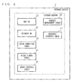
- FIG. 2 is a schematic diagram showing typical data stored in the storage medium of the storage device 2.
- a map database hereinafter, referred to as a map DB
- an element database hereinafter, referred to as an element DB
- a guide direction table 23 an guide timing table 24
- a guide contents table 25 a request management table 26 and a response contents table 27 are stored in the storage medium.
- the map DB 21 may be a known database, and includes at least nodes and links which represent connection relations between roads existing within a predetermined range.
- the node typically represents by coordinate values a feature point on a road such as an intersection, an bending point or a dead end.
- the link represents a road segment between two feature points adjoining each other.
- the element DB 22 includes essential elements for generating guide information.
- FIG. 3 is a schematic diagram showing an exemplary data structure of the element DB 22.
- a guide DB 11 illustratively includes a substantial number of phrases.
- the phrases are examples of the aforementioned elements, and are segments of voice presenting the guide information.
- FIG. 3 is a schematic diagram showing an exemplary data structure of the element DB 22.
- a guide DB 11 illustratively includes a substantial number of phrases.
- the phrases are examples of the aforementioned elements, and are segments of voice presenting the guide information.
- phrases 3 shows examples of the phrases such as adverbs (e.g., “oyoso (approximately)” and “mamonaku (soon)”), phrases showing travel directions (e.g., “migi houkou (right) “ and “hidari naname zenpou (diagonally forward left) "), phrases showing values (e.g., "10000” and "900") and phrases showing proper nouns (e.g., "A kousa ten wo (A intersection)” and “B chou wo (town B)”).
- adverbs e.g., "oyoso (approximately)” and “mamonaku (soon)
- travel directions e.g., “migi houkou (right) " and “hidari naname zenpou (diagonally forward left) "
- values e.g., "10000” and "900”
- phrases showing proper nouns e.g., "
- FIG. 4A is a schematic diagram showing an area surrounding a node N1 which is an object intersection.
- FIG. 4A shows the node N1 and a link L1.
- the node N1 represents an object intersection into which a vehicle is going to proceed.
- the link L1 represents a road segment on which the vehicle is currently traveling, and the link L1 is connected to the node N1.
- angular ranges ⁇ 1 to ⁇ 24 which are obtained by dividing, while using a proceeding direction of the vehicle as a reference angle, a 360-degree area around the node N1 into 24 angular ranges, the area having the node N1 as a center.
- a proceeding vector of the vehicle is a reference angle (e.g., 0°) and that the angle increases in an anticlockwise direction.
- the angular range ⁇ 1 is 352.5° ⁇ a ⁇ +7.5° .
- An angular range ⁇ i is obtained by rotating forward an angular range ⁇ (i-1) by 30° centering around the node N1.
- i is any natural number between 2 to 24.
- the area surrounding the node N1 may be discretionarily divided into any number of angular ranges other than the 24 angular ranges.
- eight directions i.e., straightforward, diagonally forward left, left, diagonally backward left, U-turn direction, diagonally backward right, right and diagonally forward right are set as the guide directions for a vehicle by using the node N1 and the link L1 as reference points.
- the angular ranges ⁇ 12 to ⁇ 14 are allocated to the straightforward direction. If a direction of a road segment on which a vehicle travels immediately after passing through an object intersection is within the angular ranges ⁇ 12 and ⁇ 14, that means the vehicle passes straight through the object intersection. In such a case, the route guide device determines that guide information is not necessary, and does not provide any guide information for a user.
- the angular ranges ⁇ 15 to ⁇ 17 are allocated to the diagonally forward left direction; the angular ranges ⁇ 18 to ⁇ 20 are allocated to the left direction; and the angular ranges ⁇ 21 to ⁇ 23 are allocated to the diagonally backward left direction.
- four sets of three angular ranges, which are respectively symmetric, with respect to the node N1 to the four sets of three angular ranges allocated to the straightforward direction, the diagonally forward left direction, the left direction and the diagonally backward left direction, are allocated to the U-turn direction, the diagonally backward right direction, the right direction and the diagonally forward right direction, respectively.
- FIG. 4A further shows a link L2 representing a road segment on which the vehicle travels immediately after passing through the node N1. If the link 2 is included in the angular range ⁇ 18, the route guide device generates guide information for guiding the vehicle to the left direction.
- FIG. 4B is a schematic diagram showing an exemplary data structure and exemplary contents of the guide direction table 23 in the case where the route guide device is in the initial state.
- the angular ranges respectively allocated to the guide directions are written.
- the angular ranges ⁇ 12 to ⁇ 14 are allocated to chokushin houkou (straightforward); the angular ranges ⁇ 15 to ⁇ 17 are allocated to hidari naname zenpou (diagonally forward left); the angular ranges ⁇ 18 to ⁇ 20 are allocated to hidati houkou (left); the angular ranges ⁇ 21 to ⁇ 23 are allocated to hidari naname kouhou (diagonally backward left) ; the angular ranges ⁇ 24, ⁇ 1 and ⁇ 2 are allocated to U taan houkou (U-turn direction); and the angular ranges ⁇ 3 to ⁇ 5, the angular ranges ⁇ 6 to ⁇ 8 and the angular ranges ⁇ 9 to ⁇ 11 are allocated to migi naname kouhou (diagonally backward right), migi houkou (right) and migi naname
- FIG. 5 is a schematic diagram showing an exemplary data structure and exemplary contents of the guide timing table 24 in the initial state.
- exemplary timings to provide guidance i.e., guide timings are written, e.g., "at the start of route guiding", “at a point which is 700m before an object intersection”, “at a point which is 300m before an object intersection”, “at a point which is 100m before an object intersection”, “at a point which is 2km before a destination point”, “at a point which is 1km before a destination point” and “at a point which is 100m before a destination point”.
- the guide timing table 24 may be rewritten by the arithmetic processing unit 4 in accordance with a user's tendency.
- FIG. 6 is a schematic diagram showing an exemplary data structure and exemplary contents of the guide contents table 25 in the initial state.
- the guide timings are defined as above, seven sets of contents of guide information are defined in the guide contents table 25.
- the guide contents table 25 may also be rewritten by the arithmetic processing unit 4.
- guide information whose content is “onsei annai wo kaishi shimasu (Voice guiding starts now)" is provided at the start of route guiding.
- element numbers 1 and 2 are written in the guide contents table 25.
- the route guide device provides the guide information "onsei annai wo kaishi shimasu (Voice guiding starts now)" by sequentially outputting phrases that are specified by the element numbers 1 and 2.
- the element numbers 4, 10, *j and 18 are written for the guide timing "at a point which is 700m before an object intersection".
- *j indicates an element number representing a guide direction which the arithmetic processing unit 4 has determined by referring to the guide direction table 23 of FIG. 4B. Since the aforementioned guide directions are written in the guide direction table 23, *j is any number selected from element numbers 101 to 107. Accordingly, at a point which is 700m before an object intersection, guide information whose content is "oyoso 700m de XX desu (In approximately 700m, turn XX)" is provided (XX is a direction specified by *j). Element numbers selected in the same manner are written also for each of the guide timings "at a point which is 300m before an object intersection” and "at a point which is 100m before an object intersection”.
- element numbers 4, 8, 14 and 18 are written for the guide timing "at a point which is 2km before a destination point". Based on this, at a point which is 2km before a destination point, guide information whose content is “oyoso 2km de mokutekichi desu (The destination point is approximately 2km ahead)" is provided. Element numbers selected in the same manner are written also for each of the guide timings "at a point which is 1km before a destination point" and "at a point which is 100m before a destination point”.
- the request management table 26 is a table for recording the number of times each guide request is inputted from the input device 1.
- FIG. 7 is a schematic diagram showing an exemplary data structure and exemplary contents of the request management table 26.
- a guide request may be a request for reoutputting immediately-previous guide information which has been outputted.
- Another guide request may be a request for outputting guide information which is different from the immediately-previous guide information having been outputted.
- Further another guide request may be a request made by a user when no guide information has been outputted.
- Contents of the guide requests in the present embodiment are, for example, "mejirushi wa? (What is the landmark?)”, “kousa ten no namae wa? (What is the name of the intersection?)”, “shoyou jikan wa? (How long does it take?)”, “kyori wa? (How far is it?)” and “koko? (Is it here?)”.
- N1 is a variable representing the number of times a user has asked “mejirushi wa? (What is the landmark?) ".
- N2 is recorded for the guide request "kousa ten no namae wa? (What is the name of the intersection?)”.
- N2 is a variable representing the number of times a user has asked "kousa ten no namae wa? (What is the name of the intersection?)”.
- N3 and N4 are also variables. To be specific, N3 is the number of times a user has asked “shoyou jikan wa? (How long does it take?)" at the start of route guiding, and N4 is the number of times the user has asked the same question after the start of route guiding.
- N5 and N6 are variables. To be specific, N5 is the number of times a user has asked “kyori wa? (How far is it?)" at the start of route guiding, and N6 is the number of times the user has asked the same question after the start of route guiding. For the guide request "koko?
- N7 is a variable representing the number of times a user has asked "koko? (Is it here?)” at a point which is just before a non-obj ect intersection
- N8 is a variable representing the number of times the user has asked the same question at a point which is just before an object intersection.
- FIG. 8 is a schematic diagram showing an exemplary data structure and exemplary contents of the response contents table 27 in the initial state.
- element numbers *k, 13 and 18 are written in the table for the guide request "mejirushi wa? (What is the landmark?)".
- *k indicates an element number representing a noun (i.e., landmark) selected by the arithmetic processing unit 4.
- element numbers *m and 18 are written in the table for the guide request "kousa ten no namae wa? (What is the name of the intersection?)”.
- *m indicates an element number representing the name of an intersection selected by the arithmetic processing unit 4 (e.g., element number 1001). Accordingly, when a user asks "kousa ten no namae wa? (What is the name of the intersection?)", the route guide device replies "XX kousa ten desu (It is XX intersection)”.
- the route guide device replies, for example, "shoyou jikan wa oyoso XX hun desu (Travel time is approximately XX minutes) ", and if the user asks the same question after the start of route guiding, the route guide device replies, for example, "nokori oyoso XX hun desu (Remaining travel time is approximately XX minutes)”.
- Element numbers selected in the same manner are written also for "kyori wa? (How far is it?)”.
- an element number *p is written for "koko? (Is it here?)".
- *p represents either an element number 25 or an element number 26.
- the locator 3 typically includes an antenna and a receiver for receiving information from a positioning system such as GPS (Global Positioning System), and also includes an autonomous navigation sensor that typically includes a speed sensor and a gyro sensor.
- GPS Global Positioning System
- the antenna and the receiver of the GPS calculate an absolute position of a vehicle on the ground by using information which is transmitted from an artificial satellite and stored in the positioning system.
- the velocity sensor and the gyro sensor mounted on the vehicle detect a traveling speed and a direction change of the vehicle.
- the locator 3 may include either a combination of the antenna and receiver or the autonomous navigation sensor.
- the arithmetic processing unit 4 processes various data by using data stored in the storage device 1, an output signal from the input device 2 and an output signal from the locator 3.
- FIG. 9 is a schematic diagram showing an exemplary hardware structure of the arithmetic processing unit 4.
- the arithmetic processing unit 4 includes a program memory 41, a processor 42 and a working area 43.
- the program memory 41 is typically an ROM (Read Only Memory), and stores a computer program 411 (hereinafter, referred to as a program). Operation details of the arithmetic processing unit 4 are written in the program 411 as a main portion of the program 411.
- the processor 42 executes the above program 411.
- the working area 43 is typically an RAM (Random Access Memory), and is used to enable the processor 42 to execute the program 411.
- the output section 5 includes a display device and/or a speaker.
- the display device displays various information generated by the arithmetic processing unit 4, and the speaker outputs the various information, which is generated by the arithmetic processing unit 4, in the form of voice.
- the processor 42 performs initialization after the route guide device starts up, and then performs various processes in accordance with the program 411 by using the working area 43.
- the processor 42 determines whether a current position of a vehicle should be calculated (FIG. 10A; step S1). The current position is calculated at predetermined regular time intervals, for example, every second.
- the processor 42 determines "YES" at step S1
- the processor 42 calculates the current position by using the output signal from the locator 3 (step S2).
- the processor 42 uses the map DB 21 to generate a map image of an area surrounding the current position.
- the generated map image is transferred to the display device of the output device 5, and the display device outputs the map image received (step S3).
- step S3 the processor 42 determines whether a destination point has been received from the input device 1 (step S4).
- the processor 42 searches for, in accordance with a known algorithm, a route from a departure point to the destination point by using the map DB 21 (step S5).
- a route which is found contains at least a node string. Note that, a point sent from the input device 1 or the current position of the vehicle may be used as the departure point.
- the processor 42 selects, from the node string contained in the route having been found, an intersection regarding which guide information should be provided (object intersection) (step S6).
- object intersection an intersection regarding which guide information should be provided.
- step S7 determines whether a current moment is a guide timing. To be specific, the processor 42 determines whether the current moment is one of the timings defined in the guide timing table 24 or whether the current position obtained at step S2 is one of the positions defined in the guide timing table 24.
- the processor 42 determines "Yes" at step S7, the processor 42 then obtains, from the guide contents table 25, element numbers currently required.
- the processor 42 further obtains, from the element DB 22, a combination of phrases whose numbers are the same as the element numbers having been obtained. Thereafter, the processor 42 joins the obtained phrases together to generate guide information whose guide content is presented in the form of voice.
- guide information whose content is “onsei annai wo kaishi shimasu (Voice guiding starts now) " is generated at the start of route guiding.
- the processor 42 calculates which one of the angular ranges ⁇ shown in FIG. 4A includes an escape link from an object intersection, and then determines a guide direction. According to the guide direction determined, the processor 42 obtains, from the element DB 22, a phrase which is appropriate as *j shown in FIG. 6.
- a position of a vehicle is, for example, at 700m before the object intersection, and a guide direction is determined as migi houkou (right)
- guide information whose content is “oyoso 700m de migi houkou desu (In approximately 700m, turn right) " is provided.
- guide information whose content is "oyoso 2km de mokutekichi desu (The destination point is approximately 2km ahead)" is generated.
- the guide information generated as described above is transferred from the arithmetic processing unit 4 to the output device 5, and the speaker of the output device 5 outputs voice in accordance with the guide information received (step S8).
- a user determines whether a guide request has been received from the input device 1 (FIG. 10B; step S9).
- exemplary requests shown in FIG. 7 are defined as the guide requests.
- a user can input, by voice, a guide request to the route guide device.
- the voice of the user is inputted into the microphone of the input device 1, the microphone generates a voice signal indicating the inputted voice of the user, and gives the signal to the arithmetic processing unit 4.
- the processor 42 determines "YES" at step S9 by using a known voice recognition algorithm.
- the processor 42 determines as above, the processor 42 then updates the request management table 26 (step S10). To be specific, in the request management table 26,the processor 42 increments, by 1, the number of times a current guide request is inputted. When "mejirushi wa? (What is the landmark?)" is asked, N1 of the request management table 26 is incremented by 1. Similarly, when the other guide request is made, one of the numbers of times of input N2 to N8, which corresponds to the guide request, is incremented by 1.
- the processor 42 edits each type of table while referring to the request management table 26, which has been updated (step S11).
- FIG. 11 is a flow chart showing a process of step S11 in detail.
- the processor 42 determines whether the number of times of input "N1" has become equal or above a standard value N (step S21). When the processor 42 determines "Yes", the processor 42 then determines that the user tends to need a landmark as guide information regarding an object intersection, and then adds, to the guide contents table 26, an element number that specifies a necessary phrase for outputting a landmark (step S22). To be specific, for example, as shown within a bold-line frame in FIG.
- element numbers *q, 13 and 18 are added for each of the guide timings "at a point which is 700m before an object intersection", “at a point which is 300m before an object intersection” and “at a point which is 100m before an object intersection”.
- *q indicates an element number allocated to a phrase indicating a landmark.
- phrases such as "konbiniensu sutoa ga (a convenience store)", “gasorin sutando ga (a gas station)", “fammati resutoran ga (a family restaurant) " and so on, which indicate things which can be used as landmarks, are written. Therefore, *q is one or more numbers selected from the element numbers 201 to 210.
- guide information whose content is "mejirushi ha konbiniensu sutoa desu (A landmark is a convenience store)” other than “oyoso 700m de XX desu (In approximately 700m, turn XX)" is provided.
- the element numbers selected in the same manner are added also for each of the guide timings "at a point which is 300m before an object intersection” and "at a point which is 100m before an object intersection”.
- step S22 the processor 42 determines whether the number of times of input "N2" has become equal or above the standard value N (step S23).
- step S23 the processor 42 determines that the user tends to need the name of an object intersection, and adds, to the guide contents table 26, an element number that specifies a necessary phrase for outputting the name of an intersection (step S24).
- an element number *r is added just before *j for each of the guide timings "at a point which is 700m before an object intersection", "at a point which is 300m before an object intersection” and "at a point which is 100m before an object intersection”.
- *r indicates an element number allocated to a phrase indicating the name of an intersection.
- a phrase "A kousa ten wo (A intersection)", which indicates an intersection is shown as an example. Therefore, *r is an element number 1001.
- guide information whose content is "oyoso 700m de A kousa ten wo XX houkou desu (In approximately 700m, turn XX at A intersection)" is provided.
- the element number selected in the same manner is added also for each of the guide timings "at a point which is 300m before an object intersection” and "at a point which is 100m before an object intersection”.
- step S24 the processor 42 determines whether the number of times of input "N3" or the number of times of input "N5" has become equal or above the standard value N (step S25) .
- the processor 42 determines "YES” at step S25, the processor 42 then determines that the user tends to need, at the start of route guiding, a travel distance and a travel time, and then adds, in the guide contents table 26, to guide information which is defined to be outputted at the start of route guiding, element numbers that specify necessary phrases for outputting a travel distance and a travel time (step S26).
- step S26 To be specific, as shown within a bold-line frame in FIG.
- step S26 the processor 42 determines whether the number of times of input "N7" has become equal or above the standard value N (step S27).
- step S27 the processor 42 determines "YES” at step S27, as will be described in further detail below, the processor 42 then rewrites the guide direction table 23 (step S28).
- the number of times of input "N7” represents the number of times a user has asked "koko? (Is it here?)” just before a non-obj ect intersection.
- N7 is such a high value indicates that the user thinks a vehicle should not pass straight through the intersection although the route guide device does not determine the intersection as a guide object intersection since the route guide device considers that the vehicle should pass straight through the intersection.
- the processor 42 expands, by one range to the straightforward direction, the angular ranges allocated to the diagonally forward left direction and the diagonally forward right direction, respectively.
- step S28 the processor 42 determines whether the number of times of input "N8" has become equal or above the standard value N (step S29).
- the processor 42 determines "YES” at step S29, the processor 42 then determines that the user is unconfident about identifying which intersection is an object intersection, and edits the guide timing table 24 and the guide contents table 25 (step S210).
- the processor 24 adds, to the guide timing table 24, a new distance from an object intersection (e.g., 40m as shown in FIG. 16) as a new guide timing in addition to the guide timings which have already been defined. As shown within a bold-line frame in FIG.
- the processor 24 further adds, to the guide contents table 25, the newly-added guide timing along with element numbers *j and 18.
- a guide information content is thus added for the newly-added guide timing. This allows guide information whose content is "hidari houkou desu (turn left)" to be provided at a point which is 40m before the object intersection.
- step S210 or when the processor 42 determines "NO" at step S29, the processor 42 then completes the editing process shown in FIG. 11, and performs step S12 of FIG. 10B.
- the processor 42 obtains, from the response contents table 27, element numbers currently required. Further, in the same manner as the described process at step S8, the processor 42 joins together phrases obtained from the element DB 22 to generate guide information whose response content is presented in the form of voice.
- the processor 42 determines whether or not to terminate the processing shown in FIGS. 10A and 10B (step S13). When the processor 42 determines "NO”, the processor 42 then performs step S1 shown in FIG. 10A. When the processor 42 determines "YES”, the processor 42 then terminates the processing.
- the interactive route guide device has the input device 1 allowing a user to input a guide request.
- the arithmetic processing unit 4 manages, by using the request management table 26, at least a content of a guide request from the user and the number of times the guide request is inputted. Further, the arithmetic processing unit 4 refers to the request management table 26, and if the number of times the guide request with the same content has been inputted becomes equal or above the standard value N, the arithmetic processing unit 4 edits the tables 23, 24, 25 and 27, which are in the storage device 2. The arithmetic processing unit 4 generates guide information by using the tables 23, 24, 25 and 27, which are thus edited. This allows the interactive route guide device to provide the user with an appropriate amount of guide information having an appropriate content with an appropriate timing.
- the present embodiment has been described assuming that the input device 1 is a microphone, the present invention is not limited thereto.
- a user may input a guide request by operating a manual input device such as a remote controller.
- the storage device 2 includes a storage medium that is rewritable and nonvolatile, and it is also described as a matter of convenience that the map DB 21 and the element DB 22 are also stored in the storage device 2.
- the map DB 21 and the element DB 22 do not necessarily have to be stored in the storage device 2, and may be stored in a different read-only storage device.
- the processor 42 selects all object intersections from a route which has been found, but not limited thereto, as shown in FIG. 18, from a route SR having been found (denoted by a bold line), the processor 42 may select, as an object intersection, an intersection included within a predetermined range R1 that is in the direction of a destination point DP, by using a current position CP as a reference point. However, in this case, the processor 42 is required to select, every time an object intersection ceases being present in the predetermined range R1, an object intersection from intersections included within a next range R1.
- the processor 42 adds data to the tables.
- the processor 42 may also delete, from the tables, data of a guide request that is not frequently inputted.
- N only one standard value N is used, but not limited thereto, different standard values may be prepared for N1, N2, N3, N5, N7 and N8, respectively. It is desired that each of these standard values, which corresponds to one of the guide request contents or one of the combinations of a guide request content and an input timing thereof, is separately set.
- the processor 42 determines whether N3 or N5 is equal or above the standard value N, but not limited thereto, the processor 42 may add, to the guide contents table, as a guide content, a travel distance if N3 is equal or above the standard value N, and add a travel time if N5 is equal or above the standard value N.
- the program 411 is stored in the program memory 41, but not limited thereto, the program 411 may be stored in a storage medium typified by a CD-ROM to be distributed, or may be distributed via a network. While the present invention has been described in detail, the foregoing description is illustrative and not restrictive in all aspects. It is understood that numerous other modifications and variations are possible without departing from the scope of the present invention.
- the interactive route guide device is useful for a system such as an in-vehicle navigation system that is required to have a particular technical effect, i.e., providing a user with an appropriate amount of guide information with an appropriate timing in accordance with a tendency of the user.
Abstract
A technical challenge is to provide an interactive route guide device which is capable of providing an appropriate amount of information with an appropriate timing in accordance with a user's desire. In order to overcome such a technical challenge, in the interactive route guide device, a storage device (2) stores at least one table which defines a type of guide information to be provided for a route from a departure point to a destination point. An arithmetic processing unit (4) generates the guide information according to the table in the storage device (2), and an output device (5) outputs the generated guide information. The user uses an input device (1) to input a guide request. The arithmetic processing unit (4) manages at least a content of the inputted guide request and the number of times the guide request is inputted, and edits the table stored in the storage device (2) in accordance with the content of the inputted guide request and the number of times the guide request is inputted.
Description
- The present invention relates to an interactive route guide device, and particularly to a route guide device that interactively provides guide information for a user.
- In recent years, the number of vehicles equipped with a navigation system has been increasing. A general navigation system searches for a route for a vehicle from a departure point to a destination point by using digital map data stored in a storage medium such as a CD (Compact Disc), DVD (Digital Versatile Disc) or a hard disc. Then, the navigation system provides guides with respect to a route which is found. While such guides are provided, in accordance with a predetermined fixed rule (hereinafter, referred to as a guide rule), the general navigation system, for example, determines a content of guide information to be provided for guiding the vehicle and/or a timing of providing the guide information, and displays various graphic information on a display screen, and also outputs voice information from a speaker.
- One of the navigation systems providing guides as described above is a route guide device described below which is capable of interactively providing guide information (hereinafter, referred to as a conventional route guide device). The conventional route guide device not only unilaterally provides guide information for a user in accordance with the aforementioned fixed guide rule, but also outputs guide information in response to a request from the user. To be specific, the user requests, by manual input and/or voice input, the conventional route guide device to output guide information. In response to the request, the conventional route guide device selects guide information comprising a remaining travel distance to a destination point, a landmark object and a travel direction, and then provides the selected guide information for the user (Refer to, e.g.,
Japanese Laid-Open Patent Publication No. 8-254437 - However, it can be considered that there is a tendency for guide information needed by each user to vary to some extent depending on each user's personality. For this reason, there is a problem that a user sometimes cannot obtain, from the conventional route guide device, an appropriate amount of guide information having an appropriate content for the user.
- There is also another problem that a user gets annoyed since the conventional route guide device requires the user to operate the device before providing guide information. To be specific, as described above, there is a tendency for guide information needed by each user to vary depending on each user' s personality, and the conventional route guide device requires a user to repeatedly operate the device in a same manner in similar situations. For example, if a user tends to request guide information at 100m before passing an intersection, the user is required to operate the conventional route guide device at 100m before proceeding into a first intersection, and the user is again required to operate the device at 100m before proceeding into a next intersection.
- Therefore, an object of the present invention is to provide an interactive route guide device that is capable of providing, in accordance with a tendency of a user, an appropriate amount of guide information having an appropriate content with an appropriate timing.
- In order to achieve the above object, a first aspect of the present invention is directed to the interactive route guide device. The interactive route guide device comprises: a storage unit operable to store at least one table which defines a type of guide information to be provided for a route from a departure point to a destination point; a guide information generating unit operable to generate guide information in accordance with the table in the storage unit; an output unit operable to output the guide information generated in the guide information generating unit; an input unit which a user operates in order to request guide information; a request management unit operable to manage a content of a request inputted into the input unit and a number of times the request is inputted; and an editing unit operable to edit the table, which is stored in the storage unit, in accordance with the content and the number of times, which are managed by the request management unit.
- The storage unit stores the table in which a timing of providing the guide information is written, and the editing unit changes the timing, which is written in the table, in accordance with the content and the number of times, which are managed by the request management unit.
- The storage unit stores the table in which guide directions from an intersection, for which the guide information should be provided, are written, and the editing unit changes the guide directions, which are written in the table, in accordance with the content and the number of times, which are managed by the request management unit.
- The storage unit stores the table, in which a content of the guide information is defined, and the editing unit changes the content of the guide information, which is defined in the table, in accordance with the content and the number of times, which are managed by the request management unit.
- For example, the editing unit changes the content and an amount of the guide information for each time. The editing unit also changes a frequency of generating the guide information.
- A second aspect of the present invention is directed to an interactive route guide method. The interactive route guide method comprises: a guide information generating step of generating guide information in accordance with at least one table which defines a type of guide information to be provided for a route from a departure point to a destination point; an output step of outputting the guide information generated at the guide information generating step; a request management step of retaining a content of a request inputted by a user and a number of times the request is inputted; and an editing step of editing the table in accordance with the content and the number of times, which are retained at the request management step.
- A third aspect of the present invention is directed to a computer program for realizing interactive route guide. The computer program comprises: a guide information generating step of generating guide information in accordance with at least one table which defines a type of guide information to be provided for a route from a departure point to a destination point; an output step of outputting the guide information generated at the guide information generating step; a request management step of retaining a content of a request inputted by a user and a number of times the request is inputted; and an editing step of editing the table in accordance with the content and the number of times, which are retained at the request management step.
The computer program is recorded in a recording medium. - In the above aspects, the table is edited based on a content of a request from a user and the number of times the user inputs the request. In other words, the table is edited in accordance with a tendency of an individual user. According to the above aspects, guide information is generated based on such a table, and this makes it possible to provide guide information whose amount and content correspond to a user's tendency.
- The above and other objects, features, aspects and advantages of the present invention will become more apparent when the following detailed description of the present invention is understood with reference to the accompanying drawings.
- [FIG. 1] FIG. 1 is a block diagram showing a structure of an interactive route guide device according to an embodiment of the present invention.
- [FIG. 2] FIG. 2 is a schematic diagram showing typical data recorded in a storage medium of a
storage device 2 shown in FIG. 1. - [FIG. 3] FIG. 3 is a schematic diagram showing an exemplary data structure of an
element DB 22 shown in FIG. 2. - [FIG. 4A] FIG. 4A is a first schematic diagram showing an area surrounding a node N1 which is an object intersection.
- [FIG. 4B] FIG. 4B is a schematic diagram showing an exemplary data structure and exemplary contents of a guide direction table 23 (in an initial state) shown in FIG. 2.
- [FIG. 5] FIG. 5 is a schematic diagram showing an exemplary data structure and exemplary contents of a guide timing table 24 (in an initial state) shown in FIG. 2.
- [FIG. 6] FIG. 6 is a schematic diagram showing an exemplary data structure and exemplary contents of a guide contents table 25 (in an initial state) shown in FIG. 2.
- [FIG. 7] FIG. 7 is a schematic diagram showing an exemplary data structure and exemplary contents of a request management table 26 shown in FIG. 2.
- [FIG. 8] FIG. 8 is a schematic diagram showing an exemplary data structure and exemplary contents of a response contents table 27 (in an initial state) shown in FIG. 2.
- [FIG. 9] FIG. 9 is a schematic diagram showing an exemplary hardware structure of an
arithmetic processing unit 4 shown in FIG. 1. - [FIG. 10A] FIG. 10A is a first half of a flow chart showing processes performed by the interactive route guide device shown in FIG. 1.
- [FIG. 10B] FIG. 10B is a second half of the flow chart showing the processes performed by the interactive route guide device shown in FIG. 1.
- [FIG. 11] FIG. 11 is a flow chart showing a detailed process of step S11 shown in FIG. 10B.
- [FIG. 12] FIG. 12 is a schematic diagram of the guide contents table 26 edited at step S22 of FIG. 11.
- [FIG. 13] FIG. 13 is a schematic diagram of the guide contents table 26 edited at step S24 of FIG. 11.
- [FIG. 14] FIG. 14 is a schematic diagram of the guide contents table 26 edited at step S26 of FIG. 11.
- [FIG. 15A] FIG. 15A is a second schematic diagram showing the area surrounding the node N1 which is the object intersection.
- [FIG. 15B] FIG. 15B is a schematic diagram of the guide direction table 23 edited at step S28 of FIG. 11.
- [FIG. 16] FIG. 16 is a schematic diagram showing the guide timing table 24 edited at step S210 of FIG. 11.
- [FIG. 17] FIG. 17 is a schematic diagram showing the guide contents table 25 edited at step S210 of FIG. 11.
- [FIG. 18] FIG. 18 is a schematic diagram showing an alternative example of a process at step S6 of FIG. 10A.
-
- 1
- input device
- 2
- storage device
- 3
- locator
- 4
- arithmetic processing unit
- 5
- output device
- FIG. 1 is a block diagram showing a structure of an interactive route guide device (hereinafter in the present embodiment, referred to as a "route guide device") according to an embodiment of the present invention. FIG. 1 shows the route guide device, which is mounted on, for example, an in-vehicle navigation system and comprises an
input device 1, astorage device 2, alocator 3, anarithmetic processing unit 4 and anoutput device 5. - The
input device 1 is a device that a user operates in order to input various information into the route guide device. In the present embodiment, theinput device 1 includes a microphone. A user inputs, by voice, requests for various guides into the microphone. - Preferably, the
storage device 2 writes data on a storage medium which is rewritable and nonvolatile, and reads data from the storage medium. - FIG. 2 is a schematic diagram showing typical data stored in the storage medium of the
storage device 2. In FIG. 2, a map database (hereinafter, referred to as a map DB) 21, an element database (hereinafter, referred to as an element DB) 22, a guide direction table 23, an guide timing table 24, a guide contents table 25, a request management table 26 and a response contents table 27 are stored in the storage medium. - The
map DB 21 may be a known database, and includes at least nodes and links which represent connection relations between roads existing within a predetermined range. The node typically represents by coordinate values a feature point on a road such as an intersection, an bending point or a dead end. The link represents a road segment between two feature points adjoining each other. - The
element DB 22 includes essential elements for generating guide information. FIG. 3 is a schematic diagram showing an exemplary data structure of theelement DB 22. In FIG. 3, aguide DB 11 illustratively includes a substantial number of phrases. The phrases are examples of the aforementioned elements, and are segments of voice presenting the guide information. FIG. 3 shows examples of the phrases such as adverbs (e.g., "oyoso (approximately)" and "mamonaku (soon)"), phrases showing travel directions (e.g., "migi houkou (right) " and "hidari naname zenpou (diagonally forward left) "), phrases showing values (e.g., "10000" and "900") and phrases showing proper nouns (e.g., "A kousa ten wo (A intersection)" and "B chou wo (town B)"). An element number that does not overlap any other element number is allocated to each phrase. - In the guide direction table 23, a travel direction of a vehicle from an intersection that is an object of the guide information (i.e., guide direction) is defined (hereinafter, such an intersection is referred to as an "object intersection"). FIG. 4A is a schematic diagram showing an area surrounding a node N1 which is an object intersection. FIG. 4A shows the node N1 and a link L1. The node N1 represents an object intersection into which a vehicle is going to proceed. The link L1 represents a road segment on which the vehicle is currently traveling, and the link L1 is connected to the node N1. FIG. 4A further shows angular ranges α1 to α24 which are obtained by dividing, while using a proceeding direction of the vehicle as a reference angle, a 360-degree area around the node N1 into 24 angular ranges, the area having the node N1 as a center. Here, it is assumed that a proceeding vector of the vehicle is a reference angle (e.g., 0°) and that the angle increases in an anticlockwise direction. Under this assumption, the angular range α1 is 352.5° <a≦+7.5° . An angular range αi is obtained by rotating forward an angular range α (i-1) by 30° centering around the node N1. Here, i is any natural number between 2 to 24. Note that, according to the design specification of the route guide device, the area surrounding the node N1 may be discretionarily divided into any number of angular ranges other than the 24 angular ranges.
- Here, eight directions, i.e., straightforward, diagonally forward left, left, diagonally backward left, U-turn direction, diagonally backward right, right and diagonally forward right are set as the guide directions for a vehicle by using the node N1 and the link L1 as reference points. In an initial state, the angular ranges α12 to α14 are allocated to the straightforward direction. If a direction of a road segment on which a vehicle travels immediately after passing through an object intersection is within the angular ranges α12 and α14, that means the vehicle passes straight through the object intersection. In such a case, the route guide device determines that guide information is not necessary, and does not provide any guide information for a user. Also, in the initial state, the angular ranges α15 to α17 are allocated to the diagonally forward left direction; the angular ranges α18 to α20 are allocated to the left direction; and the angular ranges α21 to α23 are allocated to the diagonally backward left direction. Further, four sets of three angular ranges, which are respectively symmetric, with respect to the node N1, to the four sets of three angular ranges allocated to the straightforward direction, the diagonally forward left direction, the left direction and the diagonally backward left direction, are allocated to the U-turn direction, the diagonally backward right direction, the right direction and the diagonally forward right direction, respectively.
- FIG. 4A further shows a link L2 representing a road segment on which the vehicle travels immediately after passing through the node N1. If the
link 2 is included in the angular range α18, the route guide device generates guide information for guiding the vehicle to the left direction. - FIG. 4B is a schematic diagram showing an exemplary data structure and exemplary contents of the guide direction table 23 in the case where the route guide device is in the initial state. In the guide direction table 23 of FIG. 4B, the angular ranges respectively allocated to the guide directions are written. To be specific, when the route guide device is in the initial state, the angular ranges α12 to α14 are allocated to chokushin houkou (straightforward); the angular ranges α15 to α17 are allocated to hidari naname zenpou (diagonally forward left); the angular ranges α18 to α20 are allocated to hidati houkou (left); the angular ranges α21 to α23 are allocated to hidari naname kouhou (diagonally backward left) ; the angular ranges α24, α1 and α2 are allocated to U taan houkou (U-turn direction); and the angular ranges α3 to α5, the angular ranges α6 to α8 and the angular ranges α9 to α11 are allocated to migi naname kouhou (diagonally backward right), migi houkou (right) and migi naname zenpou (diagonally forward right), respectively. Note that, the angular ranges α respectively allocated to the guide directions may be otherwise rewritten by the
arithmetic processing unit 4 in accordance with a user's tendency. - Refer to FIG. 2 again. In the guide timing table 24, when or at which point the guide information is to be provided for the vehicle is defined. FIG. 5 is a schematic diagram showing an exemplary data structure and exemplary contents of the guide timing table 24 in the initial state. In the guide timing table 24 of FIG. 5, exemplary timings to provide guidance, i.e., guide timings are written, e.g., "at the start of route guiding", "at a point which is 700m before an object intersection", "at a point which is 300m before an object intersection", "at a point which is 100m before an object intersection", "at a point which is 2km before a destination point", "at a point which is 1km before a destination point" and "at a point which is 100m before a destination point". As described later, the guide timing table 24 may be rewritten by the
arithmetic processing unit 4 in accordance with a user's tendency. - Refer to FIG. 2 again. In the guide contents table 25, a content of each guide information, which is provided at a corresponding one of the aforementioned guide timings, is defined. FIG. 6 is a schematic diagram showing an exemplary data structure and exemplary contents of the guide contents table 25 in the initial state. When the guide timings are defined as above, seven sets of contents of guide information are defined in the guide contents table 25. As described later, the guide contents table 25 may also be rewritten by the
arithmetic processing unit 4. - To be specific, guide information whose content is "onsei annai wo kaishi shimasu (Voice guiding starts now)" is provided at the start of route guiding. In order to provide such guide information,
element numbers element numbers - The
element numbers arithmetic processing unit 4 has determined by referring to the guide direction table 23 of FIG. 4B. Since the aforementioned guide directions are written in the guide direction table 23, *j is any number selected fromelement numbers 101 to 107. Accordingly, at a point which is 700m before an object intersection, guide information whose content is "oyoso 700m de XX desu (In approximately 700m, turn XX)" is provided (XX is a direction specified by *j). Element numbers selected in the same manner are written also for each of the guide timings "at a point which is 300m before an object intersection" and "at a point which is 100m before an object intersection". - In addition,
element numbers - Refer to FIG. 2 again. The request management table 26 is a table for recording the number of times each guide request is inputted from the
input device 1. FIG. 7 is a schematic diagram showing an exemplary data structure and exemplary contents of the request management table 26. In the request management table 26 of FIG. 7, at least a content of each guide request and the number of times each guide request is inputted are recorded. An input timing may also be recorded regarding some guide requests. A guide request may be a request for reoutputting immediately-previous guide information which has been outputted. Another guide request may be a request for outputting guide information which is different from the immediately-previous guide information having been outputted. Further another guide request may be a request made by a user when no guide information has been outputted. Contents of the guide requests in the present embodiment are, for example, "mejirushi wa? (What is the landmark?)", "kousa ten no namae wa? (What is the name of the intersection?)", "shoyou jikan wa? (How long does it take?)", "kyori wa? (How far is it?)" and "koko? (Is it here?)". - In the request management table 26, the number of times of input "N1" is recorded for the guide request "mej irushi wa? (What is the landmark?)". Here, N1 is a variable representing the number of times a user has asked "mejirushi wa? (What is the landmark?) ". The number of times of input "N2" is recorded for the guide request "kousa ten no namae wa? (What is the name of the intersection?)". N2 is a variable representing the number of times a user has asked "kousa ten no namae wa? (What is the name of the intersection?)". In addition to an input timing "at the start of route guiding" and the number of times of input "N3", an input timing "after the start of route guiding" and the number of times of input "N4" are recorded for the guide request "shoyou jikan wa? (How long does it take?)". N3 and N4 are also variables. To be specific, N3 is the number of times a user has asked "shoyou jikan wa? (How long does it take?)" at the start of route guiding, and N4 is the number of times the user has asked the same question after the start of route guiding. In addition to the input timing "at the start of route guiding" and the number of times of input "N5", the input timing "after the start of route guiding" and the number of times of input "N6" are recorded for the guide request "kyori wa? (How far is it?)". N5 and N6 are variables. To be specific, N5 is the number of times a user has asked "kyori wa? (How far is it?)" at the start of route guiding, and N6 is the number of times the user has asked the same question after the start of route guiding. For the guide request "koko? (Is it here?)", a combination of an input timing "at a point which is just before a non-object intersection" and the number of times of input "N7" and a combination of an input timing "at a point which is just before an object intersection" and the number of times of input "N8" are recorded. N7 is a variable representing the number of times a user has asked "koko? (Is it here?)" at a point which is just before a non-obj ect intersection, and N8 is a variable representing the number of times the user has asked the same question at a point which is just before an object intersection.
- Refer to FIG. 2 again. In the response contents table 27, a content of each response, which is to be provided corresponding to one of the aforementioned guide requests, is defined. As will hereinafter be described in detail, the response contents table 27 may also be rewritten by the
arithmetic processing unit 4. FIG. 8 is a schematic diagram showing an exemplary data structure and exemplary contents of the response contents table 27 in the initial state. When the guide requests are as described above (Refer to FIG. 7), element numbers *k, 13 and 18 are written in the table for the guide request "mejirushi wa? (What is the landmark?)". Here, *k indicates an element number representing a noun (i.e., landmark) selected by thearithmetic processing unit 4. Assuming that nouns representing objects to be landmarks are allocated toelement numbers 201 to 210 in the element DB 22 (Refer to FIG. 3), *k is any number selected from theelement numbers 201 to 210. Accordingly, when a user asks "mejirushi wa? (What is the landmark?)", the route guide device provides guide information whose response content is "XX ga mejirushi desu (XX is a landmark)". - Also, element numbers *m and 18 are written in the table for the guide request "kousa ten no namae wa? (What is the name of the intersection?)". Here, *m indicates an element number representing the name of an intersection selected by the arithmetic processing unit 4 (e.g., element number 1001). Accordingly, when a user asks "kousa ten no namae wa? (What is the name of the intersection?)", the route guide device replies "XX kousa ten desu (It is XX intersection)".
- In addition, a combination of
element numbers element numbers arithmetic processing unit 4. Based on these combinations, if a user asks "shoyou jikan wa? (How long does it take?)" at the start of route guiding, the route guide device replies, for example, "shoyou jikan wa oyoso XX hun desu (Travel time is approximately XX minutes) ", and if the user asks the same question after the start of route guiding, the route guide device replies, for example, "nokori oyoso XX hun desu (Remaining travel time is approximately XX minutes)". Element numbers selected in the same manner are written also for "kyori wa? (How far is it?)".
Further, an element number *p is written for "koko? (Is it here?)". Here, *p represents either anelement number 25 or anelement number 26. - Refer to FIG. 1 again. The
locator 3 typically includes an antenna and a receiver for receiving information from a positioning system such as GPS (Global Positioning System), and also includes an autonomous navigation sensor that typically includes a speed sensor and a gyro sensor. The antenna and the receiver of the GPS calculate an absolute position of a vehicle on the ground by using information which is transmitted from an artificial satellite and stored in the positioning system. The velocity sensor and the gyro sensor mounted on the vehicle detect a traveling speed and a direction change of the vehicle. Thelocator 3 may include either a combination of the antenna and receiver or the autonomous navigation sensor. - The
arithmetic processing unit 4 processes various data by using data stored in thestorage device 1, an output signal from theinput device 2 and an output signal from thelocator 3. - FIG. 9 is a schematic diagram showing an exemplary hardware structure of the
arithmetic processing unit 4. In FIG. 9, thearithmetic processing unit 4 includes aprogram memory 41, aprocessor 42 and a workingarea 43. Theprogram memory 41 is typically an ROM (Read Only Memory), and stores a computer program 411 (hereinafter, referred to as a program). Operation details of thearithmetic processing unit 4 are written in theprogram 411 as a main portion of theprogram 411. Theprocessor 42 executes theabove program 411. The workingarea 43 is typically an RAM (Random Access Memory), and is used to enable theprocessor 42 to execute theprogram 411. - Refer to FIG. 1 again. The
output section 5 includes a display device and/or a speaker. The display device displays various information generated by thearithmetic processing unit 4, and the speaker outputs the various information, which is generated by thearithmetic processing unit 4, in the form of voice. - Next, an operation of the route guide device will be described with reference to flow charts of FIGS. 10A and 10B. In FIG. 10, the
processor 42 performs initialization after the route guide device starts up, and then performs various processes in accordance with theprogram 411 by using the workingarea 43. After step S1, theprocessor 42 determines whether a current position of a vehicle should be calculated (FIG. 10A; step S1). The current position is calculated at predetermined regular time intervals, for example, every second. When theprocessor 42 determines "YES" at step S1, theprocessor 42 then calculates the current position by using the output signal from the locator 3 (step S2). Thereafter, theprocessor 42 uses themap DB 21 to generate a map image of an area surrounding the current position. The generated map image is transferred to the display device of theoutput device 5, and the display device outputs the map image received (step S3). - After step S3, or when the
processor 42 determines "NO" at step S1, theprocessor 42 then determines whether a destination point has been received from the input device 1 (step S4). When theprocessor 42 determines "Yes" at step S4, theprocessor 42 then searches for, in accordance with a known algorithm, a route from a departure point to the destination point by using the map DB 21 (step S5). Here, a route which is found contains at least a node string. Note that, a point sent from theinput device 1 or the current position of the vehicle may be used as the departure point. - Next, the
processor 42 selects, from the node string contained in the route having been found, an intersection regarding which guide information should be provided (object intersection) (step S6). As described above, it is assumed in the present embodiment that guide information is not provided regarding an intersection which a vehicle passes straight through. Therefore, at step S6, an intersection that is not in the straightforward direction, which is one of the above-described guide directions, is determined as an object intersection. - After step S6, or when the
processor 42 determines "No" at step S4, theprocessor 42 then determines whether a current moment is a guide timing (step S7). To be specific, theprocessor 42 determines whether the current moment is one of the timings defined in the guide timing table 24 or whether the current position obtained at step S2 is one of the positions defined in the guide timing table 24. - When the
processor 42 determines "Yes" at step S7, theprocessor 42 then obtains, from the guide contents table 25, element numbers currently required. Theprocessor 42 further obtains, from theelement DB 22, a combination of phrases whose numbers are the same as the element numbers having been obtained. Thereafter, theprocessor 42 joins the obtained phrases together to generate guide information whose guide content is presented in the form of voice. - In the case where the guide timings are defined as shown in FIG. 5, guide information whose content is "onsei annai wo kaishi shimasu (Voice guiding starts now) " is generated at the start of route guiding. When the current position is at, for example, 700m, 300m or 100m before an object intersection, the
processor 42 calculates which one of the angular ranges α shown in FIG. 4A includes an escape link from an object intersection, and then determines a guide direction. According to the guide direction determined, theprocessor 42 obtains, from theelement DB 22, a phrase which is appropriate as *j shown in FIG. 6. Accordingly, when a position of a vehicle is, for example, at 700m before the object intersection, and a guide direction is determined as migi houkou (right), guide information whose content is "oyoso 700m de migi houkou desu (In approximately 700m, turn right) " is provided. Also, when the current position of the vehicle is at, for example, 2km before a destination point, guide information whose content is "oyoso 2km de mokutekichi desu (The destination point is approximately 2km ahead)" is generated. - The guide information generated as described above is transferred from the
arithmetic processing unit 4 to theoutput device 5, and the speaker of theoutput device 5 outputs voice in accordance with the guide information received (step S8). - After step S8, or when the
processor 42 determines "No" at step S7, theprocessor 42 then determines whether a guide request has been received from the input device 1 (FIG. 10B; step S9). In the present embodiment, exemplary requests shown in FIG. 7 are defined as the guide requests.
In the present embodiment, in order to provide more convenience for a user, a user can input, by voice, a guide request to the route guide device. When the voice of the user is inputted into the microphone of theinput device 1, the microphone generates a voice signal indicating the inputted voice of the user, and gives the signal to thearithmetic processing unit 4. In thearithmetic processing unit 4, if the inputted voice is any of the above described guide requests, theprocessor 42 determines "YES" at step S9 by using a known voice recognition algorithm. - When the
processor 42 determines as above, theprocessor 42 then updates the request management table 26 (step S10). To be specific, in the request management table 26,theprocessor 42 increments, by 1, the number of times a current guide request is inputted. When "mejirushi wa? (What is the landmark?)" is asked, N1 of the request management table 26 is incremented by 1. Similarly, when the other guide request is made, one of the numbers of times of input N2 to N8, which corresponds to the guide request, is incremented by 1. - Then, the
processor 42 edits each type of table while referring to the request management table 26, which has been updated (step S11). - FIG. 11 is a flow chart showing a process of step S11 in detail. In FIG. 11, the
processor 42 determines whether the number of times of input "N1" has become equal or above a standard value N (step S21). When theprocessor 42 determines "Yes", theprocessor 42 then determines that the user tends to need a landmark as guide information regarding an object intersection, and then adds, to the guide contents table 26, an element number that specifies a necessary phrase for outputting a landmark (step S22). To be specific, for example, as shown within a bold-line frame in FIG. 12, element numbers *q, 13 and 18 are added for each of the guide timings "at a point which is 700m before an object intersection", "at a point which is 300m before an object intersection" and "at a point which is 100m before an object intersection". Here, *q indicates an element number allocated to a phrase indicating a landmark. In theelement DB 22 of the present embodiment, phrases such as "konbiniensu sutoa ga (a convenience store)", "gasorin sutando ga (a gas station)", "famirii resutoran ga (a family restaurant) " and so on, which indicate things which can be used as landmarks, are written. Therefore, *q is one or more numbers selected from theelement numbers 201 to 210. Accordingly, for example, at a point which is 700m before an object intersection, guide information whose content is "mejirushi ha konbiniensu sutoa desu (A landmark is a convenience store)" other than "oyoso 700m de XX desu (In approximately 700m, turn XX)" is provided. The element numbers selected in the same manner are added also for each of the guide timings "at a point which is 300m before an object intersection" and "at a point which is 100m before an object intersection". - After step S22, or when the
processor 42 determines "NO" at step S21, theprocessor 42 then determines whether the number of times of input "N2" has become equal or above the standard value N (step S23). When theprocessor 42 determines "YES" at step S23, theprocessor 42 then determines that the user tends to need the name of an object intersection, and adds, to the guide contents table 26, an element number that specifies a necessary phrase for outputting the name of an intersection (step S24). To be specific, for example, as shown within a bold-line frame in FIG. 13, an element number *r is added just before *j for each of the guide timings "at a point which is 700m before an object intersection", "at a point which is 300m before an object intersection" and "at a point which is 100m before an object intersection". Here, *r indicates an element number allocated to a phrase indicating the name of an intersection. In theelement DB 22 of the present embodiment, a phrase "A kousa ten wo (A intersection)", which indicates an intersection, is shown as an example. Therefore, *r is anelement number 1001. Accordingly, for example, at a point which is 700m before an object intersection, guide information whose content is "oyoso 700m de A kousa ten wo XX houkou desu (In approximately 700m, turn XX at A intersection)" is provided. The element number selected in the same manner is added also for each of the guide timings "at a point which is 300m before an object intersection" and "at a point which is 100m before an object intersection". - After step S24, or when the
processor 42 determines "NO" at step S23, theprocessor 42 then determines whether the number of times of input "N3" or the number of times of input "N5" has become equal or above the standard value N (step S25) . When theprocessor 42 determines "YES" at step S25, theprocessor 42 then determines that the user tends to need, at the start of route guiding, a travel distance and a travel time, and then adds, in the guide contents table 26, to guide information which is defined to be outputted at the start of route guiding, element numbers that specify necessary phrases for outputting a travel distance and a travel time (step S26). To be specific, as shown within a bold-line frame in FIG. 14,element numbers 15, *n, 19, 16, *s, 22 and 18 are added for the guide timing "at the start of route guiding". Here, *n and *r are as described above. Accordingly, for example, at the start of route guiding, guide information whose content is "onsei annai wo kaishi shimasu (Voice guiding starts now), soukou kyori wa 15km desu (The travel distance is 15 km),shoyou jikan wa 15 hun desu (The travel time is 15 minutes)" is provided. - After step S26, or when the
processor 42 determines "NO" at step S25, theprocessor 42 then determines whether the number of times of input "N7" has become equal or above the standard value N (step S27). When theprocessor 42 determines "YES" at step S27, as will be described in further detail below, theprocessor 42 then rewrites the guide direction table 23 (step S28). As described above, the number of times of input "N7" represents the number of times a user has asked "koko? (Is it here?)" just before a non-obj ect intersection. The fact that N7 is such a high value indicates that the user thinks a vehicle should not pass straight through the intersection although the route guide device does not determine the intersection as a guide object intersection since the route guide device considers that the vehicle should pass straight through the intersection. Then, as shown in FIGS. 15A and 15B, in the guide direction table 23, theprocessor 42 expands, by one range to the straightforward direction, the angular ranges allocated to the diagonally forward left direction and the diagonally forward right direction, respectively. As a result, for example, even if an escape link L2 is included in the angular range α14, guide information whose content is "oyoso 700m de A kousaten wo hidari naname zenpou desu (In approximately 700m, turn diagonally forward left at A intersection)" is outputted. - After step S28, or when the
processor 42 determines "NO" at step S27, theprocessor 42 then determines whether the number of times of input "N8" has become equal or above the standard value N (step S29). When theprocessor 42 determines "YES" at step S29, theprocessor 42 then determines that the user is unconfident about identifying which intersection is an object intersection, and edits the guide timing table 24 and the guide contents table 25 (step S210). To be specific, as shown in FIG. 16, theprocessor 24 adds, to the guide timing table 24, a new distance from an object intersection (e.g., 40m as shown in FIG. 16) as a new guide timing in addition to the guide timings which have already been defined. As shown within a bold-line frame in FIG. 17, theprocessor 24 further adds, to the guide contents table 25, the newly-added guide timing along with element numbers *j and 18. A guide information content is thus added for the newly-added guide timing. This allows guide information whose content is "hidari houkou desu (turn left)" to be provided at a point which is 40m before the object intersection. - After step S210, or when the
processor 42 determines "NO" at step S29, theprocessor 42 then completes the editing process shown in FIG. 11, and performs step S12 of FIG. 10B. - At step S12, in accordance with a content and an input timing of a guide request, the
processor 42 obtains, from the response contents table 27, element numbers currently required. Further, in the same manner as the described process at step S8, theprocessor 42 joins together phrases obtained from theelement DB 22 to generate guide information whose response content is presented in the form of voice. - Thereafter, the
processor 42 determines whether or not to terminate the processing shown in FIGS. 10A and 10B (step S13). When theprocessor 42 determines "NO", theprocessor 42 then performs step S1 shown in FIG. 10A. When theprocessor 42 determines "YES", theprocessor 42 then terminates the processing. - As described above, the interactive route guide device has the
input device 1 allowing a user to input a guide request. Thearithmetic processing unit 4 manages, by using the request management table 26, at least a content of a guide request from the user and the number of times the guide request is inputted. Further, thearithmetic processing unit 4 refers to the request management table 26, and if the number of times the guide request with the same content has been inputted becomes equal or above the standard value N, thearithmetic processing unit 4 edits the tables 23, 24, 25 and 27, which are in thestorage device 2. Thearithmetic processing unit 4 generates guide information by using the tables 23, 24, 25 and 27, which are thus edited. This allows the interactive route guide device to provide the user with an appropriate amount of guide information having an appropriate content with an appropriate timing. - Note that, although the present embodiment has been described assuming that the
input device 1 is a microphone, the present invention is not limited thereto. For example, a user may input a guide request by operating a manual input device such as a remote controller. - As described in the above embodiment, since the tables 23 to 27 are updated and edited by the
arithmetic control unit 4, thestorage device 2 includes a storage medium that is rewritable and nonvolatile, and it is also described as a matter of convenience that themap DB 21 and theelement DB 22 are also stored in thestorage device 2. However, themap DB 21 and theelement DB 22 do not necessarily have to be stored in thestorage device 2, and may be stored in a different read-only storage device. - As described in the above embodiment, at step S6, the
processor 42 selects all object intersections from a route which has been found, but not limited thereto, as shown in FIG. 18, from a route SR having been found (denoted by a bold line), theprocessor 42 may select, as an object intersection, an intersection included within a predetermined range R1 that is in the direction of a destination point DP, by using a current position CP as a reference point. However, in this case, theprocessor 42 is required to select, every time an object intersection ceases being present in the predetermined range R1, an object intersection from intersections included within a next range R1. - As described above in the embodiment, the
processor 42 adds data to the tables. However, for example, theprocessor 42 may also delete, from the tables, data of a guide request that is not frequently inputted. - In the process of FIG. 11 of the above embodiment, only one standard value N is used, but not limited thereto, different standard values may be prepared for N1, N2, N3, N5, N7 and N8, respectively. It is desired that each of these standard values, which corresponds to one of the guide request contents or one of the combinations of a guide request content and an input timing thereof, is separately set.
- At step S25 of FIG. 11 of the above embodiment, the
processor 42 determines whether N3 or N5 is equal or above the standard value N, but not limited thereto, theprocessor 42 may add, to the guide contents table, as a guide content, a travel distance if N3 is equal or above the standard value N, and add a travel time if N5 is equal or above the standard value N. - As described in the above embodiment, the
program 411 is stored in theprogram memory 41, but not limited thereto, theprogram 411 may be stored in a storage medium typified by a CD-ROM to be distributed, or may be distributed via a network.
While the present invention has been described in detail, the foregoing description is illustrative and not restrictive in all aspects. It is understood that numerous other modifications and variations are possible without departing from the scope of the present invention. - The interactive route guide device according to the present invention is useful for a system such as an in-vehicle navigation system that is required to have a particular technical effect, i.e., providing a user with an appropriate amount of guide information with an appropriate timing in accordance with a tendency of the user.
Claims (9)
- An interactive route guide device comprising:a storage unit operable to store at least one table which defines a type of guide information to be provided for a route from a departure point to a destination point;a guide information generating unit operable to generate guide information in accordance with the table in the storage unit;an output unit operable to output the guide information generated in the guide information generating unit;an input unit which a user operates in order to request guide information;a request management unit operable to manage a content of a request inputted into the input unit and a number of times the request is inputted; andan editing unit operable to edit the table, which is stored in the storage unit, in accordance with the content and the number of times , which are managed by the request management unit.
- The interactive route guide device according to claim 1, wherein
the storage unit stores the table in which a timing of providing the guide information is written; and
the editing unit changes the timing, which is written in the table, in accordance with the content and the number of times, which are managed by the request management unit. - The interactive route guide device according to claim 1, wherein
the storage unit stores the table in which guide directions from an intersection, for which the guide information should be provided, are written; and
the editing unit changes the guide directions, which are written in the table, in accordance with the content and the number of times, which are managed by the request management unit. - The interactive route guide device according to claim 1, wherein
the storage unit stores the table, in which a content of the guide information is defined; and
the editing unit changes the content of the guide information, which is defined in the table, in accordance with the content and the number of times, which are managed by the request management unit. - The interactive route guide device according to claim 1, wherein the editing unit changes an amount of the content of the guide information for each time.
- The interactive route guide device according to claim 1, wherein the editing unit changes a frequency of generating the guide information.
- An interactive route guide method comprising:a guide information generating step of generating guide information in accordance with at least one table which defines a type of guide information to be provided for a route from a departure point to a destination point;an output step of outputting the guide information generated at the guide information generating step;a request management step of retaining a content of a request inputted by a user and a number of times the request is inputted; andan editing step of editing the table in accordance with the content and the number of times, which are retained at the request management step.
- A computer program for realizing interactive route guide, an interactive route guide method, comprising:a guide information generating step of generating guide information in accordance with at least one table which defines a type of guide information to be provided for a route from a departure point to a destination point is;an output step of outputting the guide information generated at the guide information generating step;a request management step of retaining a content of a request inputted by a user and a number of times the request is inputted; andan editing step of editing the table in accordance with the content and the number of times, which are retained at the request management step.
- The computer program according to claim 8 recorded in a recording medium.
Applications Claiming Priority (2)
| Application Number | Priority Date | Filing Date | Title |
|---|---|---|---|
| JP2004064820A JP4126284B2 (en) | 2004-03-08 | 2004-03-08 | Interactive route guidance device |
| PCT/JP2005/002703 WO2005085760A1 (en) | 2004-03-08 | 2005-02-21 | Interactive route guide device |
Publications (2)
| Publication Number | Publication Date |
|---|---|
| EP1724554A1 true EP1724554A1 (en) | 2006-11-22 |
| EP1724554A4 EP1724554A4 (en) | 2010-02-17 |
Family
ID=34918203
Family Applications (1)
| Application Number | Title | Priority Date | Filing Date |
|---|---|---|---|
| EP05719322A Withdrawn EP1724554A4 (en) | 2004-03-08 | 2005-02-21 | Interactive route guide device |
Country Status (5)
| Country | Link |
|---|---|
| US (1) | US7593810B2 (en) |
| EP (1) | EP1724554A4 (en) |
| JP (1) | JP4126284B2 (en) |
| CN (1) | CN1910429B (en) |
| WO (1) | WO2005085760A1 (en) |
Families Citing this family (5)
| Publication number | Priority date | Publication date | Assignee | Title |
|---|---|---|---|---|
| JP5049704B2 (en) * | 2007-08-30 | 2012-10-17 | 三洋電機株式会社 | Navigation device |
| US9726495B1 (en) | 2008-09-19 | 2017-08-08 | International Business Machines Corporation | Method, apparatus and computer program product for sharing GPS navigation information |
| JP5471747B2 (en) * | 2010-04-09 | 2014-04-16 | 株式会社デンソー | Navigation device |
| DE102014224810B4 (en) * | 2014-12-03 | 2019-05-23 | Elektrobit Automotive Gmbh | navigation system |
| CN105043407A (en) * | 2015-06-30 | 2015-11-11 | 长安马自达汽车有限公司 | Active driving display screen navigation guidance information updating optimizing method |
Citations (3)
| Publication number | Priority date | Publication date | Assignee | Title |
|---|---|---|---|---|
| US5177685A (en) * | 1990-08-09 | 1993-01-05 | Massachusetts Institute Of Technology | Automobile navigation system using real time spoken driving instructions |
| US5799264A (en) * | 1995-01-20 | 1998-08-25 | Mitsubishi Denki Kabushiki Kaisha | In-car navigation apparatus with voice guidance |
| US5809447A (en) * | 1995-04-04 | 1998-09-15 | Aisin Aw Co., Ltd. | Voice navigation by sequential phrase readout |
Family Cites Families (10)
| Publication number | Priority date | Publication date | Assignee | Title |
|---|---|---|---|---|
| EP0560987B1 (en) * | 1991-10-04 | 1999-09-08 | Aisin-Aw Kabushiki Kaisha | Navigation apparatus for vehicles |
| US5410486A (en) * | 1992-07-20 | 1995-04-25 | Toyota Jidosha K.K. | Navigation system for guiding vehicle by voice |
| DE4236104A1 (en) * | 1992-10-26 | 1994-04-28 | Hoechst Ag | Bifunctional primary products for the production of liquid crystals |
| JPH08254436A (en) * | 1995-01-20 | 1996-10-01 | Mitsubishi Electric Corp | Navigation system |
| JP2721835B2 (en) | 1996-01-14 | 1998-03-04 | アイシン・エィ・ダブリュ株式会社 | Vehicle navigation system |
| JP3608941B2 (en) * | 1998-04-03 | 2005-01-12 | 株式会社ユポ・コーポレーション | Surface treatment method for thermoplastic resin film |
| JP2000283781A (en) * | 1999-03-31 | 2000-10-13 | Matsushita Electric Ind Co Ltd | Car navigation system and guide/display method therefor |
| JP3749821B2 (en) * | 1999-09-30 | 2006-03-01 | 株式会社東芝 | Pedestrian road guidance system and pedestrian road guidance method |
| JP2002056110A (en) | 2000-08-07 | 2002-02-20 | Alpine Electronics Inc | Information providing device |
| JP3919210B2 (en) * | 2001-02-15 | 2007-05-23 | アルパイン株式会社 | Voice input guidance method and apparatus |
-
2004
- 2004-03-08 JP JP2004064820A patent/JP4126284B2/en not_active Expired - Fee Related
-
2005
- 2005-02-21 WO PCT/JP2005/002703 patent/WO2005085760A1/en not_active Application Discontinuation
- 2005-02-21 US US10/584,624 patent/US7593810B2/en not_active Expired - Fee Related
- 2005-02-21 EP EP05719322A patent/EP1724554A4/en not_active Withdrawn
- 2005-02-21 CN CN2005800026903A patent/CN1910429B/en not_active Expired - Fee Related
Patent Citations (3)
| Publication number | Priority date | Publication date | Assignee | Title |
|---|---|---|---|---|
| US5177685A (en) * | 1990-08-09 | 1993-01-05 | Massachusetts Institute Of Technology | Automobile navigation system using real time spoken driving instructions |
| US5799264A (en) * | 1995-01-20 | 1998-08-25 | Mitsubishi Denki Kabushiki Kaisha | In-car navigation apparatus with voice guidance |
| US5809447A (en) * | 1995-04-04 | 1998-09-15 | Aisin Aw Co., Ltd. | Voice navigation by sequential phrase readout |
Non-Patent Citations (1)
| Title |
|---|
| See also references of WO2005085760A1 * |
Also Published As
| Publication number | Publication date |
|---|---|
| WO2005085760A1 (en) | 2005-09-15 |
| JP4126284B2 (en) | 2008-07-30 |
| CN1910429A (en) | 2007-02-07 |
| CN1910429B (en) | 2010-06-09 |
| US20090143970A1 (en) | 2009-06-04 |
| US7593810B2 (en) | 2009-09-22 |
| EP1724554A4 (en) | 2010-02-17 |
| JP2005249757A (en) | 2005-09-15 |
Similar Documents
| Publication | Publication Date | Title |
|---|---|---|
| CN102192756B (en) | A road shape learning apparatus for a vehicle | |
| JP4661439B2 (en) | Vehicle navigation device and road map distribution system | |
| US20100268453A1 (en) | Navigation device | |
| JPH10122884A (en) | Navigator | |
| EP1477770B1 (en) | Method to assist off-road navigation and corresponding navigation system | |
| EP1724554A1 (en) | Interactive route guide device | |
| JP2010026326A (en) | Road network data generating device, vehicle guide path generating device, and method and program for them | |
| JP5153937B2 (en) | Map information processing device | |
| JPH1183517A (en) | Root guiding system for car | |
| JP3168819B2 (en) | Driving support device | |
| JP4738550B2 (en) | Map information processing device | |
| JP3607000B2 (en) | Traveling position display device | |
| JP3214917B2 (en) | Route guidance device by voice of car | |
| JP2004177316A (en) | Navigation system and navigation method therefor | |
| JP4895882B2 (en) | Navigation device | |
| JP2004205409A (en) | Navigation system in consideration of intersectional right and left turn cost, and its method | |
| JP2016211982A (en) | Navigation device and navigation method | |
| JP3975998B2 (en) | Navigation server device | |
| JP2006250674A (en) | Voice guide control device of destination and voice guide control program | |
| JP3283359B2 (en) | Voice interactive navigation system | |
| KR19990061948A (en) | Route Search Method in Vehicle Navigation System | |
| JP2006208816A (en) | Navigation system | |
| JP3184330B2 (en) | Route guidance device by voice of car | |
| JP2005083759A (en) | Navigation system and navigation method | |
| JPH0989583A (en) | Navigation system and intersection guide method |
Legal Events
| Date | Code | Title | Description |
|---|---|---|---|
| PUAI | Public reference made under article 153(3) epc to a published international application that has entered the european phase |
Free format text: ORIGINAL CODE: 0009012 |
|
| 17P | Request for examination filed |
Effective date: 20060707 |
|
| AK | Designated contracting states |
Kind code of ref document: A1 Designated state(s): DE FR GB |
|
| DAX | Request for extension of the european patent (deleted) | ||
| RBV | Designated contracting states (corrected) |
Designated state(s): DE FR GB |
|
| RAP1 | Party data changed (applicant data changed or rights of an application transferred) |
Owner name: PANASONIC CORPORATION |
|
| A4 | Supplementary search report drawn up and despatched |
Effective date: 20100119 |
|
| 17Q | First examination report despatched |
Effective date: 20100729 |
|
| STAA | Information on the status of an ep patent application or granted ep patent |
Free format text: STATUS: THE APPLICATION IS DEEMED TO BE WITHDRAWN |
|
| 18D | Application deemed to be withdrawn |
Effective date: 20101209 |