EP2189935A1 - Activity overlaid mapping services - Google Patents
Activity overlaid mapping services Download PDFInfo
- Publication number
- EP2189935A1 EP2189935A1 EP09014371A EP09014371A EP2189935A1 EP 2189935 A1 EP2189935 A1 EP 2189935A1 EP 09014371 A EP09014371 A EP 09014371A EP 09014371 A EP09014371 A EP 09014371A EP 2189935 A1 EP2189935 A1 EP 2189935A1
- Authority
- EP
- European Patent Office
- Prior art keywords
- subscriber
- mapping service
- service server
- map
- activity
- Prior art date
- Legal status (The legal status is an assumption and is not a legal conclusion. Google has not performed a legal analysis and makes no representation as to the accuracy of the status listed.)
- Withdrawn
Links
Images


Classifications
-
- G—PHYSICS
- G01—MEASURING; TESTING
- G01C—MEASURING DISTANCES, LEVELS OR BEARINGS; SURVEYING; NAVIGATION; GYROSCOPIC INSTRUMENTS; PHOTOGRAMMETRY OR VIDEOGRAMMETRY
- G01C21/00—Navigation; Navigational instruments not provided for in groups G01C1/00 - G01C19/00
- G01C21/20—Instruments for performing navigational calculations
-
- H—ELECTRICITY
- H04—ELECTRIC COMMUNICATION TECHNIQUE
- H04L—TRANSMISSION OF DIGITAL INFORMATION, e.g. TELEGRAPHIC COMMUNICATION
- H04L67/00—Network arrangements or protocols for supporting network services or applications
- H04L67/50—Network services
- H04L67/52—Network services specially adapted for the location of the user terminal
-
- H—ELECTRICITY
- H04—ELECTRIC COMMUNICATION TECHNIQUE
- H04W—WIRELESS COMMUNICATION NETWORKS
- H04W4/00—Services specially adapted for wireless communication networks; Facilities therefor
- H04W4/02—Services making use of location information
-
- H—ELECTRICITY
- H04—ELECTRIC COMMUNICATION TECHNIQUE
- H04W—WIRELESS COMMUNICATION NETWORKS
- H04W4/00—Services specially adapted for wireless communication networks; Facilities therefor
- H04W4/02—Services making use of location information
- H04W4/029—Location-based management or tracking services
Definitions
- the data communication infrastructure 110 comprises suitable logic, circuitry and/or code that enable data communications among various communication devices.
- the data communication infrastructure 110 comprises a wireless network 110a and/or Internet 110b.
- the wireless network 110a comprises suitable logic, circuitry and/or code that are enabled to provide various wireless data services by using a particular technology such as GSM, UMTS, WiFi, WiMAX, or WLAN/LAN.
- the Internet 110b comprises suitable logic, devices and/or code that enable data communication using Internet Protocols (IP).
- IP Internet Protocols
Abstract
Aspects of a method and system for activity overlaid mapping services are provided. A subscriber transmits a map request to a mapping service server connected to a data communication network. Upon the receipt of the map request from the subscriber, the mapping service server create enhanced map based on subscriber activity information collected from a plurality of subscribers associated with the mapping service server. The enhanced map is generated by correlating the collected subscriber activity information of the plurality of subscribers to geographic locations of interest indicated by the map request. The created enhanced map is delivered to the subscriber device. Upon the receiving the enhanced map, the subscriber device presents location information associated with the received enhanced map to users via a user interface in a preferred format. A level of subscriber activity information sharing is determined by each subscriber.
Description
- Not applicable.
- Certain embodiments of the invention relate to communication systems. More specifically, certain embodiments of the invention relate to a method and system for activity overlaid mapping services.
- Communication systems comprise both wired communication systems and wireless communication systems. Wired communication systems are networks that use wired media for the transmission of data such as, for example, the Public Switched Telephone Network (PSTN), Wide Area Networks (WANs), and Local Area Networks (LANs). Wireless communication systems are networks that employ a wireless link between a serviced terminal and a network infrastructure, for example, cellular telephone systems, satellite communication systems, Wireless Local Area Networks (WLANs), and Wireless Personal Area Networks (WPANs). Many communications are serviced using a combination of wireless communication systems and wired communication systems to provide various services such as Location-Based Services (LBS) to users. Location-Based Services are enabled via combining satellite communications and communication networks such as mobile networks. Satellite communications are becoming readily available in numerous navigation systems. For example, a navigation system is utilized to assist users of mobile devices in finding their way from one location to another typically via algorithms acting operating on map databases. Map databases are integral to many ITS (Intelligent Transportation Systems) applications in navigation, traffic forecasting, and route planning.
- Further limitations and disadvantages of conventional and traditional approaches will become apparent to one of skill in the art, through comparison of such systems with some aspects of the present invention as set forth in the remainder of the present application with reference to the drawings.
- A method and/or system for activity overlaid mapping services, substantially as shown in and/or described in connection with at least one of the figures, as set forth more completely in the claims.
According to an aspect, a method for communication comprises: - transmitting a map request from a subscriber device to a mapping service server serving a plurality of subscribers; and
- receiving an enhanced map from said mapping service server, wherein said mapping service server creates said enhanced map in response to said map request based on subscriber activity information from said plurality of subscribers.
- one or more circuits for use in a subscriber device, wherein said one or more circuits are operable to transmit a map request to a mapping service server serving a plurality of subscribers; and
- said one or more circuits are operable to receive enhanced map from said mapping service server, wherein said mapping service server creates said metadata in response to said map request based on subscriber activity information from said plurality of subscribers.
- These and other advantages, aspects and novel features of the present invention, as well as details of an illustrated embodiment thereof, will be more fully understood from the following description and drawings.
-
FIG. 1 is a diagram of an exemplary communication system operable to provide activity overlaid mapping services, in accordance with an embodiment of the invention. -
FIG. 2 is a block diagram illustrating an exemplary mapping service server, in accordance with an embodiment of the invention. -
FIG. 3 is a flow chart illustrating an exemplary activity overlay sharing authentication procedure, in accordance with an embodiment of the invention. -
FIG. 4 is a flow chart illustrating an exemplary activity data collection procedure, in accordance with an embodiment of the invention. -
FIG. 5 is a flow chart illustrating an exemplary activity overlay based metadata generation procedure, in accordance with an embodiment of the invention. -
FIG. 6 is a block diagram illustrating an exemplary subscriber device, in accordance with an embodiment of the invention. -
FIG. 7 is a flow chart illustrating an activity overlay based metadata acquiring procedure, in accordance with an embodiment of the invention. - Certain embodiments of the invention may be found in a method and system for activity overlaid mapping services. In accordance with various embodiments of the invention, a subscriber device transmits a map request to a mapping service server communicatively coupled to a data communication supporting network. Upon receipt of the map request from the subscriber device, the mapping service server generates and/or creates metadata and/or enhanced maps based on subscriber activity information such as cash value of e-cash transactions and the volume of people that are using e-cash transactions collected from a plurality of subscriber devices associated with the mapping service server. The created metadata and/or enhanced maps are transmitted via the data communication supporting network and received by the subscriber device. The map request comprises subscriber identification information such as an identification code to gain access to the mapping service server. The mapping service server is operable to request sharing of corresponding subscriber activity information such as transaction value on certain items made via the subscriber device. The subscriber device is enabled to determine a level indicating that the user of the subscriber device wants to share with the mapping service server. The subscriber device is enabled to communicate the determined subscriber activity information sharing level with the mapping service server. The mapping service server communicates interactively with associated plurality of subscribers to collecting subscriber activity information.
- In instances where the subscriber device requests a map from the mapping service server, information specifying geographic locations of interest to the subscriber device is included inside the map request. Upon receipt of the map request, the mapping service server creates or generates metadata and/or enhanced maps related to the geographic locations of interest based on collected subscriber activity information received from the plurality of subscribers associated with the mapping service server. The metadata and/or enhanced maps are created or generated by correlating the collected subscriber activity information of the plurality of subscribers to the geographic locations of interest. The created metadata and/or enhanced maps are delivered to the subscriber device via the data communication supporting network. Upon receiving the metadata and/or enhanced maps, the subscriber device displays or otherwise presents the received metadata and/or enhanced maps to users in a specified format.
-
FIG. 1 is a diagram of an exemplary communication system operable to provide activity overlaid mapping services, in accordance with an embodiment of the invention. Referring toFIG. 1 , there is shown the system ofFIG. 1 comprises adata communication infrastructure 110, aGNSS satellite infrastructure 120, a plurality ofmapping service servers 130, of which amapping service server 110a and amapping service server 110b are displayed, a plurality ofsubscribers 140, of which a GNSS enablednotebook 140a, asmart phone 140b, adesktop computer 140c, and a Global Navigation Satellite Service (GNSS)enabled cell phone 140d are displayed. - The
data communication infrastructure 110 comprises suitable logic, circuitry and/or code that enable data communications among various communication devices. Thedata communication infrastructure 110 comprises awireless network 110a and/orInternet 110b. Thewireless network 110a comprises suitable logic, circuitry and/or code that are enabled to provide various wireless data services by using a particular technology such as GSM, UMTS, WiFi, WiMAX, or WLAN/LAN. TheInternet 110b comprises suitable logic, devices and/or code that enable data communication using Internet Protocols (IP). - The
GNSS infrastructure 120 comprises suitable logic, circuitry and/or code that provide navigation information to various GNSS receivers. The GNSS receivers are integrated into subscriber devices or are coupled to the subscriber devices such as the GNSS enablednotebook 140a and the GNSS enabledcell phone 140d. - The
mapping service servers 130 comprise suitable logic, circuitry and/or code that are enabled to create metadata based on subscriber activity overlay. The created metadata is superimposed at geographic locations of interest on a map image. The superimposed information relating to the geographic locations of interest on the image represents various mapping services and is delivered to mapping service participants such as thesubscribers 140. Themapping service servers 130 are enabled to gain accesses to subscribers to gather subscriber activity information such as, for example, the value of e-cash transactions and the volume of people using the e-cash. The gathered subscriber activity information provides indications of, for example, the popularity of a certain place and a certain item purchased from that certain place. Themapping service servers 130 are operable to generate activity overlay based metadata by anonymously merging the gathered subscriber activity information into metadata. Themapping service servers 130 are operable to utilize the generated activity overlay based metadata to provide various mapping services such as an anonymous advertisement on an enhanced map that is accessible to various subscribers. Themapping service servers 130 are enabled to deliver overlaid subscriber activity information in the activity overlay based metadata via various ways. For example, the overlaid subscriber activity information in the activity overlay based metadata may be delivered to the subscriber device as image data at corresponding geographic locations. Moreover, the overlaid subscriber activity information in the activity overlay based metadata may be selectively delivered such as, for example, using actual overlaid subscriber activity information or associated icons. In this regard, themapping service servers 130 is operable to allow the subscriber to brow the associated icons to access details of a particular type of overlaid subscriber activity information in the activity overlay based metadata. Themapping service server 130 is operable to communicate various mapping services such as enhanced maps comprising the overlaid subscriber activity information with the participated subscribers via thedata communication infrastructure 110 such as, thewireless network 110b and/or theInternet 110a. - The
subscribers 140 comprise suitable logic, circuitry and/or code that enable various data communications via thewireless network 110b and/orinternet 110a. Thesubscribers 140 gain various mapping services by participating in themapping service servers 130. Thesubscribers 140 allow themapping service servers 130 to share corresponding subscriber activity information to various degrees. For example, a subscriber device is configured to record some or all transactions and share transactions that are associated with some or all items associated with some or all of those transactions. - In operation, activity information of the
subscribers 140 is gathered by themapping service server 130 via the wireless network 120b and/or the Internet 120a. Themapping service server 130 is enabled to generate metadata for various mapping services such as enhanced maps based on subscriber activity overlay. The activity overlay based metadata or the enhanced maps are communicated in various ways such as, for example, as an enhanced map image, with a given subscriber such as the GNSS enabledcell phone 140d. In this regard, the activity overlay based metadata is delivered to the GNSS enabledcell phone 140d via thedata communication infrastructure 110. - A given subscriber is authorized by the
mapping service servers 130 to gain access to various mapping services provided via themapping service servers 130. Meanwhile, themapping service servers 130 is operable to request participating subscribers such as thesubscribers 140 to share corresponding activity information, which is anonymously merged into metadata as, for example, an anonymous advertisement accessible to a plurality of subscribers. The degree or level of the subscriber activity information sharing of a given subscriber is determined by the given subscriber. For example, a subscriber is provided with the capability to share all transaction cash value but not the detailed descriptions of the corresponding merchants. -
FIG. 2 is a block diagram illustrating an exemplary mapping service server, in accordance with an embodiment of the invention. Referring toFIG. 2 , there is shown an exemplarymapping service server 200 comprising amapping service processor 202, an activityoverlay search engine 204, anactivity database 206, amap database 208, asubscriber database 210, and aserver memory 212. - The
mapping service processor 202 comprises suitable logic, circuitry and/or code that enable control and/or data processing operations for themapping service server 200. Themapping service processor 202 is enabled to gather subscriber activity information and anonymously merge into metadata. The metadata is superimposed to geographic locations of interest of a map image. Themapping service processor 202 is operable to communicate the superimposed information with a given subscribed for a requested mapping service. Themapping service processor 202 manages and control subscriber-server authentication and/or subscriber-server interaction for activity overlay based information sharing. - The activity
overlay search engine 204 comprises suitable logic, circuitry and/or code that overlays subscriber activity information to geographic locations of interest on a map image relating to various mapping service requests. For example, the activityoverlay search engine 204 enables identifying facilities relating to activity types such as jewelry repair near the geographic locations of interest. Depending on a requested mapping service from a subscriber such as the GNSS enabledcell phone 140d, the activityoverlay search engine 204 is operable to select searching restrictions and generate a list of entries associated with the geographic locations of interest. - The searching results provide a listing of things associated the geographic locations of interest. The portion of the
activity database 206 is determined based on the selected searching criteria. For example, a person may want to look for a movie theater near their current location and to also find a movie that is drawing lots of viewers. The activityoverlay search engine 204 is programmed to select searching restrictions such as, for example, movie theaters, transactions on movies that are on out, and/or the volume of people who are making the transactions. The activityoverlay search engine 204 then generates an output comprising a map image showing up with the movie theaters nearby correlated against the selected subscriber activities restrictions such as transactions on movies that are on out. The activityoverlay search engine 204 is updated when subscriber activity information is changed and/or a new service request is received. - The
activity database 206 comprises suitable logic, circuitry and/or code that comprise details of subscribers' activity information, for example, e-cash and/or credit card transactions of subscribers, who are the transactions paying, when the transactions are made, and what the merchants are. - The
map database 208 comprises suitable logic, circuitry and/or code that enable storage of map data comprising, for example, coordinate data representative of maps of geographical areas. Some details of facility characteristics, for example, hotels, restaurants, shops or the like, associated with the geographical coordinates of each location are also stored in themap database 208. Themap database 208 is stored in RAM, ROM, low latency nonvolatile memory such as flash memory and/or other suitable electronic data storage capable of storing data and instructions. - The
subscriber database 210 comprises suitable logic, circuitry and/or code that enable storage of subscriber information pertaining to themapping service server 130. The subscriber information comprises the subscriber identifier, user context, subscriber service profiles, subscriber device configuration information, telephone numbers, and associated location area identifier and postcode. The location area identifier may comprise IP address and GNSS address, associated with the subscribers. Thesubscriber database 210 is stored in RAM, ROM, low latency nonvolatile memory such as flash memory and/or other suitable electronic data storage capable of storing data and instructions. - The
server memory 212 comprises suitable logic, circuitry, and/or code that enable storage of data and/or other information utilized by themapping service processor 202. For example, theserver memory 212 is utilized to store processed data generated by themapping service processor 202. Theserver memory 212 stores executable instructions to process gathered subscriber activity information, for example, various algorithms for correlating subscriber activity information against geographic locations of interest. Some software such as Internet reading software is stored in thememory 212 for communicating subscriber activity information via the Internet 120a. Theserver memory 212 comprises RAM, ROM, low latency nonvolatile memory such as flash memory and/or other suitable electronic data storage capable of storing data and instructions. - In operation, subscriber activity information such as, for example, transactions made by the
subscribers 140 and merchant associated with the transactions is gathered by themapping service server 200 via thedata communication infrastructure 110. Themapping service processor 202 is enabled to authorize thesubscribers 140 to gain access to themapping service server 200 for sharing associated activity information at various levels or degrees and various mapping services. The subscriber information such as subscriber ID and subscriber device configuration profiles are stored in thesubscriber database 210. Themapping service processor 202 is operable to communicate with the activityoverlay searching engine 204 to provide various mapping services requested by the authorizedsubscribers 140. A mapping service request to themapping service server 200 from a given subscriber specifies geographic locations of interest of a map supplied by the map database208. Themapping service processor 202 communicates the received mapping service request with the activityoverlay searching engine 204. The activityoverlay searching engine 204 is operable to select one or more searching restrictions based on the characteristics of the given mapping service request. Based on the selected searching restrictions, the activityoverlay search engine 204 is operable to merge corresponding subscriber activity information from theactivity database 206 into metadata to provide subscriber activity information to geographic locations of interest for the given service request. Themapping service processor 202 is enabled to communicate with the given subscriber the metadata on top of the map from in themap database 208. -
FIG. 3 is a flow chart illustrating an exemplary activity overlay sharing authentication procedure, in accordance with an embodiment of the invention. Referring toFIG.3 , the exemplary steps start with thestep 302, where asubscriber 320 request access to themapping service server 330. The request comprises subscriber information such as the subscriber ID and/or the subscriber address. Instep 304, themapping service server 330 verifies the received subscriber information via various security checks, for example. Instep 306, themapping service server 330 determines whether to authenticate or reject the received access request and communicate with thesubscriber 320 to request sharing activity information from thesubscriber 320. Instep 308, thesubscriber 320 determines an activity sharing level. Instep 310, thesubscriber 320 communicates the determined subscriber activity sharing level with themapping service server 330. Instep 312, themapping service server 330 receives the subscriber activity sharing level from thesubscriber 320 and stores into thesubscriber database 210. The exemplary steps end withstep 314. -
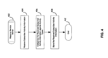
FIG. 4 is a flow chart illustrating an exemplary activity data collection procedure, in accordance with an embodiment of the invention. Referring toFIG.4 , the exemplary steps start with thestep 402, where themapping service server 200 is authorized by, for example, thesubscribers 140, to share associated subscriber activity information at a certain degree. Instep 404, themapping service server 200 receives subscriber activity information via, for example, theInternet 110a and/or some subscriber-server interactive communications. Instep 406, the received subscriber activity information is categorized against activity types. Instep 408, the categorized subscriber activity information is stored in theactivity database 206. The exemplary steps end withstep 412. -
FIG. 5 is a flow chart illustrating an exemplary activity overlay based metadata generation procedure, in accordance with an embodiment of the invention. Referring toFIG.5 , the exemplary steps start with thestep 502, where the activityoverlay search engine 204 receives subscriber service request information via themapping service processor 202. Instep 504, the activityoverlay search engine 204 is enabled to select search restrictions based on the received service request. Instep 506, the activityoverlay search engine 204 is operable to filter the activity data stored in theactivity database 204 to be used for creating metadata relating to the received service request. Instep 508, activityoverlay search engine 204 creates metadata by correlating the filtered subscriber activity data to geographic locations of interest relating to the received service request. Instep 510, the created metadata is communicated on top of a map associated with the geographic locations of interest. The exemplary steps end withstep 512. -
FIG. 6 is a block diagram illustrating an exemplary subscriber device, in accordance with an embodiment of the invention. Referring toFIG.6 , there is shown asubscriber device 600 comprising an optional Global Navigation Satellite System (GNSS)receiver 602, anetwork interface 604, aprocessor 606, amemory 608, and auser interface 610. - The
GNSS receiver 602 comprises suitable logic, circuitry and/or code that are enabled to receive Global Navigation Satellite System (GNSS) broadcast signals and convert them to corresponding GNSS baseband signals. The corresponding GNSS baseband signals are then processed by theprocessor 606 to determine positional information of thesubscriber device 600. The integration of theGNSS receiver 602 to thesubscriber device 600 is optional. In the case that thesubscriber device 600 comprises theGNSS receiver 602. TheGNSS receiver 602 is operable to provide navigation information for thesubscriber device 600 to identify associated geographical location. TheGNSS receiver 602 comprises a GPS, GALILEO and/or a GLONASS receiver. - The
network interface 604 comprises suitable logic, circuitry and/or code that are enabled to transmit and/or receive radio signals over a network such as thedata communication infrastructure 110. The network is a wired and/or wireless network. In this regard, the communicated radio signals comprise subscriber activity information from thesubscriber device 600 to themapping service servers 130 and/or activity overlay based metadata from themapping service servers 130 to thesubscriber device 600. - The
processor 606 comprises suitable logic, circuitry and/or code that are enabled to process and handle signals received from a supporting communication network and/or satellite signals from theGNSS satellite infrastructure 120. Theprocessor 606 is enabled to communicate with themapping service servers 130 for sharing associated subscriber activity information and/or gaining a desired mapping service, which comprises a list of things provided by themapping service servers 130 by overlaying subscriber activity information to geographic locations of interest indicated by thesubscriber device 600. - The
user interface 608 comprises suitable logic, circuitry and/or code that are operable to service thesubscriber device 600 via entering user inputs and/or presenting acquired mapping services to users. Theuser interface 608 comprise a microphone, a speaker, a keypad, a screen, a touch screen, a light, a voice recognition system, a camera, and/or any other type of interfaces that is employed in thesubscriber device 600. - The
memory 610 comprises suitable logic, circuitry, and/or code that enable storage of data and/or other information utilized by theprocessor 606. Thememory 610 is utilized to store information, such as algorithms that are utilized to control various operations of thesubscriber device 600. Thememory 610 stores some executable instructions for running various services on thesubscriber device 600. Various subscriber activity data, which are shared with themapping service servers 130, are stored in thememory 610. - In operation, the
subscriber device 600 gains access to themapping service servers 130 via subscriber information such as, for example, the subscriber ID and the subscriber context. Theprocessor 606 is enabled to process the activity information of thesubscriber device 600 and share with themapping service servers 130 at a certain degree. Thesubscriber 600 acquires various activity overlay based mapping services from themapping service servers 130 via thenetwork interface 604. The received mapping services are processed at theprocessor 606 to present to users in user preferred format via theuser interface 608. -
FIG. 7 is a flow chart illustrating an activity overlay based metadata acquiring procedure, in accordance with an embodiment of the invention. The exemplary steps start with thestep 702, where thesubscriber 320 gains access to themapping service server 330. Thesubscriber 320 requests a mapping service for geographic locations interested. The geographic locations interested are indicated by full or partial addresses, names, postal code, or longitude and latitude information. Instep 704, upon the receipt of the mapping service request from thesubscriber 320, themapping service server 330 selects searching restrictions based on the characteristics of the request and generates metadata by overlaying the activity data inside theactivity database 206 onto the geographic locations of interest based on the selected searching restrictions. Instep 706, the generated metadata is communicated on top of a map associated with the geographic locations of interest to thesubscriber 320. Instep 708, upon the receipt of the metadata, thesubscriber 320 presents the received metadata to users in a preferred format via theuser interface 608 and stored in thememory 610. The exemplary steps end withstep 710. - Aspects of a method and system for activity overlaid mapping services are provided. In accordance with various embodiments of the invention, a subscriber such as the GNSS enabled
cell phone 140b in the system illustrated inFIG. 1 transmits a map request to a mapping service server such as themapping service server 130a. Upon receipt of the map request from the GNSS enabledcell phone 140d, themapping service server 130a creates or generates metadata and/or enhanced maps based on subscriber activity information such as cash value of e-cash transactions and the volume of people that are using e-cash transactions collected from a plurality of subscribers associated with themapping service server 130a. The created metadata and/or enhanced maps are transmitted via the data communication infrastructure and received by the GNSS enabledcell phone 140d via thenetwork interface 604. As described inFIG.3 , the map request comprises subscriber identification information such as an identification code to gain access to themapping service server 130a. - The
mapping service server 130a is operable to request sharing corresponding subscriber activity information such as transaction value on certain items made via the GNSS enabledcell phone 140d. The GNSS enabledcell phone 140d is enabled to determine a level that the user of the GNSS enabledcell phone 140d wants to share with themapping service server 130a. The GNSS enabledcell phone 140d communicates the determined subscriber activity information sharing level with themapping service server 130a. Themapping service server 130a communicates interactively with associated plurality of subscribers to collecting subscriber activity information. As described with respect toFIG.7 , the GNSS enabledcell phone 140d requests a map from themapping service server 130a. Geographic locations of interest of the GNSS enabledcell phone 140d are included within the map request. Upon the receipt of the map request, themapping service server 130a generates or creates metadata and/or enhanced maps relating to the geographic locations of interest based on collected subscriber activity information of the plurality of subscribers associated with themapping service server 130a. The metadata and/or enhanced maps are created by correlating the collected subscriber activity information of the plurality of subscribers to the geographic locations of interest. The created metadata and/or enhanced maps are delivered to the GNSS enabledcell phone 140d via thedata communication infrastructure 110. Upon receiving the metadata and associated map, the GNSS enabledcell phone 140d present corresponding location information to users, via theuser interface 608, in a preferred format. - Another embodiment of the invention may provide a machine and/or computer readable storage and/or medium, having stored thereon, a machine code and/or a computer program having at least one code section executable by a machine and/or a computer, thereby causing the machine and/or computer to perform the steps as described herein for activity overlaid mapping services.
- Accordingly, the present invention may be realized in hardware, software, or a combination of hardware and software. The present invention may be realized in a centralized fashion in at least one computer system, or in a distributed fashion where different elements are spread across several interconnected computer systems. Any kind of computer system or other apparatus adapted for carrying out the methods described herein is suited. A typical combination of hardware and software may be a general-purpose computer system with a computer program that, when being loaded and executed, controls the computer system such that it carries out the methods described herein.
- The present invention may also be embedded in a computer program product, which comprises all the features enabling the implementation of the methods described herein, and which when loaded in a computer system is able to carry out these methods. Computer program in the present context means any expression, in any language, code or notation, of a set of instructions intended to cause a system having an information processing capability to perform a particular function either directly or after either or both of the following: a) conversion to another language, code or notation; b) reproduction in a different material form.
- While the present invention has been described with reference to certain embodiments, it will be understood by those skilled in the art that various changes may be made and equivalents may be substituted without departing from the scope of the present invention. In addition, many modifications may be made to adapt a particular situation or material to the teachings of the present invention without departing from its scope. Therefore, it is intended that the present invention not be limited to the particular embodiment disclosed, but that the present invention will include all embodiments falling within the scope of the appended claims.
Advantageously, the method further comprises accessing said mapping service server based on said subscriber identification information.
Advantageously, the method further comprises determining a level of sharing activity information of said subscriber with said mapping service server.
Advantageously, the method further comprises interacting with said mapping service server to provide activity information of said subscriber at said determined level.
Advantageously, said map request comprises geographic locations of interest to said subscriber.
Advantageously, said mapping service server creates said enhanced map relating to said geographic locations of interest to said subscriber based on said subscriber activity information of said plurality of subscribers.
Advantageously, said mapping service server creates said enhanced map by correlating said subscriber activity information of said plurality of subscribers to said geographic locations of interest to said subscriber.
Advantageously, said mapping service server delivers to said subscriber device said created enhanced map associated with said geographic locations of interest to said subscriber.
Advantageously, the method further comprises presenting said enhanced map to users of said subscriber device via a user interface.
According to an aspect, a system for communication comprises:
Advantageously, said one or more circuits are operable to accessing to said mapping service server based on said subscriber identification information.
Advantageously, said one or more circuits are operable to determine a level of sharing activity information of said subscriber with said mapping service server.
Advantageously, said one or more circuits are operable to interact with said mapping service server to provide activity information of said subscriber at said determined level.
Advantageously, said map request comprises geographic locations of interest of said subscriber.
Advantageously, said mapping service server creates said enhanced map relating to said geographic locations of interest to said subscriber based on said subscriber activity information of said plurality of subscribers.
Advantageously, said mapping service server creates said enhanced map by correlating said subscriber activity information of said plurality of subscribers to said geographic locations of interest to said subscriber.
Advantageously, said mapping service server delivers to said subscriber device said created enhanced map associated with said geographic locations of interest to said subscriber.
Advantageously, said one or more circuits are operable to present said enhanced map to users of said subscriber device via a user interface.
Claims (10)
- A method for communication, the method comprising:transmitting a map request from a subscriber device to a mapping service server serving a plurality of subscribers; andreceiving an enhanced map from said mapping service server, wherein said mapping service server creates said enhanced map in response to said map request based on subscriber activity information from said plurality of subscribers.
- The method according to claim 1, wherein said map request comprise subscriber identification information.
- The method according to claim 2, comprising accessing said mapping service server based on said subscriber identification information.
- The method according to claim 1, comprising determining a level of sharing activity information of said subscriber with said mapping service server.
- The method according to claim 4, comprising interacting with said mapping service server to provide activity information of said subscriber at said determined level.
- The method according to claim 1, wherein said map request comprises geographic locations of interest to said subscriber.
- A system for communication, the system comprising:one or more circuits for use in a subscriber device, wherein said one or more circuits are operable to transmit a map request to a mapping service server serving a plurality of subscribers; andsaid one or more circuits are operable to receive enhanced map from said mapping service server, wherein said mapping service server creates said metadata in response to said map request based on subscriber activity information from said plurality of subscribers.
- The system according to claim 7, wherein said map request comprise subscriber identification information.
- The system according to claim 8, wherein said one or more circuits are operable to accessing to said mapping service server based on said subscriber identification information.
- The system according to claim 7, wherein said one or more circuits are operable to determine a level of sharing activity information of said subscriber with said mapping service server.
Applications Claiming Priority (1)
| Application Number | Priority Date | Filing Date | Title |
|---|---|---|---|
| US12/323,424 US20100131586A1 (en) | 2008-11-25 | 2008-11-25 | Activity overlaid mapping services |
Publications (1)
| Publication Number | Publication Date |
|---|---|
| EP2189935A1 true EP2189935A1 (en) | 2010-05-26 |
Family
ID=41449956
Family Applications (1)
| Application Number | Title | Priority Date | Filing Date |
|---|---|---|---|
| EP09014371A Withdrawn EP2189935A1 (en) | 2008-11-25 | 2009-11-17 | Activity overlaid mapping services |
Country Status (5)
| Country | Link |
|---|---|
| US (1) | US20100131586A1 (en) |
| EP (1) | EP2189935A1 (en) |
| CN (1) | CN101742705B (en) |
| HK (1) | HK1145115A1 (en) |
| TW (1) | TW201101219A (en) |
Cited By (1)
| Publication number | Priority date | Publication date | Assignee | Title |
|---|---|---|---|---|
| WO2015061031A1 (en) * | 2013-10-25 | 2015-04-30 | Raytheon Company | Situational awareness personal service |
Families Citing this family (2)
| Publication number | Priority date | Publication date | Assignee | Title |
|---|---|---|---|---|
| US6859649B1 (en) * | 1999-05-07 | 2005-02-22 | Cingular Wireless Ii, Inc. | Method for registering with a communication service |
| US9247386B2 (en) | 2013-12-18 | 2016-01-26 | International Business Machines Corporation | Location-based mobile application and service selection |
Citations (4)
| Publication number | Priority date | Publication date | Assignee | Title |
|---|---|---|---|---|
| EP1339247A2 (en) * | 2002-02-26 | 2003-08-27 | Vodafone Holding GmbH | Method for drawing up data for mobile users of an information transmission system |
| US20070255831A1 (en) * | 2006-04-28 | 2007-11-01 | Yahoo! Inc. | Contextual mobile local search based on social network vitality information |
| US20080256233A1 (en) * | 2006-11-27 | 2008-10-16 | Richard Hall | System and method for tracking the network viral spread of a digital media content item |
| US20080281854A1 (en) * | 2007-05-07 | 2008-11-13 | Fatdoor, Inc. | Opt-out community network based on preseeded data |
Family Cites Families (14)
| Publication number | Priority date | Publication date | Assignee | Title |
|---|---|---|---|---|
| US7433832B1 (en) * | 1999-11-19 | 2008-10-07 | Amazon.Com, Inc. | Methods and systems for distributing information within a dynamically defined community |
| US7142205B2 (en) * | 2000-03-29 | 2006-11-28 | Autodesk, Inc. | Single gesture map navigation graphical user interface for a personal digital assistant |
| CA2820299C (en) * | 2004-03-23 | 2017-02-21 | Google Inc. | A digital mapping system |
| US7373244B2 (en) * | 2004-04-20 | 2008-05-13 | Keith Kreft | Information mapping approaches |
| EP1920393A2 (en) * | 2005-07-22 | 2008-05-14 | Yogesh Chunilal Rathod | Universal knowledge management and desktop search system |
| WO2007115273A2 (en) * | 2006-03-31 | 2007-10-11 | Geospot, Inc. | Methods for interaction, sharing, and exploration over geographical locations |
| US20070281690A1 (en) * | 2006-06-01 | 2007-12-06 | Flipt, Inc | Displaying and tagging places of interest on location-aware mobile communication devices in a local area network |
| KR100861652B1 (en) * | 2006-11-17 | 2008-10-02 | 엔에이치엔(주) | Map service system and method |
| US8121956B2 (en) * | 2007-06-25 | 2012-02-21 | Visa U.S.A. Inc. | Cardless challenge systems and methods |
| US8775420B2 (en) * | 2007-10-31 | 2014-07-08 | Yahoo! Inc. | Text display of geo-referenced information based on relative distance to a user location |
| US20110041083A1 (en) * | 2007-12-12 | 2011-02-17 | Oz Gabai | System and methodology for providing shared internet experience |
| US9706345B2 (en) * | 2008-01-04 | 2017-07-11 | Excalibur Ip, Llc | Interest mapping system |
| US7941535B2 (en) * | 2008-05-07 | 2011-05-10 | Doug Sherrets | System for targeting third party content to users based on social networks |
| WO2010042100A1 (en) * | 2008-10-06 | 2010-04-15 | The Trustees Of Princeton University | System and method for pricing and exchanging content |
-
2008
- 2008-11-25 US US12/323,424 patent/US20100131586A1/en not_active Abandoned
-
2009
- 2009-11-17 EP EP09014371A patent/EP2189935A1/en not_active Withdrawn
- 2009-11-25 CN CN200910252618.6A patent/CN101742705B/en not_active Expired - Fee Related
- 2009-11-25 TW TW098140078A patent/TW201101219A/en unknown
-
2010
- 2010-12-14 HK HK10111612.3A patent/HK1145115A1/en not_active IP Right Cessation
Patent Citations (4)
| Publication number | Priority date | Publication date | Assignee | Title |
|---|---|---|---|---|
| EP1339247A2 (en) * | 2002-02-26 | 2003-08-27 | Vodafone Holding GmbH | Method for drawing up data for mobile users of an information transmission system |
| US20070255831A1 (en) * | 2006-04-28 | 2007-11-01 | Yahoo! Inc. | Contextual mobile local search based on social network vitality information |
| US20080256233A1 (en) * | 2006-11-27 | 2008-10-16 | Richard Hall | System and method for tracking the network viral spread of a digital media content item |
| US20080281854A1 (en) * | 2007-05-07 | 2008-11-13 | Fatdoor, Inc. | Opt-out community network based on preseeded data |
Non-Patent Citations (4)
| Title |
|---|
| HAKLAY M ET AL: "OpenStreetMap: user-generated street maps", IEEE PERVASIVE COMPUTING IEEE USA, vol. 7, no. 4, October 2008 (2008-10-01), pages 12 - 18, XP011236557, ISSN: 1536-1268 * |
| MOHRAZ K ED - KI-JOUNE LI ET AL: "GEOGRAPHICAL ANALYSIS IN SAP BUSINESS INFORMATION WAREHOUSE", ACM-GIS 2000. PROCEEDINGS OF THE 8TH. ACM SYMPOSIUM ON ADVANCES IN GEOGRAPHIC INFORMATION SYSTEMS. WASHINGTON, DC, NOV. 10 - 11, 2000; [ACM INTERNATIONAL SYMPOSIUM ON ADVANCES IN GEOGRAPHIC INFORMATION SYSTEMS], NEW YORK, NY : ACM, US, vol. CONF. 8, 10 November 2000 (2000-11-10), pages 191 - 193, XP000987771, ISBN: 978-1-58113-319-6 * |
| POSTHUMUS R: "GIS as a tool in business intelligence", POSITIONIT EE PUBLISHERS (PTY.) LTD. SOUTH AFRICA, May 2008 (2008-05-01), pages 71 - 74, XP002562851 * |
| TERANISHI Y ET AL: "MapWiki: A Ubiquitous Collaboration Environment on Shared Maps", APPLICATIONS AND THE INTERNET WORKSHOPS, 2006. SAINT WORKSHOPS 2006. I NTERNATIONAL SYMPOSIUM ON PHOENIX, AZ, USA 23-27 JAN. 2006, PISCATAWAY, NJ, USA,IEEE, 23 January 2006 (2006-01-23), pages 146 - 149, XP010890196, ISBN: 978-0-7695-2510-5 * |
Cited By (2)
| Publication number | Priority date | Publication date | Assignee | Title |
|---|---|---|---|---|
| WO2015061031A1 (en) * | 2013-10-25 | 2015-04-30 | Raytheon Company | Situational awareness personal service |
| US9329262B2 (en) | 2013-10-25 | 2016-05-03 | Raytheon Company | Situational awareness personal service |
Also Published As
| Publication number | Publication date |
|---|---|
| CN101742705A (en) | 2010-06-16 |
| TW201101219A (en) | 2011-01-01 |
| HK1145115A1 (en) | 2011-04-01 |
| CN101742705B (en) | 2014-04-16 |
| US20100131586A1 (en) | 2010-05-27 |
Similar Documents
| Publication | Publication Date | Title |
|---|---|---|
| US9852462B2 (en) | Displaying location-specific images on a mobile device | |
| US9402156B2 (en) | Location based service (LBS) system and method for creating a social network | |
| US9420453B2 (en) | Correlating and mapping mobile device locations on a mobile device | |
| US7259668B2 (en) | Mapping the location of a mobile communications device systems and methods | |
| US7336964B2 (en) | Correlating activities with the location of a mobile communications device systems and methods | |
| US7515917B2 (en) | Efficiently determining the location of a mobile communications device system and methods | |
| US7221947B2 (en) | Location related keyword monitoring on a mobile communications device systems and methods | |
| US7312700B2 (en) | GPS enabled cell phone with common interest alerts | |
| WO2011034453A1 (en) | Context - triggered systems and methods for information and services | |
| US20200226695A1 (en) | Electronic business card exchange system and method using mobile terminal | |
| EP3388958B1 (en) | Method and system for managing viewability of location-based spatial object | |
| EP2189935A1 (en) | Activity overlaid mapping services | |
| US20060166684A1 (en) | GPS coordinates downloaded to GPS enabled cell phone in response to information request | |
| TW201102619A (en) | Map data management using road ghosting characteristics | |
| KR101404222B1 (en) | System and method of map servece | |
| JP2003046649A (en) | Audio location information distribution system |
Legal Events
| Date | Code | Title | Description |
|---|---|---|---|
| PUAI | Public reference made under article 153(3) epc to a published international application that has entered the european phase |
Free format text: ORIGINAL CODE: 0009012 |
|
| AK | Designated contracting states |
Kind code of ref document: A1 Designated state(s): AT BE BG CH CY CZ DE DK EE ES FI FR GB GR HR HU IE IS IT LI LT LU LV MC MK MT NL NO PL PT RO SE SI SK SM TR |
|
| AX | Request for extension of the european patent |
Extension state: AL BA RS |
|
| 17P | Request for examination filed |
Effective date: 20101126 |
|
| 17Q | First examination report despatched |
Effective date: 20110111 |
|
| STAA | Information on the status of an ep patent application or granted ep patent |
Free format text: STATUS: THE APPLICATION IS DEEMED TO BE WITHDRAWN |
|
| 18D | Application deemed to be withdrawn |
Effective date: 20170601 |