US5604765A - Position enhanced communication system including system for embedding CDMA navigation beacons under the communications signals of a wireless communication system - Google Patents
Position enhanced communication system including system for embedding CDMA navigation beacons under the communications signals of a wireless communication system Download PDFInfo
- Publication number
- US5604765A US5604765A US08/363,773 US36377394A US5604765A US 5604765 A US5604765 A US 5604765A US 36377394 A US36377394 A US 36377394A US 5604765 A US5604765 A US 5604765A
- Authority
- US
- United States
- Prior art keywords
- signals
- navigation
- communications
- gps
- cellular
- Prior art date
- Legal status (The legal status is an assumption and is not a legal conclusion. Google has not performed a legal analysis and makes no representation as to the accuracy of the status listed.)
- Expired - Lifetime
Links
Images

Classifications
-
- H—ELECTRICITY
- H04—ELECTRIC COMMUNICATION TECHNIQUE
- H04B—TRANSMISSION
- H04B1/00—Details of transmission systems, not covered by a single one of groups H04B3/00 - H04B13/00; Details of transmission systems not characterised by the medium used for transmission
- H04B1/69—Spread spectrum techniques
-
- G—PHYSICS
- G01—MEASURING; TESTING
- G01C—MEASURING DISTANCES, LEVELS OR BEARINGS; SURVEYING; NAVIGATION; GYROSCOPIC INSTRUMENTS; PHOTOGRAMMETRY OR VIDEOGRAMMETRY
- G01C21/00—Navigation; Navigational instruments not provided for in groups G01C1/00 - G01C19/00
- G01C21/20—Instruments for performing navigational calculations
- G01C21/206—Instruments for performing navigational calculations specially adapted for indoor navigation
-
- G—PHYSICS
- G01—MEASURING; TESTING
- G01S—RADIO DIRECTION-FINDING; RADIO NAVIGATION; DETERMINING DISTANCE OR VELOCITY BY USE OF RADIO WAVES; LOCATING OR PRESENCE-DETECTING BY USE OF THE REFLECTION OR RERADIATION OF RADIO WAVES; ANALOGOUS ARRANGEMENTS USING OTHER WAVES
- G01S1/00—Beacons or beacon systems transmitting signals having a characteristic or characteristics capable of being detected by non-directional receivers and defining directions, positions, or position lines fixed relatively to the beacon transmitters; Receivers co-operating therewith
- G01S1/02—Beacons or beacon systems transmitting signals having a characteristic or characteristics capable of being detected by non-directional receivers and defining directions, positions, or position lines fixed relatively to the beacon transmitters; Receivers co-operating therewith using radio waves
- G01S1/68—Marker, boundary, call-sign, or like beacons transmitting signals not carrying directional information
-
- G—PHYSICS
- G01—MEASURING; TESTING
- G01S—RADIO DIRECTION-FINDING; RADIO NAVIGATION; DETERMINING DISTANCE OR VELOCITY BY USE OF RADIO WAVES; LOCATING OR PRESENCE-DETECTING BY USE OF THE REFLECTION OR RERADIATION OF RADIO WAVES; ANALOGOUS ARRANGEMENTS USING OTHER WAVES
- G01S19/00—Satellite radio beacon positioning systems; Determining position, velocity or attitude using signals transmitted by such systems
- G01S19/01—Satellite radio beacon positioning systems transmitting time-stamped messages, e.g. GPS [Global Positioning System], GLONASS [Global Orbiting Navigation Satellite System] or GALILEO
- G01S19/03—Cooperating elements; Interaction or communication between different cooperating elements or between cooperating elements and receivers
- G01S19/10—Cooperating elements; Interaction or communication between different cooperating elements or between cooperating elements and receivers providing dedicated supplementary positioning signals
- G01S19/11—Cooperating elements; Interaction or communication between different cooperating elements or between cooperating elements and receivers providing dedicated supplementary positioning signals wherein the cooperating elements are pseudolites or satellite radio beacon positioning system signal repeaters
-
- G—PHYSICS
- G01—MEASURING; TESTING
- G01S—RADIO DIRECTION-FINDING; RADIO NAVIGATION; DETERMINING DISTANCE OR VELOCITY BY USE OF RADIO WAVES; LOCATING OR PRESENCE-DETECTING BY USE OF THE REFLECTION OR RERADIATION OF RADIO WAVES; ANALOGOUS ARRANGEMENTS USING OTHER WAVES
- G01S19/00—Satellite radio beacon positioning systems; Determining position, velocity or attitude using signals transmitted by such systems
- G01S19/01—Satellite radio beacon positioning systems transmitting time-stamped messages, e.g. GPS [Global Positioning System], GLONASS [Global Orbiting Navigation Satellite System] or GALILEO
- G01S19/13—Receivers
- G01S19/21—Interference related issues ; Issues related to cross-correlation, spoofing or other methods of denial of service
-
- G—PHYSICS
- G01—MEASURING; TESTING
- G01S—RADIO DIRECTION-FINDING; RADIO NAVIGATION; DETERMINING DISTANCE OR VELOCITY BY USE OF RADIO WAVES; LOCATING OR PRESENCE-DETECTING BY USE OF THE REFLECTION OR RERADIATION OF RADIO WAVES; ANALOGOUS ARRANGEMENTS USING OTHER WAVES
- G01S19/00—Satellite radio beacon positioning systems; Determining position, velocity or attitude using signals transmitted by such systems
- G01S19/38—Determining a navigation solution using signals transmitted by a satellite radio beacon positioning system
- G01S19/39—Determining a navigation solution using signals transmitted by a satellite radio beacon positioning system the satellite radio beacon positioning system transmitting time-stamped messages, e.g. GPS [Global Positioning System], GLONASS [Global Orbiting Navigation Satellite System] or GALILEO
- G01S19/42—Determining position
- G01S19/45—Determining position by combining measurements of signals from the satellite radio beacon positioning system with a supplementary measurement
- G01S19/46—Determining position by combining measurements of signals from the satellite radio beacon positioning system with a supplementary measurement the supplementary measurement being of a radio-wave signal type
-
- G—PHYSICS
- G01—MEASURING; TESTING
- G01S—RADIO DIRECTION-FINDING; RADIO NAVIGATION; DETERMINING DISTANCE OR VELOCITY BY USE OF RADIO WAVES; LOCATING OR PRESENCE-DETECTING BY USE OF THE REFLECTION OR RERADIATION OF RADIO WAVES; ANALOGOUS ARRANGEMENTS USING OTHER WAVES
- G01S5/00—Position-fixing by co-ordinating two or more direction or position line determinations; Position-fixing by co-ordinating two or more distance determinations
- G01S5/02—Position-fixing by co-ordinating two or more direction or position line determinations; Position-fixing by co-ordinating two or more distance determinations using radio waves
- G01S5/0205—Details
- G01S5/0236—Assistance data, e.g. base station almanac
-
- G—PHYSICS
- G01—MEASURING; TESTING
- G01S—RADIO DIRECTION-FINDING; RADIO NAVIGATION; DETERMINING DISTANCE OR VELOCITY BY USE OF RADIO WAVES; LOCATING OR PRESENCE-DETECTING BY USE OF THE REFLECTION OR RERADIATION OF RADIO WAVES; ANALOGOUS ARRANGEMENTS USING OTHER WAVES
- G01S5/00—Position-fixing by co-ordinating two or more direction or position line determinations; Position-fixing by co-ordinating two or more distance determinations
- G01S5/02—Position-fixing by co-ordinating two or more direction or position line determinations; Position-fixing by co-ordinating two or more distance determinations using radio waves
- G01S5/14—Determining absolute distances from a plurality of spaced points of known location
- G01S5/145—Using a supplementary range measurement, e.g. based on pseudo-range measurements
-
- H—ELECTRICITY
- H04—ELECTRIC COMMUNICATION TECHNIQUE
- H04B—TRANSMISSION
- H04B15/00—Suppression or limitation of noise or interference
-
- H—ELECTRICITY
- H04—ELECTRIC COMMUNICATION TECHNIQUE
- H04L—TRANSMISSION OF DIGITAL INFORMATION, e.g. TELEGRAPHIC COMMUNICATION
- H04L27/00—Modulated-carrier systems
- H04L27/10—Frequency-modulated carrier systems, i.e. using frequency-shift keying
- H04L27/103—Chirp modulation
-
- H—ELECTRICITY
- H04—ELECTRIC COMMUNICATION TECHNIQUE
- H04Q—SELECTING
- H04Q9/00—Arrangements in telecontrol or telemetry systems for selectively calling a substation from a main station, in which substation desired apparatus is selected for applying a control signal thereto or for obtaining measured values therefrom
-
- H—ELECTRICITY
- H04—ELECTRIC COMMUNICATION TECHNIQUE
- H04B—TRANSMISSION
- H04B1/00—Details of transmission systems, not covered by a single one of groups H04B3/00 - H04B13/00; Details of transmission systems not characterised by the medium used for transmission
- H04B1/69—Spread spectrum techniques
- H04B2001/6912—Spread spectrum techniques using chirp
-
- H—ELECTRICITY
- H04—ELECTRIC COMMUNICATION TECHNIQUE
- H04L—TRANSMISSION OF DIGITAL INFORMATION, e.g. TELEGRAPHIC COMMUNICATION
- H04L5/00—Arrangements affording multiple use of the transmission path
- H04L5/003—Arrangements for allocating sub-channels of the transmission path
- H04L5/0048—Allocation of pilot signals, i.e. of signals known to the receiver
-
- H—ELECTRICITY
- H04—ELECTRIC COMMUNICATION TECHNIQUE
- H04L—TRANSMISSION OF DIGITAL INFORMATION, e.g. TELEGRAPHIC COMMUNICATION
- H04L5/00—Arrangements affording multiple use of the transmission path
- H04L5/003—Arrangements for allocating sub-channels of the transmission path
- H04L5/0053—Allocation of signaling, i.e. of overhead other than pilot signals
-
- H—ELECTRICITY
- H04—ELECTRIC COMMUNICATION TECHNIQUE
- H04L—TRANSMISSION OF DIGITAL INFORMATION, e.g. TELEGRAPHIC COMMUNICATION
- H04L5/00—Arrangements affording multiple use of the transmission path
- H04L5/14—Two-way operation using the same type of signal, i.e. duplex
- H04L5/1469—Two-way operation using the same type of signal, i.e. duplex using time-sharing
Definitions
- Wireless communications are rapidly augmenting conventional telephone communications.
- emergency 911 service has been in existence for a number of years and has evolved and been upgraded over time.
- an "Enhanced 911" service is available.
- the emergency center receiving the call automatically learns the phone number, location and identity of the calling party. Such information is necessary for rapidly dispatching the required help to the correct location, and for call-back to the party that reported the emergency, if required.
- Enhanced 911 is so common, that there is an expectation and assumption by the public, that such service is available in the wireless world.
- Enhanced 911 service does not exist for cellular telephony which is the most mature wireless communication system in the United States.
- an emergency center that receives a call dialed from a cellular telephone, has no idea where the party is calling from and does not know the phone number or identity of the phone subscriber. Furthermore, there exists no infrastructure or standard for providing Enhanced 911 service in cellular and other wireless communications systems.
- Determining the position of the calling terminal making a wireless call is a key requirement for providing Enhanced 911.
- a number of alternatives for determining position of a caller are based upon the calling terminal estimating its position with the support of auxiliary equipment and/or the use of broadcast RF beacons. Available options for position location at the calling terminal are as follows:
- Broadcast Navigation RF Beacons GPS and Loran are two examples.
- Base Station to Mobile/Portable Terminal Broadcasts as Navigation Beacon Surrogates such as using the broadcasts from multiple cellular base stations.
- Dead Reckoning and other forms of Inertial Navigation such as using the speedometer output of a vehicle in combination with a gyroscope to detect turns.
- Mobile terminals are defined as those that are installed in and operate from vehicles. Thus the locations for the mobile environment are restricted to places that a vehicle may go.
- Portable terminals are defined as hand-held devices and so portables will be used anywhere that a person may go with or without a vehicle. Thus mobiles and portables are different insofar as the places that they are required to operate in. Mobiles must work primarily on streets and highways where there is often a clear view of the GPS constellation; and when there is not, such as in the "urban canyon,” GPS position fixing is still possible, albeit on an interrupted basis.
- mobiles unlike portables
- the vehicle that hosts the mobile can support the power required for continuous position fixing; they can support the equipment needed for dead reckoning; and finally, they provide a platform on which to attach antennas (i.e., GPS) that must be mounted in a fixed orientation.
- the object of this invention is to provide a system with world-wide capability for position determination via broadcast of RF navigation signals.
- the overall system comprises the following three elements: 1) the GPS system, 2) GPS-like signals broadcast at an alternative frequency, and 3) GPS-like RF signposts.
- the first element of the system provides world-wide positioning as long as the view to the GPS constellation is not obstructed.
- a receiver determines its position by measuring the pseudorange of spread spectrum signals broadcast by the GPS satellites at 1575.42 MHz.
- the second element is the novel concept embedding GPS-like signals within the communications bandwidth of a wireless communications systems. This is similar to the concept of GPS pseudolites that have been proposed for aviation navigation, but the navigation signals proposed here are not at GPS frequencies.
- the concept is flexible so that a variety of existing communications systems can have embedded navigation signals. Because of its widespread implementation, the US cellular telephone system is a particularly attractive environment for embedding navigation signals. However, the concept of embedded navigation signals applies to digital TDMA and CDMA cellular, GSM, and emerging systems in the PCS bands as well as those that operate in the ISM bands.
- the position determination supported by this second element serves as a supplement or replacement of the GPS system in any region or environment that is covered by that wireless communication system. This includes the urban canyon, but also indoor environments such as shopping malls and buildings which are serviceable by cellular telephone and other wireless communications systems.
- a GPS-like receiver in the mobile/portable communications transceiver makes pseudorange measurements on the broadcast sources and calculates the position of the receiver from these measurements. The operation of this system is described below.
- the third element is another novel concept that involves the use of GPS-like RF broadcasts that mark the location of the broadcast.
- the range of this broadcast is designed to be short ( ⁇ 100 feet) so that the mere reception of this broadcast and reading the data location marker in the signal determines the position of the receiver to within 100 ft.
- These broadcast signals are referred to as RF Signposts.
- RF Signposts can be used indoors and can successfully convey address and floor of a building or locations in a shopping mall, etc., while ranging systems that are inherently corrupted by severe multipath in the indoor environment cannot.
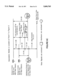
- FIG. 1 is a block diagram of a cellular base station having incorporated therein a navigation signal generator
- FIG. 2 is a diagram depicting the overall system for seamless and comprehensive position locations
- FIG. 3 is a diagram illustrating a mobile terminal taking pseudorange measurements to three cellular telephone base stations
- FIG. 4a is a diagrammatic analysis of the impact of a spread spectrum navigation signal on the signal-to-noise ratio (SNR) of a conventional communications signal
- FIG. 4b is a diagrammatic analysis of the impact of a set of communication signals on the SNR of a navigation signal
- FIG. 5 is an illustration of a mobile terminal in a 7-cell cluster of a cellular communication system
- FIG. 6a is an analysis of the impact of navigation signals on the SNR of a communications signal with the mobile unit being located at Point E in FIG. 5,
- FIG. 6b is an analysis of the impact of the communication signals on the SNR of a navigation signal when the mobile unit is located at Point E in FIG. 5,
- FIG. 6c is an analysis of the impact of a navigation signal from a far base station with the mobile unit at Point F in FIG. 5,
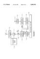
- FIG. 7 is a block diagram of one configuration of a navigation signal generator embedded in a cellular base station
- FIG. 8a is a block diagram of a low power RF position signpost
- FIG. 8b is a diagrammatic layout of a large building in which the position signposts are distributed.
- FIG. 8c is a diagrammatic layout of a large shopping mall or center where the RF position signposts are distributed at fixed locations
- FIG. 9 is a block diagram of one embodiment of a communication terminal with universal position determination capability.
- Application Ser. No. 08/203,257 discloses the use of commercial radio and TV broadcast signals to supplement or even replace GPS positioning in environments where the GPS signals are frequently blocked, or do not penetrate at all.
- the present invention incorporates another alternative for supplementing or replacing GPS that involves adding a GPS-like navigation signal to the communications broadcasts from cellular and other wireless base station transmitters.
- the navigation signal may simultaneously reside in the same frequency band that is used to carry the communications channels.
- it is possible to set the navigation (location or position) signal low enough to have no interference impact on the communications, while at the same time, be high enough to be detected, tracked, and support a data rate of 50 bps.
- the proposed navigation signal is a direct sequence spread spectrum waveform with a chipping rate of 1.023 Mcps and thus occupies a bandwidth (null to null) of about 2 MHz.
- the chipping phase would be synchronized to a uniform time base and, preferably, is slaved to the GPS system (see FIG. 7).
- the information payload of 50 bps would include such data as the position of the broadcast tower, time markers, and ancillary data to correct phase and frequency offsets of the signal.
- FIG. 3 shows a mobile user MU enclosed or bounded within 3 base stations 10-1, 10-2, 10-3 of a cellular communications system.
- the mobile unit MU tracks the navigation signals from at least 3 base stations and measures the pseudorange to each of them. Measurements from three base stations are required for a 2D solution and if a 3D solution is desired, then measurements from 4 base stations are required. For the 2D case this may be understood as follows:
- the RF Signpost navigation signal of this invention is a direct sequence spread spectrum waveform with a chipping rate of 1.023 Mcps and thus occupies a bandwidth (null to null) of about 2 MHz.
- the chipping phase would not have to be synchronized with any time base so that the cost of an RF Signpost would be very low.
- the data source 8-1 supplied with position or location information (floor, shops, wing, etc. of a building, or walkway, shops, etc. and direction in a shopping mall) is stored in an EPROM 8-2 or other data storage device encoded 8-3 with a PN code 8-4 and phase modulator 8-5 on a carrier 8-6, and broadcast at very low power by antenna 8-7.
- the information payload of 50 bps would include, at a minimum, data that conveys the position of the signpost.
- the position data would include a signpost ID which would map to an address based position (e.g., 100 Simeon Way, 10th floor, suite #1024) and possibly also to a 3D coordinate position.
- the RF Signposts are of sufficiently low power so that they have a very limited range.
- the transmission of a Signpost ID would convey the fact that the mobile/portable terminal is within some 100 feet or so of the signpost.
- the frequency of the RF Signpost broadcast is flexible. In the indoors, the Signposts could actually be at the GPS frequency w/o causing interference to the signals broadcast by the GPS constellation. Signposts can also broadcast at the communications frequencies (of cellular and PCS systems) as well as at ISM frequencies. In addition, Signposts may also be broadcast in signal structures that are different from that of GPS.
- This section illustrates how navigation signals may be embedded under the communications signals of a communications system without causing any significant mutual interference between the two signals.
- FIG. 4 the analysis is shown for broadcasts from a single source.
- FIG. 6 the interference analysis is expanded to include broadcasts from multiple base stations within a cellular system.
- the AMPS cellular telephone communications system is assumed, but the methodology and results are applicable to any similar communications system, both analog and digital. In fact, the invention will work whenever the following constraint can be obeyed:
- SNR C and SNR N are the desired signal to noise ratios for the communications and navigation signals, respectively.
- the navigation signals In order to support the required pseudorange measurements, the navigation signals must be broadcast at a level such that the signal to noise ratios (SNR) of the communications channels are not affected, but the SNR of the navigation signal is sufficient to support 50 bps.
- SNR signal to noise ratios
- the noise term in the SNR is assumed to include interference terms as well as contribution from thermal noise.
- I C Interference to E C from other communications channels of the system; this includes:
- the communications signal to noise is typically 18 dB or greater in order to support good voice quality. This is illustrated in the signal level diagram in FIG. 4a. Now imagine an additional navigation signal with an energy E N that is spread across M communications channels. In such a case the signal to noise ratio of the communications signals are degraded slightly as follows: ##EQU3##
- the level of E N /M be set 10 dB below the level of I C (or 28 dB below E C ) so that the impact of a navigation signal on the communications signal to noise ratio is negligible.
- the set magnitude of E N is sufficiently high so that the signal to noise ratio of the navigation signal can support a 50 bps data rate.
- the navigation signal to noise may be derived by noting that the sum of the communications signal energy and interference (E C +I C ) divided by the communications bandwidth (B C ) acts as an additional term to the noise spectral density.
- the signal to noise density of the navigation signal to noise ratio is as follows: ##EQU4## where B N is the noise bandwidth associated with the 50 bps data rate of the navigation signal.
- E C dominates I C so that the navigation SNR is very nearly approximated as follows: ##EQU5##
- this signal to noise ratio is 15 dB and thus is easily able to support reliable data transfer.
- the navigation signal is 15 dB higher than the communications signals are above their respective thermal noise floors.
- the navigation signals should have the same or better margin for building penetration as the communications signals.
- each base station uses roughly 1/7 of the allocated spectrum and that the channels used by each base station are distributed throughout the spectrum. This assumption is roughly consistent with channel assignment in the current AMPS cellular telephone system.
- each base station transmits communications signals on 1/7 of the spectrum.
- the interference analysis is considered at two positions: E and F.
- E is a worst case for the interference impact of the navigation signals on the communications signals and it determines the relative level that the navigation signals must be set at.
- the analysis at point F is a worst case for the interference impact of the communications signals have on the navigation signal.
- FIG. 6b the interference analysis at point E of the communications signals on the navigation signals is illustrated.
- the three surrounding base stations have communications channels that occupy 3/7 of the 2 MHz band.
- the navigation SNR is as approximately expressed as follows: ##EQU7##
- FIG. 6c shows the results of the interference analysis of the communications signals on the navigation signals when the mobile is at point F. In particular, this shows the analysis for receiving a navigation signal that is transmitted by one of the adjacent base stations that is relatively far away and therefore suffers a range loss.
- the range loss differential is accounted for by adding a gain coefficient G on all the signals broadcast by base station #1.
- FIG. 6c indicates that the SNR between this and navigation signal and this source is 12.5 dB.
- the SNR is about 20.5 dB-10 logG. This term is clearly problematic since it says that whenever G is as large as 10, the SNR is less than 10 dB and we cannot operate reliably. In typical cellular systems, the differential range losses are much larger than 10. This would mean that whenever the mobile was close to a base station, the navigation signals of the adjacent stations would be jammed and only the local navigation signal could be received. This interference situation can be significantly ameliorated if the local navigation signal broadcasts the channel numbers of the occupied communications frequencies. Then, the mobile receiver for the navigation signals could notch out the occupied frequencies, thereby greatly reducing the interference. The penalty for this action is a signal loss of 1/7 or about 0.7 dB. With such a loss, the 12.5 dB SNR with respect to the first interference source would be reduced to just below 12 dB.
- the navigation signal from base station #1 is 10 logG above a navigation signal from an adjacent base station.
- the SNR of a weak navigation signal with respect to interference from a strong navigation signal is 43 dB-10 logG. This leads to a good SNR even with G as large as 1000.
- the coverage can be further improved by addressing the problem of rear broadcasts interfering with a broadcast from a far base station.
- multiple frequencies (3 at a minimum) can be for navigation signals and allocated so that no neighboring base stations broadcast at the same frequency
- navigation signals can be pulsed in coordination with adjacent base stations so that adjacent base stations do not broadcast simultaneously (e.g., in 3 second cycles in which 3 adjacent stations take turns with broadcasting of 1 second duration.
- the base station includes a source 7-10 of conventional base station communication transmit signals which are supplied via summer 7-11 to conventional base station transmitter 7-12 and broadcast on base station antenna 7-13 in the usual manner for any given cellular telephone system.
- the present invention embeds the CDMA navigation beacon discussed above under the communication signals at the base station.
- a GPS antenna 7-15 supplies GPS signals to the conventional GPS RF front end 7-16 and conventional pseudorange computations in 7-17 and time/frequency determinations 7-18 provided to microcontroller 7-20, which has a non-volatile RAM. Data for that base station (such as station identity, location, etc.
- the strength of the navigation signal is set so that the combined interference from a predetermined number N of navigation signals at any point is at least a predetermined level below the energy in the communication channel. In the embodiment illustrated in FIG. 7, the level is set by control amplifier 7-23.
- the controlled signal level of the navigation (location or position) signal is summed in summer 7-11 with the conventional base station communication signals and then processed and broadcast in the usual manner.
- FIG. 9 illustrates the logical block diagram of the most general terminal that would be used for position determination.
- the diplexer 9-21, amplifier 9-24S, 9-24R, modulator 9-25, demodulator 9-26 are conventional. Note that there are three potential RF paths into the terminal. Path A (from coupler 9-10, amplifier 9-11, and filter and downconverter 9-12) intercepts navigation signals that are embedded within the communication frequencies and pseudorange measurements made in 9-13 from which a position calculation 9-14 is made and provided to microcontroller 9-15, and utilization device 9-16, which may be a display (LCD or printed) a recorder, or a speaker.
- Path B includes GPS RF front end 9-17 which intercepts the navigation signals from the GPS satellites with an antenna and low-noise pre-amplifier in the RF front end. Path B could also receive transmissions of the RF Signposts as well, if on that frequency. Finally, path C uses an RF path at an alternative frequency (e.g., 900 MHz ISM) to receive, either GPS-like signals or other Signpost signals at that frequency. Note that all three paths, A, B, and C have separate front ends, but share the middle and end stages of the GPS receiver that:
- the terminal In regions where there are no RF navigation signals other than GPS, the terminal will determine its position via the GPS constellation.
- the GPS receiver has an interface with communications terminal so that position can be sent via a control channel or assigned channel of the communication system.
- the terminal When the terminal is in a region where the communications system provides embedded navigation signals, the terminal receives these signals via the same antenna 9-20 and diplexer 9-21 as for communication signals. Some of the received signal power split off by coupler 9-10 at the receiver front end for the processing of the navigation signals. After filtering and downconversion 9-12 to a common IF, the received signal is routed to the Pseudorange Measurement stage 9-13 of the GPS receiver. Typically, the strongest signal will be acquired and demodulated first. Sometimes, as discussed above, when a mobile/portable is near the base station, the communications broadcast will jam the navigation signals from more distant base stations. However, the navigation signal from the same base station will always be strong enough to be demodulated.
- This signal will have data that identifies the occupied communication channels of the nearby base station.
- the receiver will implement a notch filter within the 2 MHz band of the navigation signal that will effectively eliminate the interference of the strong communications signals. In this manner, the receiver will be capable of simultaneously measuring the pseudorange to multiple stations, even when the receiver may be quite near a base station.
- the signal will be received and demodulated along path C.
- the position may be also determined from multiple RF signals. For example, at an indoor location with a region served by a cellular communications system with navigation signals, the receiver will typically determine a position via pseudorange measurements. However, if the building contains RF Signposts, the receiver will also have a position of the last Signpost seen. This is advantageous for two reasons:
- the Signpost data will contain an ID and other information that will map to a building address, floor number, or even suite.
- the communications terminal in FIG. 9 will make a positioning measurement as described.
- the terminal will convey the position to the communications system (e.g., using the control/set-up channel in amps).
- the communications system can route the call based on knowledge of position, and may also provide that position to the call destination.
- the communications terminal can also send the position to the call destination.
- position capabilities the requirement of Enhanced 911 to know the position of a calling terminal is satisfied.
- These capabilities can also support the services of roadside assistance and fleet management via other special dialing codes.
- positional information is embedded in all calls, this capability can also deter theft, fraud and abuse of wireless communications services.
- DSSS direct sequence spread spectrum
- a 3 frequency system would be comprised of a center frequency and a frequency on either side offset by about 1 MHz (e.g. in the first null).
- the integrated system composed of GPS, navigation beacon broadcasts in a cellular coverage, and RF Signpost broadcasts, that provide seamless positioning worldwide in outdoor and indoor environments.
- CDMA navigation or position information embedded in the communication signals of the wireless communications system can be used separately without any GPS channels and without the RF signpost feature.
Abstract
Description
Spreading Gain>SNR.sub.c ·SNR.sub.N
Claims (8)
Spreading Gain>SNR.sub.C ·SNR.sub.N
Priority Applications (8)
| Application Number | Priority Date | Filing Date | Title |
|---|---|---|---|
| US08/363,773 US5604765A (en) | 1994-12-23 | 1994-12-23 | Position enhanced communication system including system for embedding CDMA navigation beacons under the communications signals of a wireless communication system |
| US08/393,312 US6111538A (en) | 1994-12-23 | 1995-02-23 | Cellular positioning system (CPS) |
| US08/393,410 US5701328A (en) | 1994-12-23 | 1995-02-23 | Chirped spread spectrum positioning system |
| AU46845/96A AU4684596A (en) | 1994-12-23 | 1995-12-21 | Position enhanced communication system |
| PCT/US1995/016019 WO1996020542A1 (en) | 1994-12-23 | 1995-12-21 | Position enhanced communication system |
| US08/754,406 US6160837A (en) | 1994-12-23 | 1996-11-21 | Method of avoiding near-far interference problems in an array of navigation signal beacons having selected CDMA or GPS-like navigation signals |
| US09/716,370 US6850734B1 (en) | 1994-12-23 | 2000-11-21 | Position enhanced communication system including system for embedding CDMA navigation beacons under the communications signals of a wireless communication system |
| US10/230,104 USRE38808E1 (en) | 1994-12-23 | 2002-08-29 | Cellular positioning system (CPS) |
Applications Claiming Priority (2)
| Application Number | Priority Date | Filing Date | Title |
|---|---|---|---|
| US08/363,773 US5604765A (en) | 1994-12-23 | 1994-12-23 | Position enhanced communication system including system for embedding CDMA navigation beacons under the communications signals of a wireless communication system |
| US08/393,312 US6111538A (en) | 1994-12-23 | 1995-02-23 | Cellular positioning system (CPS) |
Related Child Applications (3)
| Application Number | Title | Priority Date | Filing Date |
|---|---|---|---|
| US08/393,312 Continuation-In-Part US6111538A (en) | 1994-12-23 | 1995-02-23 | Cellular positioning system (CPS) |
| US08/393,410 Continuation-In-Part US5701328A (en) | 1994-12-23 | 1995-02-23 | Chirped spread spectrum positioning system |
| US08/754,406 Division US6160837A (en) | 1994-12-23 | 1996-11-21 | Method of avoiding near-far interference problems in an array of navigation signal beacons having selected CDMA or GPS-like navigation signals |
Publications (1)
| Publication Number | Publication Date |
|---|---|
| US5604765A true US5604765A (en) | 1997-02-18 |
Family
ID=35005252
Family Applications (3)
| Application Number | Title | Priority Date | Filing Date |
|---|---|---|---|
| US08/363,773 Expired - Lifetime US5604765A (en) | 1994-12-23 | 1994-12-23 | Position enhanced communication system including system for embedding CDMA navigation beacons under the communications signals of a wireless communication system |
| US08/393,312 Ceased US6111538A (en) | 1994-12-23 | 1995-02-23 | Cellular positioning system (CPS) |
| US10/230,104 Expired - Lifetime USRE38808E1 (en) | 1994-12-23 | 2002-08-29 | Cellular positioning system (CPS) |
Family Applications After (2)
| Application Number | Title | Priority Date | Filing Date |
|---|---|---|---|
| US08/393,312 Ceased US6111538A (en) | 1994-12-23 | 1995-02-23 | Cellular positioning system (CPS) |
| US10/230,104 Expired - Lifetime USRE38808E1 (en) | 1994-12-23 | 2002-08-29 | Cellular positioning system (CPS) |
Country Status (1)
| Country | Link |
|---|---|
| US (3) | US5604765A (en) |
Cited By (119)
| Publication number | Priority date | Publication date | Assignee | Title |
|---|---|---|---|---|
| WO1997028455A1 (en) * | 1996-02-01 | 1997-08-07 | Stanford Telecommunications, Inc. | Radio navigation system using out-of-band pseudolites |
| WO1998008321A1 (en) * | 1996-08-19 | 1998-02-26 | Motorola Inc. | Apparatus and method for providing a beacon signal in a wireless communication system |
| US5864764A (en) * | 1996-11-25 | 1999-01-26 | Motorola, Inc. | Infrastructure transceiver and method for configuration based on location information |
| WO1999048233A1 (en) * | 1998-03-20 | 1999-09-23 | Ksi Inc. | Pseudolite-augmented gps for locating wireless telephones |
| US5982324A (en) * | 1998-05-14 | 1999-11-09 | Nortel Networks Corporation | Combining GPS with TOA/TDOA of cellular signals to locate terminal |
| US5999124A (en) * | 1998-04-22 | 1999-12-07 | Snaptrack, Inc, | Satellite positioning system augmentation with wireless communication signals |
| US5999126A (en) * | 1996-08-06 | 1999-12-07 | Sony Corporation | Position measuring apparatus, position measuring method, navigation apparatus, navigation method, information service method, automotive vehicle, and audio information transmitting and receiving method |
| US6094168A (en) * | 1995-09-19 | 2000-07-25 | Cambridge Positioning Systems Ltd. | Position determining system |
| US6122268A (en) * | 1996-06-18 | 2000-09-19 | Nec Corporation | Method for allocating geographical identifier and network corresponding to movable hosts |
| US6215998B1 (en) | 1997-12-11 | 2001-04-10 | Nortel Networks Limited | Local component-specific console |
| WO2001032480A1 (en) * | 1999-11-05 | 2001-05-10 | Netstar (Proprietary) Limited | A mobile object monitoring system |
| US6236365B1 (en) | 1996-09-09 | 2001-05-22 | Tracbeam, Llc | Location of a mobile station using a plurality of commercial wireless infrastructures |
| US6236359B1 (en) * | 1998-05-14 | 2001-05-22 | Nortel Networks Limited | Cellular terminal location using GPS signals in the cellular band |
| US6249245B1 (en) * | 1998-05-14 | 2001-06-19 | Nortel Networks Limited | GPS and cellular system interworking |
| WO2001050151A1 (en) * | 2000-01-06 | 2001-07-12 | Brightcom Technologies Ltd. | Integration of bluetooth functionality with a global positioning system |
| EP1122554A1 (en) * | 2000-01-31 | 2001-08-08 | Sony Corporation | Gps receiver and portable communication apparatus |
| US6285663B1 (en) * | 1998-06-05 | 2001-09-04 | Telefonaktiebolaget Lm Ericsson (Publ) | Increasing performance in communications by embedding one signal in another signal |
| EP1139690A1 (en) * | 2000-03-29 | 2001-10-04 | Sagem S.A. | Method for determining the location of a mobile phone |
| EP1143261A1 (en) * | 2000-03-30 | 2001-10-10 | Honda Giken Kogyo Kabushiki Kaisha | Method for detecting the position of a moving body |
| JP2001285926A (en) * | 2000-03-03 | 2001-10-12 | Lucent Technol Inc | Base station positioning system im wireless communication system, and method for enhancing accuracy of received navigation satellite signal in cellular phone handset, and navigation system |
| WO2001095511A1 (en) * | 2000-06-08 | 2001-12-13 | Motorola Inc. | Method and apparatus for location determination of a cellular telephone |
| US20010055975A1 (en) * | 2000-03-25 | 2001-12-27 | Mcdonnell James Thomas Edward | Providing location data about a mobile entity |
| US20020022490A1 (en) * | 2000-04-20 | 2002-02-21 | Nec Corporation | Mobile telephone system capable of effectively utilizing GPS information even if direct reception by a mobile telephone apparatus is difficult |
| US6351647B1 (en) * | 1996-10-30 | 2002-02-26 | Nokia Telecommunications Oy | Location-dependent services in a mobile communication system |
| US6408019B1 (en) | 1997-12-29 | 2002-06-18 | Georgia Tech Research Corporation | System and method for communication using noise |
| US20020110151A1 (en) * | 2000-08-21 | 2002-08-15 | Dickey Sergey L. | Method and apparatus for CDMA pn scanning at indoor and other obstructed locations |
| US20020144294A1 (en) * | 2001-02-02 | 2002-10-03 | Matthew Rabinowitz | Position location using terrestrial digital video broadcast television signals |
| US6484095B2 (en) | 2000-06-06 | 2002-11-19 | Satellite Devices Ltd. | Vehicle operation and position recording system incorporating GPS |
| US6484096B2 (en) * | 2000-06-06 | 2002-11-19 | Satellite Devices Limited | Wireless vehicle monitoring system |
| US20020184653A1 (en) * | 2001-02-02 | 2002-12-05 | Pierce Matthew D. | Services based on position location using broadcast digital television signals |
| US20020199196A1 (en) * | 2001-06-21 | 2002-12-26 | Matthew Rabinowitz | Position location using global positioning signals augmented by broadcast television signals |
| US6529165B1 (en) | 1999-06-01 | 2003-03-04 | Cambridge Positioning Systems, Ltd. | Radio positioning systems |
| US20030043069A1 (en) * | 2001-08-30 | 2003-03-06 | Denso Corporation | Wireless communications terminal, computer program executable by wireless communications terminal and method for outputting positional information from wireless communications terminal |
| US20030052822A1 (en) * | 2001-02-02 | 2003-03-20 | Matthew Rabinowitz | Position location using broadcast digital television signals |
| US6538601B2 (en) | 2001-02-27 | 2003-03-25 | Itt Manufacturing Enterprises, Inc. | Hybrid system for position determination by a mobile communications terminal |
| WO2003027703A2 (en) * | 2001-09-26 | 2003-04-03 | Itt Manufacturing Enterprises, Inc. | An embedded chirp signal for position determination in cellular communication systems |
| US20030146871A1 (en) * | 1998-11-24 | 2003-08-07 | Tracbeam Llc | Wireless location using signal direction and time difference of arrival |
| US20030156063A1 (en) * | 2001-08-17 | 2003-08-21 | Spilker James J. | Position location using integrated services digital broadcasting - terrestrial (ISDB-T) broadcast television signals |
| US20030222820A1 (en) * | 1996-09-09 | 2003-12-04 | Tracbeam Llc | Wireless location using hybrid techniques |
| US20030231133A1 (en) * | 2001-02-02 | 2003-12-18 | Matthew Robinowitz | Position location using broadcast analog television signals |
| US6677895B1 (en) | 1999-11-16 | 2004-01-13 | Harris Corporation | System and method for determining the location of a transmitting mobile unit |
| US20040061646A1 (en) * | 2002-09-30 | 2004-04-01 | Lucent Technologies, Inc. | Methods and apparatus for location determination based on dispersed radio frequency tags |
| EP1418439A1 (en) * | 2002-11-06 | 2004-05-12 | Nec Corporation | Portable telephone, positioning selecting method therefor and program thereof |
| US20040140932A1 (en) * | 2001-02-02 | 2004-07-22 | Spilker James J. | Targeted data transmission and location services using digital television signaling |
| US20040150559A1 (en) * | 2001-08-17 | 2004-08-05 | Spilker James J. | Position location using broadcast digital television signals comprising pseudonoise sequences |
| US6799032B2 (en) | 2000-03-25 | 2004-09-28 | Hewlett-Packard Development Company, L.P. | Providing location data about a mobile entity |
| US20040203856A1 (en) * | 2002-05-16 | 2004-10-14 | Wigren Karl Torbjorn | Altitude determination and distribution in cellular communication systems |
| US20040207556A1 (en) * | 2001-06-21 | 2004-10-21 | Spilker James J. | Position location using broadcast television signals and mobile telephone signals |
| US20040266457A1 (en) * | 1997-08-20 | 2004-12-30 | Dupray Dennis J. | Wireless location gateway and applications therefor |
| US20050015162A1 (en) * | 2001-08-17 | 2005-01-20 | Omura Jimmy K. | Position location using digital audio broadcast signals |
| US20050066373A1 (en) * | 2001-02-02 | 2005-03-24 | Matthew Rabinowitz | Position location using broadcast digital television signals |
| US6888817B1 (en) | 2000-02-01 | 2005-05-03 | Industrial Technology Research Institute | Method and apparatus for positioning a mobile station in a TDMA system |
| US20050128142A1 (en) * | 2003-12-10 | 2005-06-16 | Chang-Sub Shin | Base station and mobile terminal for location detection, and location detecting method |
| USRE38808E1 (en) | 1994-12-23 | 2005-10-04 | Itt Manufacturing Enterprises, Inc. | Cellular positioning system (CPS) |
| US20050246099A1 (en) * | 2004-05-03 | 2005-11-03 | Magnus Jendbro | Mobile terminals, methods, and program products for generating a magnetic heading based on position |
| US6963306B2 (en) | 2001-02-02 | 2005-11-08 | Rosum Corp. | Position location and data transmission using pseudo digital television transmitters |
| US20050251844A1 (en) * | 2001-02-02 | 2005-11-10 | Massimiliano Martone | Blind correlation for high precision ranging of coded OFDM signals |
| US20060022871A1 (en) * | 2004-07-30 | 2006-02-02 | Integrinautics Corporation | Land-based transmitter position determination |
| US20060022873A1 (en) * | 2004-07-30 | 2006-02-02 | Integrinautics Corporation | Synchronizing ranging signals in an asynchronous ranging or position system |
| US20060022869A1 (en) * | 2004-07-30 | 2006-02-02 | Integirnautics Corporation | Analog decorrelation of ranging signals |
| US20060022872A1 (en) * | 2004-07-30 | 2006-02-02 | Integrinautics Corporation | Asynchronous local position determination system and method |
| US20060022870A1 (en) * | 2004-07-30 | 2006-02-02 | Integrinautics Corporation | Land-based local ranging signal methods and systems |
| US20060030334A1 (en) * | 1997-02-06 | 2006-02-09 | Fujitsu Limited | Position information management system |
| US7149499B1 (en) * | 2001-07-18 | 2006-12-12 | Cisco Technology, Inc. | System for dynamically tracking the location of network devices to enable emergency services |
| US20070040744A1 (en) * | 2004-07-30 | 2007-02-22 | Integrinautics Corporation | Satellite and local system position determination |
| US20070050824A1 (en) * | 2001-02-02 | 2007-03-01 | Andy Lee | Location identification using broadcast wireless signal signatures |
| US20070121555A1 (en) * | 2005-11-08 | 2007-05-31 | David Burgess | Positioning using is-95 cdma signals |
| US20070182633A1 (en) * | 2001-02-02 | 2007-08-09 | Rosum Corporation | Monitor Units for Television Signals |
| US20070285308A1 (en) * | 2004-07-30 | 2007-12-13 | Integirnautics Corporation | Multiple frequency antenna structures and methods for receiving navigation or ranging signals |
| US20070287473A1 (en) * | 1998-11-24 | 2007-12-13 | Tracbeam Llc | Platform and applications for wireless location and other complex services |
| US20070296632A1 (en) * | 2006-06-22 | 2007-12-27 | Guttorm Opshaug | Psuedo Television Transmitters for Position Location |
| US20080122696A1 (en) * | 2006-11-28 | 2008-05-29 | Huseth Steve D | Low cost fire fighter tracking system |
| US20080238764A1 (en) * | 2004-01-20 | 2008-10-02 | Gyuyoung Han | Method and System for Determining Position of Terminal by Using Gps Terminal and Location Detector in Gps Satellite-Invisible Area |
| US7498873B2 (en) | 2005-11-02 | 2009-03-03 | Rosom Corporation | Wide-lane pseudorange measurements using FM signals |
| US20090070847A1 (en) * | 2007-07-06 | 2009-03-12 | Rosum Corporation | Positioning with Time Sliced Single Frequency Networks |
| US7512234B2 (en) | 2000-03-25 | 2009-03-31 | Hewlett-Packard Development Company, L.P. | Providing location data about a mobile entity |
| US20090115658A1 (en) * | 2004-07-30 | 2009-05-07 | Integrinautics Corporation | Distributed radio frequency ranging signal receiver for navigation or position determination |
| US20090175379A1 (en) * | 2007-12-12 | 2009-07-09 | Rosum Corporation | Transmitter Identification For Wireless Signals Having A Digital Audio Broadcast Physical Layer |
| US7593736B1 (en) | 1997-10-22 | 2009-09-22 | Cambridge Positioning Systems Ltd. | Positioning system for digital telephone networks |
| US20090247117A1 (en) * | 1991-12-26 | 2009-10-01 | Emsat Advanced Geo-Location Technology, Llc | Cellular telephone system that uses position of a mobile unit to make call management decisions |
| US20100063829A1 (en) * | 2008-09-08 | 2010-03-11 | Dupray Dennis J | Real estate transaction system |
| US20100073229A1 (en) * | 2008-09-10 | 2010-03-25 | Ganesh Pattabiraman | Wide Area Positioning System |
| US7737893B1 (en) | 2006-06-28 | 2010-06-15 | Rosum Corporation | Positioning in a single-frequency network |
| US7792156B1 (en) | 2008-01-10 | 2010-09-07 | Rosum Corporation | ATSC transmitter identifier signaling |
| US20100225472A1 (en) * | 2003-08-01 | 2010-09-09 | Culpepper Jerry W | Method and system for providing tracking services to locate an asset |
| US7903029B2 (en) | 1996-09-09 | 2011-03-08 | Tracbeam Llc | Wireless location routing applications and architecture therefor |
| US20110059698A1 (en) * | 2008-04-10 | 2011-03-10 | Honeywell International Inc. | System and method for calibration of radio frequency location sensors |
| US8082096B2 (en) | 2001-05-22 | 2011-12-20 | Tracbeam Llc | Wireless location routing applications and architecture therefor |
| US8106828B1 (en) | 2005-11-22 | 2012-01-31 | Trueposition, Inc. | Location identification using broadcast wireless signal signatures |
| US8125389B1 (en) | 2008-10-20 | 2012-02-28 | Trueposition, Inc. | Doppler-aided positioning, navigation, and timing using broadcast television signals |
| US8149168B1 (en) | 2006-01-17 | 2012-04-03 | Trueposition, Inc. | Position determination using wireless local area network signals and television signals |
| US8179318B1 (en) | 2005-09-28 | 2012-05-15 | Trueposition, Inc. | Precise position determination using VHF omni-directional radio range signals |
| US8233091B1 (en) | 2007-05-16 | 2012-07-31 | Trueposition, Inc. | Positioning and time transfer using television synchronization signals |
| US8253627B1 (en) | 2009-02-13 | 2012-08-28 | David Burgess | Position determination with NRSC-5 digital radio signals |
| DE102011088827B3 (en) * | 2011-12-16 | 2013-03-07 | Christoph RULAND | Roulette table for board game, particularly scrabble, chess and nine men morris, has electronic system with electronic circuit, multiple antennas and code division multiple access-transmitter for sending code sequences through antennas |
| WO2013048012A1 (en) * | 2011-09-29 | 2013-04-04 | Samsung Electronics Co., Ltd. | Method and apparatus for providing content |
| US20130099968A1 (en) * | 2011-10-25 | 2013-04-25 | Mr. Daniel A. Katz | Gnss positioning in elevator |
| US8462745B2 (en) | 2008-06-16 | 2013-06-11 | Skyhook Wireless, Inc. | Methods and systems for determining location using a cellular and WLAN positioning system by selecting the best WLAN PS solution |
| US8677440B2 (en) | 2001-02-02 | 2014-03-18 | Trueposition, Inc. | Position determination using ATSC-M/H signals |
| US8682341B1 (en) | 2006-11-22 | 2014-03-25 | Trueposition, Inc. | Blind identification of single-frequency-network transmitters |
| JP2014507638A (en) * | 2010-12-30 | 2014-03-27 | テルコム・ベンチャーズ・エルエルシー | System and method for ground-based positioning beacon network |
| US8694025B2 (en) | 1999-09-24 | 2014-04-08 | Dennis Dupray | Geographically constrained network services |
| US8754807B2 (en) | 2001-02-02 | 2014-06-17 | Trueposition, Inc. | Time, frequency, and location determination for femtocells |
| US8874398B2 (en) | 2010-11-12 | 2014-10-28 | Nextnav, Llc | Wide area positioning system |
| US8917209B2 (en) | 2009-09-10 | 2014-12-23 | Nextnav, Llc | Coding in a wide area positioning system (WAPS) |
| US9035829B2 (en) | 2008-09-10 | 2015-05-19 | Nextnav, Llc | Wide area positioning systems and methods |
| US20150226832A1 (en) * | 2014-02-07 | 2015-08-13 | Mitsubishi Electric Corporation | Position detection system |
| US9134398B2 (en) | 1996-09-09 | 2015-09-15 | Tracbeam Llc | Wireless location using network centric location estimators |
| US9176217B2 (en) | 2011-08-02 | 2015-11-03 | Nextnav, Llc | Cell organization and transmission schemes in a wide area positioning system (WAPS) |
| US9247392B2 (en) | 2012-06-05 | 2016-01-26 | Nextnav, Llc | Systems and methods for location positioning of user device |
| US9286490B2 (en) | 2013-09-10 | 2016-03-15 | Nextnav, Llc | Systems and methods for providing conditional access to transmitted information |
| US9291712B2 (en) | 2009-09-10 | 2016-03-22 | Nextnav, Llc | Cell organization and transmission schemes in a wide area positioning system (WAPS) |
| US9372266B2 (en) | 2009-09-10 | 2016-06-21 | Nextnav, Llc | Cell organization and transmission schemes in a wide area positioning system (WAPS) |
| US9390279B2 (en) | 2012-09-11 | 2016-07-12 | Nextnav, Llc | Systems and methods for providing conditional access to transmitted information |
| US9538493B2 (en) | 2010-08-23 | 2017-01-03 | Finetrak, Llc | Locating a mobile station and applications therefor |
| US9844017B2 (en) | 2002-05-27 | 2017-12-12 | Conversant Wireless Licensing S.a.r.l. | Method of enabling a wireless information device to access location data |
| US9875492B2 (en) | 2001-05-22 | 2018-01-23 | Dennis J. Dupray | Real estate transaction system |
| US10641861B2 (en) | 2000-06-02 | 2020-05-05 | Dennis J. Dupray | Services and applications for a communications network |
| US10684350B2 (en) | 2000-06-02 | 2020-06-16 | Tracbeam Llc | Services and applications for a communications network |
Families Citing this family (85)
| Publication number | Priority date | Publication date | Assignee | Title |
|---|---|---|---|---|
| US6486801B1 (en) * | 1993-05-18 | 2002-11-26 | Arrivalstar, Inc. | Base station apparatus and method for monitoring travel of a mobile vehicle |
| US6748318B1 (en) | 1993-05-18 | 2004-06-08 | Arrivalstar, Inc. | Advanced notification systems and methods utilizing a computer network |
| US6748320B2 (en) | 1993-05-18 | 2004-06-08 | Arrivalstar, Inc. | Advance notification systems and methods utilizing a computer network |
| US6173007B1 (en) | 1997-01-15 | 2001-01-09 | Qualcomm Inc. | High-data-rate supplemental channel for CDMA telecommunications system |
| US6529491B1 (en) * | 1997-11-05 | 2003-03-04 | Nortel Networks Ltd. | Private/residential code division multiple access wireless communication system |
| US6542746B1 (en) * | 1998-10-09 | 2003-04-01 | Nortel Networks Limited | Frequency reuse scheme for point to multipoint radio communication |
| EP1200851B1 (en) | 1999-07-20 | 2010-01-27 | Qualcom Incorporated | Method for determining a change in a communication signal and using this information to improve sps signal reception and processing |
| FI20002134A (en) * | 2000-02-09 | 2001-08-10 | Nokia Networks Oy | Code synchronization method and receiver |
| US7366522B2 (en) | 2000-02-28 | 2008-04-29 | Thomas C Douglass | Method and system for location tracking |
| US7403972B1 (en) | 2002-04-24 | 2008-07-22 | Ip Venture, Inc. | Method and system for enhanced messaging |
| US7218938B1 (en) | 2002-04-24 | 2007-05-15 | Chung Lau | Methods and apparatus to analyze and present location information |
| US20020002053A1 (en) * | 2000-06-29 | 2002-01-03 | Nam Ki Y. | Method for geo-location interpolation and compression |
| US8050686B1 (en) * | 2000-08-29 | 2011-11-01 | Motorola Mobility, Inc. | Method of enabling low tier location applications |
| GB0030450D0 (en) * | 2000-12-14 | 2001-01-24 | Koninkl Philips Electronics Nv | Method of providing travel information to a mobile communications device |
| US7266379B2 (en) * | 2001-05-30 | 2007-09-04 | Palm, Inc. | Resource location through location history |
| US8977284B2 (en) | 2001-10-04 | 2015-03-10 | Traxcell Technologies, LLC | Machine for providing a dynamic data base of geographic location information for a plurality of wireless devices and process for making same |
| US20030087602A1 (en) * | 2001-11-05 | 2003-05-08 | Palm, Inc. | Data prioritization and distribution limitation system and method |
| US20030104782A1 (en) * | 2001-11-30 | 2003-06-05 | Palm, Inc. | Object tagging system and method |
| US7110432B2 (en) * | 2002-01-14 | 2006-09-19 | Texas Instruments Incorporated | Orthogonal chirp modulation in multipath environments |
| US6697628B1 (en) * | 2002-03-01 | 2004-02-24 | Nokia Corporation | Apparatus, and associated method, for determining geographical positioning of a mobile station operable in a radio communication system |
| US9049571B2 (en) | 2002-04-24 | 2015-06-02 | Ipventure, Inc. | Method and system for enhanced messaging |
| US9182238B2 (en) | 2002-04-24 | 2015-11-10 | Ipventure, Inc. | Method and apparatus for intelligent acquisition of position information |
| JP2004032568A (en) * | 2002-06-28 | 2004-01-29 | Hitachi Kokusai Electric Inc | Correlation detecting apparatus and fourier conversion apparatus |
| US6757324B2 (en) * | 2002-07-18 | 2004-06-29 | Motorola, Inc. | Method and apparatus for detecting jamming signal |
| US20040198382A1 (en) * | 2002-10-15 | 2004-10-07 | Hammond Wong | GPS children locator |
| GB2396275B (en) | 2002-12-09 | 2006-03-15 | Ipwireless Inc | Support of plural chip rates in a CDMA system |
| US7119716B2 (en) | 2003-05-28 | 2006-10-10 | Legalview Assets, Limited | Response systems and methods for notification systems for modifying future notifications |
| US8971913B2 (en) | 2003-06-27 | 2015-03-03 | Qualcomm Incorporated | Method and apparatus for wireless network hybrid positioning |
| US8483717B2 (en) | 2003-06-27 | 2013-07-09 | Qualcomm Incorporated | Local area network assisted positioning |
| US7181228B2 (en) * | 2003-12-31 | 2007-02-20 | Corporation For National Research Initiatives | System and method for establishing and monitoring the relative location of group members |
| US7319878B2 (en) | 2004-06-18 | 2008-01-15 | Qualcomm Incorporated | Method and apparatus for determining location of a base station using a plurality of mobile stations in a wireless mobile network |
| US7826343B2 (en) * | 2004-09-07 | 2010-11-02 | Qualcomm Incorporated | Position location signaling method apparatus and system utilizing orthogonal frequency division multiplexing |
| US8364185B2 (en) * | 2005-04-18 | 2013-01-29 | Samsung Electronics Co., Ltd. | Method and system for synchronizing a clock for an adjacent network to a clock for an overlay network |
| US20060262014A1 (en) * | 2005-05-17 | 2006-11-23 | Yaron Shemesh | Radio beacon, mobile station, processor, system and method for determining location |
| US7257413B2 (en) * | 2005-08-24 | 2007-08-14 | Qualcomm Incorporated | Dynamic location almanac for wireless base stations |
| RU2390791C2 (en) * | 2005-11-07 | 2010-05-27 | Квэлкомм Инкорпорейтед | Positioning for wlan and other wireless networks |
| US8654868B2 (en) | 2006-04-18 | 2014-02-18 | Qualcomm Incorporated | Offloaded processing for wireless applications |
| TW200803230A (en) | 2006-04-26 | 2008-01-01 | Qualcomm Inc | Duty cycling power scheme |
| KR101124785B1 (en) * | 2006-04-26 | 2012-03-23 | 콸콤 인코포레이티드 | Dynamic distribution of device functionality and resource management |
| US8289159B2 (en) | 2006-04-26 | 2012-10-16 | Qualcomm Incorporated | Wireless localization apparatus and method |
| US7579987B2 (en) * | 2006-05-18 | 2009-08-25 | The Boeing Company | Low earth orbit satellite providing navigation signals |
| US8296051B2 (en) | 2006-05-18 | 2012-10-23 | The Boeing Company | Generalized high performance navigation system |
| US7554481B2 (en) * | 2006-05-18 | 2009-06-30 | The Boeing Company | Localized jamming of navigation signals |
| US7583225B2 (en) * | 2006-05-18 | 2009-09-01 | The Boeing Company | Low earth orbit satellite data uplink |
| US9226257B2 (en) | 2006-11-04 | 2015-12-29 | Qualcomm Incorporated | Positioning for WLANs and other wireless networks |
| US20080254811A1 (en) | 2007-04-11 | 2008-10-16 | Palm, Inc. | System and method for monitoring locations of mobile devices |
| US9140552B2 (en) * | 2008-07-02 | 2015-09-22 | Qualcomm Incorporated | User defined names for displaying monitored location |
| US9031583B2 (en) | 2007-04-11 | 2015-05-12 | Qualcomm Incorporated | Notification on mobile device based on location of other mobile device |
| US20080261623A1 (en) * | 2007-04-18 | 2008-10-23 | Kamran Etemad | Techniques to enhance location estimation in an ofdma based system |
| US7834482B2 (en) * | 2007-04-23 | 2010-11-16 | Qualcomm Incorporated | Apparatus and method for generating fine timing from coarse timing source |
| US8103228B2 (en) * | 2007-07-12 | 2012-01-24 | Qualcomm Incorporated | Method for determining line-of-sight (LOS) distance between remote communications devices |
| US20090061892A1 (en) * | 2007-08-27 | 2009-03-05 | Via Telecom, Inc. | Location assisted connection to femtocell |
| US9288751B2 (en) * | 2007-08-29 | 2016-03-15 | Qualcomm Incorporated | Use of position data to select wireless access point |
| US8103267B2 (en) * | 2007-09-26 | 2012-01-24 | Via Telecom, Inc. | Femtocell base station with mobile station capability |
| US8937936B2 (en) * | 2007-10-05 | 2015-01-20 | Via Telecom Inc. | Acquiring time synchronization and location information with a femtocell |
| US8223683B2 (en) * | 2007-10-05 | 2012-07-17 | VIA Telecom, Inc | Automatic provisioning of femtocell |
| US8248923B2 (en) * | 2007-10-05 | 2012-08-21 | Via Telecom, Inc. | Automatic provisioning of admission policy for femtocell |
| US9363770B2 (en) * | 2007-10-05 | 2016-06-07 | Ipcomm | Automatic provisioning of handoff parameters for femtocell |
| US8213391B2 (en) * | 2007-10-05 | 2012-07-03 | Via Telecom, Inc. | Time synchronization of femtocell |
| US8744493B2 (en) * | 2008-05-28 | 2014-06-03 | Via Telecom, Inc. | Localized silence area for mobile devices |
| US7952518B2 (en) | 2008-05-30 | 2011-05-31 | The Boeing Company | Internet hotspots localization using satellite systems |
| US8542147B2 (en) | 2008-05-30 | 2013-09-24 | The Boeing Company | Precise absolute time transfer from a satellite system |
| US8035558B2 (en) * | 2008-05-30 | 2011-10-11 | The Boeing Company | Precise absolute time transfer from a satellite system |
| US8897801B2 (en) | 2008-06-13 | 2014-11-25 | Qualcomm Incorporated | Transmission of location information by a transmitter as an aid to location services |
| US7859455B2 (en) * | 2009-01-06 | 2010-12-28 | The Boeing Company | Local clock frequency calibration using low earth orbit (LEO) satellites |
| US8395547B2 (en) * | 2009-08-27 | 2013-03-12 | Hewlett-Packard Development Company, L.P. | Location tracking for mobile computing device |
| US8755815B2 (en) | 2010-08-31 | 2014-06-17 | Qualcomm Incorporated | Use of wireless access point ID for position determination |
| EP2306216A1 (en) * | 2009-09-30 | 2011-04-06 | Astrium Limited | Positioning system |
| US20110237274A1 (en) * | 2010-03-25 | 2011-09-29 | Palm, Inc. | Mobile computing device having relative positioning circuit |
| CN103222319B (en) | 2010-09-29 | 2016-08-10 | 高通股份有限公司 | A kind of method for mobile computing device and mobile computing device |
| EP2730106B1 (en) * | 2011-07-07 | 2016-08-24 | Nokia Technologies Oy | Supporting a positioning of an apparatus that is based on periodic transmissions of the apparatus |
| US9369845B2 (en) | 2012-03-23 | 2016-06-14 | Skyhook Wireless, Inc. | Methods and systems of assigning estimated positions and attributes to wireless access points in a positioning system |
| US9612341B2 (en) * | 2012-12-28 | 2017-04-04 | Trimble Inc. | GNSS receiver positioning system |
| US9602974B2 (en) | 2012-12-28 | 2017-03-21 | Trimble Inc. | Dead reconing system based on locally measured movement |
| US9880286B2 (en) | 2012-12-28 | 2018-01-30 | Trimble Inc. | Locally measured movement smoothing of position fixes based on extracted pseudoranges |
| RU2578169C1 (en) * | 2014-09-26 | 2016-03-20 | Открытое акционерное общество "Российская корпорация ракетно-космического приборостроения и информационных систем" (ОАО "Российские космические системы") | Method of monitoring space radio link "earth-spacecraft" and system therefor |
| RU2578168C1 (en) * | 2014-12-11 | 2016-03-20 | Акционерное общество "Федеральный научно-производственный центр "Нижегородский научно-исследовательский институт радиотехники" (АО "ФНПЦ "ННИИРТ") | Global terrestrial-space detection system for air and space objects |
| EP3065302B1 (en) | 2015-03-03 | 2019-05-08 | Semtech Corporation | Communication device and method in the cellular band |
| EP3273607B1 (en) * | 2016-07-20 | 2023-01-18 | Semtech Corporation | Method and system of timing and localizing a radio signal |
| RU2685538C1 (en) * | 2017-11-23 | 2019-04-22 | федеральное государственное казенное военное образовательное учреждение высшего образования "Военная академия связи имени Маршала Советского Союза С.М. Буденного" Министерства обороны Российской Федерации | Method of monitoring space radio link |
| RU2708679C1 (en) * | 2019-04-16 | 2019-12-11 | Дмитрий Александрович Затучный | Method for aircraft to detect external imitation interference, which makes an error in determining its location |
| US10560898B1 (en) | 2019-05-30 | 2020-02-11 | Snap Inc. | Wearable device location systems |
| US10575131B1 (en) | 2019-05-30 | 2020-02-25 | Snap Inc. | Wearable device location accuracy systems |
| US10582453B1 (en) | 2019-05-30 | 2020-03-03 | Snap Inc. | Wearable device location systems architecture |
| RU2746521C1 (en) * | 2020-05-28 | 2021-04-15 | Российская Федерация, от имени которой выступает Государственная корпорация по атомной энергии "Росатом" (Госкорпорация "Росатом") | Method for determining distance to earth surface |
Citations (2)
| Publication number | Priority date | Publication date | Assignee | Title |
|---|---|---|---|---|
| US4232317A (en) * | 1978-11-01 | 1980-11-04 | Freeny Jr Charles C | Quantized hyperbolic and inverse hyperbolic object location system |
| US5235633A (en) * | 1991-12-26 | 1993-08-10 | Everett Dennison | Cellular telephone system that uses position of a mobile unit to make call management decisions |
Family Cites Families (11)
| Publication number | Priority date | Publication date | Assignee | Title |
|---|---|---|---|---|
| US4309769A (en) * | 1980-02-25 | 1982-01-05 | Harris Corporation | Method and apparatus for processing spread spectrum signals |
| US4882694A (en) | 1985-08-30 | 1989-11-21 | Texas Instruments Incorporated | Apparatus for visually locating and communicating with mobile robots |
| JP2792149B2 (en) * | 1989-10-19 | 1998-08-27 | 日立電線株式会社 | Golf cart operation management method and management system therefor |
| US5103459B1 (en) | 1990-06-25 | 1999-07-06 | Qualcomm Inc | System and method for generating signal waveforms in a cdma cellular telephone system |
| US5056106A (en) * | 1990-08-02 | 1991-10-08 | Wang James J | Golf course ranging and direction-finding system using spread-spectrum radiolocation techniques |
| US5159608A (en) * | 1991-08-28 | 1992-10-27 | Falconer David D | Method and apparatus for using orthogonal coding in a communication system |
| US5379320A (en) * | 1993-03-11 | 1995-01-03 | Southern California Edison Company | Hitless ultra small aperture terminal satellite communication network |
| US5420592A (en) * | 1993-04-05 | 1995-05-30 | Radix Technologies, Inc. | Separated GPS sensor and processing system for remote GPS sensing and centralized ground station processing for remote mobile position and velocity determinations |
| US5497395A (en) | 1994-04-04 | 1996-03-05 | Qualcomm Incorporated | Method and apparatus for modulating signal waveforms in a CDMA communication system |
| US5604765A (en) | 1994-12-23 | 1997-02-18 | Stanford Telecommunications, Inc. | Position enhanced communication system including system for embedding CDMA navigation beacons under the communications signals of a wireless communication system |
| US5701328A (en) | 1994-12-23 | 1997-12-23 | Stanford Telecommunications, Inc. | Chirped spread spectrum positioning system |
-
1994
- 1994-12-23 US US08/363,773 patent/US5604765A/en not_active Expired - Lifetime
-
1995
- 1995-02-23 US US08/393,312 patent/US6111538A/en not_active Ceased
-
2002
- 2002-08-29 US US10/230,104 patent/USRE38808E1/en not_active Expired - Lifetime
Patent Citations (2)
| Publication number | Priority date | Publication date | Assignee | Title |
|---|---|---|---|---|
| US4232317A (en) * | 1978-11-01 | 1980-11-04 | Freeny Jr Charles C | Quantized hyperbolic and inverse hyperbolic object location system |
| US5235633A (en) * | 1991-12-26 | 1993-08-10 | Everett Dennison | Cellular telephone system that uses position of a mobile unit to make call management decisions |
Cited By (217)
| Publication number | Priority date | Publication date | Assignee | Title |
|---|---|---|---|---|
| US20090247117A1 (en) * | 1991-12-26 | 2009-10-01 | Emsat Advanced Geo-Location Technology, Llc | Cellular telephone system that uses position of a mobile unit to make call management decisions |
| USRE38808E1 (en) | 1994-12-23 | 2005-10-04 | Itt Manufacturing Enterprises, Inc. | Cellular positioning system (CPS) |
| US6342854B1 (en) | 1995-09-19 | 2002-01-29 | Cambridge Positioning Systems Ltd. | Position determining system |
| US6094168A (en) * | 1995-09-19 | 2000-07-25 | Cambridge Positioning Systems Ltd. | Position determining system |
| WO1997028455A1 (en) * | 1996-02-01 | 1997-08-07 | Stanford Telecommunications, Inc. | Radio navigation system using out-of-band pseudolites |
| US6122268A (en) * | 1996-06-18 | 2000-09-19 | Nec Corporation | Method for allocating geographical identifier and network corresponding to movable hosts |
| US6363240B2 (en) | 1996-08-06 | 2002-03-26 | Sony Corporation | Method for transmitting/receiving portions of an audio signal based on a priority of each portion |
| US5999126A (en) * | 1996-08-06 | 1999-12-07 | Sony Corporation | Position measuring apparatus, position measuring method, navigation apparatus, navigation method, information service method, automotive vehicle, and audio information transmitting and receiving method |
| SG81915A1 (en) * | 1996-08-06 | 2001-07-24 | Sony Corp | Position measuring apparatus, position measuring method, navigation apparatus, navigation method, infomation service method, automotive vehicle, and audio information transmitting and |
| US5805575A (en) * | 1996-08-19 | 1998-09-08 | Motorola, Inc. | Apparatus and method for providing a beacon signal in a wireless communication system |
| WO1998008321A1 (en) * | 1996-08-19 | 1998-02-26 | Motorola Inc. | Apparatus and method for providing a beacon signal in a wireless communication system |
| US20080113672A1 (en) * | 1996-09-09 | 2008-05-15 | Tracbeam Llc | Multiple location estimators for wireless location |
| US7812766B2 (en) | 1996-09-09 | 2010-10-12 | Tracbeam Llc | Locating a mobile station and applications therefor |
| US20030222820A1 (en) * | 1996-09-09 | 2003-12-04 | Tracbeam Llc | Wireless location using hybrid techniques |
| US20100234045A1 (en) * | 1996-09-09 | 2010-09-16 | Tracbeam Llc | System and method for hybriding wireless location techniques |
| US8032153B2 (en) | 1996-09-09 | 2011-10-04 | Tracbeam Llc | Multiple location estimators for wireless location |
| US20060025158A1 (en) * | 1996-09-09 | 2006-02-02 | Leblanc Frederick W | Locating a mobile station and applications therefor |
| US9277525B2 (en) | 1996-09-09 | 2016-03-01 | Tracbeam, Llc | Wireless location using location estimators |
| US9060341B2 (en) | 1996-09-09 | 2015-06-16 | Tracbeam, Llc | System and method for hybriding wireless location techniques |
| US8994591B2 (en) | 1996-09-09 | 2015-03-31 | Tracbeam Llc | Locating a mobile station and applications therefor |
| US7903029B2 (en) | 1996-09-09 | 2011-03-08 | Tracbeam Llc | Wireless location routing applications and architecture therefor |
| US6236365B1 (en) | 1996-09-09 | 2001-05-22 | Tracbeam, Llc | Location of a mobile station using a plurality of commercial wireless infrastructures |
| US9134398B2 (en) | 1996-09-09 | 2015-09-15 | Tracbeam Llc | Wireless location using network centric location estimators |
| US9237543B2 (en) | 1996-09-09 | 2016-01-12 | Tracbeam, Llc | Wireless location using signal fingerprinting and other location estimators |
| US7764231B1 (en) | 1996-09-09 | 2010-07-27 | Tracbeam Llc | Wireless location using multiple mobile station location techniques |
| US6351647B1 (en) * | 1996-10-30 | 2002-02-26 | Nokia Telecommunications Oy | Location-dependent services in a mobile communication system |
| US5864764A (en) * | 1996-11-25 | 1999-01-26 | Motorola, Inc. | Infrastructure transceiver and method for configuration based on location information |
| US6999779B1 (en) * | 1997-02-06 | 2006-02-14 | Fujitsu Limited | Position information management system |
| US20060259240A1 (en) * | 1997-02-06 | 2006-11-16 | Fujitsu Limited | Position information management method and apparatus |
| US7756529B2 (en) | 1997-02-06 | 2010-07-13 | Fujitsu Limited | Position information management method and apparatus |
| US20060030334A1 (en) * | 1997-02-06 | 2006-02-09 | Fujitsu Limited | Position information management system |
| US7756527B2 (en) | 1997-02-06 | 2010-07-13 | Fujitsu Limited | Position information management system |
| US6771625B1 (en) | 1997-07-10 | 2004-08-03 | Ksi, Inc. | Pseudolite-augmented GPS for locating wireless telephones |
| US6101178A (en) * | 1997-07-10 | 2000-08-08 | Ksi Inc. | Pseudolite-augmented GPS for locating wireless telephones |
| US7714778B2 (en) | 1997-08-20 | 2010-05-11 | Tracbeam Llc | Wireless location gateway and applications therefor |
| US20040266457A1 (en) * | 1997-08-20 | 2004-12-30 | Dupray Dennis J. | Wireless location gateway and applications therefor |
| US7593736B1 (en) | 1997-10-22 | 2009-09-22 | Cambridge Positioning Systems Ltd. | Positioning system for digital telephone networks |
| US6215998B1 (en) | 1997-12-11 | 2001-04-10 | Nortel Networks Limited | Local component-specific console |
| US6408019B1 (en) | 1997-12-29 | 2002-06-18 | Georgia Tech Research Corporation | System and method for communication using noise |
| WO1999048233A1 (en) * | 1998-03-20 | 1999-09-23 | Ksi Inc. | Pseudolite-augmented gps for locating wireless telephones |
| EP2763337A1 (en) * | 1998-03-20 | 2014-08-06 | TruePosition, Inc. | Pseudolite-augmented GPS for locating wireless telephones |
| EP2078966A1 (en) | 1998-04-22 | 2009-07-15 | Snaptrack Incorporated | Satellite positioning system augmentation with wireless communication signals |
| US5999124A (en) * | 1998-04-22 | 1999-12-07 | Snaptrack, Inc, | Satellite positioning system augmentation with wireless communication signals |
| US6236359B1 (en) * | 1998-05-14 | 2001-05-22 | Nortel Networks Limited | Cellular terminal location using GPS signals in the cellular band |
| US6249245B1 (en) * | 1998-05-14 | 2001-06-19 | Nortel Networks Limited | GPS and cellular system interworking |
| US5982324A (en) * | 1998-05-14 | 1999-11-09 | Nortel Networks Corporation | Combining GPS with TOA/TDOA of cellular signals to locate terminal |
| US6285663B1 (en) * | 1998-06-05 | 2001-09-04 | Telefonaktiebolaget Lm Ericsson (Publ) | Increasing performance in communications by embedding one signal in another signal |
| US20030146871A1 (en) * | 1998-11-24 | 2003-08-07 | Tracbeam Llc | Wireless location using signal direction and time difference of arrival |
| US8135413B2 (en) | 1998-11-24 | 2012-03-13 | Tracbeam Llc | Platform and applications for wireless location and other complex services |
| US20070287473A1 (en) * | 1998-11-24 | 2007-12-13 | Tracbeam Llc | Platform and applications for wireless location and other complex services |
| US6529165B1 (en) | 1999-06-01 | 2003-03-04 | Cambridge Positioning Systems, Ltd. | Radio positioning systems |
| US8694025B2 (en) | 1999-09-24 | 2014-04-08 | Dennis Dupray | Geographically constrained network services |
| US11765545B2 (en) | 1999-09-24 | 2023-09-19 | Dennis Dupray | Network services dependent on geographical constraints |
| US9699609B2 (en) | 1999-09-24 | 2017-07-04 | Dennis J. Dupray | Network services dependent upon geographical constraints |
| US10455356B2 (en) | 1999-09-24 | 2019-10-22 | Dennis J. Dupray | Network services dependent upon geographical constraints |
| US9078101B2 (en) | 1999-09-24 | 2015-07-07 | Dennis Dupray | Geographically constrained network services |
| WO2001032480A1 (en) * | 1999-11-05 | 2001-05-10 | Netstar (Proprietary) Limited | A mobile object monitoring system |
| US6677895B1 (en) | 1999-11-16 | 2004-01-13 | Harris Corporation | System and method for determining the location of a transmitting mobile unit |
| WO2001050151A1 (en) * | 2000-01-06 | 2001-07-12 | Brightcom Technologies Ltd. | Integration of bluetooth functionality with a global positioning system |
| US6466163B2 (en) | 2000-01-31 | 2002-10-15 | Sony Corporation | GPS receiver and portable communication apparatus |
| KR100798945B1 (en) * | 2000-01-31 | 2008-01-29 | 소니 가부시끼 가이샤 | GPS receiver and portable communication apparatus |
| EP1122554A1 (en) * | 2000-01-31 | 2001-08-08 | Sony Corporation | Gps receiver and portable communication apparatus |
| US6888817B1 (en) | 2000-02-01 | 2005-05-03 | Industrial Technology Research Institute | Method and apparatus for positioning a mobile station in a TDMA system |
| JP2001285926A (en) * | 2000-03-03 | 2001-10-12 | Lucent Technol Inc | Base station positioning system im wireless communication system, and method for enhancing accuracy of received navigation satellite signal in cellular phone handset, and navigation system |
| US20010055975A1 (en) * | 2000-03-25 | 2001-12-27 | Mcdonnell James Thomas Edward | Providing location data about a mobile entity |
| US6813499B2 (en) * | 2000-03-25 | 2004-11-02 | Hewlett-Packard Development Company, L.P. | Providing location data about a mobile entity |
| US7512234B2 (en) | 2000-03-25 | 2009-03-31 | Hewlett-Packard Development Company, L.P. | Providing location data about a mobile entity |
| US6799032B2 (en) | 2000-03-25 | 2004-09-28 | Hewlett-Packard Development Company, L.P. | Providing location data about a mobile entity |
| EP1139690A1 (en) * | 2000-03-29 | 2001-10-04 | Sagem S.A. | Method for determining the location of a mobile phone |
| FR2807271A1 (en) * | 2000-03-29 | 2001-10-05 | Sagem | METHOD FOR LOCATING A MOBILE TELEPHONE |
| US6424297B2 (en) | 2000-03-30 | 2002-07-23 | Honda Giken Kogyo Kabushiki Kaisha | Method for detecting the position of a moving body |
| EP1143261A1 (en) * | 2000-03-30 | 2001-10-10 | Honda Giken Kogyo Kabushiki Kaisha | Method for detecting the position of a moving body |
| US20040132516A1 (en) * | 2000-04-20 | 2004-07-08 | Nec Corporation | Mobile telephone system capable of effectively utilizing GPS information even if direct reception by a mobile telephone apparatus is difficult |
| US7233783B2 (en) | 2000-04-20 | 2007-06-19 | Nec Corporation | Mobile telephone system capable of effectively utilizing GPS information even if direct reception by a mobile telephone apparatus is difficult |
| US6954648B2 (en) * | 2000-04-20 | 2005-10-11 | Nec Corporation | Mobile telephone system capable of effectively utilizing GPS information even if direct reception by a mobile telephone apparatus is difficult |
| GB2365706B (en) * | 2000-04-20 | 2004-11-24 | Nec Corp | Mobile telephone system and apparatus capable of effectively utilizing GPS information even if direct reception by a mobile telephone apparatus is difficult |
| US20020022490A1 (en) * | 2000-04-20 | 2002-02-21 | Nec Corporation | Mobile telephone system capable of effectively utilizing GPS information even if direct reception by a mobile telephone apparatus is difficult |
| US10641861B2 (en) | 2000-06-02 | 2020-05-05 | Dennis J. Dupray | Services and applications for a communications network |
| US10684350B2 (en) | 2000-06-02 | 2020-06-16 | Tracbeam Llc | Services and applications for a communications network |
| US6484095B2 (en) | 2000-06-06 | 2002-11-19 | Satellite Devices Ltd. | Vehicle operation and position recording system incorporating GPS |
| US6484096B2 (en) * | 2000-06-06 | 2002-11-19 | Satellite Devices Limited | Wireless vehicle monitoring system |
| WO2001095511A1 (en) * | 2000-06-08 | 2001-12-13 | Motorola Inc. | Method and apparatus for location determination of a cellular telephone |
| US6438381B1 (en) * | 2000-06-08 | 2002-08-20 | Motorola, Inc. | Method and apparatus for location determination of a cellular telephone |
| US6917609B2 (en) * | 2000-08-21 | 2005-07-12 | Pctel Maryland, Inc. | Method and apparatus for CDMA pn scanning at indoor and other obstructed locations |
| US20020110151A1 (en) * | 2000-08-21 | 2002-08-15 | Dickey Sergey L. | Method and apparatus for CDMA pn scanning at indoor and other obstructed locations |
| US20030052822A1 (en) * | 2001-02-02 | 2003-03-20 | Matthew Rabinowitz | Position location using broadcast digital television signals |
| US8754807B2 (en) | 2001-02-02 | 2014-06-17 | Trueposition, Inc. | Time, frequency, and location determination for femtocells |
| US6963306B2 (en) | 2001-02-02 | 2005-11-08 | Rosum Corp. | Position location and data transmission using pseudo digital television transmitters |
| US20020144294A1 (en) * | 2001-02-02 | 2002-10-03 | Matthew Rabinowitz | Position location using terrestrial digital video broadcast television signals |
| US7733270B1 (en) | 2001-02-02 | 2010-06-08 | Rosum Corporation | Position location using global positioning signals augmented by broadcast television signals |
| US7126536B2 (en) | 2001-02-02 | 2006-10-24 | Rosum Corporation | Position location using terrestrial digital video broadcast television signals |
| US20050251844A1 (en) * | 2001-02-02 | 2005-11-10 | Massimiliano Martone | Blind correlation for high precision ranging of coded OFDM signals |
| US20020184653A1 (en) * | 2001-02-02 | 2002-12-05 | Pierce Matthew D. | Services based on position location using broadcast digital television signals |
| US20030231133A1 (en) * | 2001-02-02 | 2003-12-18 | Matthew Robinowitz | Position location using broadcast analog television signals |
| US7471244B2 (en) | 2001-02-02 | 2008-12-30 | Rosum Corporation | Monitor units for television signals |
| US20070050824A1 (en) * | 2001-02-02 | 2007-03-01 | Andy Lee | Location identification using broadcast wireless signal signatures |
| US8677440B2 (en) | 2001-02-02 | 2014-03-18 | Trueposition, Inc. | Position determination using ATSC-M/H signals |
| US20040140932A1 (en) * | 2001-02-02 | 2004-07-22 | Spilker James J. | Targeted data transmission and location services using digital television signaling |
| US6961020B2 (en) | 2001-02-02 | 2005-11-01 | The Rosum Corporation | Position location using broadcast analog television signals |
| US8041505B2 (en) | 2001-02-02 | 2011-10-18 | Trueposition, Inc. | Navigation services based on position location using broadcast digital television signals |
| US20050066373A1 (en) * | 2001-02-02 | 2005-03-24 | Matthew Rabinowitz | Position location using broadcast digital television signals |
| US8102317B2 (en) | 2001-02-02 | 2012-01-24 | Trueposition, Inc. | Location identification using broadcast wireless signal signatures |
| US20070182633A1 (en) * | 2001-02-02 | 2007-08-09 | Rosum Corporation | Monitor Units for Television Signals |
| US6538601B2 (en) | 2001-02-27 | 2003-03-25 | Itt Manufacturing Enterprises, Inc. | Hybrid system for position determination by a mobile communications terminal |
| US8082096B2 (en) | 2001-05-22 | 2011-12-20 | Tracbeam Llc | Wireless location routing applications and architecture therefor |
| US9875492B2 (en) | 2001-05-22 | 2018-01-23 | Dennis J. Dupray | Real estate transaction system |
| US11610241B2 (en) | 2001-05-22 | 2023-03-21 | Mobile Maven Llc | Real estate transaction system |
| US20040207556A1 (en) * | 2001-06-21 | 2004-10-21 | Spilker James J. | Position location using broadcast television signals and mobile telephone signals |
| US7463195B2 (en) | 2001-06-21 | 2008-12-09 | Rosum Corporation | Position location using global positioning signals augmented by broadcast television signals |
| US6859173B2 (en) * | 2001-06-21 | 2005-02-22 | The Rosum Corporation | Position location using broadcast television signals and mobile telephone signals |
| US20020199196A1 (en) * | 2001-06-21 | 2002-12-26 | Matthew Rabinowitz | Position location using global positioning signals augmented by broadcast television signals |
| US20070055746A1 (en) * | 2001-07-18 | 2007-03-08 | Oran David R | System for dynamically tracking the location of network devices to enable emergency services |
| US7149499B1 (en) * | 2001-07-18 | 2006-12-12 | Cisco Technology, Inc. | System for dynamically tracking the location of network devices to enable emergency services |
| US20050015162A1 (en) * | 2001-08-17 | 2005-01-20 | Omura Jimmy K. | Position location using digital audio broadcast signals |
| US6914560B2 (en) | 2001-08-17 | 2005-07-05 | The Rosum Corporation | Position location using broadcast digital television signals comprising pseudonoise sequences |
| US20030156063A1 (en) * | 2001-08-17 | 2003-08-21 | Spilker James J. | Position location using integrated services digital broadcasting - terrestrial (ISDB-T) broadcast television signals |
| US20040150559A1 (en) * | 2001-08-17 | 2004-08-05 | Spilker James J. | Position location using broadcast digital television signals comprising pseudonoise sequences |
| US7042396B2 (en) | 2001-08-17 | 2006-05-09 | Rosom Corporation | Position location using digital audio broadcast signals |
| US6690322B2 (en) * | 2001-08-30 | 2004-02-10 | Denso Corporation | Wireless communications terminal, computer program executable by wireless communications terminal and method for outputting positional information from wireless communications terminal |
| US20030043069A1 (en) * | 2001-08-30 | 2003-03-06 | Denso Corporation | Wireless communications terminal, computer program executable by wireless communications terminal and method for outputting positional information from wireless communications terminal |
| US7068704B1 (en) | 2001-09-26 | 2006-06-27 | Itt Manufacturing Enterpprises, Inc. | Embedded chirp signal for position determination in cellular communication systems |
| WO2003027703A2 (en) * | 2001-09-26 | 2003-04-03 | Itt Manufacturing Enterprises, Inc. | An embedded chirp signal for position determination in cellular communication systems |
| WO2003027703A3 (en) * | 2001-09-26 | 2004-02-26 | Itt Mfg Enterprises Inc | An embedded chirp signal for position determination in cellular communication systems |
| US20040203856A1 (en) * | 2002-05-16 | 2004-10-14 | Wigren Karl Torbjorn | Altitude determination and distribution in cellular communication systems |
| US7676232B2 (en) * | 2002-05-16 | 2010-03-09 | Telefonaktiebolaget Lm Ericsson (Publ) | Altitude determination and distribution in cellular communication systems |
| US9844017B2 (en) | 2002-05-27 | 2017-12-12 | Conversant Wireless Licensing S.a.r.l. | Method of enabling a wireless information device to access location data |
| US10798669B2 (en) | 2002-05-27 | 2020-10-06 | Conversant Wireless Licensing S.A R.L. | Method of enabling a wireless information device to access location data |
| US10149271B2 (en) | 2002-05-27 | 2018-12-04 | Conversant Wireless Licensing S.A R.L. | Method of enabling a wireless information device to access location data |
| US6900762B2 (en) * | 2002-09-30 | 2005-05-31 | Lucent Technologies Inc. | Methods and apparatus for location determination based on dispersed radio frequency tags |
| US20040061646A1 (en) * | 2002-09-30 | 2004-04-01 | Lucent Technologies, Inc. | Methods and apparatus for location determination based on dispersed radio frequency tags |
| EP1418439A1 (en) * | 2002-11-06 | 2004-05-12 | Nec Corporation | Portable telephone, positioning selecting method therefor and program thereof |
| US20040092270A1 (en) * | 2002-11-06 | 2004-05-13 | Nec Corporation | Portable telephone, positioning selecting method therefor and program thereof |
| US20100225472A1 (en) * | 2003-08-01 | 2010-09-09 | Culpepper Jerry W | Method and system for providing tracking services to locate an asset |
| US8049617B2 (en) | 2003-08-01 | 2011-11-01 | Spectrum Tracking Systems, Inc. | Method and system for providing tracking services to locate an asset |
| US7944350B2 (en) | 2003-08-01 | 2011-05-17 | Spectrum Tracking Systems, Inc. | Method and system for providing tracking services to locate an asset |
| US20110156901A1 (en) * | 2003-08-01 | 2011-06-30 | Culpepper Jerry W | Method and system for providing tracking services to locate an asset |
| US20050128142A1 (en) * | 2003-12-10 | 2005-06-16 | Chang-Sub Shin | Base station and mobile terminal for location detection, and location detecting method |
| US20070188382A1 (en) * | 2003-12-10 | 2007-08-16 | Chang-Sub Shin | Base station and mobile terminal for location detection, and location detecting method |
| US7714784B2 (en) | 2003-12-10 | 2010-05-11 | Electronics And Telecommunications Research Institute | Base station and mobile terminal for location detection, and location detecting method |
| US20080238764A1 (en) * | 2004-01-20 | 2008-10-02 | Gyuyoung Han | Method and System for Determining Position of Terminal by Using Gps Terminal and Location Detector in Gps Satellite-Invisible Area |
| US7069145B2 (en) * | 2004-05-03 | 2006-06-27 | Sony Ericsson Mobile Communications Ab | Mobile terminals, methods, and program products for generating a magnetic heading based on position |
| US20050246099A1 (en) * | 2004-05-03 | 2005-11-03 | Magnus Jendbro | Mobile terminals, methods, and program products for generating a magnetic heading based on position |
| US7315278B1 (en) | 2004-07-30 | 2008-01-01 | Novariant, Inc. | Multiple frequency antenna structures and methods for receiving navigation or ranging signals |
| US7385554B2 (en) | 2004-07-30 | 2008-06-10 | Novariant, Inc. | Satellite and local system position determination |
| US7271766B2 (en) | 2004-07-30 | 2007-09-18 | Novariant, Inc. | Satellite and local system position determination |
| US20070285308A1 (en) * | 2004-07-30 | 2007-12-13 | Integirnautics Corporation | Multiple frequency antenna structures and methods for receiving navigation or ranging signals |
| US20070115176A1 (en) * | 2004-07-30 | 2007-05-24 | Novariant, Inc. | Land-based local ranging signal methods and systems |
| US20070109188A1 (en) * | 2004-07-30 | 2007-05-17 | Novariant, Inc. | Satellite and local system position determination |
| US7205939B2 (en) | 2004-07-30 | 2007-04-17 | Novariant, Inc. | Land-based transmitter position determination |
| US7532160B1 (en) | 2004-07-30 | 2009-05-12 | Novariant, Inc. | Distributed radio frequency ranging signal receiver for navigation or position determination |
| US20090115658A1 (en) * | 2004-07-30 | 2009-05-07 | Integrinautics Corporation | Distributed radio frequency ranging signal receiver for navigation or position determination |
| US20070040744A1 (en) * | 2004-07-30 | 2007-02-22 | Integrinautics Corporation | Satellite and local system position determination |
| US7339525B2 (en) | 2004-07-30 | 2008-03-04 | Novariant, Inc. | Land-based local ranging signal methods and systems |
| US20060022873A1 (en) * | 2004-07-30 | 2006-02-02 | Integrinautics Corporation | Synchronizing ranging signals in an asynchronous ranging or position system |
| US7339526B2 (en) | 2004-07-30 | 2008-03-04 | Novariant, Inc. | Synchronizing ranging signals in an asynchronous ranging or position system |
| US20060022869A1 (en) * | 2004-07-30 | 2006-02-02 | Integirnautics Corporation | Analog decorrelation of ranging signals |
| US7345627B2 (en) | 2004-07-30 | 2008-03-18 | Novariant, Inc. | Land-based local ranging signal methods and systems |
| US20060279461A1 (en) * | 2004-07-30 | 2006-12-14 | Novariant, Inc. | Land-based local ranging signal methods and systems |
| US20060022870A1 (en) * | 2004-07-30 | 2006-02-02 | Integrinautics Corporation | Land-based local ranging signal methods and systems |
| US7382318B2 (en) | 2004-07-30 | 2008-06-03 | Novariant Inc. | Land-based local ranging signal methods and systems |
| US7339524B2 (en) | 2004-07-30 | 2008-03-04 | Novariant, Inc. | Analog decorrelation of ranging signals |
| US20060022871A1 (en) * | 2004-07-30 | 2006-02-02 | Integrinautics Corporation | Land-based transmitter position determination |
| US7342538B2 (en) | 2004-07-30 | 2008-03-11 | Novariant, Inc. | Asynchronous local position determination system and method |
| US20060022872A1 (en) * | 2004-07-30 | 2006-02-02 | Integrinautics Corporation | Asynchronous local position determination system and method |
| US8179318B1 (en) | 2005-09-28 | 2012-05-15 | Trueposition, Inc. | Precise position determination using VHF omni-directional radio range signals |
| US7498873B2 (en) | 2005-11-02 | 2009-03-03 | Rosom Corporation | Wide-lane pseudorange measurements using FM signals |
| US20070121555A1 (en) * | 2005-11-08 | 2007-05-31 | David Burgess | Positioning using is-95 cdma signals |
| US8106828B1 (en) | 2005-11-22 | 2012-01-31 | Trueposition, Inc. | Location identification using broadcast wireless signal signatures |
| US8149168B1 (en) | 2006-01-17 | 2012-04-03 | Trueposition, Inc. | Position determination using wireless local area network signals and television signals |
| US20070296632A1 (en) * | 2006-06-22 | 2007-12-27 | Guttorm Opshaug | Psuedo Television Transmitters for Position Location |
| US7466266B2 (en) | 2006-06-22 | 2008-12-16 | Rosum Corporation | Psuedo television transmitters for position location |
| US7737893B1 (en) | 2006-06-28 | 2010-06-15 | Rosum Corporation | Positioning in a single-frequency network |
| US8682341B1 (en) | 2006-11-22 | 2014-03-25 | Trueposition, Inc. | Blind identification of single-frequency-network transmitters |
| US20080122696A1 (en) * | 2006-11-28 | 2008-05-29 | Huseth Steve D | Low cost fire fighter tracking system |
| US8233091B1 (en) | 2007-05-16 | 2012-07-31 | Trueposition, Inc. | Positioning and time transfer using television synchronization signals |
| US20090070847A1 (en) * | 2007-07-06 | 2009-03-12 | Rosum Corporation | Positioning with Time Sliced Single Frequency Networks |
| US20090175379A1 (en) * | 2007-12-12 | 2009-07-09 | Rosum Corporation | Transmitter Identification For Wireless Signals Having A Digital Audio Broadcast Physical Layer |
| US7792156B1 (en) | 2008-01-10 | 2010-09-07 | Rosum Corporation | ATSC transmitter identifier signaling |
| US8035506B2 (en) | 2008-04-10 | 2011-10-11 | Honeywell International Inc. | System and method for calibration of radio frequency location sensors |
| US20110059698A1 (en) * | 2008-04-10 | 2011-03-10 | Honeywell International Inc. | System and method for calibration of radio frequency location sensors |
| US8638725B2 (en) | 2008-06-16 | 2014-01-28 | Skyhook Wireless, Inc. | Methods and systems for determining location using a cellular and WLAN positioning system by selecting the best WLAN PS solution |
| US8462745B2 (en) | 2008-06-16 | 2013-06-11 | Skyhook Wireless, Inc. | Methods and systems for determining location using a cellular and WLAN positioning system by selecting the best WLAN PS solution |
| US20100063829A1 (en) * | 2008-09-08 | 2010-03-11 | Dupray Dennis J | Real estate transaction system |
| US11705936B2 (en) | 2008-09-10 | 2023-07-18 | Nextnav, Llc | Wide area positioning system |
| US9035829B2 (en) | 2008-09-10 | 2015-05-19 | Nextnav, Llc | Wide area positioning systems and methods |
| US11115078B2 (en) | 2008-09-10 | 2021-09-07 | Nextnav, Llc | Wide area positioning system |
| US8643540B2 (en) | 2008-09-10 | 2014-02-04 | Nextnav, Llc | Wide area positioning system |
| US8130141B2 (en) | 2008-09-10 | 2012-03-06 | Commlabs, Inc. | Wide area positioning system |
| US20100073229A1 (en) * | 2008-09-10 | 2010-03-25 | Ganesh Pattabiraman | Wide Area Positioning System |
| US9408024B2 (en) | 2008-09-10 | 2016-08-02 | Nextnav, Llc | Wide area positioning system |
| US8629803B2 (en) | 2008-09-10 | 2014-01-14 | Nextnav, Llc | Wide area positioning system |
| US8125389B1 (en) | 2008-10-20 | 2012-02-28 | Trueposition, Inc. | Doppler-aided positioning, navigation, and timing using broadcast television signals |
| US8253627B1 (en) | 2009-02-13 | 2012-08-28 | David Burgess | Position determination with NRSC-5 digital radio signals |
| US8917209B2 (en) | 2009-09-10 | 2014-12-23 | Nextnav, Llc | Coding in a wide area positioning system (WAPS) |
| US9057606B2 (en) | 2009-09-10 | 2015-06-16 | Nextnav, Llc | Wide area positioning system |
| US11650330B2 (en) | 2009-09-10 | 2023-05-16 | Nextnav, Llc | Coding in a positioning system |
| US9291712B2 (en) | 2009-09-10 | 2016-03-22 | Nextnav, Llc | Cell organization and transmission schemes in a wide area positioning system (WAPS) |
| US9372266B2 (en) | 2009-09-10 | 2016-06-21 | Nextnav, Llc | Cell organization and transmission schemes in a wide area positioning system (WAPS) |
| US9119165B2 (en) | 2009-09-10 | 2015-08-25 | Nextnav, Llc | Coding in a wide area positioning system (WAPS) |
| US10849089B2 (en) | 2010-08-23 | 2020-11-24 | Finetrak, Llc | Resource allocation according to geolocation of mobile communication units |
| US9538493B2 (en) | 2010-08-23 | 2017-01-03 | Finetrak, Llc | Locating a mobile station and applications therefor |
| US8874398B2 (en) | 2010-11-12 | 2014-10-28 | Nextnav, Llc | Wide area positioning system |
| JP2014507638A (en) * | 2010-12-30 | 2014-03-27 | テルコム・ベンチャーズ・エルエルシー | System and method for ground-based positioning beacon network |
| US11047991B2 (en) | 2011-06-28 | 2021-06-29 | Nextnav, Llc | Coding in a positioning system |
| US9176217B2 (en) | 2011-08-02 | 2015-11-03 | Nextnav, Llc | Cell organization and transmission schemes in a wide area positioning system (WAPS) |
| US8983404B2 (en) | 2011-09-29 | 2015-03-17 | Samsung Electronics Co., Ltd. | Method and apparatus for providing content |
| WO2013048012A1 (en) * | 2011-09-29 | 2013-04-04 | Samsung Electronics Co., Ltd. | Method and apparatus for providing content |
| US20130099968A1 (en) * | 2011-10-25 | 2013-04-25 | Mr. Daniel A. Katz | Gnss positioning in elevator |
| US8737515B2 (en) | 2011-12-16 | 2014-05-27 | Christoph RULAND | Method for determining the spatial position of an object, electronic circuit and electronic system |
| DE102012223385A1 (en) | 2011-12-16 | 2013-06-20 | Christoph RULAND | Method for determining the spatial position of an object, electronic circuit and electronic system |
| DE102011088827B3 (en) * | 2011-12-16 | 2013-03-07 | Christoph RULAND | Roulette table for board game, particularly scrabble, chess and nine men morris, has electronic system with electronic circuit, multiple antennas and code division multiple access-transmitter for sending code sequences through antennas |
| US9247392B2 (en) | 2012-06-05 | 2016-01-26 | Nextnav, Llc | Systems and methods for location positioning of user device |
| US9390279B2 (en) | 2012-09-11 | 2016-07-12 | Nextnav, Llc | Systems and methods for providing conditional access to transmitted information |
| US9286490B2 (en) | 2013-09-10 | 2016-03-15 | Nextnav, Llc | Systems and methods for providing conditional access to transmitted information |
| US20150226832A1 (en) * | 2014-02-07 | 2015-08-13 | Mitsubishi Electric Corporation | Position detection system |
| JP2015148543A (en) * | 2014-02-07 | 2015-08-20 | 三菱電機株式会社 | Position detection system |
| US9541628B2 (en) * | 2014-02-07 | 2017-01-10 | Mitsubishi Electric Corporation | Position detection system |
Also Published As
| Publication number | Publication date |
|---|---|
| US6111538A (en) | 2000-08-29 |
| USRE38808E1 (en) | 2005-10-04 |
Similar Documents
| Publication | Publication Date | Title |
|---|---|---|
| US5604765A (en) | Position enhanced communication system including system for embedding CDMA navigation beacons under the communications signals of a wireless communication system | |
| US6160837A (en) | Method of avoiding near-far interference problems in an array of navigation signal beacons having selected CDMA or GPS-like navigation signals | |
| JP3207148B2 (en) | Method for determining position of mobile station in wireless communication system | |
| EP1415174B1 (en) | Method for determining the position of a mobile communications device and corresponding device | |
| US6850734B1 (en) | Position enhanced communication system including system for embedding CDMA navigation beacons under the communications signals of a wireless communication system | |
| JP2530399B2 (en) | Improved cell phone service using spread spectrum transmission | |
| US5701328A (en) | Chirped spread spectrum positioning system | |
| US6771625B1 (en) | Pseudolite-augmented GPS for locating wireless telephones | |
| JP4964994B2 (en) | Radiotelephone system for subscriber location measurement with diversity transmission | |
| US7251562B1 (en) | Network assisted pseudolite acquisition for enhanced GPS navigation | |
| CA2701724C (en) | Position information providing system indoor transmitter and method for providing position information | |
| WO1994015412B1 (en) | Hybrid gps/data and multi-service link unit | |
| CN1128606A (en) | System and method for mobile communications in coexistence with established communications systems | |
| CA2306380A1 (en) | Reduced global positioning system receiver code shift search space for a cellular telephone system | |
| CA2422601A1 (en) | Satellite communications system | |
| JP2003536283A (en) | Paging apparatus and method | |
| EP1264491B1 (en) | Device and method for position finding and debiting of receivers | |
| EP1318413A1 (en) | Electronic device precision location via local broadcast signals | |
| US20070178903A1 (en) | Systems and methods for wireless location based services | |
| GB2180426A (en) | Satellite navigation systems | |
| KR20070069565A (en) | Mobile telecommunication terminal and method for acquiring location of misfortune phone |
Legal Events
| Date | Code | Title | Description |
|---|---|---|---|
| AS | Assignment |
Owner name: STANFORD TELECOMMUNICATIONS, IN, VIRGINIA Free format text: ASSIGNMENT OF ASSIGNORS INTEREST;ASSIGNORS:BRUNO, RONALD;SCHUCHMAN, LEONARD;ENGELBRECHT, LLOYD;REEL/FRAME:007392/0833 Effective date: 19950110 |
|
| STCF | Information on status: patent grant |
Free format text: PATENTED CASE |
|
| FEPP | Fee payment procedure |
Free format text: PAYOR NUMBER ASSIGNED (ORIGINAL EVENT CODE: ASPN); ENTITY STATUS OF PATENT OWNER: LARGE ENTITY |
|
| AS | Assignment |
Owner name: ITT MANUFACTURING ENTERPRISES, INC., DELAWARE Free format text: ASSIGNMENT OF ASSIGNORS INTEREST;ASSIGNOR:STANFORD TELECOMMUNICATIONS, INC.;REEL/FRAME:010618/0399 Effective date: 19991213 |
|
| FPAY | Fee payment |
Year of fee payment: 4 |
|
| SULP | Surcharge for late payment | ||
| FPAY | Fee payment |
Year of fee payment: 8 |
|
| FPAY | Fee payment |
Year of fee payment: 12 |
|
| REMI | Maintenance fee reminder mailed | ||
| AS | Assignment |
Owner name: EXELIS INC., VIRGINIA Free format text: ASSIGNMENT OF ASSIGNORS INTEREST;ASSIGNOR:ITT MANUFACTURING ENTERPRISES LLC (FORMERLY KNOWN AS ITT MANUFACTURING ENTERPRISES, INC.);REEL/FRAME:027584/0001 Effective date: 20111221 |