US6169517B1 - Technique for screening work requests - Google Patents
Technique for screening work requests Download PDFInfo
- Publication number
- US6169517B1 US6169517B1 US09/288,367 US28836799A US6169517B1 US 6169517 B1 US6169517 B1 US 6169517B1 US 28836799 A US28836799 A US 28836799A US 6169517 B1 US6169517 B1 US 6169517B1
- Authority
- US
- United States
- Prior art keywords
- work
- facility
- occur
- coordinates
- gps coordinates
- Prior art date
- Legal status (The legal status is an assumption and is not a legal conclusion. Google has not performed a legal analysis and makes no representation as to the accuracy of the status listed.)
- Expired - Lifetime
Links
Images

Classifications
-
- G—PHYSICS
- G01—MEASURING; TESTING
- G01C—MEASURING DISTANCES, LEVELS OR BEARINGS; SURVEYING; NAVIGATION; GYROSCOPIC INSTRUMENTS; PHOTOGRAMMETRY OR VIDEOGRAMMETRY
- G01C15/00—Surveying instruments or accessories not provided for in groups G01C1/00 - G01C13/00
Definitions
- This invention relates to a technique for enabling an entity to screen a request for work to determine whether work will occur at a site is sufficiently close in proximity to the location of one of the entity's facilities such that the work may damage the facility.
- One-Call Center In many areas, governmental regulations require that contractors seeking to excavate first contact a central agency, often referred to as a “One-Call Center,” prior to undertaking excavation. Personnel at the center forward such contractor work requests to those entities that maintain buried cables within the region served by the center. Each entity screens the work request to determine whether the work anticipated by the contractor will actually occur sufficiently close to that entity's underground conveyances to require dispatching personnel to physically locate and mark such buried conveyances. Each year, One-Call Centers in the United States process numerous requests, so an entity that maintains buried conveyances must devote significant personnel and resources to perform the location and marking of buried conveyances.
- Some One-Call Centers do a better job of screening work requests than others. For example, some centers will report work requests with out regard to boundaries, while others will screen works requests within boundaries, thus avoiding sending such requests to entities that lack buried conveyances within the specified boundary.
- screening of work requests based on a specified boundary has its limits. Often the boundary specified in the work request may lack sufficient accuracy for an entity that maintains buried conveyances to rely on a general comparison between the specified boundary data and the entity's own conveyance location records for screening purposes. For this reason, most entities that maintain buried conveyances, such as AT&T, often take a “better safe than sorry” attitude and usually dispatch technicians to mark and locate, even though making and locating may not have been necessary.
- the present invention provides a method for use by an entity, such as a utility or the like, that maintains facilities, such as buried conveyances, to screen work requests such as from contractors seeking to perform work in close proximity to a facility to determine whether the work may cause damage to such facility.
- the entity first receives a work request that identifies the site at which the work will occur. Thereafter, the entity receiving the work request establishes the Global Positioning Satellite (GPS) coordinates corresponding to site where the work will occur.
- GPS Global Positioning Satellite
- the work request will include the GPS coordinates of the work site so the entity receiving the work request need only read the GPS coordinates from the request.
- a contractor may make the work request with the aid of a special wireless telephone that includes an integral GPS receiver that automatically provides the GPS coordinates to the screening entity.
- the entity will establish the GPS coordinates, either from a map, or a database that such coordinates for different locations. Once the GPS coordinates corresponding to the work site are established, then the GPS work site coordinates are compared to the GPS coordinates of each facility to determine whether the work site is sufficiently close to a facility to warrant concern.
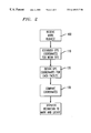
- FIG. 1 shows a block schematic diagram of an apparatus for screening work requests in accordance with the invention.
- FIG. 2 shows a flow chart diagram of the steps associated with screening work requests in accordance with the invention.
- FIG. 3 shows an alternate preferred embodiment of the apparatus of FIG. 1 for screening work requests in accordance with the invention.
- a contractor seeking to perform work e.g., excavation
- a work site 10 that may encompass one or more buried conveyances 12 (only one of which is shown) generally must first submit a work request 14 to a One-Call Center 16 .
- the One-Call center 16 screens each work request 14 to determine whether to notify the various utilities 18 (only one shown) who may maintain buried conveyances, such as buried conveyance 12 , in the region 10 where work is to occur.
- Each work request 14 contains location information 20 specifying site where the where the work will occur.
- the One-Call Center 16 examined the location information 20 to determine whether a utility, such as utility 18 , had one or more buried conveyances within the boundary of the work site whose location is specified by the location information 20 . If the One-Call Center 16 determined from its records that the utility 18 had a conveyance, such as conveyance 12 , within the boundary of the work site, the One-Call center passed the work request 14 to the utility. In response, the utility would dispatch personnel to the work site to physically locate and mark the conveyance 12 depending on the utility's policy required separation distance between the conveyance and the work site boundary.
- a utility such as utility 18
- GPS Global Positioning Satellite
- the utility 18 maintains at least one processor 22 , in the form of a personal computer or the like into which the data contained in each work request 14 is entered following receipt of the work request from the One-Call Center 16 .
- the processor 22 establishes the GPS coordinates of the site where the work will occur.
- the work request 14 will include a data block 24 containing the work site GPS coordinates, in which case, the processor simply establishes the GPS work site coordinates from the data block 24 on the work request 14 .
- the work request 14 may not include the GPS coordinates of the work site location.
- the data block 24 may be devoid of any data.
- the processor 22 queries a database 26 that maps locations to a corresponding set of GPS coordinates. In this way, the processor 22 can establish the GPS coordinates for a work site though the associated work request contains no such coordinates.
- the processor 22 also has access to a database 28 that stores the GPS coordinates for the buried conveyances maintained by the utility.
- a technique for capturing the GPS coordinates during installation of a buried conveyance, such as an optical fiber, is described and claimed in U.S. patent application Ser. No. 09/089,827, filed on Jun. 3, 1998, in the name of Hossein Eslambolchi and John S. Huffman, and assigned to AT&T (incorporated by reference herein).
- the GPS location coordinates captured in accordance with the teachings of the '827 application can be supplied to the database 28 in a variety of ways, such as by direct electronic transfer of data, or via a magnetic or optical medium.
- the processor 22 can compare the GPS coordinates of each of its buried conveyances, such as conveyance 12 , to the GPS coordinates established for the work site and determine whether the work site is within a minimum distance as to require dispatching technicians to physically locate and mark the conveyance.
- FIG. 2 depicts in flow chart form the steps executed by the processor 22 of FIG. 1 to screen each work request 14 of FIG. 1 .
- the processor 22 receives the work request 14 (step 100 ) and thereafter establishes the GPS coordinates for the work site (step 110 ).
- the processor 22 establishes the GPS work site coordinates simply reading them from the work request 14 if the coordinates are present in the data block 24 of FIG. 1 . Otherwise, the processor 22 must query the database 26 to map the work site location to a corresponding set of GPS coordinates.
- the processor 22 After the processor 22 establishes the GPS coordinates for the work site, then the processor obtains the GPS coordinates for each buried conveyance, such as conveyance 12 by querying the database 28 (step 120 ).
- the database 28 contains the GPS coordinates of buried conveyances maintained by the utility 18 .
- the utility would store the GPS coordinates of such facilities in the database 28 .
- the processor 22 makes a comparison between the GPS work site coordinates and the GPS facility coordinates (step 130 ) to determine whether any facility, such as buried conveyance 12 , lies within a minimum distance from the work site. If a facility lies within the minimum distance, then a technician is dispatched to physically locate and mark the conveyance (step 140 ). Typically, such locating is accomplished by electromagnetic signaling. If no facility lies within the work site, then the processor so advises the One-call center 16 .
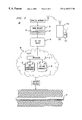
- FIG. 3 shows an alternate preferred embodiment 100 of the apparatus for screening work requests in accordance with the invention.
- the apparatus 100 of FIG. 3 includes many of the same elements as the apparatus of FIG. 1 and like reference numbers are used to describe like elements.
- the apparatus of FIG. 3 includes a combined wireless telephone/GPS receiver 110 for use by a contractor in making the work request 14 to the one-call center 16 .
- the combined wireless telephone/GPS receiver 110 includes a GPS receiver portion 112 that operates to receive GPS satellite information to establish the GPS coordinates of its location similar to-a conventional GPS receiver.
- the GPS receiver portion 112 provides the GPS location information to a wireless transceiver portion 114 for broadcast thereby to a wireless network 116 which carries the call made by the combined wireless telephone/GPS receiver 110 to the one call center 16 .
- the advantage achieved by having a contractor utilize the combined wireless telephone/GPS receiver 110 to communicate the work request 14 to the one-call center 16 is that the combined wireless telephone/GPS receiver automatically provides the GPS coordinates 24 . Otherwise, the contractor would need to make the measurement separately, or simply omit this information, requiring that the utility 18 establish the coordinates in the manner described with respect to FIG. 1 . Having the contractor use the combined wireless telephone/GPS receiver 110 to communicate the work request 14 , and thus automatically provide the GPS coordinates 24 will greatly simply improve the accuracy of the screening process.
- the foregoing describes a technique for screening work requests by comparing the GPS coordinates of the work site to the GPS coordinate of each of a set of facilities to determine if any facility lies within a minimum distance from the work site to warrant physical location and marking of the facility
Abstract
An entity (18) that maintains facilities, such as buried conveyances (12) screens requests by contractors to undertake work that may potentially impact such facilities by comparing the Global Satellite Positioning (GPS) coordinates associated with the location of the work to the GPS coordinates of each facility. In the event that the work will occur within a minimum separation distance from the facility, then the entity maintaining the facility will dispatch a technician to physically locate and mark the facility.
Description
This application is a continuation-in-part of U.S. application Ser. No. 09/239,931 filed Jan. 29, 1999, now abandoned.
This invention relates to a technique for enabling an entity to screen a request for work to determine whether work will occur at a site is sufficiently close in proximity to the location of one of the entity's facilities such that the work may damage the facility.
Most utilities, such as those that provide electric, water, gas or telephone service, bury their conveyances (i.e., pipes and cables) underground both for reasons of safety and esthetics. For example, AT&T as a provider of telecommunications services, maintains a network of some 50,000 miles of buried optical fiber cable installed in a variety of environments. AT&T's network of buried optical fiber runs under city streets, rural farmland, and along other public and private rights of way. Although burial does protect such optical fiber cables from the elements, such buried cables, as well as other underground conveyances, do remain vulnerable to damage from excavation by contractors.
In many areas, governmental regulations require that contractors seeking to excavate first contact a central agency, often referred to as a “One-Call Center,” prior to undertaking excavation. Personnel at the center forward such contractor work requests to those entities that maintain buried cables within the region served by the center. Each entity screens the work request to determine whether the work anticipated by the contractor will actually occur sufficiently close to that entity's underground conveyances to require dispatching personnel to physically locate and mark such buried conveyances. Each year, One-Call Centers in the United States process numerous requests, so an entity that maintains buried conveyances must devote significant personnel and resources to perform the location and marking of buried conveyances.
Some One-Call Centers do a better job of screening work requests than others. For example, some centers will report work requests with out regard to boundaries, while others will screen works requests within boundaries, thus avoiding sending such requests to entities that lack buried conveyances within the specified boundary. However, even screening of work requests based on a specified boundary has its limits. Often the boundary specified in the work request may lack sufficient accuracy for an entity that maintains buried conveyances to rely on a general comparison between the specified boundary data and the entity's own conveyance location records for screening purposes. For this reason, most entities that maintain buried conveyances, such as AT&T, often take a “better safe than sorry” attitude and usually dispatch technicians to mark and locate, even though making and locating may not have been necessary.
Thus, there is a need for a technique for more accurately screening work requests.
Briefly, the present invention provides a method for use by an entity, such as a utility or the like, that maintains facilities, such as buried conveyances, to screen work requests such as from contractors seeking to perform work in close proximity to a facility to determine whether the work may cause damage to such facility. In accordance with the invention, the entity first receives a work request that identifies the site at which the work will occur. Thereafter, the entity receiving the work request establishes the Global Positioning Satellite (GPS) coordinates corresponding to site where the work will occur. In some instances, the work request will include the GPS coordinates of the work site so the entity receiving the work request need only read the GPS coordinates from the request. For example, a contractor may make the work request with the aid of a special wireless telephone that includes an integral GPS receiver that automatically provides the GPS coordinates to the screening entity. When the GPS coordinates are not present in the work request, the entity will establish the GPS coordinates, either from a map, or a database that such coordinates for different locations. Once the GPS coordinates corresponding to the work site are established, then the GPS work site coordinates are compared to the GPS coordinates of each facility to determine whether the work site is sufficiently close to a facility to warrant concern.
FIG. 1 shows a block schematic diagram of an apparatus for screening work requests in accordance with the invention; and
FIG. 2 shows a flow chart diagram of the steps associated with screening work requests in accordance with the invention.
FIG. 3 shows an alternate preferred embodiment of the apparatus of FIG. 1 for screening work requests in accordance with the invention.
Referring to FIG. 1, a contractor seeking to perform work (e.g., excavation) at a work site 10 that may encompass one or more buried conveyances 12 (only one of which is shown) generally must first submit a work request 14 to a One-Call Center 16. The One-Call center 16 screens each work request 14 to determine whether to notify the various utilities 18 (only one shown) who may maintain buried conveyances, such as buried conveyance 12, in the region 10 where work is to occur.
Each work request 14 contains location information 20 specifying site where the where the work will occur. Traditionally, the One-Call Center 16 examined the location information 20 to determine whether a utility, such as utility 18, had one or more buried conveyances within the boundary of the work site whose location is specified by the location information 20. If the One-Call Center 16 determined from its records that the utility 18 had a conveyance, such as conveyance 12, within the boundary of the work site, the One-Call center passed the work request 14 to the utility. In response, the utility would dispatch personnel to the work site to physically locate and mark the conveyance 12 depending on the utility's policy required separation distance between the conveyance and the work site boundary.
Unfortunately, not all One-Call Centers provide good location-boundary screening of the type described above. Some centers simply pass all work requests directly to each utility, forcing the each utility to perform its own screening. Such screening is time consuming, and increases operating costs.
In accordance with the invention, a utility, such as utility 18, can achieve more accurate screening of work requests by comparing the corresponding Global Positioning Satellite (GPS) coordinates for the work site against the GPS coordinates of the buried conveyances maintained by the utility. To accomplish such screening, the utility 18 maintains at least one processor 22, in the form of a personal computer or the like into which the data contained in each work request 14 is entered following receipt of the work request from the One-Call Center 16. For each received work request 14, the processor 22 establishes the GPS coordinates of the site where the work will occur. In some instances, the work request 14 will include a data block 24 containing the work site GPS coordinates, in which case, the processor simply establishes the GPS work site coordinates from the data block 24 on the work request 14. However, the work request 14 may not include the GPS coordinates of the work site location. In other words, the data block 24 may be devoid of any data. Under such circumstances, the processor 22 queries a database 26 that maps locations to a corresponding set of GPS coordinates. In this way, the processor 22 can establish the GPS coordinates for a work site though the associated work request contains no such coordinates.
In addition to the database 26, the processor 22 also has access to a database 28 that stores the GPS coordinates for the buried conveyances maintained by the utility. A technique for capturing the GPS coordinates during installation of a buried conveyance, such as an optical fiber, is described and claimed in U.S. patent application Ser. No. 09/089,827, filed on Jun. 3, 1998, in the name of Hossein Eslambolchi and John S. Huffman, and assigned to AT&T (incorporated by reference herein). The GPS location coordinates captured in accordance with the teachings of the '827 application can be supplied to the database 28 in a variety of ways, such as by direct electronic transfer of data, or via a magnetic or optical medium. By querying the database 28, the processor 22 can compare the GPS coordinates of each of its buried conveyances, such as conveyance 12, to the GPS coordinates established for the work site and determine whether the work site is within a minimum distance as to require dispatching technicians to physically locate and mark the conveyance.
FIG. 2 depicts in flow chart form the steps executed by the processor 22 of FIG. 1 to screen each work request 14 of FIG. 1. Initially, the processor 22 receives the work request 14 (step 100) and thereafter establishes the GPS coordinates for the work site (step 110). As described above, the processor 22 establishes the GPS work site coordinates simply reading them from the work request 14 if the coordinates are present in the data block 24 of FIG. 1. Otherwise, the processor 22 must query the database 26 to map the work site location to a corresponding set of GPS coordinates.
After the processor 22 establishes the GPS coordinates for the work site, then the processor obtains the GPS coordinates for each buried conveyance, such as conveyance 12 by querying the database 28 (step 120). Typically, the database 28 contains the GPS coordinates of buried conveyances maintained by the utility 18. However, to the extent that work requests could impact facilities of the utility 18 other than buried conveyances, the utility would store the GPS coordinates of such facilities in the database 28.
Once the processor 22 has obtained the GPS coordinates for its facilities, then the processor makes a comparison between the GPS work site coordinates and the GPS facility coordinates (step 130) to determine whether any facility, such as buried conveyance 12, lies within a minimum distance from the work site. If a facility lies within the minimum distance, then a technician is dispatched to physically locate and mark the conveyance (step 140). Typically, such locating is accomplished by electromagnetic signaling. If no facility lies within the work site, then the processor so advises the One-call center 16.
FIG. 3 shows an alternate preferred embodiment 100 of the apparatus for screening work requests in accordance with the invention. The apparatus 100 of FIG. 3 includes many of the same elements as the apparatus of FIG. 1 and like reference numbers are used to describe like elements. The apparatus of FIG. 3 includes a combined wireless telephone/GPS receiver 110 for use by a contractor in making the work request 14 to the one-call center 16. The combined wireless telephone/GPS receiver 110 includes a GPS receiver portion 112 that operates to receive GPS satellite information to establish the GPS coordinates of its location similar to-a conventional GPS receiver. The GPS receiver portion 112 provides the GPS location information to a wireless transceiver portion 114 for broadcast thereby to a wireless network 116 which carries the call made by the combined wireless telephone/GPS receiver 110 to the one call center 16.
The advantage achieved by having a contractor utilize the combined wireless telephone/GPS receiver 110 to communicate the work request 14 to the one-call center 16 is that the combined wireless telephone/GPS receiver automatically provides the GPS coordinates 24. Otherwise, the contractor would need to make the measurement separately, or simply omit this information, requiring that the utility 18 establish the coordinates in the manner described with respect to FIG. 1. Having the contractor use the combined wireless telephone/GPS receiver 110 to communicate the work request 14, and thus automatically provide the GPS coordinates 24 will greatly simply improve the accuracy of the screening process.
The foregoing describes a technique for screening work requests by comparing the GPS coordinates of the work site to the GPS coordinate of each of a set of facilities to determine if any facility lies within a minimum distance from the work site to warrant physical location and marking of the facility
The above-described embodiments merely illustrate the principles of the invention. Those skilled in the art may make various modifications and changes that will embody the principles of the invention and fall within the spirit and scope thereof.
Claims (11)
1. A method for use by a party that maintains various facilities at different locations to screen a request for work to occur at a geographic site to determine whether said site is sufficiently close in proximity to the location of one of said various facilities such that said work may damage said one facility, comprising the steps of:
receiving said work request identifying what work is to occur and said geographic site where such work is to occur;
establishing for said received work request a set of Global Positioning Satellite (GPS) coordinates that identify the geographic site where said work is to occur;
querying a first database containing facility records that each contain a set of GPS coordinates that identify the location of each said facility; and
comparing the GPS coordinates established for said work request to the GPS coordinates for each facility to determine whether any of said facilities is sufficiently close in proximity such that work to occur may damage said any facility.
2. The method according to claim 1 wherein the method includes the steps of:
dispatching personnel to said any facility that is sufficient close in proximity to said work; and
physically locating and marking said any facility.
3. The method according to claim 2 wherein said facilities comprise buried conveyances and wherein said any facility is physically located by electromagnetic signaling.
4. The method according to claim 1 wherein the step of establishing the set of GPS coordinates for each work request includes the steps of:
determining whether said work request specifies a set of GPS coordinates for said geographic site where such work is to occur, and, if no such coordinates are specified, then
identifying, from the location of the geographic site where said work is to occur, the GPS coordinates corresponding to said geographic site.
5. The method according to claim 4 wherein the identifying step includes the step of:
querying a second database containing GPS coordinates for potential work sites to establish the GPS coordinates for said geographic site.
6. The method according to claim 1 wherein said work request contains GPS coordinates for said geographic site where said work will occur and wherein the establishing step includes the step of obtaining said GPS coordinates from said work request.
7. The method according to claim 1 further including the step of providing an indication when no facility lies within a predetermined distance from the work site.
8. The method according to claim 1 wherein the step of establishing the Global Positioning Satellite coordinates includes the steps of:
determining the Global Positioning Satellite coordinates via a combined wireless telephone and Global Positioning Satellite receiver;
automatically communicating the Global Positioning Satellite coordinates along with the work request via a wireless communication.
9. A method for use by a party that maintains various facilities at different locations to screen a request for work to occur at a geographic site to determine whether said site is sufficiently close in proximity to the location of one of said various facilities such that said work may damage said one facility, comprising the steps of:
receiving via a wireless communication said work request identifying what work is to occur and said geographic site where such work is to occur along with a set of Global Positioning Satellite (GPS) coordinates that identify the geographic site where said work is to occur;
querying a first database containing facility records that each contain a set of GPS coordinates that identify the location of each said facility; and
comparing the GPS coordinates associated with said work request to the GPS coordinates for each facility to determine whether any of said facilities is sufficiently close in proximity such that work to occur may damage said any facility.
10. The method according to claim 9 wherein the method includes the steps of:
dispatching personnel to said any facility that is sufficient close in proximity to said work; and
physically locating and marking said any facility.
11. The method according to claim 10 wherein said facilities comprise buried conveyances and wherein said any facility is physically located by electromagnetic signaling.
Priority Applications (2)
| Application Number | Priority Date | Filing Date | Title |
|---|---|---|---|
| US09/288,367 US6169517B1 (en) | 1999-01-29 | 1999-04-08 | Technique for screening work requests |
| CA002292019A CA2292019A1 (en) | 1999-01-29 | 1999-12-09 | Technique for screening work requests |
Applications Claiming Priority (2)
| Application Number | Priority Date | Filing Date | Title |
|---|---|---|---|
| US23993199A | 1999-01-29 | 1999-01-29 | |
| US09/288,367 US6169517B1 (en) | 1999-01-29 | 1999-04-08 | Technique for screening work requests |
Related Parent Applications (1)
| Application Number | Title | Priority Date | Filing Date |
|---|---|---|---|
| US23993199A Continuation-In-Part | 1999-01-29 | 1999-01-29 |
Publications (1)
| Publication Number | Publication Date |
|---|---|
| US6169517B1 true US6169517B1 (en) | 2001-01-02 |
Family
ID=31890951
Family Applications (1)
| Application Number | Title | Priority Date | Filing Date |
|---|---|---|---|
| US09/288,367 Expired - Lifetime US6169517B1 (en) | 1999-01-29 | 1999-04-08 | Technique for screening work requests |
Country Status (2)
| Country | Link |
|---|---|
| US (1) | US6169517B1 (en) |
| CA (1) | CA2292019A1 (en) |
Cited By (28)
| Publication number | Priority date | Publication date | Assignee | Title |
|---|---|---|---|---|
| EP1229345A2 (en) * | 2001-01-23 | 2002-08-07 | Ruhrgas Aktiengesellschaft | System for determining the position of construction vehicles or earth moving equipment |
| US20040111313A1 (en) * | 2002-10-29 | 2004-06-10 | Ingman Robert Mitchell | Methods and systems for assigning multiple tasks |
| US20040111312A1 (en) * | 2002-06-19 | 2004-06-10 | Ingman Robert M. | Validating turfs for work orders |
| US20040111311A1 (en) * | 2002-05-31 | 2004-06-10 | Ingman Robert Mitchell | Turfs and skills for multiple technicians |
| US20070106784A1 (en) * | 2005-11-08 | 2007-05-10 | Dickman David T | Systems, methods and apparatus to identify network maintenance zones |
| US20080180322A1 (en) * | 2007-01-26 | 2008-07-31 | Mohammad Mojahedul Islam | Method and system for wireless tracking of utility assets |
| US20090204466A1 (en) * | 2008-02-12 | 2009-08-13 | Nielsen Steven E | Ticket approval system for and method of performing quality control in field service applications |
| US20090201178A1 (en) * | 2007-03-13 | 2009-08-13 | Nielsen Steven E | Methods for evaluating operation of marking apparatus |
| US20090238417A1 (en) * | 2008-03-18 | 2009-09-24 | Nielsen Steven E | Virtual white lines for indicating planned excavation sites on electronic images |
| US20090241045A1 (en) * | 2008-03-18 | 2009-09-24 | Certusview Technologies, Llc | Virtual white lines for delimiting planned excavation sites |
| US20090327024A1 (en) * | 2008-06-27 | 2009-12-31 | Certusview Technologies, Llc | Methods and apparatus for quality assessment of a field service operation |
| US20100085701A1 (en) * | 2008-10-02 | 2010-04-08 | Certusview Technologies, Llc | Marking device docking stations having security features and methods of using same |
| US20100088134A1 (en) * | 2008-10-02 | 2010-04-08 | Certusview Technologies, Llc | Methods and apparatus for analyzing locate and marking operations with respect to historical information |
| US20100201690A1 (en) * | 2009-02-11 | 2010-08-12 | Certusview Technologies, Llc | Virtual white lines (vwl) application for indicating a planned excavation or locate path |
| US20100205555A1 (en) * | 2009-02-11 | 2010-08-12 | Certusview Technologies, Llc | Virtual white lines (vwl) for delimiting planned excavation sites of staged excavation projects |
| US20100205031A1 (en) * | 2009-02-10 | 2010-08-12 | Certusview Technologies, Llc | Methods, apparatus, and systems for exchanging information between excavators and other entities associated with underground facility locate and marking operations |
| US20100228588A1 (en) * | 2009-02-11 | 2010-09-09 | Certusview Technologies, Llc | Management system, and associated methods and apparatus, for providing improved visibility, quality control and audit capability for underground facility locate and/or marking operations |
| US20110022433A1 (en) * | 2009-06-25 | 2011-01-27 | Certusview Technologies, Llc | Methods and apparatus for assessing locate request tickets |
| US20110035324A1 (en) * | 2009-02-11 | 2011-02-10 | CertusView Technologies, LLC. | Methods, apparatus, and systems for generating technician workflows for locate and/or marking operations |
| US20110046999A1 (en) * | 2008-10-02 | 2011-02-24 | Certusview Technologies, Llc | Methods and apparatus for analyzing locate and marking operations by comparing locate information and marking information |
| US20110131081A1 (en) * | 2009-02-10 | 2011-06-02 | Certusview Technologies, Llc | Methods, apparatus, and systems for providing an enhanced positive response in underground facility locate and marking operations |
| US20120036140A1 (en) * | 2010-08-05 | 2012-02-09 | Certusview Technologies, Llc | Methods and apparatus for analyzing locate and marking operations by comparing filtered locate and/or marking information |
| US8612276B1 (en) | 2009-02-11 | 2013-12-17 | Certusview Technologies, Llc | Methods, apparatus, and systems for dispatching service technicians |
| US8949397B2 (en) | 2009-10-14 | 2015-02-03 | Blackberry Limited | Maintenance methods, devices and systems for mobile communications system |
| US8990100B2 (en) | 2008-10-02 | 2015-03-24 | Certusview Technologies, Llc | Methods and apparatus for analyzing locate and marking operations with respect to environmental landmarks |
| US9208458B2 (en) | 2008-10-02 | 2015-12-08 | Certusview Technologies, Llc | Methods and apparatus for analyzing locate and marking operations with respect to facilities maps |
| US9473626B2 (en) | 2008-06-27 | 2016-10-18 | Certusview Technologies, Llc | Apparatus and methods for evaluating a quality of a locate operation for underground utility |
| CN111238453A (en) * | 2018-11-28 | 2020-06-05 | 赫克斯冈技术中心 | Intelligent positioning module |
-
1999
- 1999-04-08 US US09/288,367 patent/US6169517B1/en not_active Expired - Lifetime
- 1999-12-09 CA CA002292019A patent/CA2292019A1/en not_active Abandoned
Cited By (106)
| Publication number | Priority date | Publication date | Assignee | Title |
|---|---|---|---|---|
| EP1229345A3 (en) * | 2001-01-23 | 2003-12-03 | Ruhrgas Aktiengesellschaft | System for Determining the Position of Construction Vehicles or Earth Moving Equipment |
| EP1229345A2 (en) * | 2001-01-23 | 2002-08-07 | Ruhrgas Aktiengesellschaft | System for determining the position of construction vehicles or earth moving equipment |
| US20040111311A1 (en) * | 2002-05-31 | 2004-06-10 | Ingman Robert Mitchell | Turfs and skills for multiple technicians |
| US7451098B2 (en) | 2002-05-31 | 2008-11-11 | At&T Intellectual Property I, L.P. | Method, system, and computer program product for assigning multiple telecommunications technicians at one time to at least one skill and a turf |
| US20040111312A1 (en) * | 2002-06-19 | 2004-06-10 | Ingman Robert M. | Validating turfs for work orders |
| US7433830B2 (en) * | 2002-06-19 | 2008-10-07 | At&T Intellectual Property I, L.P. | Method and system for assigning and dispatching a telecommunications systems work order based on global positioning information |
| US7840434B2 (en) | 2002-10-29 | 2010-11-23 | At&T Intellectual Property I, L. P. | Methods and systems for assigning multiple tasks |
| US20040111313A1 (en) * | 2002-10-29 | 2004-06-10 | Ingman Robert Mitchell | Methods and systems for assigning multiple tasks |
| US20070106784A1 (en) * | 2005-11-08 | 2007-05-10 | Dickman David T | Systems, methods and apparatus to identify network maintenance zones |
| US20080180322A1 (en) * | 2007-01-26 | 2008-07-31 | Mohammad Mojahedul Islam | Method and system for wireless tracking of utility assets |
| US20090201178A1 (en) * | 2007-03-13 | 2009-08-13 | Nielsen Steven E | Methods for evaluating operation of marking apparatus |
| US8401791B2 (en) | 2007-03-13 | 2013-03-19 | Certusview Technologies, Llc | Methods for evaluating operation of marking apparatus |
| US20090210298A1 (en) * | 2008-02-12 | 2009-08-20 | Certusview Technologies, Llc | Ticket approval system for and method of performing quality control in field service applications |
| US20090207019A1 (en) * | 2008-02-12 | 2009-08-20 | Certusview Technologies, Llc | Ticket approval system for and method of performing quality control in field service applications |
| US20090210284A1 (en) * | 2008-02-12 | 2009-08-20 | Certusview Technologies, Llc | Ticket approval system for and method of performing quality control in field service applications |
| US20090210297A1 (en) * | 2008-02-12 | 2009-08-20 | Certusview Technologies, Llc | Ticket approval system for and method of performing quality control in field service applications |
| US8194932B2 (en) | 2008-02-12 | 2012-06-05 | Certusview Technologies, Llc | Ticket approval system for and method of performing quality control in field service applications |
| US9659268B2 (en) | 2008-02-12 | 2017-05-23 | CertusVies Technologies, LLC | Ticket approval system for and method of performing quality control in field service applications |
| US8478635B2 (en) | 2008-02-12 | 2013-07-02 | Certusview Technologies, Llc | Ticket approval methods of performing quality control in underground facility locate and marking operations |
| US20090204466A1 (en) * | 2008-02-12 | 2009-08-13 | Nielsen Steven E | Ticket approval system for and method of performing quality control in field service applications |
| US8861794B2 (en) | 2008-03-18 | 2014-10-14 | Certusview Technologies, Llc | Virtual white lines for indicating planned excavation sites on electronic images |
| US8861795B2 (en) | 2008-03-18 | 2014-10-14 | Certusview Technologies, Llc | Virtual white lines for delimiting planned excavation sites |
| US20110135163A1 (en) * | 2008-03-18 | 2011-06-09 | Certusview Technologies, Llc | Methods and apparatus for providing unbuffered dig area indicators on aerial images to delimit planned excavation sites |
| US8155390B2 (en) | 2008-03-18 | 2012-04-10 | Certusview Technologies, Llc | Methods and apparatus for providing unbuffered dig area indicators on aerial images to delimit planned excavation sites |
| US20090238417A1 (en) * | 2008-03-18 | 2009-09-24 | Nielsen Steven E | Virtual white lines for indicating planned excavation sites on electronic images |
| US8218827B2 (en) | 2008-03-18 | 2012-07-10 | Certusview Technologies, Llc | Virtual white lines for delimiting planned excavation sites |
| US8249306B2 (en) | 2008-03-18 | 2012-08-21 | Certusview Technologies, Llc | Virtual white lines for delimiting planned excavation sites |
| US8280117B2 (en) | 2008-03-18 | 2012-10-02 | Certusview Technologies, Llc | Virtual white lines for indicating planned excavation sites on electronic images |
| US9830338B2 (en) | 2008-03-18 | 2017-11-28 | Certusview Technologies, Inc. | Virtual white lines for indicating planned excavation sites on electronic images |
| US20090238414A1 (en) * | 2008-03-18 | 2009-09-24 | Dycom Technology, Llc | Virtual white lines for delimiting planned excavation sites |
| US8290215B2 (en) | 2008-03-18 | 2012-10-16 | Certusview Technologies, Llc | Virtual white lines for delimiting planned excavation sites |
| US8300895B2 (en) | 2008-03-18 | 2012-10-30 | Certusview Technologies, Llc | Virtual white lines for delimiting planned excavation sites |
| US8355542B2 (en) | 2008-03-18 | 2013-01-15 | Certusview Technologies, Llc | Virtual white lines for delimiting planned excavation sites |
| US20090241045A1 (en) * | 2008-03-18 | 2009-09-24 | Certusview Technologies, Llc | Virtual white lines for delimiting planned excavation sites |
| US8934678B2 (en) | 2008-03-18 | 2015-01-13 | Certusview Technologies, Llc | Virtual white lines for delimiting planned excavation sites |
| US20090238416A1 (en) * | 2008-03-18 | 2009-09-24 | Steven Nielsen | Virtual white lines for delimiting planned excavation sites |
| US20090237408A1 (en) * | 2008-03-18 | 2009-09-24 | Nielsen Steven E | Virtual white lines for delimiting planned excavation sites |
| US20090241046A1 (en) * | 2008-03-18 | 2009-09-24 | Steven Nielsen | Virtual white lines for delimiting planned excavation sites |
| US20090238415A1 (en) * | 2008-03-18 | 2009-09-24 | Certusview Technologies, Llc | Virtual white lines for delimiting planned excavation sites |
| US9256849B2 (en) | 2008-06-27 | 2016-02-09 | Certusview Technologies, Llc | Apparatus and methods for evaluating a quality of a locate operation for underground utility |
| US9317830B2 (en) | 2008-06-27 | 2016-04-19 | Certusview Technologies, Llc | Methods and apparatus for analyzing locate and marking operations |
| US9473626B2 (en) | 2008-06-27 | 2016-10-18 | Certusview Technologies, Llc | Apparatus and methods for evaluating a quality of a locate operation for underground utility |
| US9578678B2 (en) | 2008-06-27 | 2017-02-21 | Certusview Technologies, Llc | Methods and apparatus for facilitating locate and marking operations |
| US9916588B2 (en) | 2008-06-27 | 2018-03-13 | Certusview Technologies, Llc | Methods and apparatus for quality assessment of a field service operation based on dynamic assessment parameters |
| US20100010882A1 (en) * | 2008-06-27 | 2010-01-14 | Certusview Technologies, Llc | Methods and apparatus for quality assessment of a field service operation based on dynamic assessment parameters |
| US20100010862A1 (en) * | 2008-06-27 | 2010-01-14 | Certusview Technologies, Llc | Methods and apparatus for quality assessment of a field service operation based on geographic information |
| US20100010883A1 (en) * | 2008-06-27 | 2010-01-14 | Certusview Technologies, Llc | Methods and apparatus for facilitating a quality assessment of a field service operation based on multiple quality assessment criteria |
| US20100010863A1 (en) * | 2008-06-27 | 2010-01-14 | Certusview Technologies, Llc | Methods and apparatus for quality assessment of a field service operation based on multiple scoring categories |
| US20090327024A1 (en) * | 2008-06-27 | 2009-12-31 | Certusview Technologies, Llc | Methods and apparatus for quality assessment of a field service operation |
| US20110046999A1 (en) * | 2008-10-02 | 2011-02-24 | Certusview Technologies, Llc | Methods and apparatus for analyzing locate and marking operations by comparing locate information and marking information |
| US9208458B2 (en) | 2008-10-02 | 2015-12-08 | Certusview Technologies, Llc | Methods and apparatus for analyzing locate and marking operations with respect to facilities maps |
| US20100085701A1 (en) * | 2008-10-02 | 2010-04-08 | Certusview Technologies, Llc | Marking device docking stations having security features and methods of using same |
| US8620726B2 (en) | 2008-10-02 | 2013-12-31 | Certusview Technologies, Llc | Methods and apparatus for analyzing locate and marking operations by comparing locate information and marking information |
| US20100088134A1 (en) * | 2008-10-02 | 2010-04-08 | Certusview Technologies, Llc | Methods and apparatus for analyzing locate and marking operations with respect to historical information |
| US8644965B2 (en) | 2008-10-02 | 2014-02-04 | Certusview Technologies, Llc | Marking device docking stations having security features and methods of using same |
| US8990100B2 (en) | 2008-10-02 | 2015-03-24 | Certusview Technologies, Llc | Methods and apparatus for analyzing locate and marking operations with respect to environmental landmarks |
| US9208464B2 (en) | 2008-10-02 | 2015-12-08 | Certusview Technologies, Llc | Methods and apparatus for analyzing locate and marking operations with respect to historical information |
| US9646353B2 (en) | 2009-02-10 | 2017-05-09 | Certusview Technologies, Llc | Methods, apparatus, and systems for exchanging information between excavators and other entities associated with underground facility locate and marking operations |
| US20100259381A1 (en) * | 2009-02-10 | 2010-10-14 | Certusview Technologies, Llc | Methods, apparatus and systems for notifying excavators and other entities of the status of in-progress underground facility locate and marking operations |
| US20100205031A1 (en) * | 2009-02-10 | 2010-08-12 | Certusview Technologies, Llc | Methods, apparatus, and systems for exchanging information between excavators and other entities associated with underground facility locate and marking operations |
| US8280969B2 (en) | 2009-02-10 | 2012-10-02 | Certusview Technologies, Llc | Methods, apparatus and systems for requesting underground facility locate and marking operations and managing associated notifications |
| US9177280B2 (en) | 2009-02-10 | 2015-11-03 | Certusview Technologies, Llc | Methods, apparatus, and systems for acquiring an enhanced positive response for underground facility locate and marking operations based on an electronic manifest documenting physical locate marks on ground, pavement, or other surface |
| US8572193B2 (en) | 2009-02-10 | 2013-10-29 | Certusview Technologies, Llc | Methods, apparatus, and systems for providing an enhanced positive response in underground facility locate and marking operations |
| US20100205264A1 (en) * | 2009-02-10 | 2010-08-12 | Certusview Technologies, Llc | Methods, apparatus, and systems for exchanging information between excavators and other entities associated with underground facility locate and marking operations |
| US9235821B2 (en) | 2009-02-10 | 2016-01-12 | Certusview Technologies, Llc | Methods, apparatus, and systems for providing an enhanced positive response for underground facility locate and marking operations based on an electronic manifest documenting physical locate marks on ground, pavement or other surface |
| US9773217B2 (en) | 2009-02-10 | 2017-09-26 | Certusview Technologies, Llc | Methods, apparatus, and systems for acquiring an enhanced positive response for underground facility locate and marking operations |
| US20110131081A1 (en) * | 2009-02-10 | 2011-06-02 | Certusview Technologies, Llc | Methods, apparatus, and systems for providing an enhanced positive response in underground facility locate and marking operations |
| US20100268786A1 (en) * | 2009-02-10 | 2010-10-21 | Certusview Technologies, Llc | Methods, apparatus and systems for requesting underground facility locate and marking operations and managing associated notifications |
| US8468206B2 (en) | 2009-02-10 | 2013-06-18 | Certusview Technologies, Llc | Methods, apparatus and systems for notifying excavators and other entities of the status of in-progress underground facility locate and marking operations |
| US20100259414A1 (en) * | 2009-02-10 | 2010-10-14 | Certusview Technologies, Llc | Methods, apparatus and systems for submitting virtual white line drawings and managing notifications in connection with underground facility locate and marking operations |
| US8484300B2 (en) | 2009-02-10 | 2013-07-09 | Certusview Technologies, Llc | Methods, apparatus and systems for communicating information relating to the performance of underground facility locate and marking operations to excavators and other entities |
| US8543651B2 (en) | 2009-02-10 | 2013-09-24 | Certusview Technologies, Llc | Methods, apparatus and systems for submitting virtual white line drawings and managing notifications in connection with underground facility locate and marking operations |
| US8549084B2 (en) | 2009-02-10 | 2013-10-01 | Certusview Technologies, Llc | Methods, apparatus, and systems for exchanging information between excavators and other entities associated with underground facility locate and marking operations |
| US8356255B2 (en) | 2009-02-11 | 2013-01-15 | Certusview Technologies, Llc | Virtual white lines (VWL) for delimiting planned excavation sites of staged excavation projects |
| US20110035260A1 (en) * | 2009-02-11 | 2011-02-10 | Certusview Technologies, Llc | Methods, apparatus, and systems for quality assessment of locate and/or marking operations based on process guides |
| US8612276B1 (en) | 2009-02-11 | 2013-12-17 | Certusview Technologies, Llc | Methods, apparatus, and systems for dispatching service technicians |
| US8384742B2 (en) | 2009-02-11 | 2013-02-26 | Certusview Technologies, Llc | Virtual white lines (VWL) for delimiting planned excavation sites of staged excavation projects |
| US8626571B2 (en) | 2009-02-11 | 2014-01-07 | Certusview Technologies, Llc | Management system, and associated methods and apparatus, for dispatching tickets, receiving field information, and performing a quality assessment for underground facility locate and/or marking operations |
| US20100201690A1 (en) * | 2009-02-11 | 2010-08-12 | Certusview Technologies, Llc | Virtual white lines (vwl) application for indicating a planned excavation or locate path |
| US8731999B2 (en) | 2009-02-11 | 2014-05-20 | Certusview Technologies, Llc | Management system, and associated methods and apparatus, for providing improved visibility, quality control and audit capability for underground facility locate and/or marking operations |
| US20100205555A1 (en) * | 2009-02-11 | 2010-08-12 | Certusview Technologies, Llc | Virtual white lines (vwl) for delimiting planned excavation sites of staged excavation projects |
| US8832565B2 (en) | 2009-02-11 | 2014-09-09 | Certusview Technologies, Llc | Methods and apparatus for controlling access to a virtual white line (VWL) image for an excavation project |
| US20100318401A1 (en) * | 2009-02-11 | 2010-12-16 | Certusview Technologies, Llc | Methods and apparatus for performing locate and/or marking operations with improved visibility, quality control and audit capability |
| US20100228588A1 (en) * | 2009-02-11 | 2010-09-09 | Certusview Technologies, Llc | Management system, and associated methods and apparatus, for providing improved visibility, quality control and audit capability for underground facility locate and/or marking operations |
| US9563863B2 (en) | 2009-02-11 | 2017-02-07 | Certusview Technologies, Llc | Marking apparatus equipped with ticket processing software for facilitating marking operations, and associated methods |
| US20100205536A1 (en) * | 2009-02-11 | 2010-08-12 | Certusview Technologies, Llc | Methods and apparatus for controlling access to a virtual white line (vwl) image for an excavation project |
| US8296308B2 (en) | 2009-02-11 | 2012-10-23 | Certusview Technologies, Llc | Methods and apparatus for associating a virtual white line (VWL) image with corresponding ticket information for an excavation project |
| US20110035324A1 (en) * | 2009-02-11 | 2011-02-10 | CertusView Technologies, LLC. | Methods, apparatus, and systems for generating technician workflows for locate and/or marking operations |
| US9185176B2 (en) | 2009-02-11 | 2015-11-10 | Certusview Technologies, Llc | Methods and apparatus for managing locate and/or marking operations |
| US20110035251A1 (en) * | 2009-02-11 | 2011-02-10 | Certusview Technologies, Llc | Methods, apparatus, and systems for facilitating and/or verifying locate and/or marking operations |
| US8566737B2 (en) | 2009-02-11 | 2013-10-22 | Certusview Technologies, Llc | Virtual white lines (VWL) application for indicating an area of planned excavation |
| US20110035245A1 (en) * | 2009-02-11 | 2011-02-10 | Certusview Technologies, Llc | Methods, apparatus, and systems for processing technician workflows for locate and/or marking operations |
| US20110035328A1 (en) * | 2009-02-11 | 2011-02-10 | Certusview Technologies, Llc | Methods, apparatus, and systems for generating technician checklists for locate and/or marking operations |
| US20100201706A1 (en) * | 2009-02-11 | 2010-08-12 | Certusview Technologies, Llc | Virtual white lines (vwl) for delimiting planned excavation sites of staged excavation projects |
| US20110022433A1 (en) * | 2009-06-25 | 2011-01-27 | Certusview Technologies, Llc | Methods and apparatus for assessing locate request tickets |
| US20140236656A1 (en) * | 2009-06-25 | 2014-08-21 | Certusview Technologies, Llc | Methods and apparatus for assessing risks associated with locate request tickets based on historical information |
| US20110040589A1 (en) * | 2009-06-25 | 2011-02-17 | Certusview Technologies, Llc | Methods and apparatus for assessing complexity of locate request tickets |
| US9646275B2 (en) * | 2009-06-25 | 2017-05-09 | Certusview Technologies, Llc | Methods and apparatus for assessing risks associated with locate request tickets based on historical information |
| US20110046994A1 (en) * | 2009-06-25 | 2011-02-24 | Certusview Technologies, Llc | Methods and apparatus for multi-stage assessment of locate request tickets |
| US20110040590A1 (en) * | 2009-06-25 | 2011-02-17 | Certusview Technologies, Llc | Methods and apparatus for improving a ticket assessment system |
| US20110046993A1 (en) * | 2009-06-25 | 2011-02-24 | Certusview Technologies, Llc | Methods and apparatus for assessing risks associated with locate request tickets |
| US8949397B2 (en) | 2009-10-14 | 2015-02-03 | Blackberry Limited | Maintenance methods, devices and systems for mobile communications system |
| US20120036140A1 (en) * | 2010-08-05 | 2012-02-09 | Certusview Technologies, Llc | Methods and apparatus for analyzing locate and marking operations by comparing filtered locate and/or marking information |
| CN111238453A (en) * | 2018-11-28 | 2020-06-05 | 赫克斯冈技术中心 | Intelligent positioning module |
| US11486704B2 (en) | 2018-11-28 | 2022-11-01 | Hexagon Technology Center Gmbh | Intelligent positioning module |
| CN111238453B (en) * | 2018-11-28 | 2023-09-05 | 赫克斯冈技术中心 | Intelligent positioning module |
Also Published As
| Publication number | Publication date |
|---|---|
| CA2292019A1 (en) | 2000-07-29 |
Similar Documents
| Publication | Publication Date | Title |
|---|---|---|
| US6169517B1 (en) | Technique for screening work requests | |
| US6850161B1 (en) | Systems and methods for identifying and mapping conduit location | |
| US9773217B2 (en) | Methods, apparatus, and systems for acquiring an enhanced positive response for underground facility locate and marking operations | |
| US7385516B2 (en) | Location visit confirmation services for wireless devices | |
| US8509412B2 (en) | System and method for providing routing, mapping, and relative position information to users of a communication network | |
| US6349211B2 (en) | Position display system of mobile terminal | |
| US20150379041A1 (en) | Ticket entry systems and methods | |
| US8135540B2 (en) | Methods and systems for determining a telecommunications service location using global satellite positioning | |
| US5625668A (en) | Position reporting cellular telephone | |
| US7292865B2 (en) | Location visit detail services for wireless devices | |
| US20120158901A1 (en) | Ticket and data management | |
| US20060282280A1 (en) | Ticket and data management | |
| US20030032404A1 (en) | Service zone management system & method | |
| US20070038371A1 (en) | Methods and systems for routing travel between origin and destination service locations using global satellite positioning | |
| US20100227625A1 (en) | System and Method for Accessing Computer Services Via a Wireless Network | |
| AU2002320609A1 (en) | Position determination system | |
| US20130325542A1 (en) | System and method for distribution of utility asset data in a project area | |
| US9759833B2 (en) | Buried asset detection including portable transmitter hookup logging | |
| US7120466B2 (en) | Method for accepting sign-up applications from applicants who desire to utilize wireless communication services | |
| JP2002297708A (en) | System for receiving work information | |
| KR20110082237A (en) | An apparatus for work management using mobile phone | |
| US8823492B2 (en) | Detection of incursion of proposed excavation zones into buried assets |
Legal Events
| Date | Code | Title | Description |
|---|---|---|---|
| AS | Assignment |
Owner name: AT&T CORPORATION, NEW YORK Free format text: ASSIGNMENT OF ASSIGNORS INTEREST;ASSIGNORS:ESLAMBOLCHI, HOSSEIN;HUFFMAN, JOHN SINCLAIR;IANNA, FRANK;REEL/FRAME:009894/0199;SIGNING DATES FROM 19990324 TO 19990331 |
|
| STCF | Information on status: patent grant |
Free format text: PATENTED CASE |
|
| FEPP | Fee payment procedure |
Free format text: PAYOR NUMBER ASSIGNED (ORIGINAL EVENT CODE: ASPN); ENTITY STATUS OF PATENT OWNER: LARGE ENTITY |
|
| FPAY | Fee payment |
Year of fee payment: 4 |
|
| FPAY | Fee payment |
Year of fee payment: 8 |
|
| FPAY | Fee payment |
Year of fee payment: 12 |