US9501507B1 - Geo-temporal indexing and searching - Google Patents
Geo-temporal indexing and searching Download PDFInfo
- Publication number
- US9501507B1 US9501507B1 US13/728,879 US201213728879A US9501507B1 US 9501507 B1 US9501507 B1 US 9501507B1 US 201213728879 A US201213728879 A US 201213728879A US 9501507 B1 US9501507 B1 US 9501507B1
- Authority
- US
- United States
- Prior art keywords
- data
- temporal
- time
- component
- index
- Prior art date
- Legal status (The legal status is an assumption and is not a legal conclusion. Google has not performed a legal analysis and makes no representation as to the accuracy of the status listed.)
- Active, expires
Links
- 230000002123 temporal effect Effects 0.000 claims abstract description 118
- 235000019580 granularity Nutrition 0.000 claims abstract description 46
- 238000000034 method Methods 0.000 claims abstract description 38
- 238000001914 filtration Methods 0.000 claims description 5
- 238000007405 data analysis Methods 0.000 abstract 1
- 238000004891 communication Methods 0.000 description 19
- 230000007246 mechanism Effects 0.000 description 18
- 238000012545 processing Methods 0.000 description 13
- 230000000694 effects Effects 0.000 description 10
- 238000013459 approach Methods 0.000 description 6
- 230000008520 organization Effects 0.000 description 6
- 230000005540 biological transmission Effects 0.000 description 5
- 230000003287 optical effect Effects 0.000 description 5
- 230000008569 process Effects 0.000 description 5
- 230000004044 response Effects 0.000 description 5
- 238000010586 diagram Methods 0.000 description 4
- 238000013500 data storage Methods 0.000 description 2
- 238000007726 management method Methods 0.000 description 2
- 230000003068 static effect Effects 0.000 description 2
- RYGMFSIKBFXOCR-UHFFFAOYSA-N Copper Chemical compound [Cu] RYGMFSIKBFXOCR-UHFFFAOYSA-N 0.000 description 1
- 238000004458 analytical method Methods 0.000 description 1
- 238000003491 array Methods 0.000 description 1
- 230000000712 assembly Effects 0.000 description 1
- 238000000429 assembly Methods 0.000 description 1
- 238000013475 authorization Methods 0.000 description 1
- 238000012937 correction Methods 0.000 description 1
- 230000008878 coupling Effects 0.000 description 1
- 238000010168 coupling process Methods 0.000 description 1
- 238000005859 coupling reaction Methods 0.000 description 1
- 238000013144 data compression Methods 0.000 description 1
- 239000000835 fiber Substances 0.000 description 1
- 230000006870 function Effects 0.000 description 1
- 230000008676 import Effects 0.000 description 1
- 230000006855 networking Effects 0.000 description 1
- 230000000737 periodic effect Effects 0.000 description 1
- 238000005096 rolling process Methods 0.000 description 1
- 238000000638 solvent extraction Methods 0.000 description 1
- 238000012800 visualization Methods 0.000 description 1
Images


Classifications
-
- G—PHYSICS
- G06—COMPUTING; CALCULATING OR COUNTING
- G06F—ELECTRIC DIGITAL DATA PROCESSING
- G06F16/00—Information retrieval; Database structures therefor; File system structures therefor
- G06F16/20—Information retrieval; Database structures therefor; File system structures therefor of structured data, e.g. relational data
- G06F16/22—Indexing; Data structures therefor; Storage structures
- G06F16/2228—Indexing structures
-
- G06F17/30321—
-
- G—PHYSICS
- G06—COMPUTING; CALCULATING OR COUNTING
- G06F—ELECTRIC DIGITAL DATA PROCESSING
- G06F16/00—Information retrieval; Database structures therefor; File system structures therefor
- G06F16/20—Information retrieval; Database structures therefor; File system structures therefor of structured data, e.g. relational data
- G06F16/22—Indexing; Data structures therefor; Storage structures
- G06F16/2228—Indexing structures
- G06F16/2255—Hash tables
-
- G—PHYSICS
- G06—COMPUTING; CALCULATING OR COUNTING
- G06F—ELECTRIC DIGITAL DATA PROCESSING
- G06F16/00—Information retrieval; Database structures therefor; File system structures therefor
- G06F16/20—Information retrieval; Database structures therefor; File system structures therefor of structured data, e.g. relational data
- G06F16/24—Querying
- G06F16/245—Query processing
- G06F16/2458—Special types of queries, e.g. statistical queries, fuzzy queries or distributed queries
- G06F16/2477—Temporal data queries
-
- G—PHYSICS
- G06—COMPUTING; CALCULATING OR COUNTING
- G06F—ELECTRIC DIGITAL DATA PROCESSING
- G06F16/00—Information retrieval; Database structures therefor; File system structures therefor
- G06F16/20—Information retrieval; Database structures therefor; File system structures therefor of structured data, e.g. relational data
- G06F16/29—Geographical information databases
Definitions
- the present disclosure generally relates to computer-based analysis of geospatial data that includes a temporal component.
- Data analysts and other computer users often interact with and request data from computer-based databases containing large collections of data objects.
- the data object collections may be generated and collected by various corporations, businesses, governmental agencies, and other organizations and often represent huge amounts of data.
- the data may include DNS traffic logs, transaction logs of banks, call data records, or any other potentially high-volume data.
- Geospatial data generally represents any data that includes a geographical component and that associates the data with particular geographic locations or areas.
- a crime enforcement agency may track data that corresponds to crime reports received within a particular city.
- One item of information stored in association with each crime report may include a geographical component indicating a location of the incident specified by the crime report.
- An example data object representing each crime report may include values representing a longitude and latitude corresponding to the geographical location of the incident.
- a data analyst with access to such data may then specify geospatial search requests such as, for example, a search request for crime reports associated with incidents within a specified geographical radius or within a four block perimeter.
- a temporal component generally refers to one or more data values that indicate a particular point in time, such as a date and/or time of day, or a range of time.
- a crime enforcement agency may store in association with each crime report a time value indicating an approximate time the incident in the crime report occurred.
- data analysts may specify requests for data objects associated with a particular time range of interest, for example, all crime reports associated with an incident that occurred within the past three months.
- Databases have provided mechanisms for efficiently indexing and searching geo spatial data for a number of years. These mechanisms include geo spatial indices that transform the geo spatial data into values that are well-suited for database indexing while preserving a notion of geographical locality in the indexed data.
- indexing and searching for geo-temporal data presents a number of challenges that are not resolved by today's geo spatial indexing techniques. For example, because the notion of geographical locality does not accurately translate to the added dimensionality of time, the use of geospatial indexing mechanisms on geo-temporal data often results in highly inefficient processing of geo-temporal queries. Further, user requests for geo-temporal data are often focused on highly varied granularities of time for reasons practical to desired lines of inquiries on the data, but that complicate efforts to efficiently index the data.
- the present disclosure attempts to address these problems and others, facilitating low latency searches of large and dynamic data sets that include geo-temporal data.
- FIG. 1 illustrates an example computer system comprising a set of interconnected functional modules for indexing and searching geo-temporal data.
- FIG. 2 is an example graphical user interface for a computer display for specifying a geo-temporal query.
- FIG. 3 illustrates a flowchart illustrating a process of indexing geo-temporal data
- FIG. 4 illustrates a flowchart illustrating processing a geo-temporal query.
- FIG. 5 illustrates a computer system upon which an embodiment may be implemented.
- Geo-temporal data generally refers to data that includes both a geospatial component and a temporal component.
- the geospatial component may comprise one or more stored data values indicating a geographic location and the temporal component may comprise one or more values indicating a point in time or range of time.
- a geo-temporal indexing structure is generated and managed in computer memory; for example, indexes may be stored on disk and cached in memory on demand.
- the geo-temporal indexing structure is based in part on user input specifying one or more time sets or granularities that are likely to correspond to time ranges specified in user requests for the stored and indexed geo-temporal data.
- the geo-temporal data may be obtained from potentially multiple disparate data sources and examples of geo-temporal data include, but are not limited to, network traffic logs, bank transaction records, phone call records, crime data, or any other data that includes both a geospatial and temporal component.
- the geo-temporal data is received and indexed in a data repository based on a geospatial component of the data.
- the indexing of the geo-temporal data based on the geospatial component may be based on Z-order curves, Hilbert curves, or any other geospatial indexing technique.
- the data in addition to geospatially indexing the geo-temporal data, the data is further indexed in the data repository based on a temporal component of the data and based on received user input specifying one or more time granularities that a user may, for example, anticipate to be time granularities that are likely to correspond to user requests against the indexed data. Examples of various time granularities that may be used in embodiments, or together in one embodiment, include years, months, days, and any other useful measure of time.
- a “temporal index bucket” group comprising one or more temporal index buckets is created in the data repository for each of the user-specified time granularities.
- each temporal index bucket of a temporal index bucket group corresponds to a particular range of time equal to the corresponding time granularity for that bucket group.
- Each particular temporal index bucket includes one or more references to geospatially indexed data objects that are associated with a temporal value that falls within the particular range of time associated with the particular temporal index bucket.
- a temporal index bucket group is created for the specified time granularity of months.
- the temporal index bucket group includes one or more temporal index buckets that each correspond to a particular month time range and each particular index bucket indexes a portion of the geo-temporal data that is associated with a temporal component that falls within the particular month time range for that particular bucket. If a user additionally specifies a time granularity of days for the same data, a separate temporal index bucket group is created for day time ranges and indexes the geo-temporal data into temporal index buckets of individual day time ranges.
- requests for geo-temporal data indexed in a data repository are processed using one or more of the generated index bucket groups.
- a geo-temporal request may be a query specifying one or more geospatial search parameters and one or more temporal search parameters.
- a geo-temporal request for geo-temporal data indexed according to the methods described herein is transformed into one or more second requests against one or more temporal index buckets based on the temporal component specified in the request. For example, assume particular geo-temporal data includes data with temporal components associated with time values falling within each of the years 2000-2010 and is indexed according to a time granularity of years.
- the temporal index bucket group may then include a temporal index bucket for each of the years 2000, 2001, 2002, and so forth. If a geo-temporal query is received specifying a particular geospatial and a temporal range spanning the years 2008 and 2009, the geo-temporal query may be transformed into separate queries against the 2008 and 2009 temporal index buckets.
- FIG. 1 illustrates an example computer system for indexing and searching geo-temporal data.
- an organization or entity may manage one or more data sources 101 that generate data, perhaps continuously or on an ongoing or periodic basis. Any sizeable organization will typically manage multiple data sources 101 that generate a large amount of data.
- Example data sources 101 include databases, log files, transaction logs, call data records, access logs, netflows, authentication logs, authorization logs, e-mail message spools, and any other container for data.
- Data generated by data sources 101 includes, but is not limited to, any data that reflects an activity of an individual person or organization.
- the activity may be an online activity, such as, for example, accessing a website, sending or receiving an e-mail, or making an online payment with a credit card or an offline activity such as, for example, using a key card to gain access to a building.
- Data generated by data sources 101 also includes, but is not limited to, geo-temporal data.
- Geo-temporal data is data that may reflect activities such as those identified above and other activities that include both a geospatial component and a temporal component. For example, geo-temporal data may reflect cell phone call records that are each associated with data values reflecting a particular geographic location of the cell phone and a particular time that the call was made or received.
- data generated by data sources 101 adheres to some sort of data structure or data format.
- data stored in a database may adhere to a relational database structure or related schema.
- data in a log file may be formatted in eXtensible Markup Language (XML), Keyhole Markup Language (KML), or in plain-text (e.g., ASCII) with whitespace characters (e.g., tab, space, and newline characters) providing structure, or generally any other machine-parseable character based format.
- XML eXtensible Markup Language
- KML Keyhole Markup Language
- ASCII plain-text
- whitespace characters e.g., tab, space, and newline characters
- Data sources 101 of an organization may generate and collect large amounts of data that includes geo-temporal data. Organizations would appreciate a way to efficiently analyze these collections of data including geo-temporal data to quickly identify information of interest or information pertinent to a line of inquiry.
- Information included in geo-temporal data may be requested in geo-temporal queries that specify one or more geospatial search parameters corresponding to geographical areas of interest and one or more temporal search parameters corresponding to points in time or time ranges of interest.
- the geo-temporal information reflecting activities of interest may be as varied along the geospatial and temporal dimensions as, for example, a request for all activities within a single city block within the past five years to all activities within an entire city within the past five hours.
- One approach for processing a geo-temporal query is to first perform a geographically-focused search for all data objects reflecting activities in the specified geographical area and subsequently filtering the returned geographical results based on the specified temporal range.
- processing queries in this manner often may result in filtering of the majority of the geographically-focused search results because the vast majority of the results may fall outside of the temporal range specified in a query. For example, if a large volume of crime report data is recorded for a particular geographic area over a period of many years and a user subsequently submits a query for crime reports in the particular geographic area for the past day, the majority of data returned by a geographically-focused search will be filtered out in order to refine the results to the specified temporal range.
- a data processing system comprises a data repository 111 , one or more adaptors 103 , and a search mechanism 113 with an interface 114 .
- the data repository 111 , the adaptors(s) 103 , the search mechanism 113 , and the interface 114 may be interconnected to one another using any suitable data communication mechanism such as, for example, one or more data networks.
- the one or more data networks may include one or more local area networks (LANs), one or more wide area networks (WANs), or internetworks such as the public Internet.
- the components of the system may be distributed across one or more computer systems such as the computer system 500 of FIG. 5 , which is further described herein. When distributed across multiple computer systems, components may additionally be distributed geographically, for example, across one or more data centers.
- the data repository 111 may operate on one or more computing nodes of a cluster of computing nodes.
- the computing nodes may be interconnected via a communication bus such as one or more local area data networks, one or more wide area data networks, the Internet, or other suitable data network or communication mechanism.
- data stored in data repository 111 may be stored as key-value pairs.
- the stored key-value pairs may be distributed across the computing nodes of the cluster.
- the data repository 111 is implemented using the Apache Cassandra distributed database management system.
- Apache Cassandra is an open source software project maintained by the Apache Software Foundation and currently available online at the Internet domain cassandra.apache.org.
- the data repository 111 is implemented using the Apache HBase distributed database management system.
- Apache HBase is open source software maintained by the Apache Software Foundation and currently available online at the Internet domain hbase.apache.org.
- other distributed key-value data store systems may be used for the data repository 111 and the present embodiments are not limited to only the Apache Cassandra or the Apache HBase system.
- the adaptor(s) 103 are configured to consume input data 102 and store the data in the data repository 111 .
- at least one adaptor 103 is configured to ingest geo-temporal data from a data source 101 .
- the term “input data” refers to data that is presented as input to the system. That is, data that is obtained by an adaptor 103 from a data source 101 for processing and possible input into the data repository 111 .
- the term “geo-temporal data” refers to any input data that includes one or more values representing a geospatial component and one or more values representing a temporal component.
- values representing a geospatial component may include one or more numerical values specifying a longitude and latitude or any other representation of a geographical location.
- a temporal component includes one or more values specifying one or more points in time and may be specified, for example, by a character string or numerical value representing a midnight Coordinated Universal Time (UTC) value or any other representation of time values.
- UTC Coordinated Universal Time
- An adaptor 103 may obtain input data 102 through any number of means including receiving input data 102 from a data source 101 or retrieving input data 102 from a data source 101 . If receiving, the adaptor 103 may, for example, receive the input data 102 in one or more network messages or event notifications. In this case, the adaptor 103 may have a network listener to which the data source 101 can connect and provide the network message or event notification. If retrieving, the adaptor 103 may, for example, periodically access or connect to a data source 101 to obtain input data 102 as a network client of the data source 101 . Other techniques for obtaining input data 102 may be used according to the requirements of the implementation at hand in various embodiments and no particular technique is required.
- a parser 104 produces a stream of data blocks and a stream of index keys and values and an importer 109 produces a stream of key-value pairs 110 from the stream of data blocks and index keys and values produced by parser 104 .
- the stream of input data 102 processed by an adaptor 103 may be obtained continuously or essentially continuously by the adaptor 103 as data sources 101 generate new data.
- an adaptor 103 for a web access log file may obtain input data 102 as a web server process is writing to the log file.
- the data repository 111 is also continuously or essentially continuously updated with new data blocks and new key-value pairs 110 . Old or stale data can be purged from the data repository 111 to effectively provide a rolling window of an organization's data.
- an adaptor 103 may be configured to obtain a fixed amount of data to create a snapshot of the organization's data in the repository 111 .
- a combination of continuous or essentially continuous data streams and a fixed amount of data may be used as well.
- some adaptors 103 may be configured to obtain input data 102 from data sources 101 continuously or essentially continuously while other adaptors 103 may be configured to obtain a set amount of input data 102 from other data sources 101 .
- the data processing pipeline of an adaptor 103 includes a parser 104 and an importer 109 . It will be understood that these and other associated building blocks and components of an adaptor 103 , may be configured as stand-alone logic elements, or may be combined together in one or more assemblies, as needed or appropriate for the particular implementation at hand.
- a logic element may be implemented in software, hardware, or combination of hardware and software.
- input data 102 that includes a geospatial component may be specified as geospatially searchable.
- a user may configure parser 104 and/or importer 109 to identify particular data items of input data 102 as geospatially searchable data.
- data items of input data 102 may be specified as geospatially searchable by default and without user input.
- geospatially searchable data may be searched using queries that specify one or more geographical search parameters such as, for example, latitude and longitude values that define a geographical area.
- input data 102 that includes a geospatial component and that is specified to be geospatially searchable is geospatially indexed in the data repository 111 , as further described below.
- input data 102 that is specified as geospatially searchable is geospatially indexed in the data repository 111 by a parser 104 and an importer 109 of an adaptor 103 .
- One responsibility of a parser 104 is to divide the stream of input data 102 into discrete data blocks.
- the data blocks are stored in the data repository 111 and indexed by key-value pairs stored in the data repository by the importer 109 .
- Each data block may be optionally compressed by the parser 104 using any suitable lossless data compression algorithm, or the parser 104 may send the data blocks to the data repository 111 uncompressed where they are compressed by the data repository 111 .
- any number of methods may be used to divide the input data 102 stream into data blocks including division of the input data 102 by logical data entity boundaries or into uniformly sized data blocks.
- one responsibility of the importer 109 is to store the index keys and values in the data repository 111 in a manner that indexes the data blocks generated by the parser 104 .
- input data 102 that is geospatially indexed may be stored in one or more data blocks, as described above, and indexed based on an index key that is derived from the geospatial component of the data.
- the index key for geospatially indexed data may be a Z-order curve value that is generated based on the geospatial data component of the data.
- a Z-order curve value is a one-dimensional representation of a multidimensional data representation.
- the one-dimensional representation may be a single numeric value and the multidimensional data representation may be numeric values representing a longitude and latitude corresponding to a geographic location.
- a Z-order curve value may be generated, for example, by interleaving the binary values of each of the values of the two-dimensional representation.
- a generated Z-order curve value is used to index a data block containing the data item associated with the geospatial value represented by the generated Z-order curve value.
- the geospatial indexing technique described above is provided only as an example and the present embodiments are not limited to the Z-order curve geospatial indexing technique.
- input data 102 may include geo-temporal data that is specified as geo-temporally searchable.
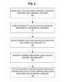
- FIG. 3 is a flow diagram of a process for indexing geo-temporal data in accordance with one or more embodiments described herein.
- geo-temporal input data is received that is associated with a geospatial component and a temporal component (block 300 ).
- the geo-temporal input data is indexed in a geospatial index based on the geospatial component (block 302 ).
- the geo-temporal data may be indexed in data repository 111 according to a geospatial indexing technique such as the techniques described above.
- temporal index configuration data is received specifying one or more time granularities (e.g., years, months, days, hours, etc.) (block 304 ).
- the temporal index configuration data may be specified by a user involved in the importation of input data 102 by using, for example, interface 114 .
- the particular time granularities may be specified as part of a data import configuration file or other user input mechanisms.
- the particular time granularities may be specified before, during, or after the input data 102 is imported into data repository 111 .
- geo-temporal data that has previously been geospatially indexed may be re-indexed based on a temporal component, or geo-temporal data of input data 102 may be contemporaneously geospatially and temporally indexed at the time of data importation.
- an index bucket group is generated for each time granularity specified in the temporal index configuration data (block 306 ).
- the generation of a temporal index bucket group includes storing a copy of the geospatial index data in one or more temporal index buckets.
- Each particular temporal index bucket in a temporal index bucket group represents a particular range of time spanning an amount of time equal to the time granularity of the temporal index bucket group.
- each temporal index bucket group stores a copy of the geospatial index data, with each index entry of the geospatial index stored in a particular temporal index bucket.
- the particular temporal index bucket storing each geospatial index entry is the temporal index bucket that is associated with a time range that includes the value specified by the temporal component of the data object referenced by the geospatial index entry. For example, if a temporal index bucket group is generated for a time granularity of years, and a particular data object of input data 102 includes a temporal component specifying a time value that falls within the year 2010, the geospatial index entry for that data object may be stored in a temporal index bucket representing the year 2010 in the year granularity temporal index bucket group.
- each temporal index bucket is stored in data repository 111 and represented by a row key in the distributed key-value data repository.
- the user-specified time granularities correspond to time granularities that are expected by the user or others to be specified in geo-temporal queries against the data as stored in data repository 111 .
- an analyst involved in the importation of geo-temporal data may be aware that users often desire to search for data objects associated with particular geographic regions and that are associated with temporal components within particular year time spans and/or particular hour time spans.
- an analyst involved in the importation of data may specify temporal index configuration data indicating two time granularities for the geo-temporal input data: a year time granularity and an hour time granularity.
- temporal index bucket group 112 B may correspond to the index bucket group for the hour granularity.
- generated temporal index buckets of temporal index bucket group 112 A may represent particular year timespans (e.g., 1978, 2002, 2009, 2012) and generated temporal index buckets of temporal index bucket group 112 B may represent particular day timespans (e.g., Mar. 15, 1978; Jan. 10, 2009).
- an indexed reference to the input data is stored in a particular temporal index bucket of each generated temporal index bucket group (block 308 ).
- a temporal index bucket in a particular temporal index bucket group does not yet exist for the temporal value specified by the input data, a new temporal index bucket is generated for the temporal index bucket group.
- a new temporal index bucket is generated.
- the following sections describe an example graphical user interface display for specifying a geo-temporal query.
- the graphical user interface display described herein represents only a selected example of a visualization for the geo-temporal query operations that are described herein.
- the disclosure broadly encompasses any method of creating and processing geo-temporal queries that are described herein.
- the geo-temporal search functionality is provided by a combination of a search mechanism 113 and the data repository 111 .
- the search functionality is provided entirely be the data repository 111 or a combination of the data repository 111 , a search mechanism 113 , and one or more other system component(s) are also possible.
- the example graphical user interface merely represents one way to receive input from a user to specify a geo-temporal query; in other embodiments, programmatic methods may be used to obtain the same query specification information and other forms of data output may be used such as logging, reporting, storing in database tables, storing in spreadsheets, etc.
- a search mechanism 113 receives as input a set of geo-temporal search parameters and provides as output a set of search results.
- FIG. 2 illustrates an example graphical user interface 200 that enables a user to specify a set of search parameters for a geo-temporal query.
- Graphical user interface 200 includes interface components that enable a user to specify both a geospatial bounding area and a time value or range of time values as geospatial and temporal search parameters, respectively.
- Interface component 204 illustrates a representation of a geographical map that may be used to specify one or more desired geospatial bounding areas.
- bounding area 206 represents an example bounding area that a user may specify on the map using an input mechanism such as, for example, a mouse pointer to draw the bounding area on the map.
- a specified bounding area such as bounding area 206 defines a geographical area of interest to the user that will be specified as a geospatial search parameter in a resulting geo-temporal query.
- a bounding area may be defined using a number of shapes including, but not limited to, a radial or polygonal bounding area.
- a user may additionally specify a temporal range of interest using graphical user interface 200 .
- a specified temporal range for a geo-temporal query may include one or more of a start date and/or time value and an end date and/or time value.
- Graphical interface component 202 illustrates an example interface component enabling a user to specify a temporal range as a search parameter.
- An interface component such as interface component 202 may include, among other input elements, one or more input elements for entering date and time values. For example, a user may enter one or more dates using text boxes, a calendar, or any other interface component for entering dates and/or time values.
- interface component 202 may include one or more additional input parameters enabling the specification of one or more other search parameters, for example, a search string, a sort order, etc.
- a geo-temporal query may be generated based on the input received at graphical user interface 200 .
- search mechanism may transform the user input received at graphical user interface 200 into a textual representation of a geo-temporal query that includes search parameters corresponding to the user input received at graphical user interface 200 .
- the geo-temporal query may be processed by search mechanism 113 .
- FIG. 4 illustrates a flow diagram of a process for carrying out a geo-temporal query in accordance with one or more of embodiments described herein.
- a search query is received (block 400 ) that includes both a geospatial component and a temporal component.
- one or more second queries are generated (block 402 ), with each of the second queries corresponding to a particular temporal index bucket of a temporal index bucket group.
- the temporal index buckets are selected to correspond to the temporal component of the query.
- a geo-temporal query is received that specifies a temporal range of Jan. 1, 2011 to Jan. 2, 2012
- the system may transform the geo-temporal query into a second query against the bucket corresponding to the data year 2011 and two additional second queries corresponding to the days of Jan. 1, 2012 and Jan. 2, 2012.
- processing each of the second queries includes processing the geospatial component of the geo-temporal query on the data stored in each of the buckets. For example, if the data in data repository 111 is geo spatially indexed using Z-order curve values, the geospatial component of the query may be transformed into one or more Z-order values and the values may be used to return corresponding results from each of the temporal index buckets. In an embodiment, the zero or more results returned from each of the one or more temporal index buckets are aggregated to form an initial result set.
- processing a geo-temporal query may include one more steps of post-filtering.
- the result set returned by the one or more second queries may include one or more data items that are not within the exact temporal range specified by the geo-temporal query.
- the search mechanism 113 may filter (block 406 ) the one or more results that are not within the specified temporal range. For example, assume that a geo-temporal index is created using a specified time granularity of an hour, resulting in a temporal index bucket group with one or more temporal index buckets of hour time ranges (e.g., 1:00 pm-2:00 pm, 2:00 pm-3:00 pm, 3:00 pm-4:00 pm, etc.).
- An example geo-temporal query may then include a temporal search parameter specifying a time range on a particular day between 2:15 pm and 3:15 pm.
- the search mechanism 113 may transform the query into two queries that query the temporal index buckets that index data objects associated with a temporal value between the time ranges of 2:00 pm-3:00 pm and 3:00 pm-4:00 pm, respectively.
- search mechanism 113 may post-filter the data object results in order to filter any data objects that are associated with a temporal value outside of the range specified in the query, i.e., those data objects in the temporal ranges of 2:00 pm-2:14 pm and 3:16 pm-4:00 pm.
- the techniques described herein are implemented by one or more special-purpose computing devices.
- the special-purpose computing devices may be hard-wired to perform the techniques, or may include digital electronic devices such as one or more application-specific integrated circuits (ASICs) or field programmable gate arrays (FPGAs) that are persistently programmed to perform the techniques, or may include one or more general purpose hardware processors programmed to perform the techniques pursuant to program instructions in firmware, memory, other storage, or a combination.
- ASICs application-specific integrated circuits
- FPGAs field programmable gate arrays
- Such special-purpose computing devices may also combine custom hard-wired logic, ASICs, or FPGAs with custom programming to accomplish the techniques.
- the special-purpose computing devices may be desktop computer systems, portable computer systems, handheld devices, networking devices or any other device that incorporates hard-wired and/or program logic to implement the techniques.
- FIG. 5 is a block diagram that illustrates a computer system 500 upon which an embodiment may be implemented.
- Computer system 500 includes a bus 502 or other communication mechanism for communicating information, and a hardware processor 504 coupled with bus 502 for processing information.
- Hardware processor 504 may be, for example, a general purpose microprocessor.
- Computer system 500 also includes a main memory 506 , such as a random access memory (RAM) or other dynamic storage device, coupled to bus 502 for storing information and instructions to be executed by processor 504 .
- Main memory 506 also may be used for storing temporary variables or other intermediate information during execution of instructions to be executed by processor 504 .
- Such instructions when stored in non-transitory storage media accessible to processor 504 , render computer system 500 into a special-purpose machine that is customized to perform the operations specified in the instructions.
- Computer system 500 further includes a read only memory (ROM) 508 or other static storage device coupled to bus 502 for storing static information and instructions for processor 504 .
- ROM read only memory
- a storage device 510 such as a magnetic disk, optical disk, or solid-state drive is provided and coupled to bus 502 for storing information and instructions.
- Computer system 500 may be coupled via bus 502 to a display 512 , such as a cathode ray tube (CRT), for displaying information to a computer user.
- a display 512 such as a cathode ray tube (CRT)
- An input device 514 is coupled to bus 502 for communicating information and command selections to processor 504 .
- cursor control 516 is Another type of user input device
- cursor control 516 such as a mouse, a trackball, or cursor direction keys for communicating direction information and command selections to processor 504 and for controlling cursor movement on display 512 .
- This input device typically has two degrees of freedom in two axes, a first axis (e.g., x) and a second axis (e.g., y), that allows the device to specify positions in a plane.
- Computer system 500 may implement the techniques described herein using customized hard-wired logic, one or more ASICs or FPGAs, firmware and/or program logic which in combination with the computer system causes or programs computer system 500 to be a special-purpose machine. According to one embodiment, the techniques herein are performed by computer system 500 in response to processor 504 executing one or more sequences of one or more instructions contained in main memory 506 . Such instructions may be read into main memory 506 from another storage medium, such as storage device 510 . Execution of the sequences of instructions contained in main memory 506 causes processor 504 to perform the process steps described herein. In alternative embodiments, hard-wired circuitry may be used in place of or in combination with software instructions.
- Non-volatile media includes, for example, optical disks, magnetic disks, or solid-state drives, such as storage device 510 .
- Volatile media includes dynamic memory, such as main memory 506 .
- storage media include, for example, a floppy disk, a flexible disk, hard disk, solid-state drive, magnetic tape, or any other magnetic data storage medium, a CD-ROM, any other optical data storage medium, any physical medium with patterns of holes, a RAM, a PROM, and EPROM, a FLASH-EPROM, NVRAM, any other memory chip or cartridge.
- Storage media is distinct from but may be used in conjunction with transmission media.
- Transmission media participates in transferring information between storage media.
- transmission media includes coaxial cables, copper wire and fiber optics, including the wires that comprise bus 502 .
- transmission media can also take the form of acoustic or light waves, such as those generated during radio-wave and infra-red data communications.
- Various forms of media may be involved in carrying one or more sequences of one or more instructions to processor 504 for execution.
- the instructions may initially be carried on a magnetic disk or solid-state drive of a remote computer.
- the remote computer can load the instructions into its dynamic memory and send the instructions over a telephone line using a modem.
- a modem local to computer system 500 can receive the data on the telephone line and use an infra-red transmitter to convert the data to an infra-red signal.
- An infra-red detector can receive the data carried in the infra-red signal and appropriate circuitry can place the data on bus 502 .
- Bus 502 carries the data to main memory 506 , from which processor 504 retrieves and executes the instructions.
- the instructions received by main memory 506 may optionally be stored on storage device 510 either before or after execution by processor 504 .
- Computer system 500 also includes a communication interface 518 coupled to bus 502 .
- Communication interface 518 provides a two-way data communication coupling to a network link 520 that is connected to a local network 522 .
- communication interface 518 may be an integrated services digital network (ISDN) card, cable modem, satellite modem, or a modem to provide a data communication connection to a corresponding type of telephone line.
- ISDN integrated services digital network
- communication interface 518 may be a local area network (LAN) card to provide a data communication connection to a compatible LAN.
- LAN local area network
- Wireless links may also be implemented.
- communication interface 518 sends and receives electrical, electromagnetic or optical signals that carry digital data streams representing various types of information.
- Network link 520 typically provides data communication through one or more networks to other data devices.
- network link 520 may provide a connection through local network 522 to a host computer 524 or to data equipment operated by an Internet Service Provider (ISP) 526 .
- ISP 526 in turn provides data communication services through the world wide packet data communication network now commonly referred to as the “Internet” 528 .
- Internet 528 uses electrical, electromagnetic or optical signals that carry digital data streams.
- the signals through the various networks and the signals on network link 520 and through communication interface 518 which carry the digital data to and from computer system 500 , are example forms of transmission media.
- Computer system 500 can send messages and receive data, including program code, through the network(s), network link 520 and communication interface 518 .
- a server 530 might transmit a requested code for an application program through Internet 528 , ISP 526 , local network 522 and communication interface 518 .
- the received code may be executed by processor 504 as it is received, and/or stored in storage device 510 , or other non-volatile storage for later execution.
Abstract
Description
-
- 1.0 General Overview
- 2.0 Structural and Functional Overview
- 2.1 Data Sources
- 2.2 Data Repository
- 2.3 Geo-temporal Data Importation
- 2.3.1 Indexing Geospatial Data
- 2.3.2 Indexing Geo-temporal Data
- 3.0 Example Geo-temporal Search Operation
- 4.0 Implementation Mechanisms—Hardware Overview
Claims (14)
Priority Applications (2)
| Application Number | Priority Date | Filing Date | Title |
|---|---|---|---|
| US13/728,879 US9501507B1 (en) | 2012-12-27 | 2012-12-27 | Geo-temporal indexing and searching |
| US15/358,002 US10691662B1 (en) | 2012-12-27 | 2016-11-21 | Geo-temporal indexing and searching |
Applications Claiming Priority (1)
| Application Number | Priority Date | Filing Date | Title |
|---|---|---|---|
| US13/728,879 US9501507B1 (en) | 2012-12-27 | 2012-12-27 | Geo-temporal indexing and searching |
Related Child Applications (1)
| Application Number | Title | Priority Date | Filing Date |
|---|---|---|---|
| US15/358,002 Continuation US10691662B1 (en) | 2012-12-27 | 2016-11-21 | Geo-temporal indexing and searching |
Publications (1)
| Publication Number | Publication Date |
|---|---|
| US9501507B1 true US9501507B1 (en) | 2016-11-22 |
Family
ID=57287706
Family Applications (2)
| Application Number | Title | Priority Date | Filing Date |
|---|---|---|---|
| US13/728,879 Active 2034-08-06 US9501507B1 (en) | 2012-12-27 | 2012-12-27 | Geo-temporal indexing and searching |
| US15/358,002 Active 2034-12-24 US10691662B1 (en) | 2012-12-27 | 2016-11-21 | Geo-temporal indexing and searching |
Family Applications After (1)
| Application Number | Title | Priority Date | Filing Date |
|---|---|---|---|
| US15/358,002 Active 2034-12-24 US10691662B1 (en) | 2012-12-27 | 2016-11-21 | Geo-temporal indexing and searching |
Country Status (1)
| Country | Link |
|---|---|
| US (2) | US9501507B1 (en) |
Cited By (14)
| Publication number | Priority date | Publication date | Assignee | Title |
|---|---|---|---|---|
| CN108460094A (en) * | 2018-01-30 | 2018-08-28 | 上海天旦网络科技发展有限公司 | The method and system of storage statistical data |
| US10169081B2 (en) * | 2016-10-31 | 2019-01-01 | Oracle International Corporation | Use of concurrent time bucket generations for scalable scheduling of operations in a computer system |
| US10180863B2 (en) | 2016-10-31 | 2019-01-15 | Oracle International Corporation | Determining system information based on object mutation events |
| US10191936B2 (en) | 2016-10-31 | 2019-01-29 | Oracle International Corporation | Two-tier storage protocol for committing changes in a storage system |
| US10275177B2 (en) | 2016-10-31 | 2019-04-30 | Oracle International Corporation | Data layout schemas for seamless data migration |
| US10506380B2 (en) | 2016-12-22 | 2019-12-10 | Nokia Solutions And Networks Oy | User motion profiling based on user equipment cell location |
| CN111352956A (en) * | 2020-02-24 | 2020-06-30 | 交通运输部水运科学研究所 | Acquisition and storage system for shipping big data |
| US10733159B2 (en) | 2016-09-14 | 2020-08-04 | Oracle International Corporation | Maintaining immutable data and mutable metadata in a storage system |
| US10860534B2 (en) | 2016-10-27 | 2020-12-08 | Oracle International Corporation | Executing a conditional command on an object stored in a storage system |
| US10956051B2 (en) | 2016-10-31 | 2021-03-23 | Oracle International Corporation | Data-packed storage containers for streamlined access and migration |
| US20210406328A1 (en) * | 2020-06-30 | 2021-12-30 | Amazon Technologies, Inc. | Spatial search using key-value store |
| US11726979B2 (en) | 2016-09-13 | 2023-08-15 | Oracle International Corporation | Determining a chronological order of transactions executed in relation to an object stored in a storage system |
| US11775545B1 (en) | 2020-09-23 | 2023-10-03 | Amazon Technologies, Inc. | Cloud-based database for spatial data lifecycle management |
| US11947555B1 (en) * | 2022-09-30 | 2024-04-02 | Amazon Technologies, Inc. | Intelligent query routing across shards of scalable database tables |
Families Citing this family (3)
| Publication number | Priority date | Publication date | Assignee | Title |
|---|---|---|---|---|
| US11321295B2 (en) * | 2019-11-14 | 2022-05-03 | Acronis International Gmbh | Systems and methods for improving indexer performance by multiplexing data of an underlying index |
| US11366810B2 (en) * | 2020-04-27 | 2022-06-21 | Salesforce.Com, Inc. | Index contention under high concurrency in a database system |
| US20220221297A1 (en) * | 2020-06-02 | 2022-07-14 | FLIR Belgium BVBA | Waypoint timeline user interface systems and methods |
Citations (16)
| Publication number | Priority date | Publication date | Assignee | Title |
|---|---|---|---|---|
| US20060259527A1 (en) * | 2005-05-13 | 2006-11-16 | Devarakonda Murthy V | Changed files list with time buckets for efficient storage management |
| US20070115373A1 (en) * | 2005-11-22 | 2007-05-24 | Eastman Kodak Company | Location based image classification with map segmentation |
| US20080229056A1 (en) * | 2007-03-12 | 2008-09-18 | Broadcom Corporation | Method and apparatus for dual-hashing tables |
| US7617314B1 (en) * | 2005-05-20 | 2009-11-10 | Network General Technology | HyperLock technique for high-speed network data monitoring |
| US20100185692A1 (en) * | 2009-01-20 | 2010-07-22 | Bin Zhang | System and method for determining intervals of a space filling curve in a query box |
| US20100277611A1 (en) * | 2009-05-01 | 2010-11-04 | Adam Holt | Automatic content tagging, such as tagging digital images via a wireless cellular network using metadata and facial recognition |
| US20110022312A1 (en) * | 2009-07-23 | 2011-01-27 | Fmr Llc | Generating and Tracking Activity Patterns for Mobile Devices |
| US8200676B2 (en) * | 2005-06-28 | 2012-06-12 | Nokia Corporation | User interface for geographic search |
| US20120159363A1 (en) * | 2010-12-16 | 2012-06-21 | Microsoft Corporation | Z-order bands |
| US8407180B1 (en) * | 2010-11-29 | 2013-03-26 | Teradata Us, Inc. | Eliminating inner joins based on a temporal relationship constraint |
| US8412234B1 (en) * | 2011-12-07 | 2013-04-02 | Sprint Communications Company L.P. | Clustering location and time for location prediction |
| US20130132398A1 (en) * | 2011-11-22 | 2013-05-23 | Martin Pfeifle | Location Based Full Text Search |
| US20130282723A1 (en) * | 2009-02-02 | 2013-10-24 | Waldeck Technology, Llc | Maintaining A Historical Record Of Anonymized User Profile Data By Location For Users In A Mobile Environment |
| US20140176606A1 (en) * | 2012-12-20 | 2014-06-26 | Analytical Graphics Inc. | Recording and visualizing images using augmented image data |
| US20140361899A1 (en) * | 2012-01-06 | 2014-12-11 | 3M Innovative Properties Company | Released offender geospatial location information trend analysis |
| US8983494B1 (en) * | 2013-02-08 | 2015-03-17 | Urban Airship, Inc. | Processing location information |
Family Cites Families (322)
| Publication number | Priority date | Publication date | Assignee | Title |
|---|---|---|---|---|
| US4958305A (en) | 1987-11-04 | 1990-09-18 | General Electric Company | Polygon edge clipping |
| US4899161A (en) | 1988-07-21 | 1990-02-06 | International Business Machines Corporation | High accuracy coordinate conversion method for air traffic control applications |
| FR2684214B1 (en) | 1991-11-22 | 1997-04-04 | Sepro Robotique | INDEXING CARD FOR GEOGRAPHIC INFORMATION SYSTEM AND SYSTEM INCLUDING APPLICATION. |
| IL113805A0 (en) | 1994-05-23 | 1995-08-31 | Coulter Corp | Detection of reticulocytes |
| JP3252623B2 (en) | 1994-11-09 | 2002-02-04 | 松下電器産業株式会社 | Shape model generator |
| US5781195A (en) | 1996-04-16 | 1998-07-14 | Microsoft Corporation | Method and system for rendering two-dimensional views of a three-dimensional surface |
| US6169552B1 (en) | 1996-04-16 | 2001-01-02 | Xanavi Informatics Corporation | Map display device, navigation device and map display method |
| US6178432B1 (en) | 1996-09-30 | 2001-01-23 | Informative Graphics Corp. | Method and apparatus for creating interactive web page objects |
| CA2187704C (en) | 1996-10-11 | 1999-05-04 | Darcy Kim Rossmo | Expert system method of performing crime site analysis |
| US5870559A (en) | 1996-10-15 | 1999-02-09 | Mercury Interactive | Software system and associated methods for facilitating the analysis and management of web sites |
| US6275233B1 (en) | 1996-11-01 | 2001-08-14 | International Business Machines Corporation | Surface simplification preserving a solid volume |
| US6430305B1 (en) | 1996-12-20 | 2002-08-06 | Synaptics, Incorporated | Identity verification methods |
| US6026233A (en) | 1997-05-27 | 2000-02-15 | Microsoft Corporation | Method and apparatus for presenting and selecting options to modify a programming language statement |
| US6091956A (en) | 1997-06-12 | 2000-07-18 | Hollenberg; Dennis D. | Situation information system |
| US6157747A (en) | 1997-08-01 | 2000-12-05 | Microsoft Corporation | 3-dimensional image rotation method and apparatus for producing image mosaics |
| US6247019B1 (en) | 1998-03-17 | 2001-06-12 | Prc Public Sector, Inc. | Object-based geographic information system (GIS) |
| US6173067B1 (en) | 1998-04-07 | 2001-01-09 | Hughes Electronics Corporation | System and method for rapid determination of visibility-based terrain properties over broad regions |
| US6389289B1 (en) | 1998-05-07 | 2002-05-14 | Hughes Electronics Corporation | Earth tiling system for providing regional based service in a mobile satellite communication network |
| US7168039B2 (en) | 1998-06-02 | 2007-01-23 | International Business Machines Corporation | Method and system for reducing the horizontal space required for displaying a column containing text data |
| US6577304B1 (en) | 1998-08-14 | 2003-06-10 | I2 Technologies Us, Inc. | System and method for visually representing a supply chain |
| US6529900B1 (en) | 1999-01-14 | 2003-03-04 | International Business Machines Corporation | Method and apparatus for data visualization |
| US6662103B1 (en) | 1999-03-22 | 2003-12-09 | Arc Second Inc. | Method and system for creating a user-selectable arbitrary coordinate frame |
| US6631496B1 (en) | 1999-03-22 | 2003-10-07 | Nec Corporation | System for personalizing, organizing and managing web information |
| US6483509B1 (en) | 1999-04-09 | 2002-11-19 | International Business Machines Corp. | Curve contour smoothing |
| US6307573B1 (en) | 1999-07-22 | 2001-10-23 | Barbara L. Barros | Graphic-information flow method and system for visually analyzing patterns and relationships |
| JP2003519828A (en) | 1999-09-21 | 2003-06-24 | チョイスメーカー テクノロジーズ インコーポレイテッド | Probabilistic record link model derived from training data |
| EP1113400A3 (en) | 1999-12-27 | 2011-08-03 | Minolta Co., Ltd. | Method and apparatus for reducing three-dimensional shape data |
| US8868535B1 (en) * | 2000-02-24 | 2014-10-21 | Richard Paiz | Search engine optimizer |
| US7148898B1 (en) | 2000-03-29 | 2006-12-12 | Sourceprose Corporation | System and method for synchronizing raster and vector map images |
| JP4325075B2 (en) | 2000-04-21 | 2009-09-02 | ソニー株式会社 | Data object management device |
| WO2001098925A2 (en) | 2000-06-20 | 2001-12-27 | Globexplorer, Inc. | Method, system and computer program product for delivering spatially referenced information in a global computer network |
| US6983203B1 (en) | 2000-07-28 | 2006-01-03 | Alpine Electronics, Inc. | POI icon display method and navigation system |
| US6484101B1 (en) | 2000-08-16 | 2002-11-19 | Imagelinks, Inc. | 3-dimensional interactive image modeling system |
| US20020065708A1 (en) | 2000-09-22 | 2002-05-30 | Hikmet Senay | Method and system for interactive visual analyses of organizational interactions |
| US6757445B1 (en) | 2000-10-04 | 2004-06-29 | Pixxures, Inc. | Method and apparatus for producing digital orthophotos using sparse stereo configurations and external models |
| US8707185B2 (en) | 2000-10-10 | 2014-04-22 | Addnclick, Inc. | Dynamic information management system and method for content delivery and sharing in content-, metadata- and viewer-based, live social networking among users concurrently engaged in the same and/or similar content |
| US8117281B2 (en) | 2006-11-02 | 2012-02-14 | Addnclick, Inc. | Using internet content as a means to establish live social networks by linking internet users to each other who are simultaneously engaged in the same and/or similar content |
| US6754640B2 (en) | 2000-10-30 | 2004-06-22 | William O. Bozeman | Universal positive pay match, authentication, authorization, settlement and clearing system |
| US6978419B1 (en) | 2000-11-15 | 2005-12-20 | Justsystem Corporation | Method and apparatus for efficient identification of duplicate and near-duplicate documents and text spans using high-discriminability text fragments |
| US20020103705A1 (en) | 2000-12-06 | 2002-08-01 | Forecourt Communication Group | Method and apparatus for using prior purchases to select activities to present to a customer |
| US7529698B2 (en) | 2001-01-16 | 2009-05-05 | Raymond Anthony Joao | Apparatus and method for providing transaction history information, account history information, and/or charge-back information |
| US6516268B2 (en) | 2001-02-16 | 2003-02-04 | Wizeguides.Com Inc. | Bundled map guide |
| US6985950B1 (en) | 2001-03-06 | 2006-01-10 | Microsoft Corporation | System for creating a space-efficient document categorizer for training and testing of automatic categorization engines |
| TW493142B (en) | 2001-03-14 | 2002-07-01 | Ind Tech Res Inst | Method for building progressive mesh |
| US7076741B2 (en) | 2001-03-16 | 2006-07-11 | Alpine Electronics, Inc. | Point-of-interest icon and point-of-interest mark display method |
| US6996782B2 (en) | 2001-05-23 | 2006-02-07 | Eastman Kodak Company | Using digital objects organized according to a histogram timeline |
| US8028249B2 (en) | 2001-05-23 | 2011-09-27 | Eastman Kodak Company | Method and system for browsing large digital multimedia object collections |
| US6828920B2 (en) | 2001-06-04 | 2004-12-07 | Lockheed Martin Orincon Corporation | System and method for classifying vehicles |
| WO2003032125A2 (en) | 2001-10-11 | 2003-04-17 | Visualsciences, Llc | System, method, and computer program product for processing and visualization of information |
| US6744434B2 (en) | 2001-11-30 | 2004-06-01 | Caterpillar Inc | Cuts removal system for triangulated CAD Models |
| WO2003047746A1 (en) | 2001-12-06 | 2003-06-12 | Mitsubishi Chemical Corporation | Oxidation reactor, method for producing (meth)acrylic acid or the like, and method for analyzing easily polymerizable compound |
| US7970240B1 (en) | 2001-12-17 | 2011-06-28 | Google Inc. | Method and apparatus for archiving and visualizing digital images |
| US7640173B2 (en) | 2002-01-17 | 2009-12-29 | Applied Medical Software, Inc. | Method and system for evaluating a physician's economic performance and gainsharing of physician services |
| US7546245B2 (en) | 2002-01-17 | 2009-06-09 | Amsapplied Medical Software, Inc. | Method and system for gainsharing of physician services |
| US7653594B2 (en) | 2002-03-20 | 2010-01-26 | Catalina Marketing Corporation | Targeted incentives based upon predicted behavior |
| US7533026B2 (en) | 2002-04-12 | 2009-05-12 | International Business Machines Corporation | Facilitating management of service elements usable in providing information technology service offerings |
| US20030200192A1 (en) | 2002-04-18 | 2003-10-23 | Bell Brian L. | Method of organizing information into topical, temporal, and location associations for organizing, selecting, and distributing information |
| JP2003345810A (en) | 2002-05-28 | 2003-12-05 | Hitachi Ltd | Method and system for document retrieval and document retrieval result display system |
| US7872647B2 (en) | 2002-07-19 | 2011-01-18 | Rockwell Collins Simulation And Training Solutions Llc | System and method for modeling a spheroid world database |
| US6847888B2 (en) | 2002-08-07 | 2005-01-25 | Hrl Laboratories, Llc | Method and apparatus for geographic shape preservation for identification |
| US6728608B2 (en) | 2002-08-23 | 2004-04-27 | Applied Perception, Inc. | System and method for the creation of a terrain density model |
| US20040143602A1 (en) | 2002-10-18 | 2004-07-22 | Antonio Ruiz | Apparatus, system and method for automated and adaptive digital image/video surveillance for events and configurations using a rich multimedia relational database |
| IL153535A (en) | 2002-12-19 | 2007-12-03 | Rafael Advanced Defense Sys | Method and system for processing and analyzing digital terrain data |
| US8589273B2 (en) | 2002-12-23 | 2013-11-19 | Ge Corporate Financial Services, Inc. | Methods and systems for managing risk management information |
| US7752117B2 (en) | 2003-01-31 | 2010-07-06 | Trading Technologies International, Inc. | System and method for money management in electronic trading environment |
| US20040153418A1 (en) | 2003-02-05 | 2004-08-05 | Hanweck Gerald Alfred | System and method for providing access to data from proprietary tools |
| US7133054B2 (en) | 2004-03-17 | 2006-11-07 | Seadragon Software, Inc. | Methods and apparatus for navigating an image |
| US7562289B2 (en) | 2003-06-18 | 2009-07-14 | Layton Geo-Science, Inc. | Methods and systems for encoding geographic coordinates and features in a portable document format file |
| US8412566B2 (en) | 2003-07-08 | 2013-04-02 | Yt Acquisition Corporation | High-precision customer-based targeting by individual usage statistics |
| CA2436312C (en) | 2003-08-01 | 2011-04-05 | Perry Peterson | Close-packed, uniformly adjacent, multiresolutional, overlapping spatial data ordering |
| WO2005036319A2 (en) | 2003-09-22 | 2005-04-21 | Catalina Marketing International, Inc. | Assumed demographics, predicted behaviour, and targeted incentives |
| US7334195B2 (en) | 2003-10-14 | 2008-02-19 | Microsoft Corporation | System and process for presenting search results in a histogram/cluster format |
| US7584172B2 (en) | 2003-10-16 | 2009-09-01 | Sap Ag | Control for selecting data query and visual configuration |
| US7917376B2 (en) | 2003-12-29 | 2011-03-29 | Montefiore Medical Center | System and method for monitoring patient care |
| US7872669B2 (en) | 2004-01-22 | 2011-01-18 | Massachusetts Institute Of Technology | Photo-based mobile deixis system and related techniques |
| US7343272B2 (en) | 2004-02-12 | 2008-03-11 | International Business Machines Corporation | System and method for detecting generalized space-time clusters |
| US20050182793A1 (en) | 2004-02-18 | 2005-08-18 | Keenan Viktor M. | Map structure and method for producing |
| US20050206751A1 (en) | 2004-03-19 | 2005-09-22 | East Kodak Company | Digital video system for assembling video sequences |
| CA2560386C (en) | 2004-03-23 | 2013-09-24 | Google Inc. | A digital mapping system |
| US7865301B2 (en) | 2004-03-23 | 2011-01-04 | Google Inc. | Secondary map in digital mapping system |
| US7599790B2 (en) | 2004-03-23 | 2009-10-06 | Google Inc. | Generating and serving tiles in a digital mapping system |
| US20060026120A1 (en) | 2004-03-24 | 2006-02-02 | Update Publications Lp | Method and system for collecting, processing, and distributing residential property data |
| US7269801B2 (en) | 2004-03-30 | 2007-09-11 | Autodesk, Inc. | System for managing the navigational usability of an interactive map |
| US7539666B2 (en) | 2004-04-06 | 2009-05-26 | International Business Machines Corporation | Method, system and program for managing geographic data stored in a database |
| US7280897B2 (en) | 2004-05-28 | 2007-10-09 | Lockheed Martin Corporation | Intervisibility determination |
| US8953887B2 (en) * | 2004-07-09 | 2015-02-10 | Terrago Technologies, Inc. | Processing time-based geospatial data |
| WO2006012645A2 (en) | 2004-07-28 | 2006-02-02 | Sarnoff Corporation | Method and apparatus for total situational awareness and monitoring |
| US7529195B2 (en) | 2004-07-30 | 2009-05-05 | Fortiusone, Inc. | System and method of mapping and analyzing vulnerabilities in networks |
| US7617232B2 (en) | 2004-09-02 | 2009-11-10 | Microsoft Corporation | Centralized terminology and glossary development |
| US7620628B2 (en) | 2004-12-06 | 2009-11-17 | Yahoo! Inc. | Search processing with automatic categorization of queries |
| US20060143079A1 (en) | 2004-12-29 | 2006-06-29 | Jayanta Basak | Cross-channel customer matching |
| JP2006190049A (en) | 2005-01-05 | 2006-07-20 | Fujitsu Ltd | Method and device for drawing apex reduced pattern |
| US9436945B2 (en) | 2005-02-01 | 2016-09-06 | Redfin Corporation | Interactive map-based search and advertising |
| US20060200384A1 (en) | 2005-03-03 | 2006-09-07 | Arutunian Ethan B | Enhanced map imagery, such as for location-based advertising and location-based reporting |
| US8091784B1 (en) | 2005-03-09 | 2012-01-10 | Diebold, Incorporated | Banking system controlled responsive to data bearing records |
| US7596528B1 (en) | 2005-03-31 | 2009-09-29 | Trading Technologies International, Inc. | System and method for dynamically regulating order entry in an electronic trading environment |
| US7746340B2 (en) | 2005-04-13 | 2010-06-29 | Siemens Medical Solutions Usa, Inc. | Method and apparatus for generating a 2D image having pixels corresponding to voxels of a 3D image |
| US8082172B2 (en) | 2005-04-26 | 2011-12-20 | The Advisory Board Company | System and method for peer-profiling individual performance |
| US7672968B2 (en) | 2005-05-12 | 2010-03-02 | Apple Inc. | Displaying a tooltip associated with a concurrently displayed database object |
| US8825370B2 (en) | 2005-05-27 | 2014-09-02 | Yahoo! Inc. | Interactive map-based travel guide |
| US8341259B2 (en) | 2005-06-06 | 2012-12-25 | Adobe Systems Incorporated | ASP for web analytics including a real-time segmentation workbench |
| EP1732034A1 (en) | 2005-06-06 | 2006-12-13 | First Data Corporation | System and method for authorizing electronic payment transactions |
| US20070016363A1 (en) | 2005-07-15 | 2007-01-18 | Oracle International Corporation | Interactive map-based user interface for transportation planning |
| CA2615659A1 (en) | 2005-07-22 | 2007-05-10 | Yogesh Chunilal Rathod | Universal knowledge management and desktop search system |
| US7586489B2 (en) | 2005-08-01 | 2009-09-08 | Nvidia Corporation | Method of generating surface defined by boundary of three-dimensional point cloud |
| US7376516B2 (en) | 2005-08-23 | 2008-05-20 | R.A. Smith National | High accuracy survey grade GIS system |
| JP2007079641A (en) | 2005-09-09 | 2007-03-29 | Canon Inc | Information processor and processing method, program, and storage medium |
| US8095866B2 (en) | 2005-09-09 | 2012-01-10 | Microsoft Corporation | Filtering user interface for a data summary table |
| US7716226B2 (en) | 2005-09-27 | 2010-05-11 | Patentratings, Llc | Method and system for probabilistically quantifying and visualizing relevance between two or more citationally or contextually related data objects |
| US20070078832A1 (en) | 2005-09-30 | 2007-04-05 | Yahoo! Inc. | Method and system for using smart tags and a recommendation engine using smart tags |
| US7574428B2 (en) | 2005-10-11 | 2009-08-11 | Telmap Ltd | Geometry-based search engine for navigation systems |
| US7933897B2 (en) | 2005-10-12 | 2011-04-26 | Google Inc. | Entity display priority in a distributed geographic information system |
| US20090168163A1 (en) | 2005-11-01 | 2009-07-02 | Global Bionic Optics Pty Ltd. | Optical lens systems |
| US20100198858A1 (en) | 2005-11-21 | 2010-08-05 | Anti-Gang Enforcement Networking Technology, Inc. | System and Methods for Linking Multiple Events Involving Firearms and Gang Related Activities |
| US9141913B2 (en) | 2005-12-16 | 2015-09-22 | Nextbio | Categorization and filtering of scientific data |
| CN100481077C (en) | 2006-01-12 | 2009-04-22 | 国际商业机器公司 | Visual method and device for strengthening search result guide |
| US7791616B2 (en) | 2006-02-10 | 2010-09-07 | The United States Of America As Represented By The Secretary Of The Navy | Method for efficiently transforming a raster image from one map projection to another map projection |
| US20070208498A1 (en) | 2006-03-03 | 2007-09-06 | Inrix, Inc. | Displaying road traffic condition information and user controls |
| US7899611B2 (en) | 2006-03-03 | 2011-03-01 | Inrix, Inc. | Detecting anomalous road traffic conditions |
| US7579965B2 (en) | 2006-03-03 | 2009-08-25 | Andrew Bucholz | Vehicle data collection and processing system |
| US7519470B2 (en) | 2006-03-15 | 2009-04-14 | Microsoft Corporation | Location-based caching for mobile devices |
| EP1840520B1 (en) | 2006-03-31 | 2008-09-24 | Research In Motion Limited | User interface methods and apparatus for controlling the visual display of maps having selectable map elements in mobile communications devices |
| US8712192B2 (en) | 2006-04-20 | 2014-04-29 | Microsoft Corporation | Geo-coding images |
| JP4887359B2 (en) | 2006-04-24 | 2012-02-29 | パナソニック株式会社 | Drawing apparatus and drawing method |
| US7945852B1 (en) | 2006-05-19 | 2011-05-17 | Washington State University Research Foundation | Strategies for annotating digital maps |
| US8571580B2 (en) | 2006-06-01 | 2013-10-29 | Loopt Llc. | Displaying the location of individuals on an interactive map display on a mobile communication device |
| US9195985B2 (en) | 2006-06-08 | 2015-11-24 | Iii Holdings 1, Llc | Method, system, and computer program product for customer-level data verification |
| US20080010273A1 (en) | 2006-06-12 | 2008-01-10 | Metacarta, Inc. | Systems and methods for hierarchical organization and presentation of geographic search results |
| US7468662B2 (en) | 2006-06-16 | 2008-12-23 | International Business Machines Corporation | Method for spatio-temporal event detection using composite definitions for camera systems |
| US8290943B2 (en) | 2006-07-14 | 2012-10-16 | Raytheon Company | Geographical information display system and method |
| EP2050016A4 (en) | 2006-08-10 | 2009-10-21 | Univ Loma Linda Med | Advanced emergency geographical information system |
| US20130150004A1 (en) | 2006-08-11 | 2013-06-13 | Michael Rosen | Method and apparatus for reducing mobile phone usage while driving |
| US20080040678A1 (en) | 2006-08-14 | 2008-02-14 | Richard Crump | Interactive Area Guide Method, System and Apparatus |
| US20080040684A1 (en) | 2006-08-14 | 2008-02-14 | Richard Crump | Intelligent Pop-Up Window Method and Apparatus |
| JP4778865B2 (en) | 2006-08-30 | 2011-09-21 | 株式会社ソニー・コンピュータエンタテインメント | Image viewer, image display method and program |
| US8054756B2 (en) | 2006-09-18 | 2011-11-08 | Yahoo! Inc. | Path discovery and analytics for network data |
| US20090300528A1 (en) | 2006-09-29 | 2009-12-03 | Stambaugh Thomas M | Browser event tracking for distributed web-based processing, spatial organization and display of information |
| US20080082578A1 (en) | 2006-09-29 | 2008-04-03 | Andrew Hogue | Displaying search results on a one or two dimensional graph |
| US8060556B2 (en) | 2006-10-20 | 2011-11-15 | Sap Ag | Service enabled tagged user interfaces |
| US7698336B2 (en) | 2006-10-26 | 2010-04-13 | Microsoft Corporation | Associating geographic-related information with objects |
| US8065080B2 (en) | 2006-10-31 | 2011-11-22 | At&T Intellectual Property I, Lp | Location stamping and logging of electronic events and habitat generation |
| US8229902B2 (en) | 2006-11-01 | 2012-07-24 | Ab Initio Technology Llc | Managing storage of individually accessible data units |
| US7663621B1 (en) | 2006-11-03 | 2010-02-16 | Nvidia Corporation | Cylindrical wrapping using shader hardware |
| RU2009131042A (en) | 2006-11-13 | 2011-02-20 | Теле Атлас Норт Америка, Инк. (Us) | SYSTEM AND METHOD FOR PROVIDING MULTIPLE PARTICIPANTS OF THE CENTRAL PORTAL WITH ACCESS TO GEOGRAPHICAL DATA OF INFRASTRUCTURE OBJECTS |
| KR100861652B1 (en) | 2006-11-17 | 2008-10-02 | 엔에이치엔(주) | Map service system and method |
| US7962495B2 (en) | 2006-11-20 | 2011-06-14 | Palantir Technologies, Inc. | Creating data in a data store using a dynamic ontology |
| US8036632B1 (en) | 2007-02-02 | 2011-10-11 | Resource Consortium Limited | Access of information using a situational network |
| US7809703B2 (en) | 2006-12-22 | 2010-10-05 | International Business Machines Corporation | Usage of development context in search operations |
| US8290838B1 (en) | 2006-12-29 | 2012-10-16 | Amazon Technologies, Inc. | Indicating irregularities in online financial transactions |
| US8368695B2 (en) | 2007-02-08 | 2013-02-05 | Microsoft Corporation | Transforming offline maps into interactive online maps |
| WO2008100938A2 (en) | 2007-02-13 | 2008-08-21 | Fortiusone, Inc. | A method and system for integrating a social network and data repository to enable map creation |
| US7920963B2 (en) | 2007-02-22 | 2011-04-05 | Iac Search & Media, Inc. | Map interface with a movable marker |
| US20080208820A1 (en) * | 2007-02-28 | 2008-08-28 | Psydex Corporation | Systems and methods for performing semantic analysis of information over time and space |
| JP4833890B2 (en) | 2007-03-12 | 2011-12-07 | 東京エレクトロン株式会社 | Plasma processing apparatus and plasma distribution correction method |
| US8084712B2 (en) | 2007-03-16 | 2011-12-27 | TEN Medias LLC | Method and apparatus for laser marking objects |
| US8036971B2 (en) | 2007-03-30 | 2011-10-11 | Palantir Technologies, Inc. | Generating dynamic date sets that represent market conditions |
| JP5268274B2 (en) | 2007-03-30 | 2013-08-21 | キヤノン株式会社 | Search device, method, and program |
| US20080255973A1 (en) | 2007-04-10 | 2008-10-16 | Robert El Wade | Sales transaction analysis tool and associated method of use |
| WO2008131022A1 (en) | 2007-04-17 | 2008-10-30 | Guava Technologies, Inc. | Graphical user interface for analysis and comparison of location-specific multiparameter data sets |
| US8078641B2 (en) | 2007-04-25 | 2011-12-13 | Mitac International Corporation | Adjusting spatial operations based on map density |
| US20080267107A1 (en) | 2007-04-27 | 2008-10-30 | Outland Research, Llc | Attraction wait-time inquiry apparatus, system and method |
| US8515207B2 (en) | 2007-05-25 | 2013-08-20 | Google Inc. | Annotations in panoramic images, and applications thereof |
| US7809785B2 (en) | 2007-05-28 | 2010-10-05 | Google Inc. | System using router in a web browser for inter-domain communication |
| US8739123B2 (en) | 2007-05-28 | 2014-05-27 | Google Inc. | Incorporating gadget functionality on webpages |
| US7930547B2 (en) | 2007-06-15 | 2011-04-19 | Alcatel-Lucent Usa Inc. | High accuracy bloom filter using partitioned hashing |
| US20090027418A1 (en) | 2007-07-24 | 2009-01-29 | Maru Nimit H | Map-based interfaces for storing and locating information about geographical areas |
| US8631015B2 (en) | 2007-09-06 | 2014-01-14 | Linkedin Corporation | Detecting associates |
| US20090088964A1 (en) | 2007-09-28 | 2009-04-02 | Dave Schaaf | Map scrolling method and apparatus for navigation system for selectively displaying icons |
| US8849728B2 (en) | 2007-10-01 | 2014-09-30 | Purdue Research Foundation | Visual analytics law enforcement tools |
| US8484115B2 (en) | 2007-10-03 | 2013-07-09 | Palantir Technologies, Inc. | Object-oriented time series generator |
| US20090100018A1 (en) | 2007-10-12 | 2009-04-16 | Jonathan Roberts | System and method for capturing, integrating, discovering, and using geo-temporal data |
| US8214308B2 (en) | 2007-10-23 | 2012-07-03 | Sas Institute Inc. | Computer-implemented systems and methods for updating predictive models |
| US7650310B2 (en) | 2007-10-30 | 2010-01-19 | Intuit Inc. | Technique for reducing phishing |
| US8019709B2 (en) | 2007-11-09 | 2011-09-13 | Vantrix Corporation | Method and system for rule-based content filtering |
| EP2220457B1 (en) | 2007-11-09 | 2016-06-22 | TeleCommunication Systems, Inc. | Points-of-interest panning on a displayed map with a persistent search on a wireless phone |
| US8423425B2 (en) | 2007-11-14 | 2013-04-16 | Panjiva, Inc. | Evaluating public records of supply transactions for financial investment decisions |
| US8145703B2 (en) | 2007-11-16 | 2012-03-27 | Iac Search & Media, Inc. | User interface and method in a local search system with related search results |
| US20090132953A1 (en) | 2007-11-16 | 2009-05-21 | Iac Search & Media, Inc. | User interface and method in local search system with vertical search results and an interactive map |
| KR20090050577A (en) | 2007-11-16 | 2009-05-20 | 삼성전자주식회사 | User interface for displaying and playing multimedia contents and apparatus comprising the same and control method thereof |
| US20090144262A1 (en) | 2007-12-04 | 2009-06-04 | Microsoft Corporation | Search query transformation using direct manipulation |
| US8400448B1 (en) | 2007-12-05 | 2013-03-19 | The United States Of America, As Represented By The Secretary Of The Navy | Real-time lines-of-sight and viewsheds determination system |
| US8325178B1 (en) | 2007-12-05 | 2012-12-04 | The United States Of America, As Represented By The Secretary Of The Navy | Lines-of-sight and viewsheds determination system |
| US20090158185A1 (en) | 2007-12-17 | 2009-06-18 | Socialexplorer, Inc. | Adaptive map layer visibility control |
| US8230333B2 (en) | 2007-12-26 | 2012-07-24 | Vistracks, Inc. | Analysis of time-based geospatial mashups using AD HOC visual queries |
| US7865308B2 (en) | 2007-12-28 | 2011-01-04 | Yahoo! Inc. | User-generated activity maps |
| CN101482864B (en) | 2008-01-08 | 2012-07-25 | 国际商业机器公司 | Method and apparatus used for checking correctness of GIS data |
| US8055633B2 (en) | 2008-01-21 | 2011-11-08 | International Business Machines Corporation | Method, system and computer program product for duplicate detection |
| KR100915295B1 (en) | 2008-01-22 | 2009-09-03 | 성균관대학교산학협력단 | System and method for search service having a function of automatic classification of search results |
| US8239245B2 (en) | 2008-01-22 | 2012-08-07 | International Business Machines Corporation | Method and apparatus for end-to-end retail store site optimization |
| US7805457B1 (en) | 2008-02-14 | 2010-09-28 | Securus Technologies, Inc. | System and method for identifying members of a gang or security threat group |
| US8370111B2 (en) | 2008-03-31 | 2013-02-05 | The Boeing Company | System and method for forming optimized perimeter surveillance |
| WO2009132106A2 (en) | 2008-04-22 | 2009-10-29 | Oxford J Craig | System and method for interactive map, database, and social networking engine |
| US8121962B2 (en) | 2008-04-25 | 2012-02-21 | Fair Isaac Corporation | Automated entity identification for efficient profiling in an event probability prediction system |
| US9646025B2 (en) | 2008-05-27 | 2017-05-09 | Qualcomm Incorporated | Method and apparatus for aggregating and presenting data associated with geographic locations |
| US20090307049A1 (en) | 2008-06-05 | 2009-12-10 | Fair Isaac Corporation | Soft Co-Clustering of Data |
| US8452790B1 (en) | 2008-06-13 | 2013-05-28 | Ustringer LLC | Method and apparatus for distributing content |
| US8364698B2 (en) | 2008-07-11 | 2013-01-29 | Videosurf, Inc. | Apparatus and software system for and method of performing a visual-relevance-rank subsequent search |
| US8301464B1 (en) | 2008-07-18 | 2012-10-30 | Cave Consulting Group, Inc. | Method and system for producing statistical analysis of medical care information |
| US8010545B2 (en) | 2008-08-28 | 2011-08-30 | Palo Alto Research Center Incorporated | System and method for providing a topic-directed search |
| WO2010028169A2 (en) | 2008-09-05 | 2010-03-11 | Fotonauts, Inc. | Reverse tagging of images in system for managing and sharing digital images |
| US8984390B2 (en) | 2008-09-15 | 2015-03-17 | Palantir Technologies, Inc. | One-click sharing for screenshots and related documents |
| US8214361B1 (en) | 2008-09-30 | 2012-07-03 | Google Inc. | Organizing search results in a topic hierarchy |
| US8391584B2 (en) | 2008-10-20 | 2013-03-05 | Jpmorgan Chase Bank, N.A. | Method and system for duplicate check detection |
| US8422825B1 (en) | 2008-11-05 | 2013-04-16 | Hover Inc. | Method and system for geometry extraction, 3D visualization and analysis using arbitrary oblique imagery |
| US8719350B2 (en) | 2008-12-23 | 2014-05-06 | International Business Machines Corporation | Email addressee verification |
| US8762869B2 (en) | 2008-12-23 | 2014-06-24 | Intel Corporation | Reduced complexity user interface |
| US20100262688A1 (en) | 2009-01-21 | 2010-10-14 | Daniar Hussain | Systems, methods, and devices for detecting security vulnerabilities in ip networks |
| US20100191563A1 (en) | 2009-01-23 | 2010-07-29 | Doctors' Administrative Solutions, Llc | Physician Practice Optimization Tracking |
| US8601401B2 (en) | 2009-01-30 | 2013-12-03 | Navico Holding As | Method, apparatus and computer program product for synchronizing cursor events |
| US8473454B2 (en) | 2009-03-10 | 2013-06-25 | Xerox Corporation | System and method of on-demand document processing |
| US8719249B2 (en) | 2009-05-12 | 2014-05-06 | Microsoft Corporation | Query classification |
| US20100321399A1 (en) | 2009-06-18 | 2010-12-23 | Patrik Ellren | Maps from Sparse Geospatial Data Tiles |
| US9104695B1 (en) | 2009-07-27 | 2015-08-11 | Palantir Technologies, Inc. | Geotagging structured data |
| US9280777B2 (en) | 2009-09-08 | 2016-03-08 | Target Brands, Inc. | Operations dashboard |
| US9009177B2 (en) | 2009-09-25 | 2015-04-14 | Microsoft Corporation | Recommending points of interests in a region |
| US20110078173A1 (en) | 2009-09-30 | 2011-03-31 | Avaya Inc. | Social Network User Interface |
| US8595058B2 (en) | 2009-10-15 | 2013-11-26 | Visa U.S.A. | Systems and methods to match identifiers |
| US8085268B2 (en) | 2009-10-20 | 2011-12-27 | Palantir Technologies, Inc. | Techniques for drawing geodetic polygons |
| US20110099133A1 (en) | 2009-10-28 | 2011-04-28 | Industrial Technology Research Institute | Systems and methods for capturing and managing collective social intelligence information |
| CN102054015B (en) | 2009-10-28 | 2014-05-07 | 财团法人工业技术研究院 | System and method of organizing community intelligent information by using organic matter data model |
| IL202062A0 (en) | 2009-11-11 | 2010-11-30 | Dror Nadam | Apparatus, system and method for self orientation |
| US10001384B2 (en) * | 2009-11-12 | 2018-06-19 | Here Global B.V. | Method and apparatus for the retrieval of similar places |
| JP5869490B2 (en) | 2009-11-13 | 2016-02-24 | ゾール メディカル コーポレイションZOLL Medical Corporation | Community-based response system |
| US11122009B2 (en) | 2009-12-01 | 2021-09-14 | Apple Inc. | Systems and methods for identifying geographic locations of social media content collected over social networks |
| US8645478B2 (en) | 2009-12-10 | 2014-02-04 | Mcafee, Inc. | System and method for monitoring social engineering in a computer network environment |
| US20110153368A1 (en) | 2009-12-17 | 2011-06-23 | XtremeGIS, Inc. | User Interactive Reinsurance Risk Analysis Application |
| US20110153384A1 (en) | 2009-12-17 | 2011-06-23 | Matthew Donald Horne | Visual comps builder |
| US8676597B2 (en) | 2009-12-28 | 2014-03-18 | General Electric Company | Methods and systems for mapping healthcare services analytics for volume and trends |
| US8564596B2 (en) | 2010-01-12 | 2013-10-22 | Palantir Technologies, Inc. | Techniques for density mapping |
| US9026552B2 (en) | 2010-01-18 | 2015-05-05 | Salesforce.Com, Inc. | System and method for linking contact records to company locations |
| US20110218934A1 (en) | 2010-03-03 | 2011-09-08 | Jeremy Elser | System and methods for comparing real properties for purchase and for generating heat maps to aid in identifying price anomalies of such real properties |
| US20110231296A1 (en) | 2010-03-16 | 2011-09-22 | UberMedia, Inc. | Systems and methods for interacting with messages, authors, and followers |
| US8725706B2 (en) | 2010-03-26 | 2014-05-13 | Nokia Corporation | Method and apparatus for multi-item searching |
| EP2559006A4 (en) | 2010-04-12 | 2015-10-28 | Fortem Solutions Inc | Camera projection meshes |
| US8874432B2 (en) | 2010-04-28 | 2014-10-28 | Nec Laboratories America, Inc. | Systems and methods for semi-supervised relationship extraction |
| US8489331B2 (en) | 2010-04-29 | 2013-07-16 | Microsoft Corporation | Destination maps user interface |
| US8799812B2 (en) | 2010-04-29 | 2014-08-05 | Cheryl Parker | System and method for geographic based data visualization and extraction |
| US20110289397A1 (en) | 2010-05-19 | 2011-11-24 | Mauricio Eastmond | Displaying Table Data in a Limited Display Area |
| US8756224B2 (en) | 2010-06-16 | 2014-06-17 | Rallyverse, Inc. | Methods, systems, and media for content ranking using real-time data |
| US8489641B1 (en) | 2010-07-08 | 2013-07-16 | Google Inc. | Displaying layers of search results on a map |
| US8554653B2 (en) | 2010-07-22 | 2013-10-08 | Visa International Service Association | Systems and methods to identify payment accounts having business spending activities |
| EP2604048B1 (en) | 2010-08-13 | 2019-09-25 | Nokia Technologies Oy | Method and apparatus for secure shared personal map layer |
| US8775530B2 (en) | 2010-08-25 | 2014-07-08 | International Business Machines Corporation | Communication management method and system |
| US20120066166A1 (en) | 2010-09-10 | 2012-03-15 | International Business Machines Corporation | Predictive Analytics for Semi-Structured Case Oriented Processes |
| US8463036B1 (en) | 2010-09-30 | 2013-06-11 | A9.Com, Inc. | Shape-based search of a collection of content |
| US20120084118A1 (en) | 2010-09-30 | 2012-04-05 | International Business Machines Corporation | Sales predication for a new store based on on-site market survey data and high resolution geographical information |
| EP2444134A1 (en) | 2010-10-19 | 2012-04-25 | Travian Games GmbH | Methods, server system and browser clients for providing a game map of a browser-based online multi-player game |
| US8781169B2 (en) | 2010-11-03 | 2014-07-15 | Endeavoring, Llc | Vehicle tracking and locating system |
| JP5706137B2 (en) | 2010-11-22 | 2015-04-22 | インターナショナル・ビジネス・マシーンズ・コーポレーションInternational Business Machines Corporation | Method and computer program for displaying a plurality of posts (groups of data) on a computer screen in real time along a plurality of axes |
| CA2914169C (en) | 2010-11-24 | 2018-01-23 | Logrhythm, Inc. | Scalable analytical processing of structured data |
| US8839133B2 (en) | 2010-12-02 | 2014-09-16 | Microsoft Corporation | Data visualizations including interactive time line representations |
| US9251173B2 (en) * | 2010-12-08 | 2016-02-02 | Microsoft Technology Licensing, Llc | Place-based image organization |
| CN102546446A (en) | 2010-12-13 | 2012-07-04 | 太仓市浏河镇亿网行网络技术服务部 | Email device |
| US9141405B2 (en) | 2010-12-15 | 2015-09-22 | International Business Machines Corporation | User interface construction |
| US20120158527A1 (en) | 2010-12-21 | 2012-06-21 | Class6Ix, Llc | Systems, Methods and/or Computer Readable Storage Media Facilitating Aggregation and/or Personalized Sequencing of News Video Content |
| US9881257B2 (en) | 2010-12-29 | 2018-01-30 | Tickr, Inc. | Multi-dimensional visualization of temporal information |
| US20120173381A1 (en) | 2011-01-03 | 2012-07-05 | Stanley Benjamin Smith | Process and system for pricing and processing weighted data in a federated or subscription based data source |
| US20120206469A1 (en) | 2011-02-15 | 2012-08-16 | Tudor Hulubei | Efficient pre-computing of simplified vector data for rendering at multiple zoom levels |
| WO2012116287A1 (en) | 2011-02-24 | 2012-08-30 | Lexisnexis, A Division Of Reed Elsevier Inc. | Methods for electronic document searching and graphically representing electronic document searches |
| US9104765B2 (en) | 2011-06-17 | 2015-08-11 | Robert Osann, Jr. | Automatic webpage characterization and search results annotation |
| US20130006725A1 (en) | 2011-06-30 | 2013-01-03 | Accenture Global Services Limited | Tolling integration technology |
| US8726379B1 (en) | 2011-07-15 | 2014-05-13 | Norse Corporation | Systems and methods for dynamic protection from electronic attacks |
| US8533204B2 (en) | 2011-09-02 | 2013-09-10 | Xerox Corporation | Text-based searching of image data |
| US8949164B1 (en) | 2011-09-08 | 2015-02-03 | George O. Mohler | Event forecasting system |
| JP2013065116A (en) * | 2011-09-15 | 2013-04-11 | Fujitsu Ltd | Information management method and information management apparatus |
| US10140620B2 (en) | 2011-09-15 | 2018-11-27 | Stephan HEATH | Mobile device system and method providing combined delivery system using 3D geo-target location-based mobile commerce searching/purchases, discounts/coupons products, goods, and services, or service providers-geomapping-company/local and socially-conscious information/social networking (“PS-GM-C/LandSC/I-SN”) |
| US8508533B2 (en) | 2011-09-28 | 2013-08-13 | Palantir Technologies, Inc. | Simplifying a polygon |
| US20130096988A1 (en) | 2011-10-05 | 2013-04-18 | Mastercard International, Inc. | Nomination engine |
| US20130101159A1 (en) | 2011-10-21 | 2013-04-25 | Qualcomm Incorporated | Image and video based pedestrian traffic estimation |
| US8498984B1 (en) | 2011-11-21 | 2013-07-30 | Google Inc. | Categorization of search results |
| US9159024B2 (en) | 2011-12-07 | 2015-10-13 | Wal-Mart Stores, Inc. | Real-time predictive intelligence platform |
| CN103167093A (en) | 2011-12-08 | 2013-06-19 | 青岛海信移动通信技术股份有限公司 | Filling method of mobile phone email address |
| US9026480B2 (en) | 2011-12-21 | 2015-05-05 | Telenav, Inc. | Navigation system with point of interest classification mechanism and method of operation thereof |
| US9189556B2 (en) | 2012-01-06 | 2015-11-17 | Google Inc. | System and method for displaying information local to a selected area |
| US9116994B2 (en) | 2012-01-09 | 2015-08-25 | Brightedge Technologies, Inc. | Search engine optimization for category specific search results |
| US8909648B2 (en) | 2012-01-18 | 2014-12-09 | Technion Research & Development Foundation Limited | Methods and systems of supervised learning of semantic relatedness |
| US20130263019A1 (en) | 2012-03-30 | 2013-10-03 | Maria G. Castellanos | Analyzing social media |
| US8983936B2 (en) | 2012-04-04 | 2015-03-17 | Microsoft Corporation | Incremental visualization for structured data in an enterprise-level data store |
| US8792677B2 (en) | 2012-04-19 | 2014-07-29 | Intelligence Based Integrated Security Systems, Inc. | Large venue security method |
| US9298856B2 (en) | 2012-04-23 | 2016-03-29 | Sap Se | Interactive data exploration and visualization tool |
| US9043710B2 (en) | 2012-04-26 | 2015-05-26 | Sap Se | Switch control in report generation |
| US8742934B1 (en) | 2012-04-29 | 2014-06-03 | Intel-Based Solutions, LLC | System and method for facilitating the execution of law enforcement duties and enhancing anti-terrorism and counter-terrorism capabilities |
| US10304036B2 (en) | 2012-05-07 | 2019-05-28 | Nasdaq, Inc. | Social media profiling for one or more authors using one or more social media platforms |
| US9429435B2 (en) | 2012-06-05 | 2016-08-30 | Apple Inc. | Interactive map |
| US8983778B2 (en) | 2012-06-05 | 2015-03-17 | Apple Inc. | Generation of intersection information by a mapping service |
| US9146125B2 (en) | 2012-06-05 | 2015-09-29 | Apple Inc. | Navigation application with adaptive display of graphical directional indicators |
| US8836788B2 (en) | 2012-08-06 | 2014-09-16 | Cloudparc, Inc. | Controlling use of parking spaces and restricted locations using multiple cameras |
| US20140068487A1 (en) | 2012-09-05 | 2014-03-06 | Roche Diagnostics Operations, Inc. | Computer Implemented Methods For Visualizing Correlations Between Blood Glucose Data And Events And Apparatuses Thereof |
| US20140095509A1 (en) | 2012-10-02 | 2014-04-03 | Banjo, Inc. | Method of tagging content lacking geotags with a location |
| CN106896762B (en) | 2012-10-08 | 2020-07-10 | 费希尔-罗斯蒙特系统公司 | Configurable user display in a process control system |
| US9104786B2 (en) | 2012-10-12 | 2015-08-11 | International Business Machines Corporation | Iterative refinement of cohorts using visual exploration and data analytics |
| US8688573B1 (en) | 2012-10-16 | 2014-04-01 | Intuit Inc. | Method and system for identifying a merchant payee associated with a cash transaction |
| US8914886B2 (en) | 2012-10-29 | 2014-12-16 | Mcafee, Inc. | Dynamic quarantining for malware detection |
| US10504127B2 (en) | 2012-11-15 | 2019-12-10 | Home Depot Product Authority, Llc | System and method for classifying relevant competitors |
| US20140143009A1 (en) | 2012-11-16 | 2014-05-22 | International Business Machines Corporation | Risk reward estimation for company-country pairs |
| US20140157172A1 (en) | 2012-11-30 | 2014-06-05 | Drillmap | Geographic layout of petroleum drilling data and methods for processing data |
| US9497289B2 (en) | 2012-12-07 | 2016-11-15 | Genesys Telecommunications Laboratories, Inc. | System and method for social message classification based on influence |
| US9104293B1 (en) | 2012-12-19 | 2015-08-11 | Amazon Technologies, Inc. | User interface points of interest approaches for mapping applications |
| US9294576B2 (en) | 2013-01-02 | 2016-03-22 | Microsoft Technology Licensing, Llc | Social media impact assessment |
| US20140195515A1 (en) | 2013-01-10 | 2014-07-10 | I3 Analytics | Methods and systems for querying and displaying data using interactive three-dimensional representations |
| US20140218400A1 (en) | 2013-02-05 | 2014-08-07 | PropertyRadar, Inc. | Method for Providing Real Estate Data on an Interactive Map |
| US20140222793A1 (en) | 2013-02-07 | 2014-08-07 | Parlance Corporation | System and Method for Automatically Importing, Refreshing, Maintaining, and Merging Contact Sets |
| US9218675B2 (en) | 2013-03-07 | 2015-12-22 | Google Inc. | Presenting multiple map results with on-map labels |
| US10140664B2 (en) | 2013-03-14 | 2018-11-27 | Palantir Technologies Inc. | Resolving similar entities from a transaction database |
| US8924388B2 (en) | 2013-03-15 | 2014-12-30 | Palantir Technologies Inc. | Computer-implemented systems and methods for comparing and associating objects |
| GB2513721A (en) | 2013-03-15 | 2014-11-05 | Palantir Technologies Inc | Computer-implemented systems and methods for comparing and associating objects |
| GB2513720A (en) | 2013-03-15 | 2014-11-05 | Palantir Technologies Inc | Computer-implemented systems and methods for comparing and associating objects |
| GB2542517B (en) | 2013-05-07 | 2018-01-24 | Palantir Technologies Inc | Interactive Geospatial map |
| US8799799B1 (en) | 2013-05-07 | 2014-08-05 | Palantir Technologies Inc. | Interactive geospatial map |
| US9576248B2 (en) | 2013-06-01 | 2017-02-21 | Adam M. Hurwitz | Record linkage sharing using labeled comparison vectors and a machine learning domain classification trainer |
| US9041708B2 (en) | 2013-07-23 | 2015-05-26 | Palantir Technologies, Inc. | Multiple viewshed analysis |
| US9280618B1 (en) | 2013-07-26 | 2016-03-08 | Applied Predictive Technologies, Inc. | Systems and methods for control strategy criteria selection |
| US8938686B1 (en) | 2013-10-03 | 2015-01-20 | Palantir Technologies Inc. | Systems and methods for analyzing performance of an entity |
| US8812960B1 (en) | 2013-10-07 | 2014-08-19 | Palantir Technologies Inc. | Cohort-based presentation of user interaction data |
| US20150112772A1 (en) | 2013-10-11 | 2015-04-23 | Crowdpac, Inc. | Interface and methods for tracking and analyzing political ideology and interests |
| US9021384B1 (en) | 2013-11-04 | 2015-04-28 | Palantir Technologies Inc. | Interactive vehicle information map |
| US8832594B1 (en) | 2013-11-04 | 2014-09-09 | Palantir Technologies Inc. | Space-optimized display of multi-column tables with selective text truncation based on a combined text width |
| US10356032B2 (en) | 2013-12-26 | 2019-07-16 | Palantir Technologies Inc. | System and method for detecting confidential information emails |
| US20150187036A1 (en) | 2014-01-02 | 2015-07-02 | Palantir Technologies Inc. | Computer-implemented methods and systems for analyzing healthcare data |
| US8832832B1 (en) | 2014-01-03 | 2014-09-09 | Palantir Technologies Inc. | IP reputation |
| US9313265B2 (en) | 2014-04-25 | 2016-04-12 | Google Inc. | System and method for providing individualized portable asset applications |
| US9129219B1 (en) | 2014-06-30 | 2015-09-08 | Palantir Technologies, Inc. | Crime risk forecasting |
-
2012
- 2012-12-27 US US13/728,879 patent/US9501507B1/en active Active
-
2016
- 2016-11-21 US US15/358,002 patent/US10691662B1/en active Active
Patent Citations (16)
| Publication number | Priority date | Publication date | Assignee | Title |
|---|---|---|---|---|
| US20060259527A1 (en) * | 2005-05-13 | 2006-11-16 | Devarakonda Murthy V | Changed files list with time buckets for efficient storage management |
| US7617314B1 (en) * | 2005-05-20 | 2009-11-10 | Network General Technology | HyperLock technique for high-speed network data monitoring |
| US8200676B2 (en) * | 2005-06-28 | 2012-06-12 | Nokia Corporation | User interface for geographic search |
| US20070115373A1 (en) * | 2005-11-22 | 2007-05-24 | Eastman Kodak Company | Location based image classification with map segmentation |
| US20080229056A1 (en) * | 2007-03-12 | 2008-09-18 | Broadcom Corporation | Method and apparatus for dual-hashing tables |
| US20100185692A1 (en) * | 2009-01-20 | 2010-07-22 | Bin Zhang | System and method for determining intervals of a space filling curve in a query box |
| US20130282723A1 (en) * | 2009-02-02 | 2013-10-24 | Waldeck Technology, Llc | Maintaining A Historical Record Of Anonymized User Profile Data By Location For Users In A Mobile Environment |
| US20100277611A1 (en) * | 2009-05-01 | 2010-11-04 | Adam Holt | Automatic content tagging, such as tagging digital images via a wireless cellular network using metadata and facial recognition |
| US20110022312A1 (en) * | 2009-07-23 | 2011-01-27 | Fmr Llc | Generating and Tracking Activity Patterns for Mobile Devices |
| US8407180B1 (en) * | 2010-11-29 | 2013-03-26 | Teradata Us, Inc. | Eliminating inner joins based on a temporal relationship constraint |
| US20120159363A1 (en) * | 2010-12-16 | 2012-06-21 | Microsoft Corporation | Z-order bands |
| US20130132398A1 (en) * | 2011-11-22 | 2013-05-23 | Martin Pfeifle | Location Based Full Text Search |
| US8412234B1 (en) * | 2011-12-07 | 2013-04-02 | Sprint Communications Company L.P. | Clustering location and time for location prediction |
| US20140361899A1 (en) * | 2012-01-06 | 2014-12-11 | 3M Innovative Properties Company | Released offender geospatial location information trend analysis |
| US20140176606A1 (en) * | 2012-12-20 | 2014-06-26 | Analytical Graphics Inc. | Recording and visualizing images using augmented image data |
| US8983494B1 (en) * | 2013-02-08 | 2015-03-17 | Urban Airship, Inc. | Processing location information |
Non-Patent Citations (2)
| Title |
|---|
| Office Action, U.S. Appl. No. 14/289,596, filed May 28, 2014. |
| Office Action, U.S. Appl. No. 14/929,584, filed Nov. 2, 2015. |
Cited By (21)
| Publication number | Priority date | Publication date | Assignee | Title |
|---|---|---|---|---|
| US11726979B2 (en) | 2016-09-13 | 2023-08-15 | Oracle International Corporation | Determining a chronological order of transactions executed in relation to an object stored in a storage system |
| US10733159B2 (en) | 2016-09-14 | 2020-08-04 | Oracle International Corporation | Maintaining immutable data and mutable metadata in a storage system |
| US11386045B2 (en) | 2016-10-27 | 2022-07-12 | Oracle International Corporation | Executing a conditional command on an object stored in a storage system |
| US10860534B2 (en) | 2016-10-27 | 2020-12-08 | Oracle International Corporation | Executing a conditional command on an object stored in a storage system |
| US11599504B2 (en) | 2016-10-27 | 2023-03-07 | Oracle International Corporation | Executing a conditional command on an object stored in a storage system |
| US11379415B2 (en) | 2016-10-27 | 2022-07-05 | Oracle International Corporation | Executing a conditional command on an object stored in a storage system |
| US10956051B2 (en) | 2016-10-31 | 2021-03-23 | Oracle International Corporation | Data-packed storage containers for streamlined access and migration |
| US10275177B2 (en) | 2016-10-31 | 2019-04-30 | Oracle International Corporation | Data layout schemas for seamless data migration |
| US10169081B2 (en) * | 2016-10-31 | 2019-01-01 | Oracle International Corporation | Use of concurrent time bucket generations for scalable scheduling of operations in a computer system |
| US10180863B2 (en) | 2016-10-31 | 2019-01-15 | Oracle International Corporation | Determining system information based on object mutation events |
| US10664329B2 (en) | 2016-10-31 | 2020-05-26 | Oracle International Corporation | Determining system information based on object mutation events |
| US10191936B2 (en) | 2016-10-31 | 2019-01-29 | Oracle International Corporation | Two-tier storage protocol for committing changes in a storage system |
| US10664309B2 (en) | 2016-10-31 | 2020-05-26 | Oracle International Corporation | Use of concurrent time bucket generations for scalable scheduling of operations in a computer system |
| US10506380B2 (en) | 2016-12-22 | 2019-12-10 | Nokia Solutions And Networks Oy | User motion profiling based on user equipment cell location |
| CN108460094A (en) * | 2018-01-30 | 2018-08-28 | 上海天旦网络科技发展有限公司 | The method and system of storage statistical data |
| CN111352956A (en) * | 2020-02-24 | 2020-06-30 | 交通运输部水运科学研究所 | Acquisition and storage system for shipping big data |
| WO2022006079A1 (en) * | 2020-06-30 | 2022-01-06 | Amazon Technologies, Inc. | Spatial search using key-value store |
| US20210406328A1 (en) * | 2020-06-30 | 2021-12-30 | Amazon Technologies, Inc. | Spatial search using key-value store |
| US11762932B2 (en) * | 2020-06-30 | 2023-09-19 | Amazon Technologies, Inc. | Spatial search using key-value store |
| US11775545B1 (en) | 2020-09-23 | 2023-10-03 | Amazon Technologies, Inc. | Cloud-based database for spatial data lifecycle management |
| US11947555B1 (en) * | 2022-09-30 | 2024-04-02 | Amazon Technologies, Inc. | Intelligent query routing across shards of scalable database tables |
Also Published As
| Publication number | Publication date |
|---|---|
| US10691662B1 (en) | 2020-06-23 |
Similar Documents
| Publication | Publication Date | Title |
|---|---|---|
| US10691662B1 (en) | Geo-temporal indexing and searching | |
| US11392550B2 (en) | System and method for investigating large amounts of data | |
| EP2672397B1 (en) | Generating reports based on materialized view | |
| US8086592B2 (en) | Apparatus and method for associating unstructured text with structured data | |
| AU2017367772B2 (en) | Generating, accessing, and displaying lineage metadata | |
| US20110153683A1 (en) | Method and system for generating visual representations of data | |
| US20180096057A1 (en) | Collecting event related tweets | |
| CN112989156A (en) | Big data based policy and enterprise matching method and system | |
| US20220335057A1 (en) | Interactive dynamic geo-spatial application with enriched map tiles | |
| Ding et al. | Massive heterogeneous sensor data management in the Internet of Things | |
| CN112527886A (en) | Data warehouse system based on urban brain | |
| EP4191484A1 (en) | Automatic machine learning data modelling in a low-latency data access and analysis system | |
| US11841846B1 (en) | Generating object morphisms during object search | |
| Diván | Processing architecture based on measurement metadata | |
| US20230083123A1 (en) | State-Sequence Pathing | |
| CN115098029A (en) | Data processing method and device | |
| Colosi et al. | Time series data management optimized for smart city policy decision | |
| Liu et al. | A Preliminary Approach of Constructing a Knowledge Graph-based Enterprise Informationized Audit Platform | |
| Liu et al. | A case study of MapReduce-based expressway traffic data analysis and service system | |
| Wang et al. | Research on the Construction and Application of Burma-Vietnam's Political Event Data Set | |
| Péquegnat et al. | Distributed archive and single access system for accelerometric event data: a NERIES initiative | |
| Kumar | Graph data modeling for political communication on Twitter | |
| CN117493709A (en) | Data center frame construction system for POI | |
| CN117216056A (en) | Service data storage method, device, equipment and storage medium | |
| Xiangxiang | Research on the management and service technologies of massive remote sensing image data |
Legal Events
| Date | Code | Title | Description |
|---|---|---|---|
| AS | Assignment |
Owner name: PALANTIR TECHNOLOGIES, INC., CALIFORNIA Free format text: ASSIGNMENT OF ASSIGNORS INTEREST;ASSIGNORS:HARRIS, MICHAEL;WANG, JEFF;PROCHNOW, BOBBY;SIGNING DATES FROM 20130226 TO 20130227;REEL/FRAME:030123/0487 |
|
| STCF | Information on status: patent grant |
Free format text: PATENTED CASE |
|
| AS | Assignment |
Owner name: ROYAL BANK OF CANADA, AS ADMINISTRATIVE AGENT, CANADA Free format text: SECURITY INTEREST;ASSIGNOR:PALANTIR TECHNOLOGIES INC.;REEL/FRAME:051709/0471 Effective date: 20200127 Owner name: MORGAN STANLEY SENIOR FUNDING, INC., AS ADMINISTRATIVE AGENT, NEW YORK Free format text: SECURITY INTEREST;ASSIGNOR:PALANTIR TECHNOLOGIES INC.;REEL/FRAME:051713/0149 Effective date: 20200127 |
|
| AS | Assignment |
Owner name: PALANTIR TECHNOLOGIES INC., CALIFORNIA Free format text: CHANGE OF NAME;ASSIGNOR:PALANTIR TECHNOLOGIES, INC.;REEL/FRAME:052335/0311 Effective date: 20030507 |
|
| MAFP | Maintenance fee payment |
Free format text: PAYMENT OF MAINTENANCE FEE, 4TH YEAR, LARGE ENTITY (ORIGINAL EVENT CODE: M1551); ENTITY STATUS OF PATENT OWNER: LARGE ENTITY Year of fee payment: 4 |
|
| AS | Assignment |
Owner name: PALANTIR TECHNOLOGIES INC., CALIFORNIA Free format text: RELEASE BY SECURED PARTY;ASSIGNOR:ROYAL BANK OF CANADA;REEL/FRAME:052856/0382 Effective date: 20200604 Owner name: MORGAN STANLEY SENIOR FUNDING, INC., NEW YORK Free format text: SECURITY INTEREST;ASSIGNOR:PALANTIR TECHNOLOGIES INC.;REEL/FRAME:052856/0817 Effective date: 20200604 |
|
| AS | Assignment |
Owner name: PALANTIR TECHNOLOGIES INC., CALIFORNIA Free format text: CORRECTIVE ASSIGNMENT TO CORRECT THE ERRONEOUSLY LISTED PATENT BY REMOVING APPLICATION NO. 16/832267 FROM THE RELEASE OF SECURITY INTEREST PREVIOUSLY RECORDED ON REEL 052856 FRAME 0382. ASSIGNOR(S) HEREBY CONFIRMS THE RELEASE OF SECURITY INTEREST;ASSIGNOR:ROYAL BANK OF CANADA;REEL/FRAME:057335/0753 Effective date: 20200604 |
|
| AS | Assignment |
Owner name: WELLS FARGO BANK, N.A., NORTH CAROLINA Free format text: ASSIGNMENT OF INTELLECTUAL PROPERTY SECURITY AGREEMENTS;ASSIGNOR:MORGAN STANLEY SENIOR FUNDING, INC.;REEL/FRAME:060572/0640 Effective date: 20220701 Owner name: WELLS FARGO BANK, N.A., NORTH CAROLINA Free format text: SECURITY INTEREST;ASSIGNOR:PALANTIR TECHNOLOGIES INC.;REEL/FRAME:060572/0506 Effective date: 20220701 |
|
| MAFP | Maintenance fee payment |
Free format text: PAYMENT OF MAINTENANCE FEE, 8TH YEAR, LARGE ENTITY (ORIGINAL EVENT CODE: M1552); ENTITY STATUS OF PATENT OWNER: LARGE ENTITY Year of fee payment: 8 |