Polanów [pɔˈlanuf] (German: Pollnow) is a town in northern Poland, located in the Koszalin County of the West Pomeranian Voivodeship. It has 2,949 inhabitants (2017).
Polanów | |
|---|---|
 | |
 Coat of arms | |
 Polanów | |
| Coordinates: 54°6′N 16°42′E / 54.100°N 16.700°E | |
| Country | |
| Voivodeship | West Pomeranian |
| County | Koszalin |
| Gmina | Polanów |
| Town rights | 1313 |
| Government | |
| • Mayor | Grzegorz Paweł Lipski[1] |
| Area | |
| • Total | 7.61 km2 (2.94 sq mi) |
| Population (2017[1]) | |
| • Total | 2,949 |
| • Density | 390/km2 (1,000/sq mi) |
| Time zone | UTC+1 (CET) |
| • Summer (DST) | UTC+2 (CEST) |
| Postal code | 76-010 |
| Area code | +48 94 |
| Vehicle registration | ZKO |
| Website | http://www.polanow.pl |
History edit
The settlement was first mentioned in 13th century, and was granted town rights in 1313[1] under Lübeck law.
The town was almost completely destroyed during World War II.
Points of interest edit
- Gołogóra transmitter, a facility for FM-/TV-broadcasting with 2 guyed masts, which are 271 respectively 115 metres tall
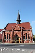
- Historic churches: Church of the Assumption, Exaltation of the Holy Cross church
- Zalew Polanowski (artificial lake)
- Historical watermill complex
-
 Church of the Assumption
 -
 Exaltation of the Holy Cross church
 -
 Zalew Polanowski


Demographics edit
| Year | Pop. | ±% |
|---|---|---|
| 1890 | 2,272 | — |
| 1910 | 2,750 | +21.0% |
| 1939 | 3,629 | +32.0% |
| 1950 | 1,310 | −63.9% |
| 1960 | 1,996 | +52.4% |
| 2010 | 2,917 | +46.1% |
| Source: [2][3] | ||
Town twinning edit
Polanów is twinned with:[4]
 Gedern, Germany
- Rothenklempenow, Germany
Notable people edit
- Julius Leopold Pagel (1851–1912), German physician and historian of medicine.
References edit
- ^ a b c "Polanów (zachodniopomorskie)". Polska w liczbach (in Polish). Retrieved 29 October 2019.
- ^ Dokumentacja Geograficzna (in Polish). Vol. 3/4. Warszawa: Instytut Geografii Polskiej Akademii Nauk. 1967. p. 39.
- ^ Stan i struktura ludności oraz ruch naturalny w przekroju terytorialnym w 2010 r. (PDF) (in Polish). Warszawa: Główny Urząd Statystyczny. 2011. p. 109. Archived from the original (PDF) on 13 November 2011.
- ^ "Miasta partnerskie". Polanów.pl (in Polish). Retrieved 29 October 2019.
External links edit
Wikimedia Commons has media related to Polanów.
This West Pomeranian Voivodeship location article is a stub. You can help Wikipedia by expanding it. |