Share

Scan the QR code and open PeakVisor on your phone
Scan the QR code and open PeakVisor on your phone
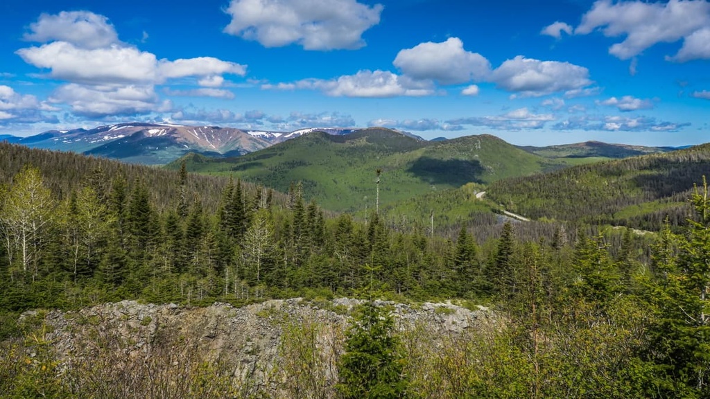
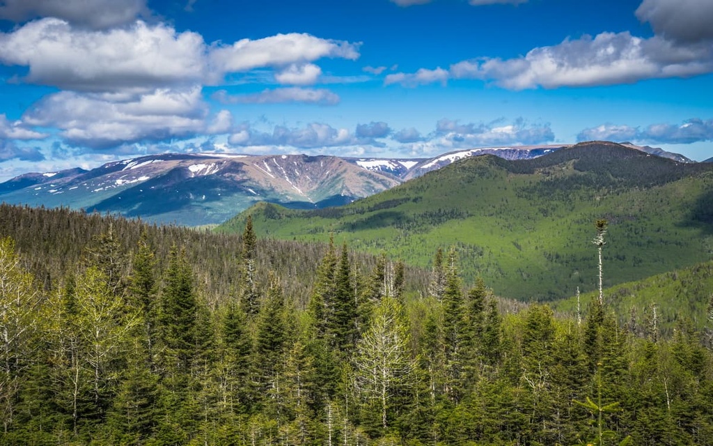
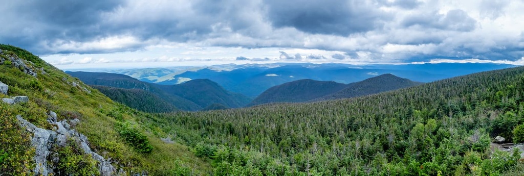
Parc national de la Gaspésie (Gaspésie National Park) is a provincially protected area located in the north-central part of the Gaspé Peninsula (Gaspésie) in the eastern region of the Canadian province of Quebec. The park is known for its dense forests, rugged mountains, and fantastic hiking opportunities. There are 50 named peaks in the park, the highest and most prominent of which is Mont Jacques-Cartier (1,268 m/4,183 ft).

Parc national de la Gaspésie (Gaspésie National Park) is an outdoor recreation area located on the Gaspé Peninsula (Gaspésie) of eastern Quebec in Canada. It is located in the regional county municipalities of La Haute-Gaspésie and La Matanie near the city of Sainte-Anne-des-Monts.
The park is managed by Sépaq (Société des établissements de plein air du Québec/Quebec Outdoor Establishments Company), which is the agency tasked with managing most of the provincially protected parks and wildlife reserves in Quebec.
In total, parc national de la Gaspésie contains 82,000 hectares (202,626 acres) of land in eastern Quebec. It is the sixth largest national park of Quebec after parc national des Pingualuit (Pingualuit National Park), parc marin du Saguenay–Saint-Laurent (Saguenay-St. Lawrence Marine Park), and parc national du Mont-Tremblant (Mont-Tremblant National Park).
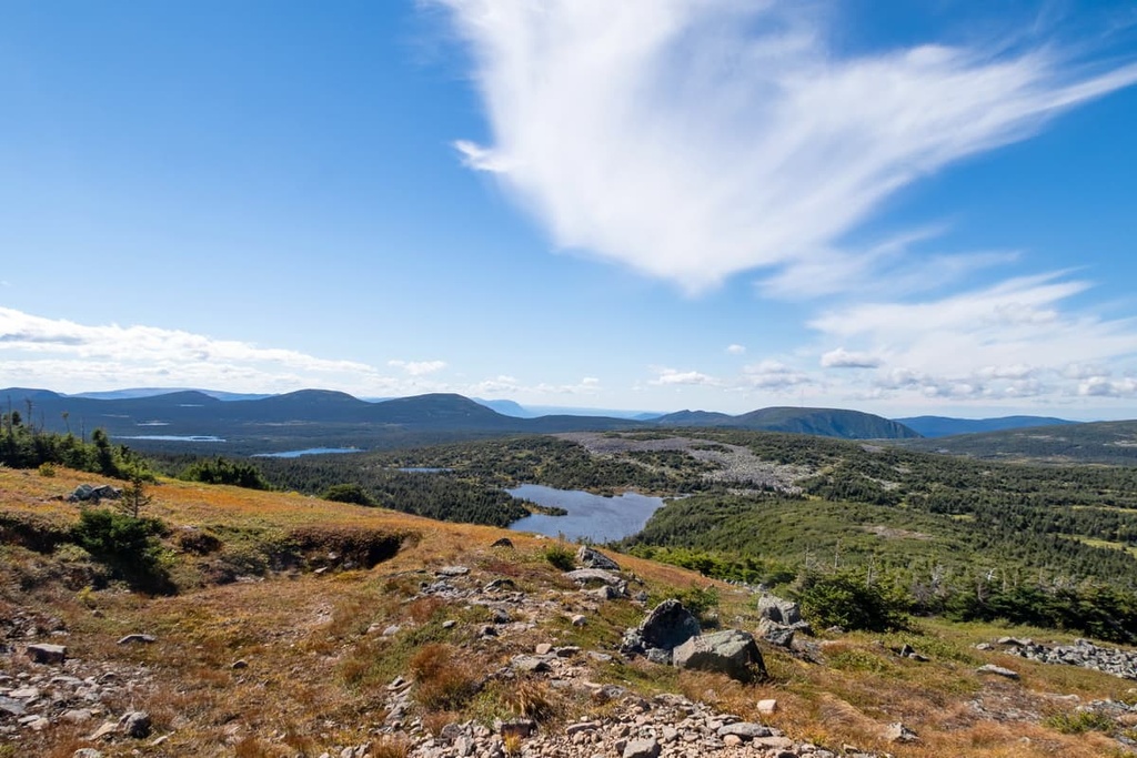
The topography and the climate in the park is varied as it includes everything from the foothills of the Chic-Choc Mountains and the McGerrigle Mountains to the peaks themselves. Additionally, the park’s proximity to the Saint Lawrence River makes it one of the wettest regions of Quebec.
Interestingly, despite the fact that the park is called a “national park” it isn’t actually a federally protected national park.
Rather, parc national de la Gaspésie is a national park of Quebec rather than a national park of Canada. National parks of Quebec are protected under the Loi sur les parcs (Parks Act) of 1977 in Quebec and are primarily managed by Sépaq. National parks of Canada are protected under the Loi sur les parcs nationaux du Canada (Canada National Parks Act) of 2000 and are administered by Parks Canada.
Parc national de la Gaspésie is located in one of the most beautiful and mountainous regions of eastern Quebec.
The park is surrounded by other protected areas on its eastern and western flanks. To the east, the park is bordered by the réserve faunique des Chic-Chocs (Chic-Chocs Wildlife Reserve) and to the west, the park is bordered by the réserve faunique de Matane (Matane Wildlife Reserve).

The peaks in parc national de la Gaspésie are part of the Chic-Chocs Mountains (monts Chic-Chocs) and the McGerrigle Mountains (monts McGerrigle), both of which are technically subranges of the Notre Dame Mountains.
The Notre Dame Mountains cover much of the Gaspé Peninsula of Quebec and extend southward toward the US state of Vermont, terminating before the northern end of the Green Mountains.
In fact, the Notre Dame Mountains are part of the Canadian Appalachians which are, in turn, a continuation of the Appalachian Mountains that begin in northern Alabama and end in northern Newfoundland and Labrador.
Geologically, the rocks in the park began to form during the Taconic orogeny, which was also responsible for the formation of the Green Mountains. Subsequent mountain building events, such as the Acadian orogeny also helped shape the region into the landforms that we see today.
Granitic intrusions are present throughout eastern Quebec, particularly in the Gaspé Peninsula. These intrusions are the result of a number of events, including a volcanic island arc that once existed in the area. The collision of the microcontinent of Avalonia with the continental craton Laurentia also helped create many of these igneous intrusions.

Indeed, the rocks underlying much of the park are both volcanic and sedimentary in origin. Some of these rocks are up to 600 million years old and many of them formed as a result of underwater volcanic activity in the region, especially in the Chic-Chocs. As far as the McGerrigle Mountains go, these peaks are actually the result of a large igneous intrusion of granite that formed about 380 million years ago.
That said, the geologic activity that’s arguably most responsible for carving out the landscape of the park that we see today was the Pleistocene glaciation. Millennia of glacial cover during the Pleistocene helped to cave out the region’s valleys and smooth over much of the park’s peaks.
While there aren’t any glaciers left in parc national de la Gaspésie today, the park is known for getting more snowfall than nearly anywhere else in Quebec. If you’re lucky, you may even see snow on some of the park’s highest peaks during the early summer months.
Major peaks in the park include Mont Jacques-Cartier (the highest peak in southern Quebec and the Canadian Appalachians), Mont Dos-de-Baleine, Mont Richardson, Sommet Albert Sud, Mont Logan, Mont Arthur-Allen, and Les Cônes.
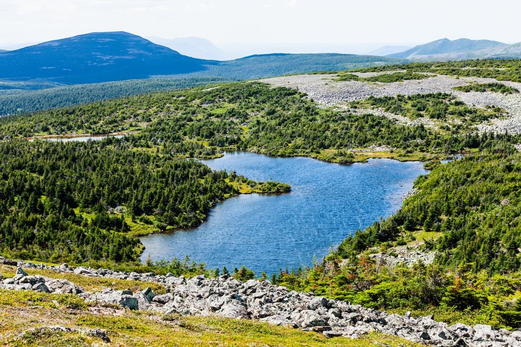
Parc national de la Gaspésie boasts a varied ecology thanks to the region’s diversity of topographies and climates.
Much of the park is dominated by the Gaspésian massif. The massif’s tall prominence over the low-lying terrain below and its proximity to the Gulf of Saint Lawrence provides it with a unique ecology that’s hard to find elsewhere.
Around the summit of the park’s tallest peak, Mont Jacques-Cartier, the average annual temperature is around -2.5ºC (27.5ºF). Throughout the year, the massif gets a large amount of moisture. During the summer, this moisture falls as rain and the region receives some of the highest annual rainfall in Quebec. It also gets more snow than nearly anywhere else in the province.

Additionally, the Gaspésian massif is known for its howling winds. The average wind speed is around 24 km/h (15 mph/6.7 m/s) on Mont Albert but gusts as fast as 250 km/h (155 mph/69 m/s) have also been recorded in the region.
All of these climatic features combined give the park a unique ecology that’s dominated by a large alpine zone throughout the massif. The summits of most of the tallest peaks in the park are bare of trees as they feature only smaller shrubs and flowers. At lower elevations, the park also features forests of balsam, fir, and white burch.
Furthermore, parc national de la Gaspésie is home to one of the last remaining herds of woodland caribou found to the south of the Saint Lawrence River. These caribou are heavily protected but, if you’re lucky, you may get to see some of them wandering around the park during your visit.
Other animal species found in the park include a plethora of fish. Speckled trout, lake trout, Arctic char, and even Atlantic salmon can all be found in the park’s waterways.
The park is no slouch when it comes to bird life, either. Some species that you could see in the region include the white-thorated sparrow, horned lark, Bicknell’s thrush, harlequin duck, and golden eagle.

The land that is now part of parc national de la Gaspésie has been home to humans since time immemorial. In particular, the park is located on the traditional territory of the Mi'kmaq First Nations, whose ancestral homelands include much of what is now eastern Canada including the Gaspé Peninsula.
The first peoples of European descent to visit the greater Gaspé region were members of Frenchman Jacques Cartier’s expedition. Cartier’s expedition landed in what is now called Gaspé in 1534, however, French colonization of the region didn’t begin in earnest until the arrival of Samuel de Champlain at what is now Quebec City in 1608.
French colonial settlements around what is now the national park started forming around the late eighteenth to early nineteenth centuries. Some settlers arrived in the area of what is now Sainte-Anne-des-Monts in 1815, primarily as a result of the region’s good fishing opportunities.
During the mid to late nineteenth century, geologists such as Sir William E Logan and Alexandre Murray led expeditions to the Chic-Chocs to learn more about the area. After summiting the peak on August 26, 1845, Murray gave Mont Albert its current French language name in honor of Prince Albert, the consort of Queen Victoria, whose birthday was that day.
In the early 1920s, miners discovered copper ore in the area around what is now Murdochville, just to the east of the current park boundaries. This brought a minor influx of settlers to the region, though mining didn’t begin on a major scale until the 1950s.
Throughout the early to mid twentieth century, the region around what is now parc national de la Gaspésie became more popular among visitors. That said, during World War II, the Canadian Army occupied the summit of Mont Jacques-Cartier in order to protect the region from foreign attackers.

The park’s now-famous Gîte du Mont-Albert first opened to the public in 1950, heralding in a new age of tourism in the region. With the passage of the 1977 Loi sur les parcs (Parks Act) in Quebec, the stage was also set for the establishment of protected areas throughout the province.
Parc national de la Gaspésie was officially established on November 25, 1981. It was placed under the management of Sépaq, which administers most of Quebec’s provincially protected areas. The park’s visitor center opened in 1986 and the park is now one of the Peninsula’s most popular tourist destinations.
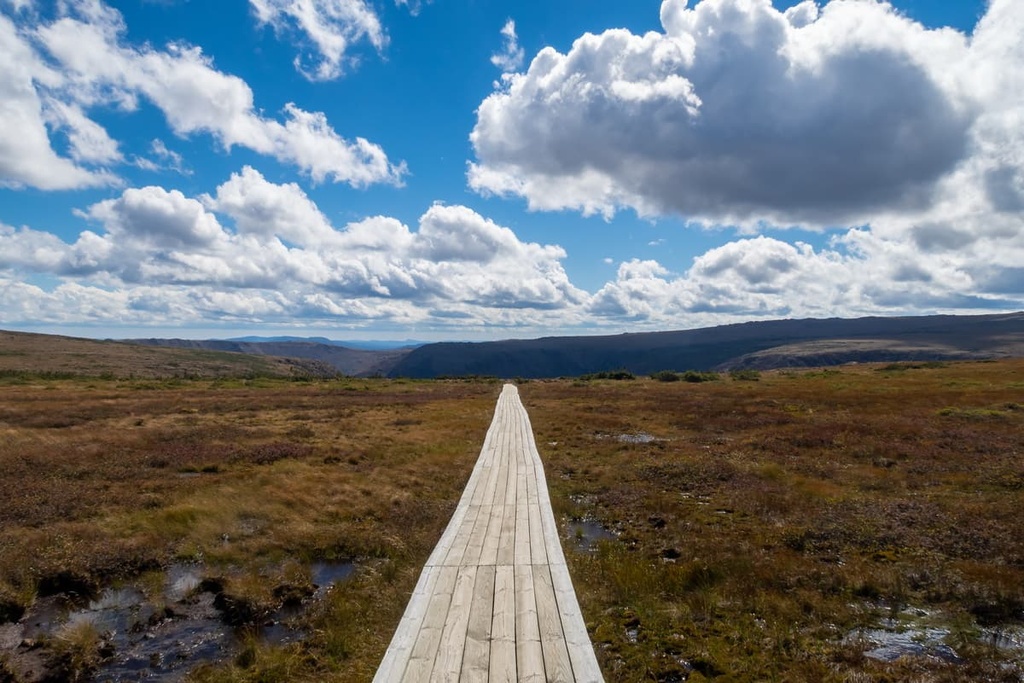
There are dozens of hiking trails in parc national de la Gaspésie for visitors to enjoy. Some of the most popular day hikes include:

Due to the fragile and unique nature of the park, visitors are only allowed to backpack on certain established trails. These trails, which are known as “compulsory circuits” are of varying lengths and difficulties.
There are multiple circuits available, depending on the season. You can choose to bring a tent (these must be pitched on the available platforms) or you can book a stay in the park’s backcountry huts.
For summertime tent camping, two popular circuits include:
The same two circuits are available for summertime hut stays, too, but instead of stopping overnight at tent platforms, you’ll sleep at the many huts located along each circuit. Note that the winter hiking circuits are different from the summer trails and they are all hut-based adventures.
Reservations are required for backpacking trips in the park. Bookings can be made by phone at +1 (800) 665-6527.
Parc national de la Gaspésie is a truly spectacular place and any visit to the park is sure to be one to remember. But before you leave home, there are a few things you ought to know about visiting the park.
First and foremost, keep in mind that, like most national parks of Quebec, entrance to Gaspésie isn’t free. You can either buy an Annual Park Card for Gaspésie National Park or you can buy an unlimited pass to all the province’s national parks.
Alternatively, you can purchase a daily access pass, but these are charged at a per-person rate for adults over the age of 18. You can check the park’s current entrance fees for the most up-to-date information.

Gaspésie National Park is located in a remote part of eastern Quebec. There is good road access to the park via Quebec Route 299, which traverses the park from north to south.
If you’re coming from the north via Saint-Anne-des-Monts, the best place to stock up on provisions and gasoline is in the city itself. There are few other services available as you get closer to the park.
The national park is home to a number of visitor and registration centers, most of which offer information, basic food items, basic first-aid, washroom facilities, rental equipment, and firewood for sale. These visitor and registration centers include:
Note that most of the visitors centers are only open during standard business hours (e.g., 9 am to 5 pm), but some may close slightly earlier or later depending on the season.
Visitors to parc national de la Gaspésie that want to spend the night in the park have many different options to choose from. Here are some of the most popular accommodation options to check out in the park before your next visit.
For visitors that want to set off on an extended adventure, the park’s many backcountry tent sites and huts are well worth checking out.
In parc national de la Gaspésie, dispersed camping is not allowed. All visitors to the park who want to spend the night in the backcountry need to use a tent platform or a backpacking hut. There are a number of huts and dedicated tent platforms available along the most popular hiking and skiing routes in the park.
The tent platforms (also called rustic campsites) are located in secluded areas and are available by phone reservation only (+1 800-665-6527). These platforms have a pit toilet nearby, too.
As far as huts go, here are 11 backpacking huts in the park that you can only access on foot. These huts are simple and rustic, so you’ll still need to bring a sleeping bag, food, and other supplies.

There are 4 serviced campgrounds located throughout the most popular areas in parc national de la Gaspésie. These campgrounds include:
In addition to these campgrounds, which offer both tent and RV camping, there is a dedicated RV area at the La Vallée RV site. This site is designed for RV campers and motorhomes, but it’s best for visitors who are self-sufficient. There are washroom facilities available, but they’re at least 500–1,500 m away from the campsites.
Parc national de la Gaspésie is home to an impressive array of equipped cabins and huts in addition to the more rustic huts available for backcountry travel.
Near the Gîte du Mont-Albert, the park has 18 year-round cabins and 5 summer-only cabins that provide a luxurious outdoor getaway. There are also 4 year-round cabins along the shores of Lac Cascapédia and 4 winter-only cabins at Petit-Saut. Note that the Petit-Saut cabins require you to ski along a 4 km (2.5 mi) long trail. You can book all of these cabins online.
Additionally, there are 7 other huts located near the Mont-Albert Campground that offer a more luxurious experience. These huts feature beds, tables, chairs, and wood stoves. They also have washroom facilities nearby. Two other huts located at Arlequin and La Buse are available, too, and they have both a fridge and an electric stove for added convenience.

Ready-to-camp sites are a type of glamping option for visitors to the park that want to spend their nights outside but with minimal hassle.
There’s a total of 20 ready-to-camp sites in the park, all of which are located at the Mont-Albert Campground. Each of these campsites includes a large canvas tent, an outdoor two-burner stove, food prep equipment, a refrigerator, and beds.
You can book all ready-to-camp sites in the park on the Sépaq website.
Gîte du Mont-Albert is a luxury 4-star hotel and resort complex located in the heart of parc national de la Gaspésie. It offers an upscale alternative to camping for visitors that want to enjoy the wilderness during the daytime and retreat to a warm bed with other creature comforts at night.
The hotel itself offers 48 rooms for visitors to enjoy. There are also 12 extra rooms at the Caribou Lodge, which is located just behind the hotel. All of the rooms at the lodge and hotel are designed to have a view of Mont Albert. Each room also has an en-suite bathroom, free Wi-Fi, a fridge, and free coffee.
In addition to the hotel and lodge, the Gîte du Mont-Albert features 15 luxury chalets. These chalets have fully-equipped kitchens, space for 2 to 8 people, Wi-Fi, indoor bathrooms, and a luxurious living room with a fireplace.
Reservations for the hotel and the chalets can be made on the Sépaq website.

Looking for a palace to stay near parc national de la Gaspésie? Here are some of the best cities and towns nearby to check out:
The city of Sainte-Anne-des-Monts is situated on the coast of the Saint Lawrence River, just to the north of parc national de la Gaspésie. It is home to about 7,000 residents, making it one of the largest communities in the east-central part of the peninsula.
Tourism is one of Sainte-Anne-des-Monts’ primary economic activities, as is fishing. The city is one of the most popular starting points for visits to the national park and to the rest of the Chic-Choc Mountains. Additionally, Sainte-Anne-des-Monts is home to a small aquarium (the Exploramer Aquarium) that’s worth checking out.
Sainte-Anne-des-Monts is located along Quebec Route 132, which encircles the Gaspé Peninsula and runs down the coast of the Saint Lawrence before crossing the US border into New York. The city is just over 5 hours by car from Quebec City via Quebec Route 132 and Autoroute 20.

Murdochville is a small town of approximately 800 people located just to the east of parc national de la Gaspésie. Interestingly, Murdochville is one of the only inland towns on the Gaspé Peninsula as most of the region’s communities are located along the coast.
The community of Murdochville was founded as a result of a local copper ore discovery in the 1920s. Although the mine closed in the late 1990s, the town has since tried to diversify its economy through ski tourism and renewable energy production.
Murdochville is accessible via Quebec Route 198, which traverses the northern part of the Gaspé Peninsula. The town is also home to a few hotels, restaurants, and shops that cater to tourists. You can also get gasoline and groceries in town if you need to refuel during your adventure.
With a population of around 50,000 people, Rimouski is one of the largest cities in Quebec that’s located more than 3 hours by road from either Montreal or Quebec City. Rimouski is situated along the coast of the Saint Lawrence River, about a 2–3 hour drive from parc national de la Gaspésie.
Rimouski was founded in the late seventeenth century. Its main economic drivers are tourism, health care, shipping, sports, and transportation. The city is home to the Rimouski Océanic QMJHL ice hockey team and it hosts the Festi Jazz International festival each year.

The capital of Quebec and one of Canada’s largest cities, Quebec City (Ville de Québec) is a major metropolitan area located a half a day’s drive to the southwest of parc national de la Gaspésie.
Quebec City was formally founded in 1608, though it’s been home to many First Nations for countless generations. In fact, it is one of the oldest European cities in North America. The city’s Old Quebec (Vieux-Québec) district is home to the only remaining fortified city walls in North America to the north of Mexico.
Since Quebec City has an international airport, it’s a good starting point for many journeys in the province. However, the city is an excellent destination in its own right, especially if you enjoy culture, history, and great food.


Explore Parc national de la Gaspésie with the PeakVisor 3D Map and identify its summits.