
Order Total (1 Item Items):
Shipping Destination:

Books, Sultan (Over 4,100 results)
Skip to main search results
Product Type Clear
- All Product Types
- Books (4,146)
- Magazines & Periodicals (1)
- Comics (22)
- Sheet Music (3)
- Art, Prints & Posters (350)
- Photographs (20)
- Maps (34)
-
Manuscripts &
Paper Collectibles (831)
Condition
Binding
Collectible Attributes
- First Edition (190)
- Signed (28)
- Dust Jacket (233)
- Seller-Supplied Images (2,991)
- Not Printed On Demand
Free Shipping
Seller Location
Seller Rating
-
A historically important and unique assemblage of three works, including Object A, being the original manuscript of the first modern Ottoman pilot guide to the Red Sea, commissioned by Sultan Abdul Hamid II, it was written by Captain Cemal Bey, who later served as the 'Bahr-i Ahmer Komodoru' (the Commander-in-Chief of the Ottoman Navy in the Red Sea), and was based upon the British Admiralty's 'Red Sea Pilot'; Object B is the extremely rare printed version of the pilot based upon the present manuscript, published in Istanbul in 1891, it is faithful in its content to its antecedent save that it credits Cemal's associate Tevfik Bey as the co-author and is augmented by an additional chapter on navigating the Suez Canal after the writings of Ferdinand de Lesseps, the present example is signed and inscribed in manuscript by Cemal Bey; and Object C, being the very rare second edition of the British Admiralty's 'The Red Sea Pilot', the first modern and comprehensive navigational guide to the Red Sea, and the inspiration for Cemal Bey's work. A. CEMAL BEY (Senior Ottoman Naval Officer). ["Rehber-i Bahr-i Ahmer" / "The Guide to the Red Sea"]. Manuscript, 1889. Small 4� (25 x 17.5 cm): [3], 616 pp. in reverse collation, manuscript, written in Ottoman Turkish in a neat hand in thick black ink; bound in contemporary full red silk with elaborate gilt designs, Ottoman arms to front cover, title within vignette to back cover (Internally clean, crisp and bright, just a few light stains; binding heavily worn but still holding strong); plus 2 additional items found tipped into the back cover: first, is an original photograph of Cemal Bey in naval uniform, measuring 20 x 10.5 cm (irregular size); second is a 'Carte Postale' bearing Cemal Bey's portrait in old age, with a later manuscript inscription, measuring 14 x 9 cm; all housed within a modern custom full dark green calf clamshell box, one panel featuring a glass window, gilt title to spine. [Accompanied by:] B. CEMAL BEY and TEVFIK BEY. [Rehber-i Bahr-i Ahmer / The Guide to the Red Sea]. Istanbul: Istepan Matbaasi, 1307 [1891]. Small 4� (21.5 x 15 cm): vi, 459 pp., [1], in reverse collation, contemporary endpapers; bound in contemporary half-calf with marbled boards, gilt title and decoration to spine; inscribed and signed in manuscript by the co-author Cemal Bey on verso of title (Internally, some light staining and browning especially to early and latter leaves; early leaves creased at upper outer corners, some leaves with trimmed outer corners not affecting text, small tear to upper margin of first leaf with no loss; small tear to lower margin of second leaf with no loss, leaf of pp. 111/2 with horizontal tear entering text with no loss; leaf of pp. 425/6 with tear near gutter entering text but no loss, final leaf creased and torn at gutter with no loss; binding rubbed and worn especially at edges, with loss to upper-outer corner of verso and upper-outer corner of front cover slightly loose, abrasion to front cover). [Accompanied by:] C. HYDROGRAPHIC OFFICE (BRITISH ADMIRALTY). The Red Sea Pilot. From Suez and from 'Akabah to the Straits of Bab-El-Mandeb, and the Arabian Coast thence to 'Aden; with Directions for the Navigation of the Suez Canal. Second Edition. London: George E. Eyre and William Spottiswoode for the Hydrographic Office, Admiralty, 1873. 8� (24 x 15 cm): viii, 255 pp., original light red cloth, gilt title to front cover and spine (Very Good, internally clean and crisp, just some light toning to endpapers, contemporary seller's blindstamp of 'Philip, Son & Nephew' to front endpaper; spine faded). PLEASE SEE OUR WEB PAGE FOR A LONGER DESCRIPTION.
-
Ungarn/Kriegschronik, Ortelius H., anno 1604, 29Portrs.,30 Taf.,
Published by Ortelius Hieronimus, 1524-1614, 1604
Book First Edition
Hardcover. Condition: Gut. 1. Auflage. Ungarn/Kriegschronik, Ortelius H., anno 1604, 29Portrs.,30 Taf., UNGARN - ORTELIUS, H., Chronologia oder historische Beschreibung aller Kriegsemp�rungen unnd belagerungen der St�tt und Vestungen in Ober und Under Ungern mit den T�rcken von A�. 1395 bi� auff gegenwertige Zeit geschehen. Itzund aber von Newem Corrigirt. N�rnberg, Lochner f�r Sibmacher, 1604. 4�. Mit gestoch. Titel, 29 gestoch. Portrs., 30 doppelblattgr. Kupfertafeln und gefalt. Kupferstichkarte. 3 Bl., 581 S. (1 Bl. Errata zwischengeb.), 21 Bl. Mod. Hpgt. mit Rsch. (leicht fleckig, berieben und besto�en). 135. Nebehay-W. 463 (zweite Ausg. 1603). Seltene dritte Ausgabe der umfangreichen Kriegschronik mit Schlacht und Belagerungsansichten zahlreicher ungarischer St�dte in den "T�rkenkriegen. Hier auch die oft fehlende Karte vorhanden; gegen�ber" der zweiten Ausgabe von 1603 um weitere drei Portr�ts vermehrt. Vorderer Vorsatz mit eingeklebtem Katalogtext und Besitzvermerk, Titel bis an den Rand der Darstellung beschnitten und aufgezogen, viele der Ansichten mit Randausbr�chen (meist mit geringem, tls. auch gr��erem Darstellungsverlust) und aufgezogen, einige Ansichten knapp beschnitten, Karte mit Ausschnitten im linken Rand, einige meist restaurierte Randl�suren, S. 577/578 verbunden, etw. braunfl., wasserrandig (auch wenige Tafeln) und gebr�unt. NACHGEB.: DERS., Continuatio De� Hungerischen und Sibenb�rgischen Kriegswesens, Vom 1. Januarj. Anno 1603. bi� auff jetziges 1604. Jar. Ebda. 1604. 1 Bl., 35 S. Erste Ausgabe. Rare third edition of the extensive war chronicle with views of battles and sieges of numerous Hungarian towns during the Turkish wars. Our copy also with the often missing map. Upper endpaper with glued-in catalogue text and ownership entry, title cut up to illustration edge and mounted, many views with breaks in margin (sometimes affecting illustration) and mounted, some views closely trimmed, map with cut-outs at left margin, some tears in margin restored, p. 577/578 misbound, a little brown-stained, waterstained, some browning. Modern half vellum with spine label (slightly soiled, rubbed and scuffed). See illustration. HIERONYMUS ORTELIUS (1524, Augsburg 1614, N�rnberg) Chronologia oder Historische Beschreibung aller Kriegsemp�rungen unnd Belagerungen . so in Ober und Under Ungern auch Sibenb�rgen . geschehen . N�rnberg, Siebmacher, 1603 Aufgeschlagen: Erste Wiener T�rkenbelagerung 1529 Sammlungen des F�rsten von und zu Liechtenstein, Vaduz Wien, Bibliothek: "Im Sommer 1529 zog Sultan S�leyman ( der Pr�chtige"; um 1495-1566) mit einem ungef�hr 150000 Mann z�hlenden Heer gegen Wien. Am 26. September bezog er seine pr�chtige Zeltburg bei Kaiserebersdorf, auf jenem Gel�nde, wo sp�ter das Schloss Neugeb�ude" errichtet wurde. Die Stadt Wien wurde von rund 12000 S�ldnern K�nig Ferdinands (I.; 1503-1564) und 5000 Mann der erst kurz zuvor auf dem Reichstag zu Speyer bewilligten eilenden Reichshilfe" verteidigt. Nach mehreren, f�r die Angreifer sehr verlustreichen Sturmangriffen fiel am 14. Oktober, knapp drei Wochen nach Beginn der Belagerung, im osmanischen Staatsrat die Entscheidung, den Feldzug zu beenden und den R�ckzug nach Konstantinopel anzutreten. HIERONYMUS ORTELIUS Hieronymus Ortelius (Oertl) kam bereits mit f�nfzehn Jahren an den kaiserlichen Hof in Wien, wo er sp�ter die Stelle eines kaiserlichen Hofprokurators und Notars bekleidete. 1580 wurde er wegen seiner aktiven Teilnahme an der protestantischen B�rgerbewegung in Wien zun�chst zum Tode, dann zu ewiger Verbannung verurteilt. Oertl liess sich in der freien Reichsstadt N�rnberg nieder, wo er im Jahr 1614 starb. Bekanntheit erlangte er vor allem als Verfasser der vorliegenden, im 17. und 18. Jahrhundert sehr gesch�tzten ungarischen Kriegschronik". Oertl bietet darin eine umfangreiche Darstellung der T�rkenkri.
-
Picturesque scenery in the kingdom of Mysore.
Published by London, Bulmer f�r Orme, 1805., 1805
Seller: Antiquariat H. Carlsen, Kiel, Germany
Seller Rating:

Mit kolorierter Portr�ttafel in Aquatinta, 40 kolorierten Aquatinta-Tafeln, 3 Blatt (Titel, Widmungsblatt, Tafelverzeichnis) in Querformat, etwas sp�terer Halbledereinband, 56 x 44 cm, Einband etwas berieben, innen unterschiedlich gebr�unt teils etwas stockfleckig, gutes Exemplar. Die sch�nen Aquatinta-Tafeln datiert 1804-1805 mit Ansichten von Seringapatam, Moschee und Grabmal der f�rstlichen Familie, ferner Bangalore, Sriperumbudur, Fort Krishnagiri, Conjeveram, Bankipore u. a., waren urspr�nglich als Teil des gr��eren Werkes A Brief History of Ancient and Modern India (London 1802-1805) entstanden. Das Portr�t zeigt den Feldherrn und Raja Tipu Sultan. Als Vorlagen f�r die Ansichten dienten die Zeichnungen des britischen Offiziers und Milit�rmalers James Hunter (1755-1792), der mit der Royal Artillery im s�dindischen Mysore stationiert war. Seine Arbeiten, die haupts�chlich nach Ende des sogenannten Dritten Mysore-Krieges 1792 entstanden waren, liefern ein umfassendes und lebendiges Bild S�dindiens des 18. Jahrhundert aus europ�ischer Sicht.
-

Schlosser`s Weltgeschichte f�r das deutsche Volk Mit Zugrundelegung der Bearbeitung von Dr. S. L. Kriegk besorgt von Dr. Oscar J�ger und Prof. Dr. Th. Creizenach
Published by Oberhausen und Leipzig, Ad. Spaarmann`sche Verlagsbuchhandlung,, 1870
Book
2. Auflage, 18 B�nde. siehe Beschreibung Die B�nde stammen aus einem Sammlerbestand und werden nur komplett verkauft. Bei Band 1 hat sich der R�ckendeckel gel�st, ansonsten ist der Band in einem sehr guten Zustand. Mit einem Frontispiz von Friedrich Christoph Schlosser. Aus dem Inhalt Band 1: Geschichte der Alten Welt. Orientalische V�lker - Chinesen, Inder, Babylonier und Assyrer, Aegypter, Ph�nicier, Meder und Perser, V�lker der griechisch-r�mischen Zeit, Geschichte der Griechen vom Ende der heroischen Zeit bis zu dem Beginn der Perser-Kriege, Geschichte der Griechen vom Beginn der Perserkriege bis zum Ende des pelopenesischen Krieges, Thebanische Zeit, Die Unterwerfung Griechenlands unter die Oberherrschaft der Macedonier, 537 S., Band 2: V�lker der griechisch-r�mischen Zeit - Fortsetzung - Zeit Alexander`s des Gro�en, Geschichte der letzten griechischen Zeiten, Geschichte der R�mer, Die vorr�mische Zeit Italiens - Die Etrusker, Die Latiner, Die samnitischen V�lker, Die erste Zeit des r�mischen Volkes, Geschichte von Karthago und Sicilien bis zum ersten punischen Kriege, 565 S., 3. Band: V�lker der griechisch-r�mischen Zeit - Fortsetzung, Die Zeit der punischen Krieg, Von dem Auftreten der beiden Grachen bis auf Sullas Tod, Von Sullas Tod bis auf das erste Triumvirat, Von der Bildung des ersten Triumvirats bis zum Untergang der Republik, Litteratur und Bildung der R�mer in der republikanischen Zeit, Die r�mische Kaiserzeit von Augustus bis Hadrian, Die r�mische Kaiserzeit von Hadrians Tod bis auf Constantin den Gro�en, 686 S., 4. Band. Geschichte des Mittelalters - Geschichte der V�lker und Staaten des Ostens, Geschichte der nordischen V�lker in der ersten Zeit des Mittelalters, Geschichte Italiens und der Franken in den ersten Zeiten des Mittelalters, Die Zeit von Karl dem Gro�en bis zum Beginn der Kreuzz�ge, 548 S., 5. Band: Die Zeit von Karl dem Gro�en bis zum Beginn der Kreuzz�ge - Fortsetzung, Die Zeit der fr�nkischen und salischen Kaiser, Das Zeitalter der Kreuzz�ge, Geschichte der vornehmsten Staaten Europas bis gegen die Zeit des dritten Kreuzzuges, Der zweite und dritte Kreuzzug und die damit zusammenh�ngenden Begebenheiten in Deutschland, Italien, England und Frankreich 576 S., 6. Band: Geschichte des Mittelalters - Forsetzung - Die letzten Zeiten des Mittelalters, N�rdliche und �stliche Staaten Europas bis zur Mitte des 14. Jahrhunderts, Frankreich, England, Deutschland und Italien von Albrecht`s I. Tode bis auf Papst Urban V., Spanien und Portugal von dem Untergange der Ommejadenherrschaft bis auf Heinrich von Trastamara, 614 S., 7. Band: �bergang zur Neuzeit. Ausgang des 14. Jahrhunderts, Italien und Deutschland von Urban V. bis auf das Concil zu Pisa, T�rkische und byzantinische Geschichte bis auf die Eroberung von Contantinopel, Deutsche Geschichte bis zur Mitte des 15. Jahrhunderts, Italienische und spanische Geschichte in der ersten Zeit des 15. Jahrhunderts, 524 S., 8. Band - Der Buchr�cken hat sich etwas gel�st, sonst sehr guter Zustand - Fortsetzung �bergang zur Neuzeit, Griechen in Beziehung auf die Bl�the der Wissenschaft in Italien, Deutsche Litteratur im 15. Jahrhundert, Bildung und Litteratur Italiens von Dante`s Tode bis zur Mitte des 15. Jahrhunderts, England und Frankreich im 15. Jahrhundert, Geschichte Burgunds, der Schweiz, Deutschlands und Frankreichs in der zweiten H�lfte des 15. Jahrhunderts, Englische Geschichte von der Schlacht bei Northhampton bis zum Ende des Kampfes der rothen und weisen Rose, Cultur und Litteratur der Deutschen, Italiener und Franzosen in der letzten H�lfte des 15. und in den ersten Jahren des 16. Jahrhunderts, 523 S., 9. Band: Die Hauptstaaten Europas beim Eintritt des 16. Jahrhunderts, Frankreich, Deutschland, Spanien und Italien am Ende des 15. Jahrhunderts und vom Ende des 16. Jahrhunderts bis auf Maximilians I. Tod, Deutsche Angelegenheiten vom Wormser Reichstag bis zum ersten Religionsfrieden (1532), 544 S., 10. Band: Geschichte des 16. Jahrhunderts - Fortsetzung, die T�rken, Ungarn und B�hmen, Heinrich VIII. von England und das deutsche Reich bis zum Ende des Schmalkaldischen Krieges, Deutschland, Frankreich und Spanien bei Abschluss der Reformation und Beginn der Gegenreformation, Philipp II. von Spanien, die Niederland und die franz�sischen Religionskriege bis auf Heinrich III., Sultan Selim II., Frankreich und die Niederlande bis zum Auftreten Alexander`s von Parma, 541 S., 11. Band: Geschichte des 16. Jahrhunderts - Fortsetzung, Deutschland und England am Ende des 16. Jahrhunderts und skandinavische Geschichte bis zu dieser Zeit, Schlussbemerkung �ber die Bildung und Litteratur des 16. Jahrhunderts, Geschichte des 17. Jahrhunderts, Der Drei�igj�hrige Krieg, 544 S., 12. Band: Der R�cken des Bandes ist etwas l�diert, innen ist es in einem sehr guten Zustand - Geschichte des 17. Jahrhunderts - Fortsetzung, Frankreich und Spanien zur Zeit Maria von Medicis und des Kardinals Richelieu, Letzte Zeit des Drei�igj�hrigen Krieges, D�nische und schwedische Revolution, Die englische Revolution von der Errichtung der Republik bis zu Cromwell`s Tode, Niederl�ndische Geschichte von dem 1609 geschlossenen Waffenstillstande bis zum Tode Wilhelm`s II. von Oranien (1650), 13. Band: Geschichte des 17. Jahrhunderts (Schlu�), Frankfreich, Spanien und Italien unter Mazarin, Ersch�tterung der franz�sischen Verfassung, Europa von Mararin`s Tode bis zum Frieden von Nymwegen, Letzte Zeit des 17. Jahrhunderts, Die Litteratur und Geistesbildung des 17. Jahrhunderts in England, Frankreich, Deutschland und den Niederlanden, 558 S., 14. Band: Geschichte der neueren Zeit - Geschichte des 18. Jahrhunderts, Der spanische Erbfolgekrieg, Die Zeit zwischen dem spanischen und �streichischen Erbfolgekrieg, Der �streichische Erbfolgekrieg, Innere Geschichte der europ�ischen Staaten um die Mitte des 18. Jahrhunderts, Die Zeit des siebenj�hrigen Krieges, Bewegungen in der katholischen Kirche und K�mpfe der katholischen Regierungen mit dem Jesuitismus und Papismus, Reformen im Staats.
-
Yeni cografya atlasi / The New Geographic Atlas
Published by Istanbul: Matbaa-I Amire -1309 [1891-1893] (date on the cover), ( maps dated between 1307 and 1311 AH / 1891-1895)., 1307
Seller: Antiquariat Dasa Pahor GbR, M�nchen, Germany
Seller Rating:

Book
Folio, 42 chromolithographed double-paged maps, original chromolithographed illustrated boards, recent black cloth spine, original green endpapers (boards with minor wear, light staining, light water-staining in the lower white margin of the rear cover, tiny chips to the margins of the front cover, spine replaced, crack in the joints repaired, a tiny tear in the Great Britain map). First Lithographed Folio Atlas, Printed in the Ottoman Empire:This fascinating atlas, rare to find in a complete form with original binding in a good condition, was the first lithographed folio atlas in the Muslim world. Published by the Istanbul press Matbaa-i Amire, it is an excellent result of the influence of French cartography on the Ottoman World. The atlas includes the following 42 double-page chromolithographed maps: 1. Solar system, 2. 4 projections of the Earth Globe, 3. Maps of the World, 4. Europe, 5. Asia, 6. Africa, 7. North America, 8. South America, 9. Oceania, 10. Anatolia, 11. The Balkans, 12. Greece, 13. Austro-Hungary, 14. Italy, 15. Iberian Peninsula, 16. European Russia, 17. Germany, 18. France, 19. Switzerland, 20. Scandinavia and Denmark (2 full-page maps), 21. The Netherlands, Belgium and Luxemburg, 22. Great Britain, 23. Persia, Afghanistan, Pakistan, Usbekistan, Tajikistan and Turkmenistan, 24. Russia, 25. China and Korea, 26. Korea and Japan, 27. South-East Asia, 28. India, 29. The Middle East, 30. North-West part of Africa, 31. South part of Africa with Madagascar, 32. Canada, 33. The United States, 34. Central America, 35. The Caribbean, 36. Australia, 37. East part of the Black Sea, 38. The Adriatic Sea, 39. Part od the East Mediterranean with Anatolia and Cyprus on the north and the Nile Delta on the South, 40. West Part of the Black Sea, 41. North Coast of Libya, 42. Levant. (the last 6 maps join in a wall map, embracing the area of eastern Mediterranean and the Black Sea ) The maps are based on the contemporary French cartography. Printed between 1307 and 1311 AH (1891-1895 AD), as dated in the cartouches, the information on the maps does not entirely match neither the index on the back cover (listing only 40 maps) neither the date on the cover 1307-1309 AH (1891-1893 AD), which indicates, that this atlas was a long-term and probably partly improvised project. Maps were possibly also sold separately to raise money, as we have encountered maps from this series which were probably never bound. Ali Seref Pasa The Pioneer of the Modern Ottoman Cartography - The author Ali Seref Pasa (also Hafiz Ali Esref) was a soldier and map-maker, who was sent by the Ottoman government around 1862 to Paris, with a goal to learn the skills of the modern cartography and the technique of modern lithography in colour. In 1869, Ali, when still a student in Paris, published his first atlas, Yeni Atlas or the New Atlas (signed on the maps as Hafiz Ali Esref). This work with 22 maps in folio format, lithographed in bright colours, with decorative Ottoman lettering, is the first modern Ottoman lithographed atlas and together with its printing technique a foundation for all the Ottoman atlases following. Upon his return to Istanbul, Ali Seref Pasa became a chief cartographer at the Matbaa-i Amire, a printing press in Beyazit, which was the successor of the M�teferrika press from 1727. Ali introduced lithograph as a printing technique for cartographic sources to Istanbul and in the following years commissioned a series of maps in folio format, which were issued in another large format atlas (Yeni co?rafya a?lasi / The New Geographic Atlas), making his Paris-based knowledge available in the Ottoman Empire. Ali Seref Pasa s most famous late project was a 100 sheet map of Anatolia, which he based on the Heinrich Kiepert s map of the same area. When Ali died in 1907, the project remained unfinished. Separate sheets of the wall map were sold and today scarcely appear on the market. Ali Seref Pasa or Hafiz Ali Esref - Ali Seref Pasa, who is in our atlas signed in the texts in the cartouches, is possibly identical with another Ottoman cartographer Hafiz Ali Esref, as signed in the Paris published Yeni Atlas. Until the surname law adopted on June 21, 1934 Turks did not have surnames. They were born with one first name and were until the adulthood described only as sons or daughters of their parent s names. Later they were given titles such as Effendi (Sir), Bey (Chief) or Hanim (Madam) for higher classes, or they were given names according to their work or class. The names were not inherited by children until 1934, when the surname law was enforced. The map maker Ali with years received names Seref, the honourable, and Pasa, the dignitary. He was also known as Hafiz, the memorizer of Qur an, and Esref, proud. So Ali Seref Pasa would have a meaning of Honourable Dignitary Ali, and Hafiz Ali Esref, Memorizer of Qur an Proud Ali. (quotation, first published in our catalogue, January 2018). The names Seref and Esref are both based on the same Arabic three letter root. Dar�ttibaa Matbaa-i Amire Printing Press - The first press in the Muslim world, called Dar�ttibaa, was founded in Istanbul by Ibrahim M�teferrika in 1727, with a permission of Sultan Ahmet III. It was located in M�teferrika s house. The first book was published in 1729 and until 1742 sixteen other works followed. After M�teferrika s death the press was suppressed for printing, as printed books were considered dangerous. In 1796 the press was purchased by the government and moved to �sk�dar in Istanbul, and in 1831 finally to Beyazit, where it was renamed to Matbaa-i Amire in 1866. The press was closed in 1901 and was reopened in 1908 under the name Milli. In 1927 the name changed to State Printing House. The press still exists and is known for publishing school and educational books. Note on Rarity - As maps from this atlas appear on the market, examples of the atlas with complete set of 40 maps and a cover in a good condition are exceedingly rare.
-
Allgemeine Zeitschrift f�r Psychiatrie und psychisch-gerichtliche Medicin, hrsg. v. Deutschlands Irren�rzten, unter d. Mit-Redaction v. Damerow, Flemming u. Roller durch H. Laehr. Bd. 5 H. 4, 6 H. 2, 15-16, 20, 22, 25, 27-30, 32, 34-43, 45-52, 54-63, 65-121, 122 H. 3/4 u. 123 H. 3/4 u. Register f�r Bd. 61/70 sowie 71/100.
Published by Berlin Hirschwald -1944, 1848
M. zahlr. Taf. u. Portr. Hlwd. u. Ppbde. m. Rsign. St. u. Sign. a. Tit. u. mehr. S. Einbde. teils etwas besch�d. Wenige R�cken fehlen. Rest in einzelnen OBr. Wenige Hefte unaufgeschn., Kanten besto�en u. am Rand teilw. stockfl. Fehlt: v. Bd. 20 d. 3. Suppl.-Heft. Meist mit Literaturheft/Bericht, teils eingebunden, teils separat. Sp�ter erschien dieses separat zusammen f�r 2 oder 3 Bde. Die erste wichtige deutschsprachige Zeitschrift f�r Psychiatrie. Titel ab 1938 (= Bd. 107): Allgemeine Zeitschrift f�r Psychiatrie u. ihre Grenzgebiete. Ab 1871 (= Bd. 27) Vlg. Reimer, ab 1919 (= Bd. 75) Vlg. de Gruyter, ab 1925 hrsg. durch G. Ilberg, ab 1935 hrsg. durch C. Schneider, ab 1928 hrsg. durch H. Roemer. Enth. u.a.: Fischer, F., Die Ohrblutgeschwulst der Seelengest�rten nebst einer Beobachtung der Kopfblutgeschwulst bei einem solchen Kranken (5 H. 4); Heinrich, C.B., Neue Beitr�ge zur Kenntniss der Harnabsonderung bei den Irren (6 H. 2); Richarz, Ueber Verschiedenheit d. Gr�sse d. Pupillen aus centraler Ursache (15); G�ntz, E.W., Der Wahnsinn der Schulkinder, eine neue Art der Seelenst�rungen; Albers, Die Syphilis des Gehirns u. die daraus hervorgehenden Nerven- u. psychischen Leiden (16); G�ntz, Th., Zur Pathologie d. Hirngef�sse bei Irren ; Die Irrengesetze in Frankreich, Genf, D. Niederlanden, England, Norwegen, Belgien u. Schweden (20); Ripping, L.H., Ueber d. Verwachsung d. Gef�sshaut d. Gehirns m. d. Hirnrinde (23); Hagen, Zur Theorie d. Hallucination (25); Reich, R., Ueber acute Seelenst�rung in Gefangenhaft (27); Huppert, Zur Casuistik d. Irreseins in Folge d. Feldzuges v. 1866 (28); Meschede, Fr., Zur Pathologie u. pathologischen Anatomie d. Pyromanie (29); Scholz, Simulirte Geisteskrankheit. Ein psychiatrisches Gutachten (30); Tigges, Reaktion d. Nerven- u. Muskelsystems Geisteskranker gegen Elektrizit�t (31); Claus, Ein Beitrag zur Kritik d. Filehne'schen Theorie d. Cheyne-Stockes'schen Athmungsph�nomens (32); Stark, Zur Morphologie d. Hinterhauptlappens (33); Schlager, Die psychiatrische Begutachtung des Sultans Murad V. u. dessen Thronentzetzung; Nasse, W., �ber den Vervolgungswahnsinn der geistesgest�rten Trinker (34); Hoppe, J.J., Was ist d. menschliche Geist? Empirisch-psychologisch beantwortet (35); Kroemer, Temperaturbeobachtungen b. paralytischen Geisteskranken (36); Schaefer, Ueber d. Wahnsinnsformen beim weiblichen Geschlechte (37); Schlager, Ueber strafgerichtliche Verurtheilung Geisteskranker (38); Sch�le, Chirurgische Erlebnisse b. Geisteskranken (39); Victor, R., �ber Geisteskrankheiten in Folge hoher �usserer Temperatur (40); Hasse, �ber Selbstmord in Irrenanstalten (41); Schlager, L.,�ber Entweichung u. Entweichungsversuche von Geistesgest�rten aus ihren Verpflegungsorten (42); Langreuter, �ber die Unterbringung "geisteskranker Verbrecher" u. "verbrecherischer Geisteskranker" (43); Tigges, Das Gewicht des Gehirns u. seiner Theile bei Geisteskranken (45); Matusch, Der Einfluss des Climacteriums auf Entstehung u. Form des Geistesst�rungen (46); Mispelbaum, F., Ueber Psychosen nach Influenza (47); Willerding, W., Prognose bei Manie (48); Hebold, O., Untersuchungen �ber d. Hypnotismus (49); Kowalewsky, P., Geistesst�rungen bei Syphilis (50); Heilbronner, K., Ueber Krankheitsdauer u. Todesursachen bei d. progressiven Paralyse (51); Kroemer, Beitrag zur Castrationsfrage (52); Frank, Ein Fall von Simulation (54); M�ller, O., Ein Fall von progressiver paralyse bei Mutter u. Kind (55); M�nkem�ller, Psychiatrisches aus d. Zwangserziehungs-Anstalt (56); Heimann, G., Die Todesursachen d. Geisteskranken (57); Ganter, R., Ueber d. T�towiren, nach Untersuchungen bei Geisteskranken (58); Giessler, C.M., Analogien zwischen Zust�nden von Geisteskrankheit u. den Tr�umen normaler Personen (59); Ilberg, G., Das Gewicht des Gehrins u. seiner Theile von 102 an Dementia paralytica verstorbenen m�nnlichen Sachsen (60); Fischer, M., Schwangerschaft u. Diebstahl; Hegar, A., Der Stotterer vor dem Haftrichter (61); Schott, A., Beitrag zur Lehre von der katatonischen Verr�cktheit (62); Behr, A., �ber den Glauben an die Besessenheit (63); Riehm, W., Zur Frage der Simulation von Geisteskrankheit (65); Birnbaum, K., Zur Lehre von den degenerativen Wahnbildungen (66); Stertz, G., �ber Residualwahn bei Alkoholdeliranten (67); N�cke, P., Homosexualit�t u. Psychose (68); Niesel, E.v., �ber die Mechanik der Wahnbildung (69); Kleist, Die Involutionsparanoia (70); Stelzner, H., Die Fr�hsymptome der Schizophrenie in ihren Beziehungen zur Kriminalit�t u. Prostitution der Jugendlichen (71); Kronfeld, A., �ber die logische Stellung der Kriminologie zur Psychopathologie; Suckau, W., Psychosen bei Frauen im Zusammenhang mit dem Kriege (72); Seelert, H., Zur Pathologie des Querulantenwahnes; Siebert, H., Die Psychosen u. Neurosen bei der Bev�lkerung Kurlands (73); Peretti, Von der �bertragung religi�s-�berspannter u. theosophischer Ideen u. von einer Gruppe "wahrer Menschen" (74); Reichardt, M., Hirnschwellung; Stransky, E., Lustmord eines moralisch defekten Sadisten (mit seltenen, mit der Tat in keinem Zusammenhange stehenden epileptischen Anf�llen (75); Kleist, K. u. D. Wi�mann, Zur Psychopathologie der unerlaubten Entfernung u. verwandter Straftaten (76); Schob, �ber psychische St�rungen nach Durchschu� beider Stirnlappen (77); L�w, H., Das Verhalten der K�rpergewichte von Geisteskranken w�hrend der Kriegszeit (78); Schmidt, K., Die Gr�ndung u. weitere Entwicklung der Landesheilanstalt Alt-Scherbitz; Jacobi, W., �ber die Bedeutung des psychischen Traumas f�r die Entstehung u. den Verlauf der Schizophrenie (79); Hoenig, Ch., Die Ableitung der Besonderheiten der Traumpsyche aus einer Zustands�nderung des schlafenden Gehirnes (80); Fischer, W., Der Zahnzustand bei Schwachsinnigen u. Normalen (81); Colla, Denkschrift �ber die Notwendigkeit der Schaffung eines Trinkerf�rsorgegesetzes (82); Persch, R., �ber die erblichen Verh�ltnisse in Psychopathenfamilien (83); Festschrift Kraepelin (84); Rentsch, P., Musik u. Geist.
-
LITHOGRAPH IN GOLD / ALAOUITE DYNASTY, MOROCCO: [Hethe Marsiya Ash-Sharyf . /This is an Elegy for Sharif Moulay Ahmad, the Son of the Late Sultan of Morocco Moulay Abd al-Rahman Sharif ?
Published by [Istanbul]: Bosnawi Hajji Muharrem Efendi, 25 Rabi al-Awwal [1889], 1306
Seller: Antiquariat Dasa Pahor GbR, M�nchen, Germany
Seller Rating:
Book
An elegant pamphlet in Arabic language with an elegy for Ahmad, a son of sultan of Morocco Abd al-Rahman from the Alaouite dynasty, was lithographed in gold in Istanbul. 8�. 12 pp., original wrappers with lettering, all pages lithographed in gold, elegant modern calf with debossed ornaments to contemporary style, bound with old marbled wrappers, modern yellow endpaper (three tiny worm-holes in white margins of all pages, binding with minor scratches, overall in a good condition An elegant pamphlet, entirely lithographed in gold, contains an elegy for Ahmad Ibn Abd al-Rahman, a son of the sultan of Morocco Abd al-Rahman (1778 1859), who governed from 1822 to 1859 and was known for his reign in the time of the French colonisation of Morocco. Ahmad Ibn Abd al-Rahman was from the Alaouite dynasty, the Arab ruling family of Morocco, which claims descent from a relative of prophet Muhammad. The text was revised by a higher official, a honourable Omar Bin Mohammed Bin Zine al-Abdine and recited by a scholar Mustafa al-Shanini al-Tarabulsi. The author and revisor of the printed text was Ahmed Tahir Al-Kanwi an-Naqshbandi al-Ahmadi al-Mujaddadi al-Sakin from the madrasa at the Bayezid Mosque. The book was lithographed by Bosnawi Hajji Efendi, a printer of Bosnian origins in Istanbul. The subject and an elaborate expensive technique of lithograph in gold on highly surface-sized and burnished paper, imitating manuscripts, suggests that the pamphlet was commissioned privately in small amouossibly as gifts, commemorating sharif moulay Ahmad Ibn Abd al-Rahman. We could not find any other examples on the market nor in institutions. References: N/A No Records Tra.
-
Nouveau plan de Constantinople et des environs
Published by Publisher: Istanbul: Librairie S.H. Weiss. Lithographer: Orell F�ssli & Co, Z�rich. [S. d., but probably circa ]., 1880
Seller: Antiquariat Dasa Pahor GbR, M�nchen, Germany
Seller Rating:
Chromolithographed map, originally dissected in 15 segments and mounted on paper, 63 x 73 cm (24.8 x 28.7 inches), folded in original illustrated cromolithographed wrappers 8� (Slightly age-toned, minor chips to the edges of segments, sporadic annotations in pencil, wrappers and spine slightly rubbed, but overall in a good condition). ISTANBUL: A rare and highly decorative folding map of Istanbul marks not only the most known monuments of the city, but also foreign embassies, a telegraph office, French, British and Austrian post office, horse driven tramcars, hospitals and barracks. Three colours of buildings mark various neighborhoods: Muslim (dark red), Christian (brown) and Jewish (yellow). The information showcased on the map suggests, that the map was printed for Western expats in the Ottoman capital. The wrappers are decorated with a charming orientalist title, a view of Istanbul and on the rear cover a view of the publisher s shop on the prominent location on the Grand Rue de Pera. The map is not dated but was probably printed around 1880. It already represents the T�nel subway, which was opened in 1875. The publisher Weiss probably closed his shop in the late 1870s or around 1880. S. H. Weiss A German Publisher in Istanbul - S. H. Weiss was a fine representative of an industrious international book and map dealer, who successfully connected German publishing industry with distribution at the developing Ottoman market. His store in Istanbul were specialized in selling Germany books, maps and stationeries, often printed in Germany or Switzerland exclusively for the Eastern market. The clients were numberless expats, upper class Ottomans and also Sultan himself. Weiss was closely connected with the Leipzig book trade, concentrated around the book fair, and was first employed as the official commission-agent for Koehler Brothers in Istanbul and later, in the 1860 and 1870, shared his first premises with them on 323 Grand Rue de Pera, selling maps, stationaries and foreign literature. In 1870s he was occupying a shop at 477 Grand Rue de Pera, across the street of the Russian Embassy. Later Weiss s store, depicted on our map, was located on a prominent location in the third shop on the left-hand side of the entrance of the Swedish embassy, at 481 Grand Rue de Pera (for details please see sheet 36 of the insurance plan of Istanbul by Charles E. Goad from 1905), today approximately on the location of 237 Istiklal, occupied by Turkish-German Bookstore & Caf�. It is unclear, when S. H. Weiss closed his business, but probably in the late 1870s, as he did not survive the global depression (Gabriele 2018). A Note on Rarity - The map is extremely rare, especially in the West, as it was only sold in Istanbul for a short period of time. We could only trace three institutional examples in Western libraries (Museum of Fine Arts, Boston, Aargauer Kantonsbibliothek, University of Minnesota, Twin Cities). References: OCLC 732277562, 1040270987, 80033612. Cf.: Alberto Gabriele, The Grand Tour and the North-South Axis of the Nineteenth Century Book TradeThe Pan-European Trade of Foreign-Language Editions and the Forces of Incorporation that Reshaped the Industry, M�moires du livre / Studies in Book Culture, Volume 10, no. 1, 2018.
-
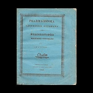
MEDICINE / PHARMACOLOGY: Pharmacopoea Castrensis Ottomana. Pharmacop�e Militaire Ottomane
Published by Istanbul: Henri Cayol ., 1844
Seller: Antiquariat Dasa Pahor GbR, M�nchen, Germany
Seller Rating:
Book
The first printed pharmacopeia in the Ottoman Empire with an original text by an Austrian medical doctor Karl AmbrosBernard, was published by Henri Cayol, the first lithographer in Istanbul. - A uncut example with original wrappers. This is the first printed pharmacopeia, a collection of formulas for medical use, with an original text in the Ottoman Empire. The text is divided in four parts: 1. Basic medicaments in alphabetic order, with their pharmaceutical and systematic names and the descriptions of their uses. 2. Composed medicaments in alphabetic order, sorted by their pharmaceutical and chemical denominations and the descriptions of their uses. 3. Medicaments used in hospitals. 4.- Charts with solutions. The text is written in French and Latin and accompanied by Italian terms. In the introduction the author, Karl Ambros Bernard, wrote, that Italian terms are for the army pharmacologists, who would not understand the first two languages. Sporadic expressions are also quoted in a vulgar Turkish. Bernard was hoping to prepare a complete Turkish translation soon. The book was printed for the official use of the Ottoman Army as a part of a project the sultan, to reorganize the structure, based on the European models. The first printed pharmacopeia in Istanbul actually already appeared in 1818 under a Greek title Pharmacopoeia Geniki, but the text was a translation from an Italian work Farmakopoea ad uso degli Speziali, e Medici Moderni della Repubblica Italiana by Dr. Luigi Brugnatelli. Karl AmbrosBernard - The author was an Austrian medical doctor Karl AmbrosBernard (Charles Ambroise Bernard, 1810-1844), who is known as a founder of the modern medical education and pharmacology in the Ottoman Empire and a pioneer of pharmaceutical terms in Ottoman / Turkish language. Bernard was born in Jilemnice(GermanStarkenbach) in today's Czech republic. After finishing the study of medicine, he was send to Bukowina to fight the cholera. In 1838, he moved to Istanbul on the invitation of the sultan Mahmud II. to reorganize the Imperial medical school for the army doctors in Galata based on the principle of the Viennese Josephinum. During his six years in Istanbul Karl AmbrosBernard became a pioneer of the modern pharmacology and medical education in Istanbul. He published four medical books, one of which he translated to Ottoman, using new medical terminology. In 1844, Bernard published his most famous and influential book, Pharmacopoea Castrensis Ottomana, which he, according to the introduction from September 16th, intended to translate into Turkish soon. Bernard died suddenly a month later at the age of 34 and was buried in Istanbul on November 2nd, 1844. Today a memorial plate on the gate to the Catholic Church SaintMary Draperis on IstiklalAvenue in Istanbulcommemorates this ingenious medical doctor. The book was published in the time of the reforms and modernization of the Ottoman Army on the European examples. It was printed by a French printer and publisher Henri Cayol, who in 1831 opened the first lithographic institute in Istanbul, again as a part of the reorganisation of the army. Henry Cayol the First Lithographer of Istanbul - In Istanbul, H�srev Pasha's lithographic press at the Ministry of War from 1831 under the leadership of Henri Cayol, with its first book produced in the same year, was one of the first functional lithographic presses in the Islamic World, after the Bulaq (1822) and Indian presses (1827). The new Pasha's printer and lithographer was Henri Cayol, a lawyer from Marseille, who opened the lithographic press together with his cousin Jacques Cayol. The modern printing equipment was imported from Paris. The lithographic press was running in the building of the Ministry of War from 1831, when they published this first book, titled Nukhbat al-talim [The Elite Education], with 79 charts representing for training the battalions, to 1836, when H�rsev Pasha was removed from the office. During these 5 years, 50 soldiers were trained by Cayol at the press to learn the technique of lithography. In 1836, Henri Cayol, still under H�rsev Pasha's wing, opened a lithographic press near the French Embassy, where he worked until his death from cholera in 1865. Cayol's work was continued by his apprentice Antonije Zelic, a Croatian, born in Brela, Dalmatia in 1820, who moved to Istanbul 1840 for economic reasons. After learning the craft of lithography from his teacher, Zelic opened his own shop in 1855. The lithography in Istanbul was scarce and expensive to make, as the stones had to be imported until 1892, when they discovered appropriate stone south of Istanbul. More common, especially for the religious prints was much cheaper photolithography. This book was printed in letterpress, as Cayol used the lithographed press for the Ottoman caracters only. Note on Rarity - The book is exceedingly rare. Wolrdcat only lists one institutional example (Bibliotheque Nationale de France). References: OCLC 457048002. Selim N�zhet Gercek, T�rk Tas basmaciligi, [Ankara]: Maarif Vekaleti, 1939. Clifford Edmund Bosworth, The Encyclopaedia of Islam, 1989, p. 802. �BL 1815-1950, Bd. 1 (Lfg. 1, 1954), S. 75; Halil Tekiner - Afife Mat - Mert Sandalci, A Concise History of Turkish Pharmacopoeias from 1818 to Present.
-
ARCHIVE: TUGHRA / MILITARIA / CRIMEAN WAR: Archive 15 parts (various formats and sizes see below for d
Published by Various Places, 1, 1854
Seller: Antiquariat Dasa Pahor GbR, M�nchen, Germany
Seller Rating:
Book
A fascinating 15-part archive of original documents from the Crimean War collected by Lieutenant Gabriel Aubaret, subsequently a famous French diplomat in Siam and Vietnam and a senior administrator in Constantinople; highlights include the 'play book' of the French fleet leading up the Siege of Sebastopol and a resplendent manuscript Tughra of Sultan Abd�lmecid I; altogether granting a unique insight into this important conflict. Gabriel Aubaret was a French naval officer, diplomat, linguist, administrator and business leader. He was perhaps most famous for authoring the first French-Vietnamese dictionary and for his dramatic exploits in Vietnam and at the Siamese Court during the period immortalized by the King and I. In the 1880s, he was one of the most consequential figures in Constantinople, as the President of the Ottoman Public Debt Administration (which controlled much of the nation's economy), as well as the syndicate that completed the railroad used by The Orient Express. From 1854 to 1856,nt Aubaret served with the French naval squadron in the Black Sea during the Crimean War (1853-6). This flotilla played major role in the Siege of Sebastopol, an epic 11-month long operation that is considered one of the great classics of military history. The present archive of fifteen original documents, acquired by Aubaret during this period, is highlighted by Admiral Bou�t-Willaumez's original operational 'play book' for the French landing on Crimea; while the most visually impressive piece is the resplendent manuscript Tughra of Sultan Abd�lmecid I, given to Aubaret in recognition of his service. Other documents include a manuscript battle "ordre", as well as papers conferring various assignments, commands and awards upon Aubaret. The archive presents a unique and authentic view into the Crimean War and its era through the eyes of a young lieutenant near the beginning of his career of adventure and high-level diplomacy. 1. [Gabriel Aubaret's Promotion to Lieutenant].Minist�re de s Colondu Personnel. Bureau du Personnel Militaire. August 17, 1854.Printed letter (letterpress), quarto, singed in Mss. (Very Good, old folds). SEE OUR WEB PAGE FOR A LONGER DESCRIPTION.
-
DISTANCE-TIME-ROUTE MAP / OTTOMAN EMPIRE: Imperial Guarded Domain
Published by Istanbul, Rumi Calendar [1893]., 1309
Seller: Antiquariat Dasa Pahor GbR, M�nchen, Germany
Seller Rating:
Colour lithograph (Good, light wear to the folds, light staining), 68 x 96.5 cm (27 x 38 inches). The very first distance-time-route map of the Ottoman Empire, one of the great masterpieces of Hamidian Era thematic cartography, it depicts the entire realm of the Sublime Porte from Albania to Yemen, noting the travel times between hundreds of locations, including various routes of the Hajj; devised by the General Staff of the Ottoman Army and published in Istanbul. - This is a key milestone in the history of Ottoman cartography, being the very first distance-time-route map of the entire Ottoman Empire. Published in Istanbul in 1893, it was produced by the General Staff (Fourth Division) of the Ottoman Army, predicated upon exhaustive highway surveys and itinerary records compiled over recent years. The map captures the scene during the middle of the rule of Sultan Abdul Hamid II (reigned 1876-1909), during which the empire still controlled vast territories in Europe, Asia and Africa, extending from Albania to Yemen and from Libya to the Persian Gulf. The Hamidian Era also marked a period of rapid modernization of the empire, including the creation of macadamized roads (highways), railways and modern ports. It also hailed the rise of highly sophisticated scientific and thematic cartography of the all regions of the realm created by Ottoman subjects, as opposed to Westerners. Importantly, the present example of the map features intriguing manuscript additions, mainly executed during World War I and its wake. The main part of the map encompasses a great area, centred upon Anatolia, but taking in all the core regions of the Ottoman Empire, with its coverage extending from Bosnia, in the northwest, all the way down to Kuwait City and the head of the Persian Gulf, in southwest, and from Crimea and Baku, in the north and east, down to include Lower Egypt in the southwest. The scope is extended by insets that depict the extremities of the empire; in the lower right corner is an inset capturing the western Persian Gulf, including Kuwait, Bahrain, and Qatar; the inset above details the Red Sea, including Hejaz, Asir and Yemen; while the large inset in the lower felt depicts Ottoman Libya, as well as parts of French Tunisia and Algeria. Exclusively employing text in Ottoman Turkish, the map is traversed by hundreds of lines that connect every city and town of importance in the empire, representing the main land travel routes between these centres. Each segment is accompanied by a number that corresponds to the estimated average travel times between the points in hours (assuming travel by foot while marching, or travel with a horse at a slow trot). The travel times in hours roughly correspond to the distance in the Ottoman unit of a firsah (or league), which is equivalent to 5.685 km (3.532 miles). In both the lower right and upper right, the map features charts quantifying the routes between key points. For instance, the map reveals that, on average, it took 18 hours to travel from the Red Sea port of Jeddah to the holy city of Mecca (a journey that would normally be divided into at least two, if not three, days). The present work is the first ever map to display the distances between all significant travel points in the Ottoman Empire, and for this reason it would have been vitally useful for soldiers, merchants and government bureaucrats when planning their itineraries. It was also one of the only maps to give an approximately accurate notion of the times and distance along several of the most important Hajj Routes, including the famous Syrian Hajj Road, being the 1307 km-long route from Damascus to Mecca, which is here measured out on the present map. The route itself is of such great historical significance in that it is under consideration by UNESCO for World Heritage Status, an unusual accolade for an itinerary, as opposed to a single, distinct place. The Present State of the Map and its Additions - This map appears to be published in 1893 or shortly after in different variations. One of our previous catalogue entries described a state with less itinerary information, however, it included a large distance table in the upper right quadrant not present on the other state. This version has inserted additional road connections, possibly made shortly after 1893, printed in red colour with additional key in the upper right corner. Historical Context: Transportation, Modernization and Cartography in the Late Ottoman Empire. SEE OUR WEB PAGE FOR A LONGER DESCRIPTION.
-
Muharebat-i meshure-i osmaniye alb�m� [Album of Famous Ottoman Battles]
Published by Istanbul : Necmi Istakbal Matbaasi, [1916]., 1332
Seller: Antiquariat Dasa Pahor GbR, M�nchen, Germany
Seller Rating:
Book
Folio. Title page, 33 unbound double page maps, partly printed in colours, with text, 5 single page maps, partly printed in colour, with text, original green wrappers with lettering (maps printed on fragile paper with sporadic tiny cracks and holes, tiny tears and chips in the middle, one map split in the middle fold, wrappers preserved in only fragments, but with no loss to the lettering on the cover). OTTOMAN MILITARY ATLAS: A monumental portfolio of the famous Ottoman battles, edited by a famous military leader Ahmed Muhtar Pacha during WWI to commemorate the glorious military past of the Ottoman Empire - This a rare complete collection of historical military battleplans in Ottoman language in folio size, issued during WWI. The battleplans were first issued separately by the military school between 1903 1907. In 1907, in the year the year Sultan Abdul Hamid was deposed in the Young Turk Revolution, 28 double-page sheets and 3 single-page sheets were gathered and published in an album on the initiative of Ahmed Muhtar Pasha under the title Album of Famous Ottoman Battles (Muharebat-i meshure-i osmaniye alb�m�). The album was republished during WWI as an enlarged portfolio with 38 maps, commemorating the glorious history of Ottoman army, probably to boost up the morality of the Ottoman soldiers. The maps, printed on fragile paper, were loosely inserted in wrappers and almost never survive in a complete set. The maps represent the famous Ottoman battles, mostly on the Balkans: Serbo-Bulgarian War (14 28 November 1885), Battle of Chaldiran (1514), Battle of Breadfield (1479), Siege of Rhodes (1522), movements of the army on the Balkans in 1526, Siege of Szigetvar in 1566, Battle of Mohacs (1526), Second Battle of Mohacs (1687), Battle of Saint Gotthard (1663-1664), Battle of Ni (1689), Fall of Constantinople in 1453, Battle of Bato?ina (1689), Second Battle of Mohacs (1687), Battle of Zenta (1697), Represented are also other famous historical battles, such as the Battle of Nicopolis (1396) and the Siege of Acre of 1799 during the Napoleonic Wars. Ahmed Muhtar Pasha: Scientist, Diplomat, Grand Vizier and War Hero - Ahmed Muhtar Pasha (1839 1919) was one of the most consequential and intriguing figures of the late Ottoman Empire. He was one of the most successful field commanders of his era, as well as a diplomat, politician, and highly respected authority on military technology and related sciences. Ahmed Muhtar was born in Bursa, the son of a successful Turkish merchant. He attended the Ottoman Military College, where he was recognized for his exceptional intellect. Having gained his first field experience during the later days of the Crimean War, in 1862, Ahmed Muhtar led his own detachment in Montenegro, where he played a vital role in defeating the forces of Prince Nikola. Upon his return to Constantinople, Ahmed Muhtar was appointed professor of engineering and artillery at the Ottoman Military College and was sent to France and Germany to learn about the most advanced European weapons systems. Acquiring a profound undertraining of ballistics and metallurgy, for the rest of his life he was a tireless advocate of the modernization of the Ottoman military. He was also involved in raising money for charities in the Constantinople, such that he possessed high level of popularity unusual for military officer. During the same period, he became the tutor to Prince Yusuf Izzedin Effendi, the son of Sultan Abdulaziz, accompanying him on several trips to Europe. SEE OUR WEB PAGE FOR A LONGER DESCRIPTION.
-
Reysen und Bottschafften, welche auff gnedigsten Befelch . Keyser Ferdinandi und Maximiliani II. Der gantzen Christenheit zu h�chsten nutzen gl�cklich vollendet hat. 4 Bl., 536 S. Titel in Rot und Schwarz. Schlichter Pappbd d. 18. Jahrh. (berieben, Kanten teils beschabt).
Published by Frankfurt, Andree Wechsels Erben, 1596., 1596
Seller: Antiquariat Wolfgang Braecklein, Berlin, Germany
Seller Rating:
First Edition
Erste deutsche Ausgabe des bedeutenden Gesandtschaftsberichts in vier Briefen, gesammelt erstmals 1589 in Paris erschienen. Ogier Ghislain de Busbecq (1522 - 1592) war Diplomat in den Diensten der Habsburger in England wie in Spanien. "Im Herbst des Jahres 1554 schickt Ferdinand I. Busbecq als Botschafter zu S�leyman I. nach Konstantinopel, damit er einen Waffenstillstand mit dem Osmanischen Reich aushandele, um das geschw�chte Reich der Habsburger zu entlasten. Busbecq bricht am 23. November 1554 von Wien auf und reist mit seinem Gefolge im Wagen zun�chst nach Buda, von dort auf der Donau nach Belgrad, anschlie�end wieder auf dem Landweg �ber Nisch, Sofia und Adrianopel nach Konstantinopel. Am 20. Januar 1555 in Konstantinopel angekommen, findet Busbecq den Sultan jedoch nicht in seiner Residenz vor. Er erf�hrt, dass sich Sultan Suleiman gerade auf Reisen in Kleinasien befindet, so dass er ihm weit in den Osten, in die alte K�nigsstadt Amasya, nachreisen muss. Nach dreiw�chigem Warten reist Busbecq ihm �ber Ankara hinterher, um schlie�lich am 7. April 1555 in Amasya in einer Audienz mit dem Sultan einen sechsmonatigen Waffenstillstand auszuhandeln. Als er den Sultan endlich antrifft, hat dieser augenscheinlich gerade keine Lust auf Friedensgespr�che und weist ihn mit den Worten 'G�zel, g�zel', 'sch�n, sch�n', ab. Zum Trost schenkt er Busbecq ein paar Tulpen- und Hyazinthenzwiebeln, dazu einige Fliederpfl�nzchen. All dies bringt Busbecq mit nach Hause und f�hrt diese Pflanzen unter Vermittlung seines Freundes Charles de l'�cluse (latin.: Carolus Clusius) dadurch in Westeuropa ein. Auf ihn geht die Bezeichnung der Tulpe (t�rkisch und persisch Lale) als Tulipam zur�ck: anscheinend hatte er den Namen des Turbans (t�rkisch t�lbent), an dem Bl�ten oft getragen wurden, f�r den Namen der Pflanze selbst gehalten" (Wikipedia). Im November 1555 verl�sst Busbeck Wien erneut und bricht wieder nach Konstantinopel auf, wo er bis 1562 f�r sechs Jahre als Botschafter in Konstantinopel wirkt. "His letters contain perhaps the most interesting of all accounts of Turkish life, and his description and analysis of the Ottoman state can hardly be superseded" (Blackmer). Aus der Bibliothek des sachsen-weimarischen Kammerjunkers, Schriftstellers, Agrar�konomen und Gelehrten Georg August von Breitenbauch (1731-1817), mit dessen gestoch. Exlibris. Die letzten drei Blatt mit Loch im wei�en Rand. Vereinzelt zeitgen�ss. Anstreichungen. Gutes und breitrandiges Exemplar. Nur ein Exemplar im JAP seit 1950. VD 16, B 9867; G�llner 2188; Kertbeny 1179.
-
Geschichte des osmanischen Reichs nach seinem Anwachse und Abnehmen. Beschrieben von D.K., ehemaligen F�rsten in Moldau. Nebst den Bildern der t�rkischen Kaiser, die urspr�nglich von den Gem�lden in dem Seraj durch des Sultans Hofmaler sind abgenommen worden. Aus dem Englischen �bersetzt.
Published by Hamburg, Herold,, 1745
Book First Edition
Deutsche Erstausgabe. Mit 23 gest. Portr�ts, 1 gefalt. Plan (Grundri� von Konstantinopel) sowie 10 Textkupfern (1 Titelvignette und 5 Textvignetten). 3 Bll., 64 SS., 852 SS., 1 Bl. VD18 10217568. Lipperheide Lb 30. Blackmer Coll. 281. Graesse II, 38. - Seltene erste deutsche und eindrucksvoll bebilderte Ausgabe. Die Erstausgabe erschien 1734 in London. Das Hauptwerk des ber�hmten Gelehrten, der 1687-1710 als Geisel in Konstantinopel gehalten wurde und f�r seine Verwendung t�rkischer Quellen als einer der vorz�glichsten Mittler zwischen morgen- und abendl�ndischer Literatur gilt. - Enth�lt eine chronologische Geschichte anhand der osmanischen Herrscher von dem Reichsgr�nder Osman I. bis zu Achmed III. (1214-1711). Die Tafeln zeigen 22 sch�ne Ganzk�rperportr�ts der t�rkischen Kaiser sowie 1 Portr�t des Verfassers mit seinem Wappen. Der Faltplan, "Grundri� von Constantinopel", enth�lt einen detailreichen Lageplan des goldenen Horns sowie eine kleine Darstellung des f�rstlichen Palastes von Demetrie Kantemir. Zu Beginn und gegen Ende etwas wasserrandig bzw. leicht fleckig, letztes Blatt mit minimalem Loch (kein Textverlust), Titel gering gebr�unt. Sch�nes Ex. Sprache: Deutsch Gewicht in Gramm: 0 4� (24,5 x 20,5 cm), Halblederband neuerer Zeit auf 5 B�nden mit Goldpr�gung und R�ckenschild in rotem Leder.
-
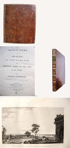
Select views in Mysore,
Published by London, Bowyer, 1794., 1794
Seller: Antiquariat H. Carlsen, Kiel, Germany
Seller Rating:
First Edition
the country of Tippoo Sultan; from drawings taken on the spot; with historical descriptions. Mit 1 doppelblattgro�en kolorierten Kupferkarte, 3 gefalteten gestochenen Pl�nen, 29 Kupfertafeln nach Home. VII, 1 Blatt, 48 Seiten, 13 Blatt in Urdu (mit arabischen Schriftzeichen), Lederband der Zeit mit R�ckenvergoldung und dreiseitigem Goldschnitt, 35 x 28,5 cm, Einband etwas berieben und beschabt, innen leicht gebr�unt, gutes Exemplar. Erste Ausgabe. Die sch�nen Kupfer mit Ansichten von Landschaften, Tempelanlagen, britischen Forts etc. Home war Sch�ler von A. Kauffmann und folgte im 3. Mysorekrieg (1789 bis 1792) den englischen Truppen auf ihrem Feldzug, wo die Skizzen zu vorliegendem Werk entstanden.
-
Devlet-i Aliye-i Osmaniyenin Bin �c Y�z on �c Senesine Mahsus Istatistik-i Umum
Published by Constantinople: (Rumi Calendar), [1900]., 1316
Seller: Antiquariat Dasa Pahor GbR, M�nchen, Germany
Seller Rating:
Book
4� (28 x 21 cm / 11 x 8 inches): Reverse collation - 12 pp., 166 pp. (of which p. 18 is a folding table), plus 1 folding table (between pp. 106-7), plus 8 colour lithograph folding plates (being 6 thematic maps and 2 sets of statistical diagrams, each measuring 37.5 x 47 cm / 15.5 x 18.5 inches), pages gilt-edged; from the library of Sultan Abdul Hamid II, accordingly bound in contemporary red cloth bearing the Sultan's Tughra and elaborate gilt-stamped designs (Good, internally quite clean, just a few minor stains and short tears, old repair to final text page not affecting text; first folding plate a little loose, final folding plate a little stained; neat 1960s former owner's inscription to upper corner of title and stamps to front endpapers; binding a little worn and stained, some worming to front cover, gilding a litt OTTOMAN EMPIRE / THEMATIC CARTOGRAPHY / STATISTICS: The State of the Ottoman Empire based on the 1313 figures of the Public Statistics Authority. From the library of Sultan Abdul Hamid II a very rare and highly important work, being the improved second edition of first book of statistics on the Ottoman Empire; illustrated with ground-breaking thematic maps predicated upon fresh, original data; one of the great landmarks in the era's rapid modernization of Turkey, the Balkans and the Middle East; bound in the sultan's signature red covers, bearing his gilt Tughra. This is an extraordinary, and indeed unique, example of one of the most important works concerning statistics and thematic cartography in the Ottoman Empire. Hailing from the celebrated library of Sultan Abdul Hamid II, the work is bound in the sultan's signature red covers, bearing his Tughra (monogram), along with elaborate design, all in gilt. The work contained is the second, and corrected and improved, edition of the first book on ththe Ottoman Empire, bringing qualitative data on the population, demographics, economy, health, agriculture and expenditures of the entire realm together in a single work for the first time. Importantly, the text is illustrated with ground-breaking thematic maps and graphic charts that are amongst the earliest and most sophisticated works of their kind created in the Muslim world. In the 1890s, the Ottoman Empire was a vast land of over 17 million residents, extending from Albania to Yemen. A realm of great ethnic and economic diversity, beset by many external and internal pressures, despite the best efforts of determined reformers, it was only in 1893 that that the first modern, scientific national census was completed. The newly-formed Ottoman national statistics authority, armed with this data, as well as a vast corpus of quantitative economic information from various government ministries, tabulated the very first comprehensive statistical overview of the Ottoman Empire in 1897. The Ottoman Administration for the Economy and Commercial Affairs (Nezaret-i Umur-i Ticaret ve Nafia) used this grand tableau to produce the first edition of the Devlet-i Aliye-i Osmaniyenin in the Rumi year 1315 (1899), containing 231 pages, plus maps. While an impressive achievement, this work was found to contain some errors and oversights, as well as featuring some data considered superfluous. The present work is a corrected, improved and streamlined edition of the Devlet-i Aliye-i Osmaniyenin, published in the Rumi year 1316 (1900). It consists of dozens of statistical tables revealing the figures for a wide variety factors concerning the Ottoman people, as well as the national and regional economies. Importantly, the book features 6 advanced thematic maps showcasing the national infrastructure system; the demographic make-up of the each vilayet (province); as well as economic measurements. The maps are amongst the earliest and most sophisticated thematic maps produced in the Ottoman Empire, and they succeeded in bringing the work in line with the best practices employed in nations such as France and Germany. Further editions followed, as new data became available, until the advent of World War I. SEE OUR WEB PAGE FOR A LONGER DESCRIPTION.
-
Ottoman Manuscript on Shipbuilding
Published by [S. n., S. d., but prob. Istanbul, late 19th century].
Seller: Antiquariat Dasa Pahor GbR, M�nchen, Germany
Seller Rating:
Book
Small 4�, [64 pp.] manuscript in black ink with annotations in pencil, drawings in pancil and water-colours, unbound (minor staining and folds in corners, some pages loose, but otherwise in a good condition). A unfinished unique manuscript by an anonymous author with eye-catching vignette and drawings is a late 19th century Ottoman translation of a British, German or French work on ship-building. According to the introduction it was commissioned by sultan, possibly as a project of the modernization of the army and the navy, which started with the Tanzimat just before the middle of the 19th centuy. The translations in the late Ottoman empire were of high significance, as they brought first-hand information from the West to mostly Muslim controlled country and press. They were highly influential for the further development of knowledge and researches. We could not establish, if the translation was ever finished or printed.
-
Patmut'iwn mardkayin patuastman / History of Human Vaccination
Published by Istanbul: Tpagrowtiwn Aramean, ., 1884
Seller: Antiquariat Dasa Pahor GbR, M�nchen, Germany
Seller Rating:
Book
4�: [2 pp.], portrait, [16pp.], 237 pp., with interleaved plates on card (2 original photographs, one black and white xylographic print, with a dedication and signature by the author in Armenian), later marbled paper wrappers with mounted original illustrated cover (first pages brittle in margins with partly restored chips and tears and remounted in gutters, small worm holes, otherwise in good and clean condition with sporadic soft folds to corners). An exceedingly rare, detailed book on the history and importance of vaccines written by a prominent Ottoman Armenian doctor Dikran Pasa Pestemalciyan, published on the eve of the Sublime Porte s decree on the mandatory application of the smallpox vaccine. This rare and important book in the Armenian language was written in Istanbul by the prominent medical doctor Dikran Pasa Pestemalciyan. It describes the importance of vaccines, their history and includes images of historical inoculation campaigns of children, medical tools for vaccination and a drawing of skin reaction to a vaccine. The book commences with a portrait of Edward Jenner (1749 - 1823), a British scientist who also pioneered the concept of vaccines, and notably created the smallpox vaccine. It was issued in 1884, a year before the Ottoman Empire issued a decree on mandatory smallpox vaccination, the first such state legislation in world history. The present example is dedicated in manuscript by the author. Dikran Pestemalciyan was born to a prominent Armenian family in Hask�y, Istanbul. After graduating high school in his city, he science science, and later medicine, in Paris, where he completed his doctoral thesis in 1867. Dikran returned to Istanbul two years later, where he became a member of the Imperial Medical Association (Cemiyet-i Tibbiye-i Sahane, or Soci�t� Imp�riale de M�decine), of which he served as chairman between 1877 and 1878. From 1880 and 1881, he was the director of the Yedikule Surp Pirgic Armenian Hospital and in 1884 became the medical undersecretary of Sultan Abdul Hamid II. That same year, he was elected a member of the Soci�t� Francaise d'Hygi�ne. Dikran also played a vital role in the connection between the Red Cross and Red Crescent. In 1892, he was promoted to the rank of Pasa. Dikran Pasa authored several important medical works, such as articles on colon cancer, vaccines, hygiene and prostitution, as well as three printed books; two pamphlets on hygiene and childcare and a book on the history of vaccines (the present work). The present work is very rare. Worldcat lists only 2 examples (British Library and the Library of Congress). Our collation features a portrait and 6 plates, what is one more than the example held by the British Library. The examples listed in Worldcat record only 3 plates. The examples listed in Worldcat record only 3 plates. References: OCLC 38485434. Cf. Kevork Pamukcuyan, �l�m�n�n Y�z�nc� Yilinda Hilal - i Ahmer Kurucusu Dr. Dikran Pasa, Tarih ve Toplum, 134, 1995.
-
Mevkufat also M�lteka terc�mesi. Mevkufati or Mevkufati. M�lteka tercu?mesi
Published by Bulaq: 15th day of Safar (1837/38), 1254
Seller: Antiquariat Dasa Pahor GbR, M�nchen, Germany
Seller Rating:
Book
2 volumes in 1. Large 4�, 2 pp., 356 pp., 2 pp., 314 pp., original calf binding with a flap and debossed ornaments, modern black spine. Margins of the first pages lightly dusty with tiny tears, old taxation stamp on the first page of the index, small wormholes in the lower white margin throughout the book, one page with partial loss of the upper margin (paper deformation as originally published), sporadic old annotations in margins, minor staining in margins, sporadic pages lightly stained in the text, repaired tear in one white corner, two repaired tears in text with acid-free partly transparent tape, index of the second part with tiny holes (paper deformation as originally published), pp. 41-44 of the second volume mispaginated as pp. 45-48, last quarter with some small wormholes in the text, but overall inside in a good condition without major damages to the paper. Later endpapers, spine repaired with later black calf, binding slightly scuffed and with small worm holes. BULAQ IMPRINT - ISLAMIC LAW - MULTAQA: The first printed edition of the most important text on the Islamic law in the Ottoman Empire. The original Arabic text, of what was to become the most important law text of the Ottoman Empire, titled Multaqa al-Abhur (Confluence of the Seas) was written by a late 15th and 16th century Hanafi scholar Ibrahim al-Halabi. It was translated an annotated by Mehmet Efendi (died 1065 AH / ca 1648 AD), who gained his nickname Mevkufati for his work on the field of the law (wakf). The text discusses various fields of the law, Islamic law and also delas with issues such as alcohol consume and hermaphrodites. The text, usually known as Multaq? (or M�lteka Terc�mesi in Turkish), written in 923 AH or 1519 AD, soon gained an immense popularity under sultan Suleyman the Magnificent (reigned 1520-1566), who was called by the Ottomans Suleiman Kanuni or "The Lawgiver". The text, which "presents Islamic law in its final, fully developed form" (Joseph Schacht, An Introduction to Islamic law, 1964, p. 112) became one of the most influential legislative texts of the Ottoman Empire. In 1876, James Lewis Farlex observed in his work Turks and Christians: "The Sultan rules over the Turks, but the Koran and the Multeka rule over Sultan". The book includes the following chapters: ritual purity, ritual prayer, alms tax, fasting, pilgrimage to Mecca, marriage, fosterage, repudiation, manumission of slaves, oaths, the fixed punishments, theft, the conduct of war, foundlings, found property, runaway slaves, missing persons, partnership, religious endowments, sales, exchange, suretyship, transfer of debts, administration of law, testimony, procuration, claims, acknowledgements, amicable settlements, sleeping partnerships, deposits, loans, gifts, hire and lease, slaves who have concluded a contract of manumission, relationship of client and patron, duress, interdiction, slaves who have been given permission to trade, usurpation, pre-emption, division, lease of a field, lease of a plantation, ritual slaughter, sacrifice, reprehensibility, cultivating of waste land, unlawful drinks, hunting, pawning, crimes against persons, blood money, bequests, hermaphrodites and inheritance. This is the first printed edition. The second edition was printed two years later, in 1256 (1840/41 AD), and the original Arabic version was printed by the same press in Bulaq in 1263 AH ( 1846/47 AD) (see: Hsu Cheng Hsiang, The First Years of Arabic Printing in Egypt 1238-1269. 1822-1851. The Checklist; no. 281). The test is still published today under the title Mavkufat. M�lteka Terc�mesi and is considered the basis of the Islamic law. Worldcat lists one institutional example (Bogazici University Library). References: OCLC 949546528. Hsu Cheng Hsiang, The First Years of Arabic Printing in Egypt 1238-1269. 1822-1851. The Checklist; no. 259 Edn1.).
-
Navigations Karte Der Donau von Semlin an bis zu ihrem Ausfluss ins Schwarze Meer : zur genauesten Kentnis aller in derselben befindlichen Inseln, Sandb�nke, Wirbel, Klippen u.s.w. so wie aller an den beiderseitigen Ufern gelegenen St�dte, D�rfer und andere Ortschaften, wobei zugleich die verschiedene Breite und Tiefe des Stroms bestimt angegeben ist, zuerst aufgenomm[m]en von dem k.k. Pontonier Hauptmann von Lauterer, da derselbe den k.k. Herrn Internunzius Freyherrn von Herbert bis Ruszug f�hrte, hierauf aber weiter ausgearbeitet und verbessert von dem k.k. Hauptmann Freyherrn von Tauferer bei Gelegenheit, als derselbe das erste Seeschiff aus der Kulpa auf der Donau nach Konstantinopel f�hrete.
Published by Vienna: Auf Kosten der Kurtzbekischen Buchhandlung, ., 1789
Seller: Antiquariat Dasa Pahor GbR, M�nchen, Germany
Seller Rating:
Book
Folio (49 x 62 cm): 7 plates featuring 8 maps (numbered I-VIII), bound with old blank paper front cover, tied with string (Good for a publication of its kind but notable condition issues, original colours bright and lovely, old tide-marking stains to plates, especially evident on Plates 4 and 5, small old holes to Plates 3 to 7 inclusive with minor loss to printed areas of Plates 4 to 7 inclusive, all holes backed by old taped patch repairs and the minor losses reinstated in facsimile); if joined would form a map of irregular dimensions following a course approximately 420 cm (almost 14 feet) long. DANUBE RIVER BOAT CAPTAIN'S ATLAS: Very Rare the first broadly accurate and detailed map of the course of the lower Danube River, that flowed 1,400 km from Belgrade to the Black Sea; a colossal 7-sheet work (bound in atlas form) that would measure a course approximately 420 cm (almost 14 feet!) long if joined, based on the first serious attempt to map this vital stretch of river, endeavoured over the course of three Austrian diplomatic-trade missions down the Danube, a project commenced by the military enginees Baron Ignaz von Lauterer and complete by his colleague Baron Seigfried von Tauferer, published in Vienna by the boutique publisher Joseph von Kurzbo?ck a highly attractive and historically consequential work of Enlightenment Era cartography. The Austrian Hapsburg Empire and the Ottoman Empire carried on one of the greatest geo-political rivalries in the world for almost four centuries. They fought numerous wars for the domination of Central and mid-Eastern Europe, conflicts which monopolized attention at both the courts in Vienna and Istanbul. While the Ottomans had the upper hand through most of the 16th and 17th centuries, posing a mortal threat to Austria (besieging Vienna twice), from the 1680s the Austrians gained the advantage, taking vast territories from the Turks, before the contest settled into something of stalemate in the mid-18th century. The line of control between the two powers ran along the northern border of Bosnia, then through Northern Serbia, with the Austrians possessing the Banat and Transylvania. This left all southeastern Europe, from Belgrade southwards under Ottoman control. During the stalemate period, from the 1740s to the 1780s, the Austro-Ottoman relationship became quite complex. While the powers remained rivals, they also found ways to interact in a cordial, mutually beneficial way. As it was, the two empires were naturally compatible trading partners; Austria was able to supply items such as manufactured European (mechanical parts, accessories, fabrics, metalware, etc.), while in turn the Ottomans could provide leather goods, carpets, gems and Mediterranean and tropical produce. While a thriving black market between Austria and the Ottomans had always thrived (even during times of war) both Vienna and Istanbul sought ways to conduct legitimate trade, while diplomatic dialogue was valued, for the Habsburgs could serve as a backchannel for Istanbul to Russia, a bellicose power that was Austria's sometimes ally. The desire for Austro-Ottoman dialogue and trade was heightened in the wake of the Russo-Turkish War of 1768-73, whereby Catherine the Great's forces throttled the Sultan's men, taking control of Crimea. Istanbul was eager to reach out to Vienna, both to increase commerce and to prevent an active Russo-Austrian alliance that could spell doom for their empire. The Danube River, which is navigable for small vessels from Regensburg (Germany) down to the Black Sea, and for larger boats from Belgrade downward, had since Roman times been the natural nexus of trade between Central Europe and the Near East and the Mediterranean world. However, the Austro-Ottoman rivalry had ensured that this route, at least along its lower course, was closed to most European trade. Reopening the shipping route from the Austrian river ports to Istanbul would be the lifeline for any Austro-Ottoman trading relationship. SEE OUR WEB PAGE FOR A LONGER DESCRIPTION.
-
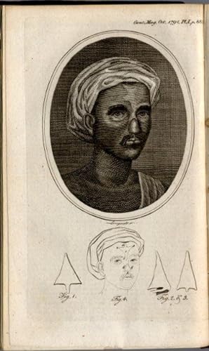
Article on Hindu rhinoplasty. In: The Gentleman's Magazine LXIV, Teil 2, No. 4, (pp.891-892, 1 ganzseitige Kupferstichtafel).
Publication Date: 1794
Seller: Antiq. F.-D. S�hn - Medicusbooks.Com, Marburg, Germany
Seller Rating:
Book First Edition
The Gentleman's Magazine (vollst. Band Juli - Dezember), London, John Nichols, 1794, 8�, pp.585-1212, 21 Taf., marmorierter Halbledereinband der Zeit. - 21176. EIN MEILENSTEIN DER PLASTISCHEN CHIRURGIE FIRST REPORT OF INDIAN RHINOPLASTY ERSTE AUSGABE. Der Bericht von "B.L." in 'The gentleman's magazine' informierte Europas Chirurgen erstmalig �ber die Hindumethode der Nasenplastik. DIESE VER�FFENTLICHUNG MARKIERT BEGINN UND AUSGANGSPUNKT DER MODERNEN PLASTISCHEN CHIRURGIE. Mit Carpue's erfolgreichen rhinoplastischen Operationen ereichte die neue Methode einen ersten H�hepunkt! Der indische Ochsentreiber Cowasjee geriet im Dienste der Britischen Kolonialarmee 1792 in Gefangenschaft des Sultans Tipoo, der ihm die Nase und eine Hand abschneiden lie�. Ein Jahr sp�ter erhielt er durch die Kunst eines Mannes aus der Ziegelmacherkaste bei Poona eine neue Nase aus der Stirnhaut. Die Ver�ffentlichung des Berichtes von B.L. �ber diesen Eingriff enth�lt Hinweise zur Operationstechnik und eine sch�ne, ganzseitige Tafel mit detaillierten Angaben. Nur selten hat ein "Letter to the Editor" eine so st�rmische Entwicklung einer ganz neuen medizinischen Fachrichtung eingeleitet, wie diese Ver�ffentlichung in 'The gentleman's magazine'. FIRST EDITION. "The event which again brougt rhinoplasty to the attention of European surgeons and initiated the revival of the practice that was to lead to its full modern development was the publication in 1794 of the description of a rhinoplastic operation on the bullock-driver Cowasjee, together with an engraving showing various details of the procedure." - Gnudi-Webster, 309. The report of the curious Indian operation in 'The gentleman's magazine' was the turning point in the development of modern plastic surgery. 'The gentleman's magazine' (1731 - 1907) was the first general periodical in Great Britain and so popular that its name became the generic. Zeis, Geschichte der Plastischen Chirurgie, No.441; Zeis-Patterson Index, No.438 calling attention to European rhinoplasty and Tagliacozzi; McDowell, Source Book of Plastic Surgery, 74-88; Gnudi-Webster, The Life and Time of Gaspare Tagliacozzi, 306-316; Bankoff, Story of Plastic Surgery, 38-39; Hirsch, Die geschichtliche Entwicklung der operativen Rhinoplastik, 8-10.
-
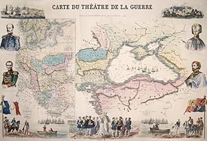
Carte Du Theatre de la Guerre
Published by Artist: Dopter Jules Emile ( - 1879 ) Paris ; issued in: Paris ; ca: 1865; - Jules Emile Dopter (1843-1897): 1867 related to the lithographer and Doucier patents of his brother Jean Vincent Alfred In 1879 the Dopter company was developed by the printer Morel Jean Vincent Marie Dopter (1807-1859) founded this printing company and later also the lithographic institute Krieg Krieg In 1834 he only had 6 gravure printing machines in 1852 he had 17 lithography and 15 gravure printing machines and interesting 150 workers His most important image productions came from these printing machines In the late 1840s the printer specialized in religious images, 1843
Seller: Antique Sommer& Sapunaru KG, M�nchen, Germany
Seller Rating:

Technic: Lithography; colorit: colored; condition: Some folds partly restored, right lower corner replaced, size (in cm): 55 x 84 cm; - Decorative and spledourfull map of the black sea and its bordering countries. Map with the black sean and Russia, Moldavia, Wallachei, Bulgaria and Turkey with Istanbul. With portraits of important men, Abdul- Medjid- Sultan of the ottoman empire, Omer-Pacha- Ottoman General, Nicolas and Prince Menschikoff. On inset maps Greece and Sweden with Norway and Denmark. The map is sourrounded by historical views and events of the Ottoman war at the Krim, (Turkey and Russia, 1853- 1856). Issued from Dopter, Jules Emile, Paris (1843- 1879), a French Lithograph and publisher.
-
Neue und accurate Vorstellung des grossen Ottomannischen Oder T�rckischen Reichs, Dessen Gr�sse, Landschafften, St�dt, Vestungen, Insulen, und Meer-H�fen . Nebst einen Anhang T�rckischer aus den besten Autoribus zusammengetragener Prophezeyhungen.
Published by N�rnberg, Johann Leonhard Buggel, 1717. 8�. Titelkupfer, Titel in Rot und Schwarz gedruckt, 8 Bl., 574 (Pagination springt von 416 auf 447) S., 18 Bl. Register. Mit 16 Kupfertafeln. Lederband d. Zt. mit R�ckenschild und verblasster R�ckenvergoldung., 1717
Seller: Antiquariat Susanne Koppel, Hamburg, Germany
Seller Rating:
First Edition
"Sehr seltene erste Ausgabe. ? Umfangreiches Kompendium �ber die Geographie des Osmanischen Reichs, die Geschichte der T�rken, ihre Religion, Staatsverfassung, Milit�rorganisation, Sitten und Gebr�uche (mit Angaben �ber das "Cahv�" -Trinken), ferner mit Nachrichten �ber die anderen V�lker des Reichs aus fr�heren Reiseberichten. "Anla� zur Abfassung und Ver�ffentlichung des Textes lieferte der Krieg zwischen der habsburgischen Monarchie und dem Osmanischen Reich, der mit dem Sieg der habsburgischen Armee bei Peterwardein (i.e. Novi Sad) im August 1716 und schlie�lich mit dem Frieden von Passarowitz im Juli 1718 endete." (Chatzipanagioti-Sangmeister II, 1157) Die Vorrede mit einem langen Campanella-Zitat ist mit "L. S. O." unterzeichnet. Das Titelkupfer zeigt ein Portr�t von Sultan Ahmed III. (1673-1736). Die originellen, unsignierten Kupfertafeln mit t�rkischen Trachten und Kost�men. ? Einband etwas berieben; Text stellenweise gebr�unt, insgesamt gut erhalten. ? Weller. Lexicon Ps. S. 574; Hayn/Gotendorf VII, 728; Weber 758 (Ausgabe von 1718); nicht bei Apponyi, Lipperheide, H�nersdorff (Kaffee) und in der Blackmer Collection. ".
-
Leineneinband. 127 Seiten mit 68 Farbfototafeln. Format 34,7 x 29,5 cm. Beiliegend C-Print (33,3 x 26,7 cm). Beides im kunstlederbezogenem OSchuber mit Titelpr�gung. Guter Zustand. Cloth. 127 pages with 68 color plates. Separate original C-Print. Slipcase with leatherette. Good condition. Buch und C-Print. Vorzugsausgabe. Fotoaufnahmen aus der Pornofilmszene des San Fernando Valleys bei Los Angeles. Fotos und Text von Larry Sultan. Sprache: englisch. C-Print r�ckseitig signiert und nummeriert. Es ist das Motiv Cabana 2000 und im Buch auf Seite 43 abgebildet. Das Buch ist identisch signiert und nummeriert. Hier die Nr. 2 von insgesamt 20 Exemplaren. Beiliegend farbige Klappkarte zur Ausstellungser�ffnung in der Galerie Zander, K�ln.
-
Ein Winterm�hrchen. Holzstiche von Karl-Georg Hirsch.
Published by Bayreuth, The Bear Press,, 1994
Seller: Galerie Joy Versandantiquariat UG (haftungsbeschr�nkt), Boppard, Germany
Seller Rating:
Book Signed
67 (1) S. Mit 29 Textholzstichen von Karl-Georg Hirsch. 17. Druck der Bear Press Wolfram Benda. - K�stner/L�bbert A 105 a. - Eines vom 12 r�misch num. Exemplaren der Luxusausgabe mit einer blattf�llenden signierten Tuschfederzeichnung (Sultan und K�nigin) auf einem der Vorbl�tter (GA 150). - Druckvermerk vom K�nstler signiert. - Gedruckt auf VL-Handb�tten mit dem Wasserzeichen der Presse. - Schuber mit kleinem Fleck, sonst tadelloser Zustand. - The indicated shipping costs refer to books weighing up to one kilogram. - B�cher, die schwerer als ein Kilogramm oder gr��er als 35 x 25 cm sind, werden als Paket verschickt und kosten innerhalb Deutschlands bis zu zwei Kilogramm 6 Euro, dar�ber hinaus 7 Euro Porto. - Sprache: Deutsch Gewicht in Gramm: 550 8� (28 x 15,5 cm), blaugrauer Pergamentband mit einer in Gold auf Lederintarsie gedruckten Holzstichvignette, R�ckentitel und Kopfschnitt vergoldet, Seidenspiegel mit Goldkante.
-
BOSNIAN & OTTOMAN POSTAL HISTORY
Published by S.l. [probably Vienna, s or 1960s, plates 19th century], 1950
Seller: Antiquariat Dasa Pahor GbR, M�nchen, Germany
Seller Rating:
Book
4�. [29] typescript printed recto on thick paper, with two handmade colour illustrations and 4 lithographed maps coloured in outline in text, 2 full-page colour illustrations in ink pencil, gouache and gilt, 2 original photocopies inserted in plastic sleeves in text, 1 mounted black and white photo with 4 images and title handwritten in ink, 1 mounted hand coloured black and white photo, 4 mounted lithographs in sepia, 2 originally coloured 19th century lithographs, mounted under mats, 2 originally coloured 19th century etchings, mounted under mats. All the pages with printed green line in white margins. Inserted in a contemporary linen binding with marbled end-papers. (Very Good, 4 photocopies of letters missing from plastic sleeves inserted in text, lacking title page?) This is an unusual, privately elaborately made script in German language, describing the postal history in Bosnia in the Ottoman Empire. The text, typed in black, is accompanied with a miniature hand-drawn portrait of Sultan Mahmud II (15 1839) in gilt initial D, a hand-drawn image of a Bosnian merchant hall and quarantine, a full-page hand-drawn portrait of an Ottoman field marshal and governor of Serbian origin Omar Pasha Latas (1806 1871), and a full-page handdrawn portrait of Barbarossa Hayreddin Pasha (c. 1478 1546), an Ottoman admiral of the fleet. Four small hand coloured maps in text have drawn in details and are accompanied by 2 photocopies of examples of letters (4 are missing). A black and white photo showcases four Turkish postal ministers between 1872-1878. A full-page photograph, which has been hand coloured to give it more authentic appearance, shows a drawing of Bosnian costumes, signed by a Croatian nobleman Baron Josef Philipp Vukassovich (Josip Filip Vukasovi?, 1755 1809), who fought for Habsburg Monarchy against both Ottoman Empire and the First French Republic. The last images in the book are original 19th century lithographs representing 9 views of Bosnian cities, and 4 original 19th century coloured etchilhs, showcasing Bosnian costumes. The latter have been mounted under plastic foils and mats. The author, place or year of this detailed, demandingly illustrated work is not known, but was according to the paper probably made in the 1950s or 1960s in Vienna, which was throughout the centuries connected to the Ottoman Empire. Provenience: From a collection of Friedrich �Fritz� Stockinger (1894-1968) an Austrian minister for economy and traffic between 1933-1936. The book appeared in at least two auctions (1977 and ?). Latter collection of Harry Schaefer, a collector of the postal history, Ottoman Empire and the Balka.
-
SCIENCE IN THE OTTOMAN WORLD: Ilm-i hayvanat ve nebatat [The Knowledge of Animals and Plants]
Published by Istanbul: Matbaa-i Amire [1865], 1282
Seller: Antiquariat Dasa Pahor GbR, M�nchen, Germany
Seller Rating:
Book
An early illustrated Ottoman zoology and botany book in a magnificent red morocco binding is a translation of a contemporary German book. The translation, made by a medical doctor to sultan AbdulmejidI, Hekimbasi Salih Efendi, during the time of the Tanzimat, was a major contribution to Ottoman understanding of the Western contemporary biology and terms, which provided the grounds for the further developing of science. Large 8�. [2 pp.] introduction, 89 pp. lithograph and letterpress, [2 pp] blank, 25 black and white double-page lithographed plates, [2 pp.] blank, contemporary red morocco binding with gilt debossed decoration, original pink endpapers, gilt edges (minor age-toning and foxing, binding lightly scratched, lower corners of endpapers accidentally mounted on the inner side of the boards and torn with a narrow loss of paper possibly due to the leaking glue during the bookbinding process). An early illustrated scientific book in Ottoman language, published in 1865 and showcasing anatomy of animals and images of various plants, is a translation of Naturhistorischer Schulatlas f�r den methodischen Unterricht [Atlas of Natural History for a Methodical Lesions] by Carl Arendts, which was published in Leipzig in 1858 and a year later in under a French title Elements d'histoire naturelle et de technologie, a l'usage de la jeunesse. The book was published in the enlightened political reforms of the Tanzimat Era (1839-75). The text should not be seen as a translation in the Western sense, but an introduction of the contemporary scientific discoveries and learning methods, which became a ground for a development of the Ottoman modern science and its separation from the traditional Islamic perception. The translator was Mehmet Salih Efendi, also known as Hekimbasi Salih (Hekimbasi meaning the chief physician to the sultan). Salih was born in Istanbul and in studied medicine at the Imperial Military School of Medicine, the first Ottoman institution of such kind, founded in 1827 by sultan Mahmud II. and based on the Western examples. The lectures were held in French. After the graduation Salih briefly worked in Cairo, but returned to Istanbul after a year to serve as a second chief physician to sultan AbdulmejidI and to lecture at the Imperial Military School of Medicine. He was soon promoted to the chief physician (Hekimbasi), the position he held under a reign of the following two sultans and he supervised all the medical institution in the city. In 1866, Hekimbasi Salih played an important role in organizing a large conference to stop a great plague epidemic in Europe and the Ottoman lands and in determining the International Quarantine rules. As an interesting information, Salih's house, an attractive red wooden mansion on the Bosporus called Hekimbasi Yalisi, where he planted a herbal garden and was studying the medical effect of the plants. survives until today. The book is very rare. The same title with almost identical binding is housed in the Turkish Historical Society Library in Ankara (A007373, A/5393). We could find one example of the book on Worldcat (Bavarian State Library). References: O?zege, Eski harflerle 8896. OCLC 785851545.
-
Medicine / Modern Medicine in the Ottoman Empire: Precis de percussion et d'auscultation � l'usage de ses lecons, imprimerie de l'indicateur Byzantine
Published by Istnabul : Inprimerie [sic!] de L'Indicateur Byzantin ., 1843
Seller: Antiquariat Dasa Pahor GbR, M�nchen, Germany
Seller Rating:
Book
A rare pioneering work on the modern medicine in the Ottoman Empire was written in French by an Austrian medical doctor Karl Ambros Bernard in Istanbul. 8�, [4 pp.], 90 pp. with an introduction in French and Ottoman, original green boards with lettering and illustrations , brown calf spine (binding slightly scuffed on the edges, minor staining, light water staining mostly to the edges of the rear endpapers, , old Ottoman stamp, otherwise in a good condition). A medical book in French language, published in Istanbul, is a pioneering work on the modern medical education in Istanbul. It includes the lectures, mostly on diseases, for students of the Imperial medical school in Istanbul. The image on the back cover illustrates a class in the school. The author was an Austrian medical doctor Karl Ambros Bernard (Charles Ambroise Bernard, 1810-1844), who is known as a founder of the modern medical education and pharmacology in the Ottoman Empire and a pioneer of pharmaceutical terms in Ottoman / Turkish language. Bernard was born in Jilemnice (German Starkenbach) in today's Czech republic. After finishing the study of medicine, he was send to Bukowina to fight the cholera. In 1838, he moved to Istanbul on the invitation of the sultan Mahmud II. to reorganize the Imperial medical school for the army doctors in Galata based on the principle of the Viennese Josephinum. During his six years in Istanbul Karl Ambros Bernard became a pioneer of the modern pharmacology and medical education in Istanbul. He published four medical books, one of which he translated to Ottoman, using new medical terminology. In 1844, Bernard published his most famous and influential book, Pharmacopoea Castrensis Ottomana, which he, according to the introduction from September 16th, intended to translate into Turkish soon. Bernard died suddenly a month later at the age of 34 and was buried in Istanbul on November 2nd, 1844. Today a memorial plate on the gate to the Catholic Church Saint Mary Draperis on Istiklal Avenue in Istanbul commemorates this ingenious medical doctor. We would not find any institutional examples on Worldcat.
-
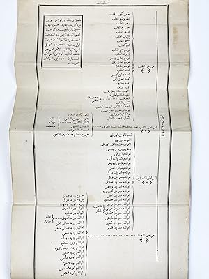
Makalat-i Tibbiye
Published by Istanbul: Takvim-i VakaI, [1843]., 1259
Seller: Antiquariat Dasa Pahor GbR, M�nchen, Germany
Seller Rating:
Book
8�: [4 pp., index], 149 pp., 6 folding charts, contemporary marbled boards, restored calf spine, old paste down tile to cover bearing title, original pink endpapers (old ottoman annotations on first and last blank pages, slightly stained, mostly in margins, boards slightly scuffed and rubbed with small loss of paper, sporadic small tears in margins, lines on the decoration on the first page overlined with light black pen, the but overall, in a good condition). FIRST AUTOPSY IN THE OTTOMAN EMPIRE: [Medical Reports] A thesis on the first autopsy ever conducted in the Ottoman Empire, performed by Karl Ambros Bernard in 1841, at the Austrian Hospital in Istanbul, written by Hayrullah Efendi, a future Ottoman diplomat and prolific author. In 1844, Hayrullah Efendi, one of the first wave of students trained in the new Westernized curriculum at the Imperial School of Medicine, published his thesis on the first autopsy conducted in the Ottoman Empire. It was performed by Karl Ambros Bernard, lead instructor at the Imperial Medical School. The autopsy was held at the Austrian Hospital in Istanbul employing the corpse of an apparently healthy Croatian, who suddenly died in a work accident. The procedure occurred with with the special permission by the sultan, who acted at the urging of his personal physician and the official head of the medical school, Abd�lhak Molla. The work includes a description of the first highly successful autopsy, followed by reports on some of Bernard's subsequent post-mortems, and includes various fascinating medical observations, augmented by six charts detailing the procedures. The first autopsy performed in the Ottoman world, overseen by Bernard, is described: "While a Croatian worker was gathering pieces of wood a big stick fell on his head. He died immediately. His body was brought to the Austrian Hospital, and the director of Mekteb-i Tibbiye-i Sahane, monsieur Bernard, performed the autopsy. During the procedure, I wrote about the findings and other medical school students, followed up the the procedure, I wrote about the findings and other medical school students, followed up the observations of Monsieur Bernard. Monsieur Bernard found that the size of the Croatian worker's heart was 2 times bigger than normal. In addition to that, the aortic valves were approximately covering the entrance of the aorta. However, this man's body was in better condition than that of most healthy men, and his illness was not known. This man was a hauler of heavy luggage in his daily life and while he was working, he did not complain about anything." (Akinci S. Dissection and Autopsy in Ottoman Empire Medicine, vol. 2, 1962; quoted after OGUZ UYSAL, 2009, p. 107). Bernard's autopsies revealed to his Ottoman students not only the whole new world of the inner parts of the human body, but also the fact that a seemingly healthy person can unknowingly carry diseases. Further autopsies, performed by Bernard and described in the book, prove that various health issues can often be due to causes which were not directly connected to the location of the visible injury or problem. Bernard's autopsies became a foundation of modern Ottoman medicine and played an important role in the criminal justice system in the country (ex. the coroner's office / forensic sciences). After Bernard's sudden death in 1844, his lectures on forensic medicine were continued by Servicen Efendi. The author of the present work was Bernard's student, Hayrullah Efendi (1818 1866), who was during his time at the Medical School awarded several medals for his work and submitted his report on the autopsies performed at the Imperial Medical School as his doctoral thesis. Hayrullah was a son of Abd�lhak Molla (1786 1854), a medical doctor who founded the Imperial Medical School in 1827, and who arranged for Bernard to be given permission to perform the first autopsies in the Ottoman Empire. In the years after his thesis, Hayrullah Efendi held several important public offices, including as head of the Medical School and Minister of Education, as well as authoring several books on medicine, history and geography. He died suddenly in Tehran while on a diplomatic mission. Worldcat lists 4 institutional examples of the present work (Biblioth�que nationale de France, Hungarian Academy of Sciences Library, Library of Congress and Bogazici University Library). The standard bibliography of Ottoman books, �zege, incorrectly claims that the work is a translation after an author called Du Bois (�zege 11991). References: OCLC 949488288, 952855689, 470415463. Cf.: Salih Murat AKKIN, 'A Glimpse into the Process of Gaining Permission for the Educational Dissection of Human Cadavers in the Ottoman Empire', Clinical Anatomy 27(7), 2014, pp. 964 971. Nermin CELIK, 'The Start of Conducting Dissection in Ottoman Empire', International Journal of Basic and Clinical Medicine (online source: nkmj-3-53-En.pdf); Mahmut AsIRDIZER, Adli Bilimler Ve Adli Tibbin Tarihcesi (2021); Yusuf ATAN, Ilhan BAHSI, Zekeriya TATAROGLU, Mustafa ORHAN and Murat CETKIN, 'Dr. Charles Ambroise Bernard: T�rkiyede Adli Otopsinin Baslangici / Dr. Charles Ambroise Bernard: Beginning of Forensic Autopsy in Turkey', Adnan Menderes �niversitesi Saglik Bilimleri Fak�ltesi Dergisi 2 (3), 2018, pp. 28-31; Polat OGUZ Cem UYSAL, 'History of Forensic Medicine in Turkey', Legal Medicine 11(3), 2009, pp. 107-110 et al.
-
IRAQ / IRAN PETROLEUM (OIL) HISTORY / DIPLOMATIC HISTORY: [A Complete Collection of the 3 Official Maps (on 4 Sheets) certifying the Ottoman-Persian Boundary Survey by the Shatt Al-Arab Waterway, along today s Iraq-Iran Frontier, according to the Anglo-Turkish Declaration of July 29, 1913].
Published by London: Geographical Section, War Office, []., 1913
Seller: Antiquariat Dasa Pahor GbR, M�nchen, Germany
Seller Rating:
Extremely rare the complete series of the 3 maps (on 4 sheets) of the Ottoman-Persian Boundary Survey in the vicinity of the Shatt Al-Arab waterway, along today s Iraq-Iran frontier, above the head of the Persian Gulf, as mandated by the Anglo-Turkish Declaration of July 29, 1913; this boundary settlement was surveyed by Indian Army engineers under the supervision of Sir Percy Cox, the British 'fixer in the Persian Gulf, and was forced upon both the Ottomans (who controlled Iraq) and Persia so that the British-controlled oil concessions in southwestern Persia (the first commercially viable petroleum operations in the Middle East) had ample space; while the boundary as demarcated here was never formally ratified, it served as the de facto Iraq-Iran frontier for decades, although it inevitably pleased nobody, fueling local tensions, being one of the causes of the Iran Iraq War (1980-88).Iraq, which had been controlled by the Ottoman Empire since 1534, maintained an almost 1,600 km-long-border with Persia. Over the centuries, the two empires had fought over this frontier, causing it to shift in places. By the 19th century, the border had settled into a roughly defined fashion, although its precise delineation was unclear. Ottoman-Persian Boundary commissions were convened in 1843-47 and 1848-65, but they failed to define an exact boundary. A final Ottoman-Persian Boundary Commission was convened in 1907-13, and almost immediately its operations became ensnared in high profile global geopolitics. To make a long story short, while for much of the 19th century, the Ottoman Empire was allied with Britain and France, from the 1890s, the Sultan gravitated towards an alliance with Germany, much to the alarm of Westminster. Beginning in 1903, the Germans stated to build the Baghdad Railway, that would, if completed, link the heart of Iraq to Istanbul, and then on to Berlin, giving the Kaiser the upper hand in the Mesopotamia. The British, who were consolidating their power in the Persian Gulf (making alliances with the sheikhs of Kuwait, Bahrain, and Qatar, etc.), feared that the German designs would not only compromise their efforts in the region, but could even pose a danger to their hold over India. Meanwhile, Britain and Russia decided to bury their 80-year-long rivalry in Asia, known as the 'The Great Game , signing the Anglo-Russian Convention of 1907. This accord not only established agreed zones of influence for the two powers in Central Asia, but also divided Iran (which was ruled by the weak, ailing Qajar Dynasty) an into colonial zones of influence. The British were given control over southeastern Persia, with the Russians given sway over the northern regions, while a strip of the country running from the southwest to the centre was a 'Neutral Zone . However, in reality, the British dominance of the Persian Gulf pretty much gave them control over all of Southern Iran. In a globally transformative historical event, the first commercially exploitable oil deposits in the Middle East were discovered in 1908 at Maidan i Naftan, near 'Masjid Solaim?n , in the extreme southwestern corner of Persia, a region known as 'Arabistan (the western part of today s Khuzestan Province, Iran), due to its majority ethnic Arab population. The find was located by teams working for the flamboyant Anglo-Australian tycoon William Knox D Arcy (1849 1917), who led the Anglo-Persian Oil Company (APOC), and which was backed by powerful British political and commercial entities, including the Indian Government and the Royal Navy. APOC was able to claim ownership and control over the oilfields due to a 1901 agreement with the Persian Shah. Critically, the Persian oil discoveries not only promised to boost the British industrial economy but would also allow the Royal Navy to switch its fleets from coal to oil power, giving it an edge over its rivals. PLEASE SEE OUR WEB PAGE FOR A LONGER DESCRIPTION.
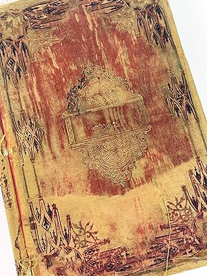

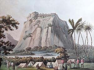

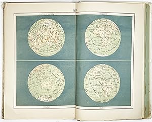
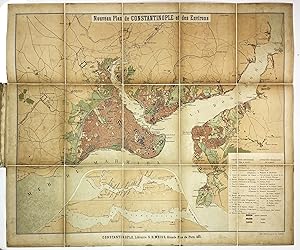
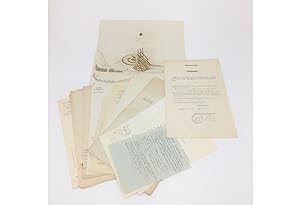
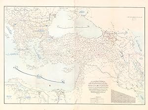
![Seller image for Muharebat-i meshure-i osmaniye alb�m� [Album of Famous Ottoman Battles] for sale by Antiquariat Dasa Pahor GbR](https://pictures.abebooks.com/inventory/md/md31521306401.jpg)
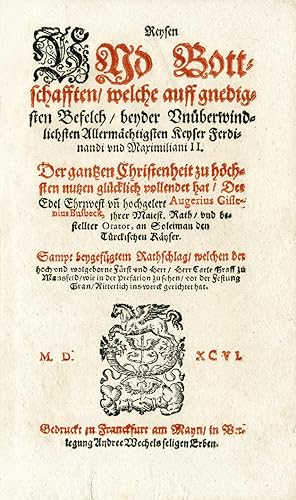
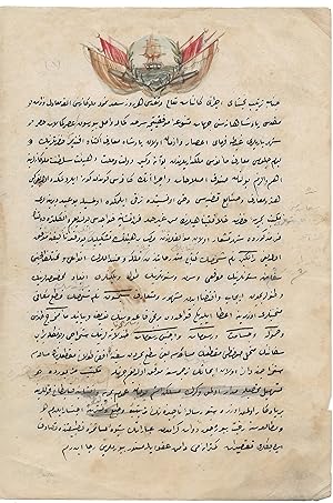
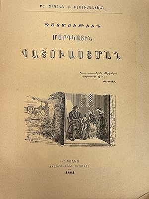
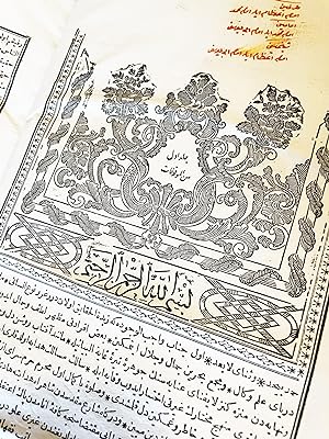
![Seller image for Navigations Karte Der Donau von Semlin an bis zu ihrem Ausfluss ins Schwarze Meer : zur genauesten Kentnis aller in derselben befindlichen Inseln, Sandb�nke, Wirbel, Klippen u.s.w. so wie aller an den beiderseitigen Ufern gelegenen St�dte, D�rfer und andere Ortschaften, wobei zugleich die verschiedene Breite und Tiefe des Stroms bestimt angegeben ist, zuerst aufgenomm[m]en von dem k.k. Pontonier Hauptmann von Lauterer, da derselbe den k.k. Herrn Internunzius Freyherrn von Herbert bis Ruszug f�hrte, hierauf aber weiter ausgearbeitet und verbessert von dem k.k. Hauptmann Freyherrn von Tauferer bei Gelegenheit, als derselbe das erste Seeschiff aus der Kulpa auf der Donau nach Konstantinopel f�hrete. for sale by Antiquariat Dasa Pahor GbR](https://pictures.abebooks.com/inventory/md/md31050681268.jpg)
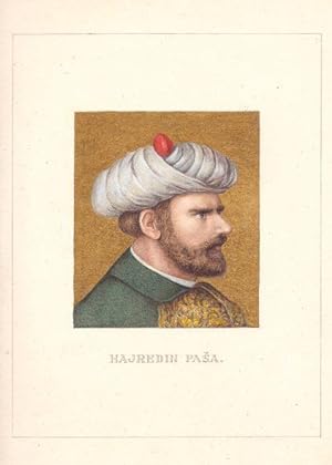
![Seller image for SCIENCE IN THE OTTOMAN WORLD: Ilm-i hayvanat ve nebatat [The Knowledge of Animals and Plants] for sale by Antiquariat Dasa Pahor GbR](https://pictures.abebooks.com/inventory/md/md30772716207.jpg)
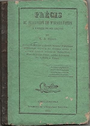
![Seller image for IRAQ / IRAN PETROLEUM (OIL) HISTORY / DIPLOMATIC HISTORY: [A Complete Collection of the 3 Official Maps (on 4 Sheets) certifying the Ottoman-Persian Boundary Survey by the Shatt Al-Arab Waterway, along today s Iraq-Iran Frontier, according to the Anglo-Turkish Declaration of July 29, 1913]. for sale by Antiquariat Dasa Pahor GbR](https://pictures.abebooks.com/inventory/md/md31404942520.jpg)