Distance Measuring Equipment (DME)
Pramod Prabhakaran
"Aerospace Professional | Technical Documentation & Project Management Expert"
Distance Measuring Equipment (DME) is a radio navigation technology used in aviation to determine the distance between an aircraft and a ground station. It works by sending and receiving radio signals between the aircraft and the ground-based DME transponder.
Here's how it works:
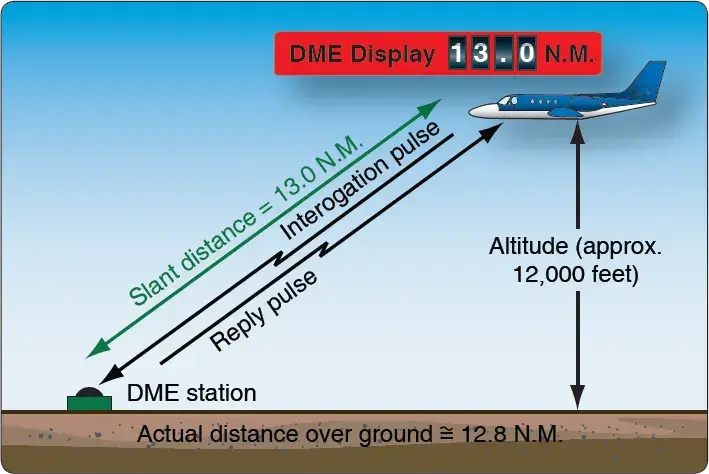
Interrogation and Reply: The aircraft's DME interrogator sends out a series of pulses at a specific frequency (usually in the UHF band). This interrogation signal is received by a DME ground station.
Ground Station's Reply: The DME ground station receives the interrogation signal and responds by sending a series of pulses back to the aircraft. This reply signal contains a unique identification code for that particular DME station.
Time Measurement: The aircraft measures the time it takes for the interrogation signal to travel to the ground station and for the reply signal to travel back. This is known as the "time of flight."
Distance Calculation: Since radio waves travel at a constant speed (the speed of light), the DME unit on the aircraft can calculate the distance to the ground station based on the time it took for the signals to travel.
Display: The calculated distance is then displayed in nautical miles (NM) on the aircraft's navigation display.

The operating frequency for DME systems is in the Ultra High Frequency (UHF) band, typically between 962 MHz and 1213 MHz. The specific frequencies used for DME are:
Interrogation Frequency: 1025 MHz to 1150 MHz
Reply Frequency: 962 MHz to 1213 MHz
The system operates on a paired frequency system, meaning there are specific pairs of frequencies used for interrogating and replying. For example, if the aircraft interrogates on 1025 MHz, the ground station will reply on its corresponding paired frequency (e.g., 962 MHz).
DME is widely used in aviation because of its accuracy and reliability in providing distance information, making it an essential tool for navigation and approach procedures. It's often used in conjunction with VOR (VHF Omni-Directional Range) for accurate navigation in both en-route and terminal phases of flight.
Disclaimer : The opinions expressed in this article represent a culmination of insights gathered from multiple sources, including personal experiences and extensive research. The primary objective of this article is to share information, encourage critical thinking, and foster constructive discussions among our readers. While every effort has been made to ensure the accuracy of the information presented, inadvertent errors may have occurred. Readers are encouraged to engage in thoughtful discussions based on the content presented here. Your perspectives, questions, and contributions are valued and can enrich the overall discourse.